Caltech’s Einstein Papers Project is a Window into the Mind of a Genius

Albert Einstein on the beach in Santa Barbara in 1931 (The Caltech Archives)

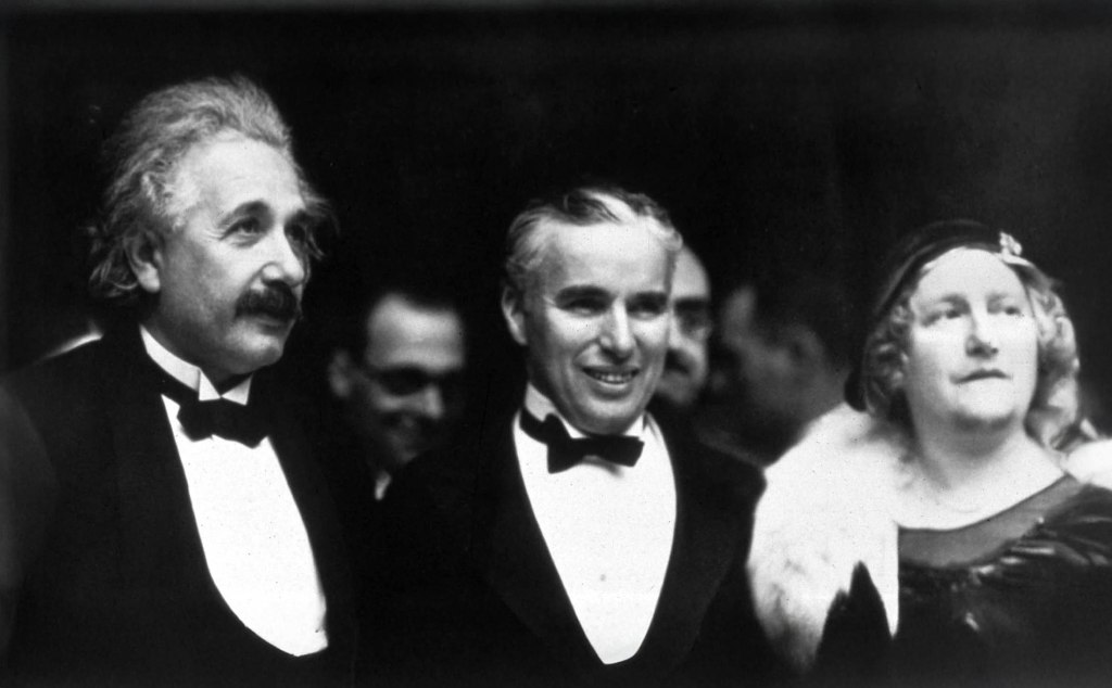
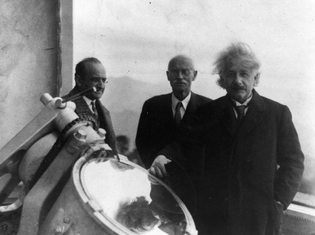
We wrote a piece a while back about the three winters Albert Einstein spent in Pasadena, a little-known chapter in the life of a man who changed how we understand the universe. It was our way of showing how Einstein, often seen as a figure of European academia and global science, formed a real affection for California and for Pasadena in particular. It’s easy to picture him walking the streets here, lost in thought or sharing a laugh with Charlie Chaplin. The idea of those two geniuses, one transforming physics and the other revolutionizing comedy, striking up a friendship is something worth imagining.

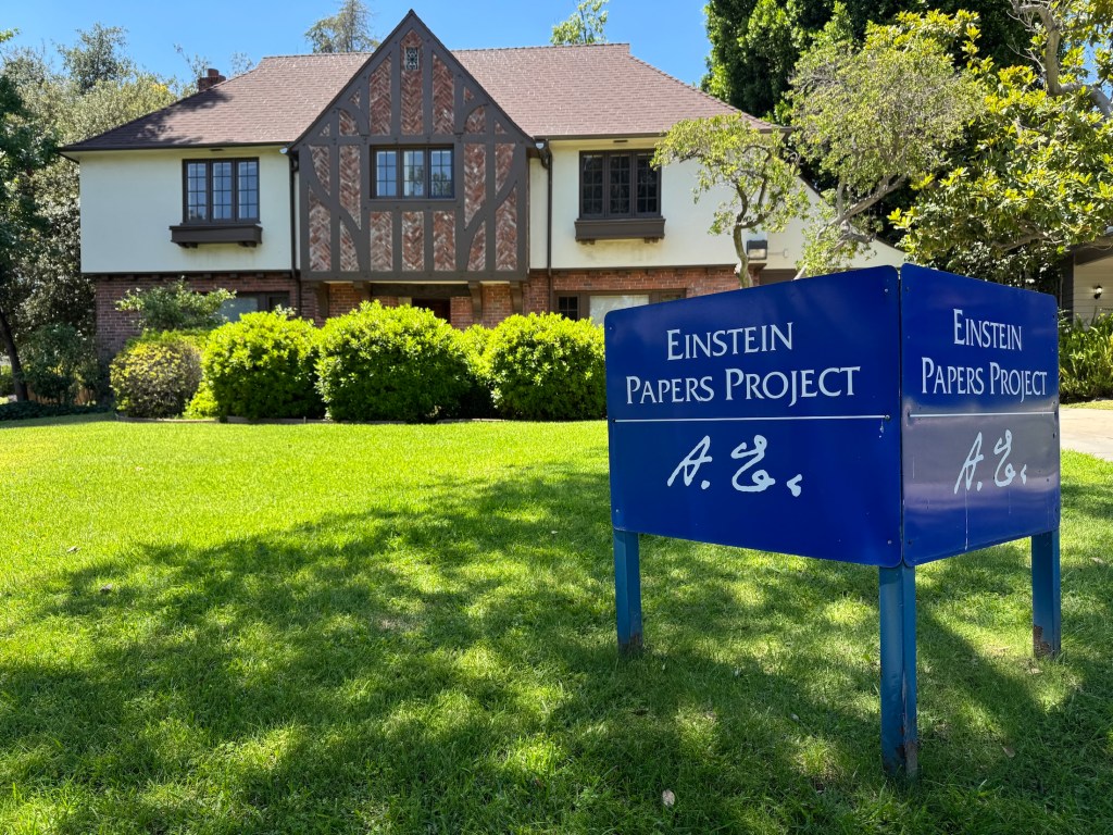
But Einstein’s connection to Pasadena didn’t end there. It lives on in a small, nondescript building near the Caltech campus, where a group of researchers continues to study and preserve the legacy he left behind.

The Einstein Papers Project (EPP) at Caltech is one of the most ambitious and influential scientific archival efforts of the modern era. It’s not just about preserving Albert Einstein’s work—it’s about opening a window into the mind of one of the most brilliant thinkers in history. Since the late 1970s, a dedicated team of scholars has been working to collect, translate, and annotate every significant document Einstein left behind. While the project is headquartered at the California Institute of Technology, it collaborates closely with Princeton University Press and the Hebrew University of Jerusalem, which houses the original manuscripts.

Einstein at the Santa Barbara home of Caltech trustee Ben Meyer on Feb. 6, 1933.
(The Caltech Archives)

The idea began with Harvard physicist and historian Gerald Holton, who saw early on that Einstein’s vast output—scientific papers, personal letters, philosophical musings—deserved a meticulously curated collection. That vision became the Einstein Papers Project, which has since grown into a decades-long effort to publish The Collected Papers of Albert Einstein, now spanning over 15 volumes (and counting). The project’s goal is as bold as Einstein himself: to assemble a comprehensive record of his life and work, from his earliest student notebooks to the letters he wrote in the final years of his life.

Albert Einstein and Charlie Chaplin during the premiere of the film ‘City Lights’. (Wikipedia)

Rather than being stored in a traditional library, these documents are carefully edited and presented in both print and online editions. And what a treasure trove it is. You’ll find the famous 1905 “miracle year” papers that revolutionized physics, laying the foundation for both quantum mechanics (which Einstein famously derided) and special relativity. You’ll also find handwritten drafts, scribbled calculations, and long chains of correspondence—sometimes with world leaders, sometimes with lifelong friends. These documents don’t just chart the course of scientific discovery; they reveal the very human process behind it: doubt, revision, flashes of inspiration, and stubborn persistence.

At the Mount Wilson Observatory with the Austrian mathematician Walther Mayer, left, and Charles St. John of the observatory staff. (The Caltech Archives)

Some of the most fascinating material involves Einstein’s attempts at a unified field theory, an ambitious effort to merge gravity and electromagnetism into one grand framework. He never quite got there, but his notebooks show a mind constantly working, refining, rethinking—sometimes over decades.

But the project also captures Einstein the person: the political thinker, the pacifist, the refugee, the cultural icon. His letters reflect a deep concern with justice and human rights, from anti-Semitism in Europe to segregation in the United States. He corresponded with Sigmund Freud about the roots of violence, with Mahatma Gandhi about nonviolent resistance, and with presidents and schoolchildren alike. The archive gives us access to the full spectrum of who he was, not just a scientist, but a citizen of the world.

The Einstein Papers Project home near Caltech in Pasadena (Photo: Erik Olsen)

One of the most exciting developments has been the digitization of the archive. Thanks to a collaboration with Princeton University Press, a large portion of the Collected Papers is now freely available online through the Digital Einstein Papers website. Students, teachers, historians, and science nerds around the globe can now browse through Einstein’s original documents, many of them translated and annotated by experts. The most recent release, Volume 17, spans June 1929 to November 1930, capturing Einstein’s life primarily in Berlin as he travels across Europe for scientific conferences and to accept honorary degrees. The volume ends just before his departure for the United States. Princeton has a nice story on the significance of that particular volume by EPP Editor Josh Eisenthal.

The California Institute of Technology, CalTech (Photo: Erik Olsen)

For scholars, the project is a goldmine. It’s not just about Einstein—it’s about the entire intellectual climate of the 20th century. His collaborations and rivalries, his responses to global upheaval, and his reflections on science, faith, and ethics all provide insight into a remarkable era of discovery and change. His writings also show a playful, curious side—his love of music, his wit, and his habit of thinking in visual metaphors.

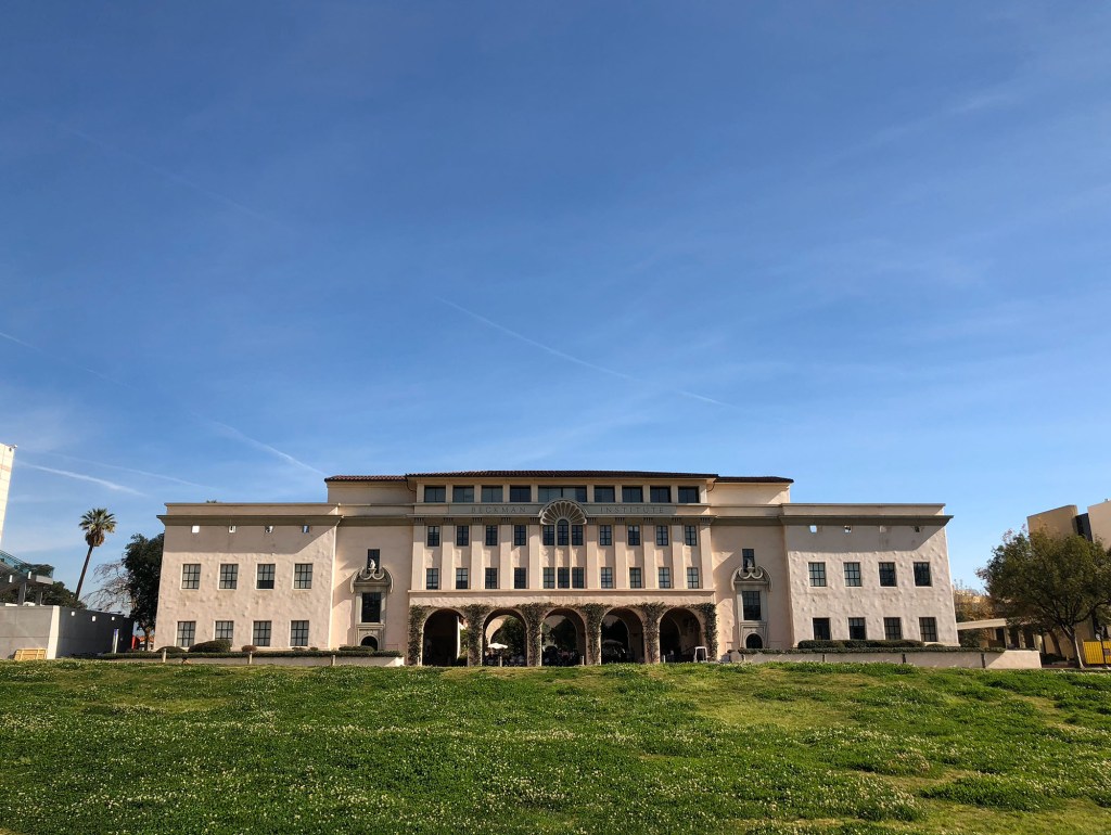
Caltech’s role in all this goes beyond simple stewardship. The Einstein Papers Project is a reflection of the institute’s broader mission: to explore the frontiers of science and human understanding. For decades, Caltech has been a breeding ground for great minds. As of January 23, 2025, there are 80 Nobel laureates who have been affiliated with Caltech, making it the institution with the highest number of Nobelists per capita in America. By preserving and sharing Einstein’s legacy, Caltech helps keep alive a conversation about curiosity, responsibility, and the enduring power of ideas.

The Fight for California’s Coastline and the Future of the Coastal Commission

For over 50 years, the California Coastal Commission has protected public access and natural beauty, but growing challenges—wildfires, housing shortages, and political pressure—are testing its authority like never before.

California Coast at Big Sur (Erik Olsen)

Having lived for nearly 20 years on the East Coast, I’ve witnessed firsthand how vast stretches of coastline have been heavily developed, often turning pristine shores into exclusive enclaves inaccessible to the general public. In the latter half of the 20th century, America saw a surge in coastal development, driving beachfront property values to unprecedented heights. This boom was accompanied by exclusionary practices from coastal property owners and municipalities, limiting access and reinforcing barriers to the shore. From gated beachfront mansions in the Hamptons to private communities along the Jersey Shore, not to mention the vast development of the coast of Florida (Carl Hiaasen shout out!), many coastal areas are reserved for a privileged few, limiting public access and enjoyment of natural spaces. In stark contrast, California learned from these mistakes early on, adopting a fundamentally different approach focused on keeping its coastline accessible and preserved for everyone.

Many beaches in the Hamptons are private. Unlike California, which has strong public access protections under the California Coastal Act, New York follows a mix of public and private beach ownership laws. In the Hamptons, beachfront property owners often hold rights extending to the high tide line, meaning much of the sandy shore is off-limits to the general public.

This ethic of preservation and accessibility has profoundly shaped California’s coastal policies and given rise to institutions specifically tasked with safeguarding the shore. The ethic of preserving California’s coast stretches back more than a century, championed by early conservationists like Julia Platt, a pioneering marine biologist and activist. Platt was a fascinating figure, and we previously covered her story, which you can read here. In the late 19th and early 20th centuries, Monterey’s coastline was being ravaged by sardine canneries and industrial operations that polluted the bay and threatened marine life. Defying societal barriers, Platt became mayor of Pacific Grove in 1931 and secured public control over the town’s intertidal zones, ensuring their protection from commercial exploitation.

Hovden Cannery, 886 Cannery Row, Monterey, Monterey County, CA (Library of Congress)

That ethic of appreciation and commitment to coastal preservation remained deeply embedded in California’s identity as the state moved into the 20th century. By the 1970s, this consciousness transformed into action, leading to formal protections that would shape the coastline for generations. Spanning approximately 840 miles from San Diego’s sun-drenched shores to the wild, windswept cliffs of Crescent City, California’s coastline did not remain protected and accessible by accident. It was the result of a concerted effort to safeguard its natural beauty and ensure public access—an effort that culminated in the establishment of the California Coastal Commission, a state agency created to oversee and enforce these critical protections.

The Coastal Commission’s story began in 1972 amid growing environmental awareness and concerns about unchecked development. California residents, alarmed by the threat of losing their treasured coastline to developers, launched grassroots campaigns resulting in Proposition 20—the Coastal Initiative. This public referendum created the Coastal Commission initially as a temporary regulatory body.

Senate President pro-tem Jim Mills led a bicycle tour of the coast from San Francisco to San Diego, stopping for press conferences and public events in coastal communities along the route. (Credit: California Coastal Commission)

In 1976, recognizing the importance of long-term coastal preservation, the California Legislature passed the Coastal Act, permanently institutionalizing the Coastal Commission and its values (values shared by a majority of Californians, I should add). Key legislative figures included Assemblymember Alan Sieroty and Senator Jerry Smith. Peter Douglas, a passionate advocate for environmental justice who later became the Commission’s long-serving Executive Director, was instrumental in drafting the Coastal Act. Born in Berlin and fleeing Nazi Germany during World War II, Douglas’s personal experiences deeply influenced his dedication to environmental protection. One of his most lasting statements about the coast is, “The coast is never saved, it is always being saved.” (Makes for a good T-shirt.)

Peter M. Douglas (1942–2012) was an environmental activist, UCLA law graduate, and key author of Proposition 20, which established the California Coastal Commission. He co-authored the 1976 Coastal Act and served as its Executive Director for 26 years.
(University of California, Berkeley)

Under Douglas’s leadership, which spanned from 1985 until his retirement in 2011, the Coastal Commission achieved significant conservation victories. One landmark success was securing public access to Malibu’s Broad Beach in 1981, previously restricted to wealthy homeowners (many of them famous celebrities). Similarly, the Commission prevented extensive development of Orange County’s Bolsa Chica Wetlands, preserving this crucial ecological habitat and protecting numerous bird and marine species. Also in Orange County, the historic cottages at Crystal Cove State Park were preserved as affordable accommodations rather than being transformed into a luxury resort. Douglas was tenacious and stubborn in his efforts to protect the coast. He was “the world’s best bureaucratic street fighter,” according to Steve Blank, a member of the commission, who spoke to The New York Times in 2010.

Crystal Cove’s unspoiled coastline remains protected thanks to the California Coastal Commission’s efforts to preserve both its natural beauty and fragile ecosystems. Once threatened by development, this stretch of shoreline continues to thrive as a sanctuary for marine life and a place for the public to experience California’s coast as it once was. (Photo: Erik Olsen)

Perhaps the Commission’s most publicized battle was with billionaire Vinod Khosla over Martins Beach near Half Moon Bay. After purchasing land surrounding the beach in 2008, Khosla closed the access road, igniting a lengthy legal fight. The Commission, alongside advocacy groups, successfully argued that public beach access must be maintained, culminating in court decisions mandating the reopening of Martins Beach to the public. It was a significant affirmation of the public’s coastal rights.

Khosla became something of a vilified figure, perhaps for a good reason. As of March 2025, the legal dispute over public access to Martins Beach continues. In May 2024, San Mateo County Superior Court Judge Raymond Swope ruled that the lawsuit filed by the California State Lands Commission and the California Coastal Commission against Khosla could proceed. The state agencies argue that, based on the public’s longstanding use of the beach, access should remain open under the legal doctrine of implied dedication.

Vinod Khosla speaks at South by Southwest 2024 (Wikipedia)

Beyond these high-profile victories, the Commission diligently protects scenic coastal views by regulating construction along vulnerable bluffs, safeguarding habitats for endangered species like the California least tern and the Western snowy plover. The significance of this protection extends far beyond simply claiming a spot on the sand or catching a wave. The California coast is a global treasure trove of biodiversity, shaped by the collision of cold and warm ocean currents, rugged geology, and an array of microclimates. Its kelp forests, some of the most productive ecosystems on Earth, form towering underwater cathedrals that shelter fish, sea otters, and invertebrates while sequestering carbon and buffering coastal erosion. Tide pools teem with anemones, sea stars, and scuttling crabs, while offshore waters host migrating gray whales, pods of orcas, and dolphin super pods. Few places on Earth does such a dramatic convergence of oceanic and terrestrial life create a living laboratory as dynamic, fragile, and irreplaceable as California’s coastline.

Safeguarding these resources has always been a core part of the Coastal Commission’s mission. Yet, the Commission’s broad regulatory authority hasn’t been without controversy (understatement alert!). In fact, there’s been a lot over the years, and in particular right now. Critics argue it often overreaches, impacting private property rights and overriding local governance. Property owners have faced severe challenges due to stringent permit requirements and mandatory easements for public access. Furthermore, vast amounts of red tape have often contributed to delays and higher costs, fueling tension between environmental protection and economic development, particularly in the context of California’s ongoing housing crisis. The commission’s plans for managed retreat in response to coastal erosion have sparked ongoing concern among coastal property owners.

Elephant seal colony at San Simeon (Erik Olsen)

Jeff Jennings, the mayor of Malibu commented: “The commission basically tells us what to do, and we’re expected to do it. And in many cases that extends down to the smallest details imaginable, like what color you paint your houses, what kind of light bulbs you can use in certain places.

The challenges of balancing conservation with development have become even more urgent in the face of devastating wildfires, such as the Palisades Fire. This historically destructive blaze burned numerous homes along the coast, leaving behind not only physical devastation but also a complex and expensive rebuilding process. Restoring these communities requires immense resources, regulatory approvals, and long-term planning, raising questions about whether the Coastal Commission is up to the task.

Stretch of Malibu destroyed in the Palisades fire (Erik Olsen)

Even Governor Gavin Newsom has been critical of the Commission, citing delays and bureaucracy that may hinder swift rebuilding efforts. The ongoing tension between preserving the natural environment and addressing the needs of displaced residents continues to test the Commission’s authority and effectiveness. Before dismantling the Commission and stripping it of its authority as the guardian of the coast, we must ask ourselves what it would mean to lose an agency that has stood for public access, environmental protection, and coastal preservation for over 50 years. The consequences of weakening its influence could reshape California’s coastline in ways that future generations may come to regret.

The California Coastal Commission has 12 voting members and 3 non-voting members, appointed by the Governor, the Speaker of the Assembly, and the Senate Rules Committee. Six of these are locally elected officials, and six are public members. They are supported by key figures like Executive Director Kate Huckelbridge (the first woman to lead the California Coastal Commission in its 50-year history) and Chair Justin Cummings. However, the Commission now faces mounting pressure as it navigates growing criticism over its efficiency and decision-making. Some argue that the Commission has become too rigid, impeding much-needed development, while others warn that weakening its authority would open the door to rampant privatization and environmental degradation. Surely, there is a middle ground?

Bixby Bridge at Big Sur (Erik Olsen)

But before dismantling an institution that has served as California’s coastal safeguard for over five decades, we must fully understand what is at stake. The California Coastal Commission has played a crucial role in preserving public access, protecting natural habitats, and maintaining the scenic beauty of the shoreline. Its legacy is visible in the open beaches, thriving wetlands, and untouched bluffs that define the state’s coastline. Stripping away its influence could have lasting consequences, reshaping California’s shorelines in ways that future generations may find irreversible and regrettable. Changes to the Commission’s authority may be necessary, at least temporarily, to expedite rebuilding efforts for those who have lost their homes. However, we must be cautious about how much power is stripped away, ensuring that any reforms do not undermine the very protections that have kept California’s coast open and preserved for decades. 

Salt to Salvation: The Desalination Revolution in California’s Drought Battle

Visibly low water conditions at Shasta Lake in Shasta County, on October 13, 2022.
Andrew Innerarity / California Department of Water Resources.

Water, water, every where, nor any drop to drink. 

— Samuel Taylor Coleridge’s poem The Rime of the Ancient Mariner. 

Desalination, the process of turning seawater into potable water, is gaining traction as a viable solution to California’s perennial drought issues. The Golden State, with its sprawling 850-mile coastline and notorious aridity, is primed for desalination to play a pivotal role in its water management strategies.

The mission of the Seawater Desalination Test Facility in Port Hueneme, Ventura. John Chacon / California Department of Water Resources

California’s history with droughts is long and storied, with the state experiencing some of its driest years on record recently. Traditional sources of water, such as snowpacks and reservoirs, have become increasingly unreliable due to the erratic patterns of climate change. While an atmospheric river storm in 2023 and several powerful storms in 2024 and 2025 significantly eased California’s drought conditions for the time being, there is widespread concern that serious drought conditions will soon return and become the new norm.

As a response, several desalination plants have emerged along the coast. One notable example is the Claude “Bud” Lewis Carlsbad Desalination Plant in San Diego County, which is the largest in the Western Hemisphere, providing about 50 million gallons of drinking water daily.

Every day, 100 million gallons of seawater pass through semi-permeable membranes, producing 50 million gallons of fresh water delivered directly to municipal users. The Carlsbad plant, which has been fully operational since 2015, now provides roughly 10 percent of the freshwater supply used by the region’s 3.1 million residents—although at nearly double the cost of water from the region’s primary alternative sources.

Claude “Bud” Lewis Carlsbad Desalination Plant (Photo courtesy of Carlsbad Desalination Project)

Desalination is not just a process but a symphony of advanced technologies working in concert. The most prevalent method used in California is reverse osmosis (RO). RO employs a semi-permeable membrane that allows water molecules to pass through while blocking salt and other impurities. This membrane is the linchpin of the operation, designed to withstand the high pressures necessary to reverse the natural process of osmosis where normally, water would move from a low-solute concentration to a high-solute concentration.

CALIFORNIA CURATED ART ON ETSY

Purchase stunning mugs and art prints of iconic California scenes.
Check out our Etsy store.

Reverse osmosis desalination is an energy-intensive process, one that demands a significant amount of power to be effective. At its core, the technique involves forcing seawater through a semi-permeable membrane to separate salt and other minerals, yielding fresh water. This process, however, requires substantial pressure, much higher than the natural osmotic pressure of seawater, to push the water through the membrane. Achieving and maintaining this pressure consumes a considerable amount of energy. Furthermore, the energy demands are compounded by the need for constant system maintenance and the treatment of the highly saline brine that’s left over. This energy requirement is a key challenge in making reverse osmosis desalination a more widespread solution for water scarcity, as it not only increases operational costs but also has environmental implications, especially if the energy comes from non-renewable sources.

John Chacon / California Department of Water Resources

The science behind these membranes is fascinating. They are not just filters; they are engineered at the molecular level. The membranes are typically made from polyamide, created through complex chemical reactions that result in a thin film where the magic happens. Water molecules navigate through this film via tiny pores, leaving behind salts and minerals.

This scientific marvel, however, has additional environmental challenges. Along with the vast energy needs of reverse osmosis, there are also concerns about water pollution. Brine, which is the concentrated saltwater byproduct, must be carefully managed to avoid harming marine ecosystems when it’s discharged back into the ocean.

Charles E. Meyer Desalination Plant in Santa Barbara, California, plays a key role in improving water reliability and resiliency during the drought years. Florence Low / California Department of Water Resources.

Innovations continue to improve the technology, aiming to make desalination more energy-efficient and environmentally friendly. New approaches such as forward osmosis, which uses a natural osmotic pressure difference rather than mechanical pressure, and the use of alternative energies like solar and wind power are on the horizon. There’s also ongoing research into biomimetic membranes, inspired by nature’s own filtration systems, such as those found in the roots of mangrove trees or in the kidneys of animals.

In addition to the sprawling, successful desalination plant in Carlsbad, numerous other projects are on the way. The Doheny Ocean Desalination Project, located in Dana Point, has seen a significant increase in projected costs but is still moving forward. It’s expected to be completed by 2027 and will provide about 5 million gallons of drinking water daily to residents in Orange County.

In November, the California Coastal Commission greenlit a permit for the Monterey Bay Area Desalination Plant, a vast $330 million seawater desalination plant in Marina, a modest city of 22,500 people located roughly 15 minutes north of the more prosperous Monterey. The proposed Cal-Am desalination facility, if finalized, is set to produce 4.8 million gallons of fresh water daily.

Monterey Bay at Moss Landing, California. Photo: Erik Olsen

However, Marina’s Mayor, Bruce Delgado, stands in opposition to the project. He argues that it would alter the character of Marina and negatively impact its natural surroundings. Delgado contends that while his city would shoulder the environmental and industrial impacts of the plant, the adjacent, wealthier areas such as Carmel-by-the-Sea, Pacific Grove, and Pebble Beach would enjoy most of the benefits.

In February 2024, the California Department of Water Resources (DWR) released a report identifying future brackish water desalination projects to enhance the state’s water reliability. The report aims to meet goals outlined in California’s Water Supply Strategy: Adapting to a Hotter, Drier Future, which targets increasing water supply by implementing new brackish desalination projects providing 28,000 acre-feet per year by 2030 and 84,000 acre-feet per year by 2040.

As California looks to the future, the role of desalination is poised to expand. The state’s water plan includes the potential for more desalination facilities, particularly in coastal cities that are most affected by drought and have direct access to the sea. The integration of desalination technology with California’s complex water infrastructure speaks to a broader trend of marrying innovation with necessity.

The implications for drought-prone regions extend beyond just survival; they encompass the sustainability of ecosystems, economies, and communities. While desalination is not a panacea for all of California’s water woes, it represents a critical piece of the puzzle in the quest for water security in an era of uncertainty. As the technology advances, it may well become a cornerstone of how humanity adapts to a changing climate, making what was once undrinkable, a wellspring of life.

Camp Pendleton’s Wild Landscape as a Natural Refuge

The Unlikely Intersection of Military Training and Coastal Preservation

An endangered species sign is posted along the coastline on Marine Corps Base Camp Pendleton, California,
March 29, 2022. (U.S. Marine Corps photo by Lance Cpl. Nataly Espitia)

Driving along the Pacific Coast Highway, much of the Southern California coastline is a continuous stretch of development—expensive homes, commercial malls, and highways and railways built right up against the ocean. Then, unexpectedly, you reach Marine Corps Base Camp Pendleton, a vast, largely undeveloped expanse that starkly contrasts with the urban sprawl. This uninterrupted stretch of coastline offers a rare glimpse into what the region once looked like, a reminder of California’s natural beauty before widespread development.

We’re not suggesting that coastal development is inherently bad, but having stretches of coastline that preserve the coast’s natural state offers a valuable reminder of what it once looked like. One drawback of the base is that, as an active military installation, public access is highly restricted. However, this limited access has helped preserve the coastline in ways that might not have been possible otherwise. (Another well-known and much more accessible area with restricted development lies just to the north at Crystal Cove State Park in Orange County, a protected stretch of land established in 1979 that remains open to the public. It features some of the finest beaches in Southern California – IMHO.)

California least terns (Ernesto Gomez, Public Domain)

Marine Corps Base Camp Pendleton spans approximately 125,000 acres, including more than 17 miles of coastline in northwestern San Diego County. With less than 20% of the land developed, the base serves as a critical ecological buffer between the densely urbanized regions to its north and south. The base has served as a critical training ground for the U.S. Marine Corps since 1942. However, its restricted access and limited development have inadvertently preserved some of Southern California’s last remaining wild coastal terrain. As a result, the base has become an unlikely sanctuary for a rich array of plant and animal species, many of which are endangered or rare.

The base’s diverse ecosystems offer a window into California’s historical and biological landscapes prior to extensive development. Camp Pendleton’s coastal dunes, estuaries, chaparral, riparian woodlands, and sage scrub provide a range of habitats that are now scarce elsewhere. The base is home to 19 federally listed species, including the California least tern, a seabird that relies on the base’s protected beaches for nesting. The Santa Margarita River, one of the last free-flowing rivers in Southern California, cuts through the base, providing essential water resources for both wildlife and plant communities.

“Camp Pendleton is a biodiversity hotspot,” Melissa Vogt, a conservation law enforcement officer with Environmental Security said in a statement. “If it weren’t for Camp Pendleton existing, all this coastline would be condos and hotels.”

Camp Pendleton

Because of its ecological significance, Camp Pendleton has become a prime location for scientific study. Botanists have discovered species like the Pendleton button-celery (Eryngium pendletonense), a plant found only within the base. The relatively undisturbed nature of the land allows researchers to examine Southern California’s native ecosystems as they once were, offering insights into habitat conservation and restoration efforts beyond the base’s borders. There are few places left like it along the Southern California coast. Among other species benefiting from these efforts is the coast horned lizard (Phrynosoma blainvillii), a reptile that relies on sandy soils and native chaparral for shelter and food. The base’s protected status has helped sustain this lizard’s population, which has declined in many other parts of its range due to habitat loss.

Arroyo toad – Anaxyrus californicus (US Fish and Wildlife Service)

The base’s management practices have contributed to the survival of species once thought to be on the brink of extinction. One of the most notable examples is the Pacific pocket mouse, a tiny rodent that was believed extinct until a population was rediscovered within Camp Pendleton in the 1990s. Conservationists, including the San Diego Zoo Wildlife Alliance, have since reintroduced captive-bred individuals to increase their numbers in protected areas on the base.

Similarly, the base’s wetlands and riparian zones serve as critical habitat for the southwestern willow flycatcher, an endangered songbird, as well as the arroyo toad, which depends on unspoiled riverbanks for breeding. Without the base’s restrictions on urban development, many of these species might have disappeared entirely from Southern California.

Lake O’Neill, located on Marine Corps Base Camp Pendleton, California, is a popular destination for fishing and camping and is a home to a wide variety of wildlife. (U.S. Marine Corps photo by Lance Cpl. Nataly Espitia)

Recognizing the base’s ecological value, Camp Pendleton has taken significant steps toward wildlife preservation through proactive environmental management. The Environmental Security Department has worked closely with researchers to document biodiversity, implement habitat restoration efforts, and ensure compliance with the Endangered Species Act. A key part of these efforts includes protecting breeding grounds and restoring sensitive habitats, such as the coastal dune systems that support the California least tern and the western snowy plover. Entomologists from the San Diego Natural History Museum have conducted extensive surveys on the base, cataloging insect and spider species across six distinct vegetation zones. These studies not only provide valuable data on the health of Southern California’s ecosystems but also help track how climate change is affecting biodiversity in the region.

CALIFORNIA CURATED ART ON ETSY

Purchase stunning mugs and art prints of iconic California scenes.
Check out our Etsy store.

“For any wildlife biologist that’s working with a threatened or endangered species, the ultimate goal is getting the animal off the list and making sure the species is doing well,” Nate Redetzke, Environmental Security wildlife biologist, said on the official US Marines Website.

The base has also implemented a long-term natural resource management plan that balances military training with conservation efforts. It may seem unlikely for troop transport vehicles to operate alongside protected coastal wilderness, but the balance between military use and conservation has largely been seen as a success.

Western snowy plover (Wikipedia)

The efforts include extensive land management practices such as erosion control, invasive species removal, and water quality monitoring to sustain Camp Pendleton’s ecosystems. In recent years, conservation teams have also focused on restoring the estuary habitats along the Santa Margarita River to enhance biodiversity and ensure the resilience of species that depend on these wetlands. This includes seasonal restrictions in certain areas to protect breeding wildlife, habitat restoration projects, and collaborations with state and federal agencies to support species recovery programs. Again, it’s complicated, but it seems to be working. These efforts were recognized when the U.S. Fish and Wildlife Service awarded Camp Pendleton the Military Conservation Partner Award in 2022 for its leadership in environmental stewardship.

Remarkably, the base is also home to a small herd of American bison, which have roamed Camp Pendleton for decades. Originally introduced in the 1970s as part of a now-defunct recreational program, these bison have since adapted to the landscape, living largely undisturbed within the base’s remote areas. While not native to the region, their presence adds another layer of ecological interest to this protected land, demonstrating how species can persist in unexpected places.

An American bison herd roams the hills on Marine Corps Base Camp Pendleton, California.
(Marine Corps Photo by Lance Cpl. Andrew Cortez)

Camp Pendleton’s example demonstrates that large-scale conservation can happen in unexpected places. While military training remains its primary function, the base has unintentionally preserved one of the last remaining stretches of undeveloped Southern California coastline. In doing so, it has provided scientists with a unique opportunity to study and protect a wide range of species that might have otherwise been lost.

Of course, Camp Pendleton isn’t the only place where government protection for reasons other than conservation has preserved a remarkably untouched stretch of California’s coastline. Vandenberg Space Force Base, further north, restricts public access due to its role in military space launches, but in doing so, it has safeguarded miles of rugged shoreline and sensitive habitats. Similarly, Point Reyes National Seashore, though managed primarily for recreation and historical preservation, remains a rare example of undeveloped coastal wilderness in the Bay Area. Off the coast, some of the Channel Islands, particularly those further out but within Channel Islands National Park, have remained largely untouched due to federal protection, while others have suffered from past military activity and invasive species. Like Camp Pendleton, these areas demonstrate how federal oversight, whether for military, scientific, or historical purposes, has unintentionally maintained some of California’s last truly wild coastal spaces.

How a Lancaster, California Company is Giving Old EV Batteries a Second Life on the Grid

Solar array in the Mojave desert (Erik Olsen)

As the world pivots toward renewable energy sources, the challenge of energy storage looms ever larger. The sun doesn’t always shine, and the wind doesn’t always blow — but the demand for electricity never stops. Currently, natural gas and coal are the primary ways we generate electricity. These are dirty, pollution-causing industries that will need to be phased out if we are to tackle the problems associated with climate change. Many different solutions to this problem are currently being investigated across the country and the world.

For example, the Gemini Solar + Battery Storage Project, located about 30 miles northeast of Las Vegas, is one of the largest solar battery facilities in the United States, launched in 2023. Spanning approximately 5,000 acres, it combines a 690-megawatt solar photovoltaic array with a 380-megawatt battery storage system, capable of powering about 50,000 homes and providing 10% of Nevada’s peak energy demand. By storing solar energy in massive batteries, the facility ensures a stable and reliable power supply even after the sun sets, addressing the intermittency challenges of renewable energy.

The Gemini Solar + Storage (“Gemini”) project in Clark County, Nevada is now fully operational. It uses lithium ion batteries from China to store solar power (Gemini Solar + Storage)

However, these facilities face significant challenges due to the inherent explosive potential of lithium batteries. The Moss Landing battery facility fire serves as a stark reminder of the challenges associated with large-scale energy storage. Housing one of the world’s largest lithium-ion battery systems, the facility experienced multiple fire incidents, raising concerns about the safety of these technologies. These fires were particularly alarming due to the potential for thermal runaway, a phenomenon where a single battery cell’s failure triggers a chain reaction in neighboring cells, leading to uncontrollable fires and explosions. While no injuries were reported, the incidents caused significant operational disruptions and prompted widespread scrutiny of fire safety protocols in energy storage systems. Investigations have pointed to the need for more robust cooling mechanisms, advanced monitoring systems, and comprehensive emergency response strategies to prevent similar events in the future.

Aside from the potential fire dangers of large battery facilities, building large-scale solar battery projects like Gemini is costly, often exceeding hundreds of millions of dollars, due to the expense of new lithium-ion batteries. A more sustainable and economical solution could involve repurposing old batteries, such as those from retired electric vehicles. These batteries, while unsuitable for cars, still retain enough capacity for energy storage, reducing costs, resource use, and electronic waste.

That’s where B2U Storage Solutions, a California-based company founded by Freeman Hall and Mike Stern, offers an innovative answer to this critical problem. By harnessing the power of old electric vehicle (EV) batteries to store renewable energy, B2U is giving these aging batteries a productive second life and helping enhance the viability of green energy grids. The effort could pave the way for not only improving solar storage but also reusing old batteries that might otherwise end up in landfills or pose environmental hazards.

According to Vincent Beiser in his wonderful new book Power Metal: The Race for the Resources That Will Shape the Future, “by 2030, used electric car batteries could store as much as two hundred gigawatt-hours of power per year. That’s enough to power almost two million Nissan Leafs.”

Used car batteries configured to store solar power (B2U Storage Solutions)

Founded in 2019, B2U emerged as a spin-off from Solar Electric Solutions (SES), a solar energy development company with a strong track record of success, having developed 100 megawatts across 11 projects in California since 2008. Freeman Hall, a seasoned renewable energy strategist, and Mike Stern, a veteran in solar project development, combined their expertise to address a growing challenge: how to create affordable and sustainable energy storage.

Leveraging their knowledge, B2U developed their patented EV Pack Storage (EPS) technology. This technology allows for the integration of second-life EV batteries without the need for costly repurposing, making large-scale energy storage more economically feasible. Their vision took shape in Lancaster, California, where they established the SEPV Sierra facility in 2020.

At the Lancaster site, B2U uses over 1,300 repurposed EV batteries to form a large-scale battery energy storage system (BESS). When solar farms generate more electricity than the grid can immediately use, the excess power is stored in these second-life batteries. Later, when the sun sets or demand peaks, that stored energy is released back into the grid. This process reduces waste and helps stabilize renewable energy supply.

CALIFORNIA CURATED ON ETSY

Purchase stunning art prints of iconic California scenes.
Check out our Etsy store.

B2U is not alone. The second-life market for EV batteries is projected to grow to $7 billion by 2033, according to a March report by market research firm IDTechEx. While most EVs rely on lithium-ion batteries, these typically lose viability for vehicle use after about eight to ten years. However, depending on their remaining capacity and “state of health”—a measure of cell aging—they can be repurposed for less demanding applications, such as stationary energy storage, the report notes.

B2U Storage Solutions has launched its second hybrid battery storage facility near New Cuyama in Santa Barbara County, California. This innovative project uses approximately 600 repurposed electric vehicle batteries, primarily from Honda Clarity models, to provide 12 megawatt-hours of storage capacity. Charged by a 1.5-megawatt solar array and supplemental grid power, the facility supplies electricity and grid services to the California energy market. By employing patented technology, the system integrates second-life EV batteries in their original casings, reducing costs and enhancing sustainability. Building on the success of its first facility in Lancaster, this project demonstrates a scalable approach to energy storage while minimizing electronic waste and supporting renewable energy adoption.

2015 Honda Clarity FCV (Wikipedia)

B2U claims its technology enables batteries to be repurposed in a nearly “plug-and-play” manner, eliminating the need for disassembly. The system is compatible with units from multiple manufacturers, including Honda, Nissan, Tesla, GM, and Ford, allowing them to be seamlessly integrated into a single storage system.

Renewable energy is essential to combating climate change, but its intermittent nature poses challenges for maintaining a reliable power grid. Without effective storage, surplus renewable power generated during peak periods is wasted, and fossil fuels must often be burned to cover shortfalls. By using second-life EV batteries, B2U provides a sustainable, cost-effective solution to this problem.

B2U Storage Solutions has launched its second hybrid battery storage facility near New Cuyama in Santa Barbara County, California.

Freeman Hall and Mike Stern’s innovative approach at B2U addresses the pressing need for affordable energy storage while giving EV batteries a second life. Their Lancaster facility and the one in New Cuyama demonstrate how smart storage solutions can make renewable power more reliable and accessible. By extending the lifecycle of EV batteries and supporting a resilient energy grid, B2U is at the forefront of sustainable energy innovation.

As California works toward ambitious renewable energy goals and the world increasingly embraces electric vehicles, companies like B2U could play a crucial role in shaping a cleaner, more sustainable future.

Understanding the Impact of Santa Ana Winds in the Eaton Fire

Homes in Altadena destroyed by the Eaton Fire (Erik Olsen)

The recent fires that swept through sections of Los Angeles will be remembered as some of the most destructive natural disasters in the city’s history—a history already marked by earthquakes, floods, and the potential for tsunamis. Yet, even a week later, confusion persists about what happened. Predictably, the finger-pointing has begun, with political opportunism often overshadowing rational analysis. This is, unfortunately, emblematic of our current climate, where facts are sometimes twisted to suit individual agendas. What we need now is a sound, scientific examination of the factors that led to this catastrophe—not just to better prepare for future disasters, but to deepen our understanding of the natural forces that shape our world.

One fact is indisputable: the fires were unusual in their ferocity and destruction. While studies, debates, and expert analyses following the disaster are inevitable, the immediate aftermath offers one clear conclusion—this fires were driven, in large part, by the extraordinary winds that descended on Los Angeles that night. On January 8th, Santa Ana winds roared through the chaparral-covered canyons of the San Gabriel Mountains like a relentless tidal wave of warm air. I witnessed this firsthand, standing outside on my porch as 100-foot trees bent under the gale forces, their massive branches snapped like twigs and flung into streets, homes, and vehicles. A few of them toppled entirely. Having lived in Los Angeles for most of my life, I can confidently say I had never experienced winds of this intensity.

Altadena Community Church. The church was a progressive Christian and open and affirming church and was the thirteenth church in the United Church of Christ that openly accepted LGBTQ people. (Erik Olsen)

The conditions were ripe for disaster. Southern California had not seen significant rainfall since May, leaving the chaparral bone dry. According to Daniel Swain, a climate scientist at UCLA and the University of California Agriculture and Natural Resources, this year marks either the driest or second-driest start to the rainy season in over a century. Dry chaparral burns quickly, and with the powerful winds driving the flames, the fire transitioned from a wildland blaze to an urban inferno. When the flames reached residential areas, entire neighborhoods of mostly wood-frame homes became fuel for the firestorm. In the lower foothills, it wasn’t just the vegetation burning—it was block after block of homes reduced to ash.

The wind was the true accelerant of this tragedy. Yesterday, I walked through the Hahamongna Watershed Park, formerly known as Oak Grove Park, renamed in the late 20th century to honor the Tongva people. In just 15 minutes, I passed more than a dozen massive oaks—centuries-old trees ripped from the ground, their intricate root systems exposed like nerves. These trees had withstood centuries of Southern California’s extremes—droughts, floods, heat waves—only to be toppled by this extraordinary wind event. Climate change undoubtedly influences fire conditions, but the immediate culprit here was the unrelenting, pulsating winds.

Downed oak tree after the Eaton Fire in Hahamonga watershed park (Erik Olsen)

Meteorologists had accurately predicted the intensity of this event, issuing warnings days in advance. Many residents took those warnings seriously, evacuating their homes before the fire reached its peak destruction. While the loss of 25+ lives is tragic, it is worth noting how many lives were saved by timely evacuations—a stark contrast to the devastating loss of life in the Camp Fire in Paradise a few years ago. Though the terrain and infrastructure of the two locations differ, the success of the evacuations in Los Angeles deserves recognition.

The winds of January 8th and 9th were exceptional, even by the standards of Southern California’s fire-prone history. They tore through canyons, uprooted trees, and transformed a wildfire into an urban disaster. Understanding these winds—their causes, their predictability, and their impacts—is essential not only to prevent future tragedies but to grasp the powerful natural forces that define life in Southern California. As the city rebuilds, let us focus on learning from this disaster, guided by science, reason, and a determination to adapt to a future where such events may become increasingly common.

Southern Californians know the winds by many names: the “devil winds,” the “Santa Anas,” or simply the harbingers of fire season. Dry, relentless, and ferocious, Santa Ana winds have long been a defining feature of autumn and winter in the region. This past season, they roared to life with exceptional vigor, whipping through Altadena and the Pacific Palisades, fanning flames that turned neighborhoods into tinderboxes. As these winds carried ash and terror across Southern California, a question lingered in the smoky air: what made this Santa Ana event so severe, and was climate change somehow to blame?

Home destroyed in Eaton Fire in Altadena (Erik Olsen)

To understand the recent fires, one must first understand the mechanics of the Santa Ana winds. They begin far inland, in the arid Great Basin, a sprawling high-altitude desert region encompassing parts of Nevada, Utah, and eastern California. Here, in the shadow of towering mountain ranges, a high-pressure system often takes hold in the fall and winter. This system is driven by cold, dense air that sinks toward the ground and piles up over the desert. When a contrasting low-pressure system develops offshore over the Pacific Ocean, it creates a steep pressure gradient that propels the cold air westward, toward the coast. 

The high-pressure system over the Great Basin in January, which fueled the devastating fires in Los Angeles, was unusual in several ways. While these systems often dominate in the fall and winter, this particular event stood out for its intensity, prolonged duration, and timing. High-pressure systems in the Great Basin drive Santa Ana winds by forcing cold, dense air to sink and flow toward lower-pressure areas along the coast. In this case, the pressure gradient between the Great Basin and the coast was extraordinarily steep, generating winds of unprecedented strength. As the air descended, it warmed through compression, becoming hotter and drier than usual, amplifying fire risks in an already parched landscape.

Winds ravage a McDonalds in Altadena (Instagram)

As this air moves, it descends through mountain passes and canyons, accelerating and compressing as it drops to lower altitudes. This compression heats the air, causing it to become warmer and drier. By the time the winds reach urban areas like Altadena or the Pacific Palisades, they are hot, parched, and moving with hurricane-force gusts. The result is a perfect storm of conditions for wildfire: low humidity, high temperatures, and gale-force winds that can carry embers miles from their source.

In the case of the recent fires, these dynamics played out in particularly dramatic fashion. Winds clocked in at speeds exceeding 70 miles per hour, snapping tree branches and downing power lines—common ignition sources for wildfires.

CALIFORNIA CURATED ON ETSY

Purchase stunning art prints of iconic California scenes.
Check out our Etsy store.

The cold air over the Great Basin didn’t appear out of nowhere. Its origins lay in the Arctic, where polar air was funneled southward by a wavering jet stream. The jet stream, a high-altitude ribbon of fast-moving air that encircles the globe, has become increasingly erratic in recent years, a phenomenon many scientists attribute to climate change. The Arctic is warming faster than the rest of the planet, reducing the temperature difference between the poles and the equator. This weakening of the temperature gradient slows the jet stream, allowing it to meander in large, looping patterns. One such loop likely brought Arctic air into the Great Basin, setting the stage for the ferocious winds. While much is known about these patterns, it’s an emerging area of research with compelling evidence but not yet universal consensus.

As these winds swept across Southern California, they encountered vegetation primed for combustion. Years of drought, exacerbated by rising temperatures, had left the region’s chaparral and scrubland desiccated. When embers landed in this brittle fuel, the flames spread with devastating speed, aided by the winds that acted as bellows.

Agave covered in Phos Chek fire retardant (Erik Olsen)

While the direct cause of the fires was likely human—downed power lines or another ignition source—the conditions that turned a spark into an inferno were shaped by the interplay of natural and human-influenced factors. Climate change didn’t create the Santa Ana winds, but it likely amplified their effects. Warmer global temperatures have extended droughts, dried out vegetation, and created longer, more intense fire seasons. Meanwhile, the erratic jet stream may make extreme high-pressure events over the Great Basin more likely, intensifying the winds themselves.

This intersection of natural weather patterns and climate change creates a troubling new normal for Southern California. The Santa Ana winds, once a predictable seasonal nuisance, are now agents of destruction in an era of heightened fire risk. Their devilish power, long mythologized in Southern California lore, is now being reframed as a warning sign of a climate in flux.

As the smoke clears and communities begin to rebuild, the lessons from these fires are stark. Reducing fire risk will require not only better management of power lines and vegetation but also a reckoning with the larger forces at play. The Santa Anas will continue to howl, but their fury need not be a death sentence. To live in harmony with these winds, Californians must confront the deeper currents shaping their world. The question is whether we can act before the next spark ignites the next inferno.

John Isaacs, the Maverick Oceanographer Who Wanted to Tow Icebergs to California

An AI rendering of Isaacs’ bold idea (Midjourney)

California’s water crises have always inspired bold solutions, but few ideas rival the sheer audacity of John Isaacs’ proposal to tow a giant Antarctic iceberg to San Diego. A brilliant and unconventional researcher at the Scripps Institution of Oceanography, Isaacs made waves in 1949 with his imaginative, though controversial, plans to quench California’s chronic droughts by harnessing the frozen reservoirs of the polar regions.

Isaacs’ career was defined by his boundary-pushing ideas. A polymath with a keen interest in marine biology, engineering, and climate science, he often operated at the intersections of disciplines, challenging conventional thinking. The iceberg-towing proposal exemplified his knack for blending vision and pragmatism—if one were willing to stretch the definition of “pragmatic.”

Isaacs theorized that large Antarctic icebergs could be wrapped in insulation to slow their melting and then towed by tugboats up the Pacific coast. The journey, spanning thousands of miles, would end with the iceberg positioned off the coast of Southern California, where its meltwater could be harvested to replenish reservoirs. Isaacs estimated that a single large iceberg, some the size of Manhattan, could supply tens of billions of gallons of freshwater—enough to offset drought conditions for millions of people.

John D. Isaacs (Scripps Institution of Oceanography)

The concept wasn’t a fleeting thought. Isaacs expanded on his idea in 1956, suggesting the capture of an eight-billion-ton iceberg—20 miles long, 3,000 feet wide, and 1,000 feet deep—and towing it to San Clemente Island off San Diego in approximately 200 days. He even calculated that a fleet of six ocean-going tugs could accomplish the feat, taking about six months to tow the iceberg from the 65th parallel south to the Californian coast.

In October 1973, the RAND Corporation took Isaacs’ vision further with an extensive report titled “Antarctic Icebergs as a Global Fresh Water Source” for the National Science Foundation. This 96-page document, authored by J.L. Hult and N.C. Ostrander, provided the most detailed scheme to date, transforming the theoretical idea into a more structured and mathematical model. It envisioned the creation of an “iceberg train” and delved into the technicalities and logistics of towing icebergs across the ocean. Hult explained, “Bringing icebergs to where the water is needed was suggested by John Isaacs of Scripps Institute of Oceanography in the 1950s. It is our job to show how practical it is.” However, the plan was not without eccentricities—such as the suggestion of using a floating nuclear power plant to supply the energy needed for the operation. The RAND report exemplified the ambition of its era, though many of its assumptions leaned heavily on theoretical modeling rather than practical viability.

AI rendering of an iceberg being dismantled (Midjourney)

Isaacs wasn’t alone in dreaming big. His proposal came at a time when other researchers and engineers were exploring similarly outlandish ideas, like seeding clouds with silver iodide to induce rain or building massive aqueducts from Alaska. But Isaacs’ iceberg scheme captured imaginations for its sheer romance and its symbolic uniting of Earth’s polar extremes with parched California landscapes.

Isaacs knew his plan faced enormous technical, logistical, and financial hurdles. For one, towing an iceberg would require immense energy and coordination, as well as a fleet of powerful ships. The iceberg’s tendency to melt during transit—especially when entering warmer waters—posed another significant obstacle. To mitigate this, Isaacs suggested covering the iceberg in reflective materials or insulating blankets to slow heat absorption.

Then there was the issue of economics. Calculations revealed that the cost of transporting a single iceberg could run into the billions, far outweighing the price of more conventional water solutions like desalination plants or water recycling programs. Critics also worried about ecological disruption, from changing ocean currents to the impact on marine ecosystems along the iceberg’s route.

While Isaacs’ iceberg idea was never realized, it sparked a wave of creative thinking about unconventional water solutions. Today, some of the principles behind his ideas have resurfaced in modern innovations. Advanced engineering methods, including climate-resilient infrastructure and adaptive water management, owe a debt to the exploratory spirit of Isaacs’ era.

AI rendering of an aqueduct built to carry water from Alaska to California (Midjourney)

The iceberg-towing concept is occasionally revisited, especially as climate change intensifies water scarcity. For example, in recent years, researchers in the United Arab Emirates have considered similar plans to bring freshwater from polar ice to arid regions. Advances in materials science and energy efficiency have made some aspects of Isaacs’ vision more feasible, though the logistics remain daunting.

CALIFORNIA CURATED ART ON ETSY

Purchase stunning art prints of iconic California scenes.
Check out our Etsy store.

John Isaacs’ career extended far beyond icebergs. He contributed to deep-sea exploration, studied the effects of nuclear fallout on marine life, and was an early advocate for understanding the ocean’s role in climate systems. His interdisciplinary approach and willingness to embrace unorthodox solutions left a lasting impact on oceanography and environmental science.

Isaacs’ iceberg proposal remains a testament to his fearless creativity and his deep commitment to solving humanity’s greatest challenges. While the world never saw an iceberg floating past Los Angeles, Isaacs’ bold thinking continues to inspire researchers grappling with the complex interplay of science, technology, and the environment.