In early 1934, Southern California experienced one of the most tragic and devastating natural disasters in its history as a populated region: the Los Angeles flood of 1934. This flood, largely forgotten today outside of the areas directly affected, struck La Crescenta, Montrose, and other foothill communities with devastating force, reshaping not just the landscape but the way California approached flood management and disaster preparedness. It was one of the deadliest floods in Los Angeles history.
The catastrophe took shape in early January after a period of intense rainfall, likely the product of an atmospheric river, a weather phenomenon that can deliver extreme, concentrated rainfall over a short period. In this case, a series of storms in early 1934 carried moisture from the Pacific Ocean directly into Southern California. The storms brought unusually heavy rain to the region, especially to the steep, fire-scarred San Gabriel Mountains.
Nearly 12 inches of rain poured over the foothills in a span of a few days, saturating the steep slopes of the San Gabriel Mountains. The natural landscape was already vulnerable, scarred by wildfires that had burned through the mountains in recent years, leaving slopes exposed and unable to hold the sudden deluge. At this time, the practice of fire suppression had only just begun, meaning that the region’s dry, chaparral-covered mountainsides were naturally prone to burns, which often created perfect conditions for flash floods in winter. Once the rainfall reached a critical level, water, mud, and debris barreled down the mountains, channeled by steep canyons that funneled the destructive flow toward the communities below.
A worker digs out a car and the remains of a home on Glenada Ave. in Montrose. (LA Times)
La Crescenta and Montrose were hit hardest, with residents astonished by walls of mud and rock rushing down their streets. Homes were swept from their foundations; trees, rocks, and debris clogged roadways, and massive boulders tumbled down, crushing cars, smashing into homes and rolling into the middle of once-busy streets. The disaster destroyed over 400 homes and claimed dozens of lives, and numerous people were injured. The streets were piled with silt and debris, several feet thick, which made rescue efforts nearly impossible at first. Additionally, infrastructure like power lines and bridges was obliterated, leaving the communities isolated and in darkness. The floodwaters, swollen with debris, rushed into homes, sweeping families out into the chaos, while cars and buildings alike were left buried or carried off entirely.
Believing it to be a secure shelter for the night, a dozen people took refuge in the local American Legion Post 288. Tragically, the building lay squarely in the path of a powerful debris flow that swept down from Pickens Canyon. The force of the flood shattered the hall’s walls, filling it with thick mud that buried everyone inside before surging on its destructive path. Today, a modest memorial honors those lost to the 1934 flood, overlooking the site of the former hall, which has since been converted into part of the flood control infrastructure.
American Legion Hall damaged by flood and mudslide, La Crescenta-Montrose, 1934 (LA Times)
In the aftermath of the tragedy, local and state governments were forced to confront the region’s vulnerability to such floods. At that time, Los Angeles was in the throes of rapid expansion, with more people moving to suburban areas near the San Gabriel Mountains. The flood, along with an even more destructive one in 1938, firmly swayed public opinion toward a comprehensive flood control strategy. The concrete channels that cut through Los Angeles today are part of this system, designed to swiftly carry water past the city and out to the ocean. brought a clear message: these communities needed better protection. As a result, California embarked on an ambitious flood control plan that would shape Los Angeles County’s infrastructure for decades. Engineers and city planners constructed a network of dams, basins, and concrete channels, including structures like the Big Tujunga Dam, to control water flow from the mountains. The Los Angeles River was channeled and paved, transforming it from a meandering, unpredictable river into the hard-lined, brutalist urban waterway we see today. The Arroyo Seco and other channels were also developed as part of this system to divert stormwater, preventing future flood damage in surrounding communities.
People survey the damage to their cars and roads in the aftermath of the flood. (LA Times)
Over the years, this engineering effort proved largely effective in preventing a recurrence of the devastation that struck La Crescenta and Montrose. However, modern critics argue that these concrete channels, while functional, have disconnected Los Angeles from its natural water systems, affecting both wildlife habitats and the local ecosystem. In recent years, the focus has shifted toward exploring more sustainable flood management techniques, with an eye toward revitalizing some of the natural waterways. This includes restoring parts of the Los Angeles River with green spaces, enhancing biodiversity, and creating flood basins that can handle overflow while supporting ecosystems. In this way, the 1934 flood has left a long-lasting impact, as it continues to influence flood control policies and urban planning in the region.
Mud, rocks, and wrecked cars littered Montrose Avenue in Montrose after the New Year’s flooding. (LA Times)
Today, with climate change bringing more extreme weather, Los Angeles is once again reflecting on its flood infrastructure. The LA River Restoration Master Plan is an ambitious project aimed at transforming the Los Angeles River from a concrete flood channel back into a vibrant, naturalized waterway that serves as a green space for local communities. The plan envisions revitalizing the river’s ecosystems, improving water quality, and creating public parks, walking trails, and recreation areas along the river’s 51-mile stretch. By reconnecting neighborhoods and restoring wildlife habitats, it seeks to bring nature back into the urban core. However, the plan comes with significant challenges, including an estimated cost of up to $1.5 billion and complex engineering demands to ensure flood safety while restoring the river’s natural flow and ecology.
Rendering of a section of the LA River part of the Los Angeles River Revitalization Master Plan (Wenk Associates)
The 1934 flood serves as a sobering reminder of the dangers posed by sudden, intense rainfall in fire-prone mountainous regions. As California experiences more intense wildfire seasons, the cycle of fire followed by flood continues to be a significant threat. The legacy of the Los Angeles flood of 1934 underscores the delicate balance required in managing natural landscapes and urban expansion and remains a critical part of understanding how communities can—and must—adapt to an unpredictable climate future.
Update (February 2025): The Ivanpah Solar Electric Generating System, once a milestone in renewable energy, now faces possible closure. Pacific Gas & Electric has agreed to terminate its contracts, citing the higher cost of Ivanpah’s solar-thermal technology compared to photovoltaics. If approved, two of the plant’s three units could shut down by 2026. Southern California Edison is also considering a contract buyout, adding to uncertainty. Environmental concerns, including bird and tortoise deaths from intense solar radiation, have further complicated Ivanpah’s legacy, reflecting the challenges of large-scale clean energy projects.
In the heart of the Mojave Desert, a glittering sea of mirrors sprawls across 3,500 acres, harnessing the relentless desert sun to power homes and businesses across California. As you drive to or from Las Vegas to the West, the facility rises from the desert, resembling an alien spaceport in the distance. From the air, passengers on flights over the desert can easily spot the plant, with its three towering structures gleaming nearly as brilliantly as the sun.
This ambitious undertaking, known as the Ivanpah Solar Electric Generating System, stands as one of the largest concentrated solar power (CSP) plants in the world. Since its completion in 2014, Ivanpah has been celebrated as a major milestone in renewable energy innovation, while also facing considerable scrutiny and challenges.
The idea behind Ivanpah was born from the vision of BrightSource Energy, led by Arnold Goldman, who was an early pioneer of solar thermal technology. Goldman had previously been involved with Luz International, a company that attempted similar solar ventures in the 1980s. Those early projects struggled due to high costs and limited efficiency, eventually falling victim to the market forces of low fossil fuel prices and a lack of policy support. But by the mid-2000s, the winds had shifted. California, driven by its Renewable Portfolio Standard (RPS), began pushing aggressively for renewable energy sources, setting ambitious targets that mandated utilities procure a large percentage of their electricity from clean sources. This provided fertile ground for a revived effort in concentrated solar power.
Ivanpah Solar Power Facility, a glittering sea of mirrors sprawls across 3,500 acres, harnessing the relentless desert sun to power homes and businesses across California. (Erik Olsen)
With significant financial backing from NRG Energy, Google—which has a strong interest in promoting renewable energy as part of its sustainability goals—and the U.S. Department of Energy (which provided a $1.6 billion loan guarantee), the Ivanpah project broke ground in 2010 and began operation in 2014. By its completion, it had become a landmark renewable energy installation—a bold attempt to demonstrate the viability of CSP technology at scale, with a capacity of 392 megawatts (MW), enough to power around 140,000 homes at peak production.
Ivanpah’s CSP technology differs significantly from the more common photovoltaic (PV) solar panels that typically sprawl across rooftops and solar farms. Instead of directly converting sunlight into electricity, Ivanpah employs a central tower system that uses concentrated solar power to generate steam. The facility harnesses the reflections of 173,500 heliostats (large mirrors) spread across the desert floor, each of which tracks the sun throughout the day using computer algorithms, reflecting sunlight onto a central receiver at the top of Ivanpah’s three 450-foot towers.
Photovoltaic solar array in the Mojave Desert in California (Erik Olsen)
Inside these towers, the intense, concentrated sunlight heats water to temperatures of over 1,000°F (537°C). This heat turns water into steam, which drives turbines to generate electricity. This process—turning solar energy into heat, then into steam, and finally into electricity—requires multiple stages of energy conversion, introducing inefficiencies along the way. While innovative, these conversions come with inherent energy losses that ultimately affect overall efficiency. Some of these inefficiencies and energy losses were unanticipated, demonstrating the complexities of scaling concentrated solar power to this level.
The theoretical efficiency of CSP systems like Ivanpah is generally around 15-20%. By comparison, modern PV panels convert sunlight directly into electricity, achieving efficiencies of 15-22%, with some high-end models exceeding 25%. The direct conversion of sunlight by PV systems avoids the multiple stages of transformation needed by CSP, making PV generally more efficient and cost-effective. That is not to say the project was not an unworthwhile effort, just that it has not yet met the early expectations for the technology.
Ivanpah Solar Power Facility from an airplane. (Erik Olsen)
While Ivanpah was a leap forward in solar technology, it has faced several challenges, both technical and environmental. One of the first issues arose in the initial years of operation: the plant produced less electricity than anticipated, often falling short of its projected targets. This shortfall was attributed to a combination of technical complications, lower-than-expected solar irradiance, and operational adjustments as engineers sought to optimize the plant’s complex systems.
In addition, Ivanpah relies on natural gas to preheat its boilers in the early morning or during cloudy weather, ensuring the turbines are ready to operate as soon as the sun provides enough energy. This auxiliary use of natural gas has sparked criticism, with some questioning whether Ivanpah can truly be considered a clean, renewable energy source. While the natural gas usage is minimal relative to the plant’s total output, it highlights a practical limitation of CSP systems, which need to overcome the intermittent nature of sunlight.
Environmental impacts have also drawn attention. Ivanpah’s vast array of mirrors produces a phenomenon known as solar flux, a concentrated field of heat that can reach temperatures high enough to injure or kill birds flying through it. Dubbed ‘streamers,’ because of the smoke that comes from their wings when they burn in midair, birds that enter this concentrated beam often die. (Here’s a video about it.) A report from the California Energy Commission refers to what they call a “megatrap,” where birds are drawn to insects that are attracted to the intense light emitted from the towers. This unintended effect on wildlife has been a significant concern for conservation groups, prompting Ivanpah to work on mitigation measures, including testing visual deterrents to keep birds away.
A burned MacGillivray’s Warbler found at the Ivanpah solar plant during a visit by U.S. Fish and Wildlife Service in October 2013. U.S. Fish and Wildlife Service/AP Photo
Moreover, the sheer size of Ivanpah, covering a significant area of desert land, has raised concerns about the impact on local ecosystems. The Mojave Desert is a delicate environment, and constructing such a large facility inevitably affected the flora and fauna, prompting debates about whether renewable energy projects should be balanced with efforts to preserve pristine habitats.
Ivanpah is just one of several large-scale CSP projects around the globe. Another notable example is the Noor Ouarzazate Solar Complex in Morocco, which is one of the largest CSP installations in the world. The Noor Complex uses both parabolic trough and solar tower technologies and, crucially, incorporates molten salt to store heat, allowing it to generate electricity even after the sun has set. The use of molten salt offers several advantages over water-based systems like Ivanpah. Molten salt can retain heat for longer periods, enabling the plant to continue generating power during periods of low sunlight or even after sunset, which greatly improves grid reliability and helps balance energy supply with demand.
The Crescent Dunes Solar Energy Project, once a symbol of cutting-edge solar technology with its 640-foot tower and field of over 10,000 mirrors, now stands as a cautionary tale of ambitious renewable energy efforts. Despite its initial promise, the project was plagued by technical issues and ultimately failed to meet its energy production goals, leading to its closure. (U.S. Department of Energy)
Similarly, the Crescent Dunes project in Nevada was another attempt to utilize molten salt for energy storage. It initially showed promise but struggled with technical setbacks and eventually ceased operation in 2019 due to persistent issues with the molten salt storage system and failure to meet performance expectations. The technology, although innovative, struggled with high maintenance costs, particularly with the heliostat mirrors and salt storage tanks. The company behind Crescent Dunes, SolarReserve, went bankrupt after being sued by NV Energy for failing to meet its contractual obligations.
Despite these setbacks, the project has not been fully decommissioned. ACS Cobra, the Spanish firm involved in its construction, now operates the plant at reduced capacity, mainly delivering energy during peak demand at night. Although Crescent Dunes has never reached its full potential, it continues to produce some electricity for Nevada’s grid, albeit far below the originally planned levels.
Crescent Dunes underscored the challenges associated with large-scale CSP projects, particularly the difficulty of balancing complexity, maintenance, and operational costs. However, the use of molten salt in Crescent Dunes demonstrated the significant potential for improving CSP efficiency through effective thermal storage, highlighting a critical advantage over water-based systems like Ivanpah that lack extensive storage capabilities.
While CSP holds the advantage of potential energy storage—something PV cannot inherently achieve without additional batteries—PV technology has seen a steep decline in cost and significant improvements in efficiency over the past decade. This rapid evolution has made PV panels more attractive, leading to widespread adoption across both utility-scale and residential projects. Hybrid projects, like Phase IV of the Mohammed bin Rashid Al Maktoum Solar Park in Dubai, are now combining PV and CSP technologies to maximize efficiency and output, utilizing each technology’s strengths.
Ivanpah remains operational, continuing to contribute renewable energy to California’s grid.
Photovoltaic solar array in the Mojave Desert in California (Erik Olsen)
Governor Gavin Newsom has commented on the importance of renewable projects like Ivanpah in meeting California’s ambitious clean energy goals. Newsom has praised Ivanpah as a vital component of the state’s effort to transition away from fossil fuels, emphasizing the need for innovative projects to meet California’s target of achieving 100% renewable energy by 2045. He has highlighted the symbolic value of Ivanpah, not only as a source of clean energy but as a testament to California’s leadership in renewable technology and environmental stewardship. Its story is one of both ambition and caution, highlighting the promise of concentrated solar power as well as its practical and environmental limitations. In many ways, Ivanpah serves as a testbed for CSP technology, providing valuable insights into the challenges of scaling such systems to utility-level production. It has also sparked discussions on the role of CSP compared to other forms of renewable energy, especially as battery technology advances to address PV’s storage challenges.
While CSP is unlikely to overtake PV in terms of widespread adoption due to its complexity and cost, it still has a role to play, particularly in regions with intense sunlight and a need for energy storage. The lessons learned at Ivanpah—both the successes and the setbacks—will inform the next generation of solar projects, driving innovation and helping policymakers, engineers, and investors make more informed decisions about the future of renewable energy infrastructure.
Mohammed bin Rashid Al Maktoum Solar Park (Government of Dubai)
California’s solar and renewable energy installations have seen remarkable success in recent years, as the state continues to push toward its ambitious goal of 100% clean electricity by 2045. In 2024, California achieved several milestones that highlight the effectiveness of its clean energy initiatives. For example, the state has more than 35,000 MW of renewable energy capacity already serving the grid, with 16,000 MW added just since 2020. A key component of this growth is the rapid expansion of battery storage, which has become essential for balancing the grid, especially during peak demand times when solar power diminishes in the evening. In 2024 alone, battery storage capacity grew by over 3,000 MW, bringing the total to more than 13,000 MW—a 30% increase in just six months
In addition to storage, new solar projects like the Blythe Solar Power Project, which generates 485 MW of photovoltaic power and adds 387 MW of battery storage, are powering over 145,000 homes, further demonstrating California’s leadership in clean energy development. This continued investment not only strengthens the grid but also ensures resilience during extreme weather events, which have become more frequent due to climate change.
Despite these successes, California still has a long way to go. The state will need to bring an additional 148,000 MW of renewable resources online by 2045 to fully meet its goals. However, with the state’s rapid advancements in storage technology, solar capacity, and governmental support, California is well on its way to achieving a cleaner, more sustainable energy future.
Google arranged the mirrors at Ivanpah to create a tribute to Margaret Hamilton, the pioneering computer scientist who led the software engineering efforts for the Apollo space missions. (Google)
Beyond its role in renewable energy, Ivanpah has also found itself at the intersection of technology and art. One notable example is when Google arranged the mirrors at Ivanpah to create a tribute to Margaret Hamilton, the pioneering computer scientist who led the software engineering efforts for the Apollo space missions. This artistic alignment of mirrors highlighted Ivanpah’s versatility—not just as an engineering marvel for energy generation but also as a symbol of human achievement. The intricate choreography of heliostats to form an image visible from above served as a powerful visual homage, merging art, science, and technology in a striking way. Such projects have helped broaden the cultural significance of Ivanpah, presenting it not only as a source of renewable energy but also as an inspirational platform that celebrates human creativity and accomplishment.
The next time you’re driving to Vegas and spot the three massive, sun-like objects glowing in the desert, give a thought to the immense power—and challenges—of harnessing the sun’s energy in such a dramatic way.
When you think of Southern California, bustling cities and sprawling suburbs likely come to mind. But amidst the concrete, glass, and steel, there’s a hidden world of wildlife quietly adapting to the rapid changes humans bring. Among the surprising survivors in this urban wilderness are creatures like the western fence lizard, seamlessly blending into the landscape. Yet, these lizards aren’t just surviving—they’re evolving right before our eyes, a living example of how urban ecology drives real-time adaptation and recent evolution.
If you live in Southern California, you’ve probably had the experience of walking out your front door and catching just the slightest flicker of movement in your peripheral vision. Your instincts kick in: something skittered, something small. You glance over and, sure enough, it’s Sceloporus occidentalis, better known as the western fence lizard.
This reptile is a regular in the California cast of critters. With its vibrant blue belly and sun-loving mien, it’s the unsung hero of our yards, patios, and hiking trails, darting from log to rock, always a step ahead. Impressively, the lizards have found a home in the urban sprawl of our cities, and new research reveals they are evolving to thrive here, adapting to the ever-changing urban landscape.
Western fence lizard’s blue belly.
It is the males who sport vibrant patches of blue on their bellies and throats, making them easy to identify. Females, while less flashy, still have a subtle charm with their more muted tones. They are able to darken or lighten their scales in response to environmental conditions, particularly temperature. In cooler conditions, they tend to darken, which helps them absorb more heat from the sun. Conversely, in warmer conditions, they may lighten to reflect sunlight and avoid overheating. This color change is not as dramatic as in animals like chameleons, but it’s an important survival mechanism for thermoregulation.
Western Fence Lizard
The Western Fence Lizard has a long and fascinating evolutionary history, stretching back millions of years. They belong to the genus Sceloporus, or spiny lizards, which consists of over 90 different species, and their closest relatives include the Sagebrush Lizard and the Eastern Fence Lizard, each of which they very closely resemble. These fantastic reptiles evolved to fill a specific ecological niche, with their coloration and agility being key to their survival in the wild.
The Western Fence Lizard is a versatile tenant, thriving in a range of habitats, from coastal sage scrub and chaparral to forests and grasslands. You see them everywhere in the San Gabriel Mountains, and throughout Southern California. They’re extremely common in backyards and some of the dryer areas around Los Angeles. These lizards are known for their love of basking in the sun, which they do to thermoregulate. You’ll often find them perched on rocks, fence posts, or tree branches, soaking up rays and keeping an eye out for predators and tasty nibbles. Small crickets are one of their favorites, although they will also munch on ants, beetles, spiders, grasshoppers, and flies. In fact, having a few of them in your yard can be a somewhat effective method of pest control.
The males sport vibrant patches of blue on their bellies and throats, making them easy to identify. (Erik Olsen)
When it comes to love, the Western Fence Lizard has some fascinating rituals. The mating season, which typically spans from April to July, is when the males put on a dazzling display to attract a mate. They perform a series of push-ups, showing off their bright blue bellies and throats. Scientists believe this is both a territorial display, typically to intimidate other male lizards and asserting dominance, but also a tact to impress females, who are wooed by the workout as well as the color, and who then select the most vigorous and flashy males to father their offspring. It’s not unlike what happens on a typical summer afternoon down at Muscle Beach in Santa Monica.
Western fence lizards lay their eggs in moist soil, and after a few months, a new generation of color-changing acrobats emerges, ready to take on the world. The females dig small burrows or shallow nests in these locations, and after laying the eggs, they cover them with soil to keep them insulated and safe. I love it when this happens because very often there are a dozen or more adorable little baby lizards hanging out around the yard.
The lizards are also an excellent local example of what called urban ecology. Urban ecology is the study of the relationships between living organisms and their environment in urban areas. Numerous studies around the world have shown that the spread and growth of urban environments has caused genetic changes in various species. It’s happening here, too, with our own local flora and fauna, including the western fence lizard.
“We usually think of evolution as being this super slow process that takes millions of years to happen and that no human could ever observe,” says San Diego State University herpetologist Kinsey Brock. “But really, things can happen fast when the environment changes quickly, and if they don’t, you don’t persist.”
Recent studies have shown that western fence lizards in California are not just surviving in urban environments—they’re adapting in fascinating ways, providing a glimpse into natural selection in real-time. As cities and suburbs expand into their natural habitats, these resilient reptiles have begun to develop traits that help them thrive in the concrete jungle. Researchers have found that urban lizards are exhibiting changes in their behavior and physiology compared to their rural counterparts. For example, they tend to have reduced escape responses to humans and other urban disturbances, likely because they’ve grown accustomed to frequent interactions with people and cars. Instead of darting away at the slightest movement, urban lizards may tolerate closer proximity to humans, conserving energy for more immediate threats.
Moreover, their physical traits are also shifting in response to city life. A recent study on western fence lizards in Los Angeles reveals how urbanization is driving evolutionary changes in this species morphology. Researchers at the University of California Los Angeles (UCLA) found that urban lizards have shorter limbs and smaller toes compared to their rural counterparts. These adaptations are likely responses to navigating artificial surfaces and coping with the warmer temperatures in cities.
Western fence lizard (Erik Olsen)
Another study conducted in Los Angeles found that urban western fence lizards have fewer scales than their rural counterparts, likely in response to the urban heat island effect. Lizards lose moisture through the skin between their scales, so those with many small scales have more exposed skin and greater evaporative water loss. In contrast, fewer and larger scales reduce the amount of exposed skin, minimizing water loss in the warmer urban environments. This adaptation helps urban lizards cope with the heat by retaining moisture more effectively, an essential trait for survival in cities where temperatures are often higher than in surrounding natural areas.
These changes are a testament to the flexibility of natural selection, as the urban landscape becomes a new selective pressure driving small but significant shifts in the species. It’s a remarkable example of how wildlife can adapt to human environments, and in a relatively short period of time, offering a window into how evolution can occur almost quickly even in the most unexpected places.
Around 15,000 to 20,000 years ago, the landscape near present-day Los Angeles was a diverse mix of environments shaped by the end of the Ice Age. Cooler and wetter than today, it was dominated by savannah-like grasslands, wetlands, and patches of dense forests filled with towering oaks and pines. Prehistoric rivers and lakes dotted the landscape, nourishing a rich ecosystem teeming with life. Massive herbivores like mammoths, giant ground sloths, bison, and ancient camels roamed these plains, foraging on abundant grasses and shrubs.
Among these creatures of the Pleistocene Epoch, predators like saber-toothed cats (Smilodon fatalis) ruled, using the cover of forests and brush to ambush their prey. These large cats thrived alongside other carnivores like dire wolves and American lions, each species carving out its niche. However, the landscape was in flux—warming temperatures gradually dried out the environment, increasing the frequency of wildfires and altering the balance of flora and fauna. As human populations expanded and hunted large herbivores, the delicate ecosystem began to unravel, setting the stage for the extinction of many of the region’s iconic megafauna (more on this later).
Saber-toothed cats are some of the most iconic prehistoric predators to have roamed California. Known for their distinctive long, blade-like canine teeth, these powerful carnivores thrived during a time when much of North America was covered in ice and the landscape teemed with large herbivores. Fossils of these magnificent creatures have been found across the state, with an impressive concentration in the famous La Brea Tar Pits in Los Angeles, revealing a vast amount of details about their biology, natural history, and the world they lived in. In fact, thousands of skeletons are preserved in the Rancho La Brea Tar Pits, making it the largest and most significant site for studying saber-tooth cats and other Pleistocene-era animals.
Prehistoric California landscape
But first, let’s clear up a few things. The terms “saber-toothed tiger” and “saber-toothed cat” are often used interchangeably, but they refer to different concepts, and the distinction is important for scientific accuracy. “Saber-toothed tiger” is a misnomer because these prehistoric animals were not true tigers, nor were they closely related to them. Instead, they belonged to a now-extinct subfamily of felines called Machairodontinae, with the most famous genus being Smilodon. Modern tigers, on the other hand, belong to the Panthera genus and are part of a completely different evolutionary line. The term “saber-toothed cat” is more accurate because it reflects the broader diversity of species in this group, not just a single “tiger-like” animal. This distinction is crucial because it prevents confusion in understanding the evolutionary history of felines and avoids spreading inaccuracies in the scientific and popular understanding of extinct species.
A great deal of modern research has been conducted on the saber-tooth cat, ranging from genetic studies to isotopic analysis, fossil reconstruction, and insights into their ecological role during the Pleistocene Epoch. In fact, in 2020 researchers from the University of Copenhagen mapped the entire nuclear genome of a sabre-toothed cat known as Homotherium. The genetic study revealed new insights about a socially intelligent pack animal, that specialized in endurance-based hunting over long distances.
When you look at the fossilized skeletons of saber-toothed cats on display at the La Brea Tar Pits, it’s easy to imagine these powerful predators silently stalking their prey through the ancient landscapes, ready to spring with sharp, curved teeth bared and bloody from an earlier meal. Their upper canine teeth were long, sharp, and curved like sabers, often reaching lengths of up to 7 inches (18 cm). Unlike the teeth of modern big cats, which are built for biting and holding prey, the saber teeth were relatively fragile and not ideal for crushing bones. This suggests that these animals had to be precise in how they used their teeth to kill.
Saber toothed cat skull at La Brea Tar Pits (Erik Olsen)
Rather than relying on brute force to clamp down on their prey, saber-toothed cats likely used their teeth to deliver deep, slashing wounds to vulnerable areas, such as the neck, throat, or belly of large herbivores. Some scientists believe that after overpowering their prey with their strong forelimbs, they would deliver a quick, lethal bite, severing major blood vessels or the windpipe. The killing technique of saber-toothed cats was likely specialized for large, slow-moving prey like bison, mammoths, or camels.
Saber-toothed cat (Smilodon fatalis). (Indiana State Museum)
This precision style of hunting contrasts with how modern big cats, like lions, use their teeth to bite and hold, crushing the windpipe or suffocating their prey. The saber-toothed cat’s teeth were well-adapted to slicing, but not to the prolonged grip needed for suffocation.
A recent study on saber-toothed cats from paleontologist Jack Tseng of the University of California, Berkeley, reveals that juvenile cats retained their baby teeth alongside their developing adult fangs, likely as a stabilizing mechanism. This double-fanged stage, lasting up to 30 months, helped protect the growing sabers from breaking as young cats learned to hunt. Through computer simulations and mechanical tests, researchers demonstrated that the baby tooth acted as a buttress, reducing the risk of saber damage during this critical learning phase. This finding offers new insights into the hunting development of these prehistoric predators.
The cranium of a Smilodon with fully-erupted sabers (Jack Tseng)
Modern research is uncovering potential new insights into the saber-tooth cat’s behavior, including possible hunting techniques, social structures, and interactions with other species. Paleontologists have found fossilized throat bones in Smilodon at the La Brea Tar Pits similar to those in modern big cats like lions and tigers, suggesting that these prehistoric predators may have also roared with powerful vocalizations.
One of the most fascinating debates surrounding Smilodon is whether they hunted alone or in groups. Further fossil evidence from the La Brea Tar Pits suggests that these cats may have lived and hunted in social groups, similar to modern lions. Many Smilodon skeletons show evidence of healed injuries, which has led paleontologists to believe that they may have cared for each other in social settings, allowing injured individuals to recover rather than being abandoned. This level of social cooperation would have been an important adaptation in a world full of dangerous megafauna, enabling them to take down larger prey.
Prehistoric scene with saber-toothed cat.
The extinction of saber-toothed cats, specifically Smilodon, in California has been a subject of extensive research. A study from 2023 published in the prestigious journal Science shows just how quickly the largest animals disappeared from the La Brea fossil record. Scientists from the La Brea Tar Pits, including a University of Oregon professor and postdoctoral researcher, employed a computer model to explore how factors like wildfires, climate change, species loss, and human presence interacted. This revealed a far more intricate explanation for the extinctions than earlier theories, which often pinned the blame on a single factor such as human overhunting or climate shifts. According to the study, humans likely played a pivotal role by driving herbivores to extinction, which in turn led to an overgrowth of vegetation, creating fuel for wildfires. At the same time, the climate was becoming drier, compounding the problem, and leaving carnivores without sufficient prey to survive.
Sequence of ecological events as recorded at Rancho La Brea, California. (Natural History Museum of Los Angeles County)
Although most of the existing fossils came from the La Brea Tar Pits in Los Angeles, Smilodon was widely distributed across North America, from coast to coast, reaching as far north as Idaho and Nebraska and extending south into South America. It is most famously associated with California and Florida. The oldest known fossil of Smilodon dates back approximately 500,000 years, while the youngest, discovered during bank construction in Nashville, Tennessee, is just 9,400 years old.
Saber-toothed cat fossil skeleton at La Brea Tar Pits (Erik Olsen)
The La Brea tar pits are a unique and incredibly fruitful outdoor laboratory for understanding animals from 50,000 years of the Pleistocene and the environment in which they lived. Paleontologists have unearthed thousands of Smilodon bones, providing a wealth of information about their anatomy and behavior. The bones show a high rate of injuries, including broken bones and bite marks, which supports the idea that these cats faced significant risks when hunting. In addition to Los Angeles, saber-toothed cat fossils have been found in various parts of California, including San Diego and along the Central Valley, though the La Brea Tar Pits remains the most prolific source.
Imagine that. One of the greatest fossil sites in the world lies amidst the skyscrapers and traffic-clogged streets of Los Angeles. It’s kind of mind-boggling.
Despite their extinction, the legacy of saber-toothed cats endures in the fossil record and in our imagination. Because of it’s ability to capture public interest, ane because the fossil record is so abundant and varied, Smilodon fatalis is now the state fossil of California, symbolizing the state’s rich prehistoric past.
A neighborhood threatened by landslides at Portuguese Bend on Palos Verdes (Erik Olsen)
For decades, geologists and engineers have been aware that the Portuguese Bend region of Palos Verdes is prone to landslides. Early maps and aerial surveys from the 1930s show continuous movement from the upper hills towards the high cliffs and bluffs that reach the Pacific Ocean.
Over the years, with a few exceptions, the ground movement was relatively slow, averaging about a foot per year. However, after the intense rains of the past year or two, the land is now shifting much more rapidly—up to 9 to 12 inches per week—plunging neighborhoods and communities built on this unstable terrain into panic and disarray. This accelerated movement has caused irreparable damage to some homes and led California to declare a state of emergency.
Aerial survey from the 1930s showing landslide potential at Portuguese Bend in Palos Verdes (Ranch Palos Verdes city government)
People have been allowed to build homes at Portuguese Bend largely due to a combination of historical oversight, demand for coastal real estate, and limited understanding of the area’s geologic instability when development first began. In the 1950s and 1960s, when much of the residential development in the area took place, there was less awareness and fewer regulations regarding the risks of building on unstable ground. Additionally, the picturesque coastal views and desirable location made Portuguese Bend an attractive area for developers and homeowners. Despite known landslide risks, building permits were often issued because of insufficient geotechnical assessments, political and economic pressures, and a lack of stringent land-use policies at the time. Over the years, as the understanding of the area’s geologic hazards has grown, there have been more restrictions and efforts to mitigate risks, but many homes already exist on land prone to movement.
The situation is similar to building homes in fire-prone areas – well-known to Californians, of course – within the so-called Wildland-Urban Interface (WUI), where human development meets and mixes with natural landscapes, creating a high-risk zone for natural disasters.
Small landslide at Portuguese Bend in Palos Verdes (Erik Olsen)
Portuguese Bend is one of the most active landslide zones on the peninsula. Here, the earth moves continuously, almost imperceptibly at times, but the effects are undeniable. The land isn’t just sliding; it’s flowing—like a slow-moving river of rock and dirt—down a natural depression, a sort of bowl or gulch formed by the interplay of tectonic activity and erosion. This gradual yet relentless descent toward the sea is driven by a combination of factors: the underlying geology of ancient marine sediment layers, heavy rainfall, and the constant forces of gravity pulling on the steep slopes. As a result, roads buckle, homes crack, and entire sections of land shift over time.
The geological makeup of Palos Verdes is complex and varied. The most prominent rocks on the Palos Verdes Peninsula, and the most crucial in terms of slope stability, belong to the Miocene Monterey Formation, which we wrote about in a previous article. This formation, over 2,000 feet thick in some areas, has been divided into three distinct members based on their rock types: the Altamira Shale, the Valmonte Diatomite, and the Malaga Mudstone, arranged from oldest to youngest.
Portuguese Bend at Palos Verdes
The Altamira Shale primarily consists of thin-bedded sedimentary rocks formed from layers of clay, interspersed with numerous layers of tuff, or volcanic ash that has largely transformed into weak clays over time. Thick deposits of volcanic ash, laid down millions of years ago, have been compacted into a clay-like material known as bentonite. When bentonite comes into contact with water, it becomes extremely slippery, acting like a natural lubricant. This slippery nature has been a major factor in triggering landslides throughout the Rancho Palos Verdes area, where the land’s stability is continually undermined by these underlying geological conditions.
Another factor contributing to landslides is the region’s tectonic activity. Palos Verdes sits above several active faults, including the Palos Verdes Fault. The movement along these faults exerts stress on the rock formations, leading to fractures and cracks that weaken the slopes. These cracks often become pathways for water to seep into the ground, further destabilizing the already precarious terrain.
The road along the coast at Portuguese Point has been moving for decades, a slow but relentless reminder of the dynamic nature of California’s landscape. (Erik Olsen)
Water plays a crucial role in triggering landslides in this region. Heavy rains, especially those associated with El Niño events like the atmospheric rivers of the last few years, can lead to a rapid increase in groundwater levels. When water infiltrates the ground, it increases the pressure within the soil and rock, reducing the friction that holds everything together. In Palos Verdes, where irrigation, septic systems, and urban development are common, human activities can exacerbate this natural process by altering drainage patterns and increasing water saturation in vulnerable areas. This convergence of natural and human-made factors makes the slopes more prone to sliding, particularly during or after intense rainfall.
To combat this, construction teams have installed a series of dewatering wells and pumps to actively extract groundwater from deep within the hillside. By lowering the water table and reducing the amount of water that saturates the soil, these efforts help to decrease the pressure within the slope and mitigate the risk of further ground movement. This method of dewatering is a crucial element in stabilizing the land, as it helps prevent the soil from becoming too heavy and reduces the lubricating effect that water has on the bentonite clay layers.
Closed road at Portuguese Bend in Palos Verdes (Erik Olsen)
Coastal erosion is another critical factor. The rugged cliffs of Palos Verdes are constantly being eroded by the ocean’s waves, wind, and rain. Over time, wave action undercuts the base of the cliffs, removing the support for the upper layers and leaving them hanging precariously over the ocean. As the base erodes away, the upper cliffs become more susceptible to collapse. When combined with the weakened geology and increased groundwater levels, this coastal erosion sets the stage for dramatic landslides.
Portuguese Point cliffs are part of the constant coastal erosion process at Palos Verdes aerial photo (Erik Olsen)
Recent studies are shedding new light on why landslides in Palos Verdes continue to be a concern. Geologists are now using advanced technologies, such as ground-penetrating radar and satellite imagery, to better understand the underground conditions that contribute to landslides. A study from the University of California, Los Angeles, has explored how even minor shifts in groundwater levels, exacerbated by climate change and increasingly unpredictable weather patterns, can tip the balance and trigger significant slope failures. This research emphasizes that it’s not just the obvious heavy rainfall events that pose a threat; subtle changes in water content due to human irrigation, drought, or even slight variations in precipitation can also destabilize these slopes over time.
Moreover, new geological mapping and subsurface studies have provided a clearer picture of the fault lines and the fractured rock layers beneath Palos Verdes. These studies suggest that the interaction between multiple fault zones may be more significant than previously thought, potentially increasing the region’s susceptibility to movement. Understanding these interactions is crucial for predicting future landslides and developing mitigation strategies.
But in the end, nature will likely have the final say.
Portuguese Bend in Palos Verdes (Erik Olsen)
The picture that emerges from these studies is one of a region where natural geological processes and human activities are in a delicate balance. It’s an ongoing fight that really offers a precarious vision of the future for residents and others who use the area for recreation. The weak rock formations, intersecting fault lines, and relentless coastal erosion create an environment where the land is always moving and on the brink of collapse. Add to this the unpredictable impacts of climate change, which can bring more intense storms and alter precipitation patterns, and it becomes clear why Palos Verdes is so prone to landslides.
Efforts to mitigate the risk are ongoing. Local governments and geologists are working to develop more effective monitoring systems and better land-use planning guidelines to manage development in these sensitive areas. Understanding the complex geology and hydrology of Palos Verdes is critical to preventing future disasters and protecting the communities that call this beautiful but unstable coastline home.
But Pasadena isn’t just about pretty streets and historic buildings—it’s also a powerhouse of scientific discovery. Tucked between its tree-lined avenues and old-town charm is a city buzzing with innovation, home to some of the most groundbreaking research and brilliant minds in the world. Ask Einstein.
All right. Let’s keep going. While the climate of Southern California, with its mild weather and clear skies, was advantageous for astronomical observations and outdoor research, the city’s location also played a role in attracting scientists and researchers seeking a desirable living environment. The pleasant climate and natural beauty of the region were significant draws for many. But the city also owes much of its scientific prestige to the Second World War, when the city emerged as a pivotal intellectual and manufacturing hub for aeronautics and space, driven by its strategic location, advanced research institutions like the California Institute of Technology (Caltech), and an influx of skilled labor. The region’s aerospace industry, including companies such as Hughes Aircraft, Douglas Aircraft, Lockheed and North American Aviation, all of which played a crucial role in producing military aircraft and pioneering advancements in aerospace technology. By the end of World War II, 60 to 70 percent of the American aerospace industry was located in Southern California;
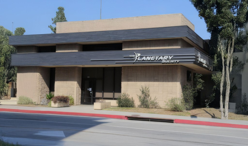
Planetary Society Headquarters in Pasadena (Erik Olsen)
The scientific pedigree of Pasadena can be traced back to notable historical figures, among them the great Richard Feynman, a theoretical physicist known for his work in quantum mechanics and his Nobel Prize-winning contributions to quantum electrodynamics. Feynman was a long-time faculty member at the California Institute of Technology (Caltech) and left an indelible mark on both physics and science education.
In engineering, there is Theodore von Kármán, a Hungarian-American mathematician, aerospace engineer, and physicist, who is remembered for his pioneering work in aerodynamics and astronautics. He was responsible for crucial advances in aerodynamics characterizing supersonic and hypersonic airflow. He is best known for the von Kármán vortex street, a pattern of vortices caused by the unsteady separation of flow of a fluid around a cylinder, which has applications in meteorology, oceanography, and engineering. Von Kármán was also a key figure in the establishment of the Jet Propulsion Laboratory (JPL), which is managed by Caltech (see below).
Cal Tech (Erik Olsen)
In the mid-20th century, Albert Einstein spent several winters at CalTech, further solidifying the city’s reputation as a center of scientific thought. During his stays from 1931 to 1933, Einstein delivered lectures and collaborated with some of the brightest minds in physics, which had a lasting impact on the scientific community in Pasadena and beyond.
Albert Einstein in Pasadena (CalTech Archives)
CalTech itself is a cornerstone of Pasadena’s scientific community. As one of the premier science and engineering institutes globally, it has been at the forefront of numerous breakthroughs in various fields including physics, biology, and engineering. The university is not only a powerhouse of innovation but also a nurturing ground for future scientists, evidenced by its association with 39 Nobel laureates.
Similarly, the Jet Propulsion Laboratory (JPL), which is technically located in La Canada Flintridge (geographically), but has a Pasadena mailing address, is a unique collaboration between NASA and CalTech. JPL is the leading US center for the robotic exploration of the solar system. Its engineers and scientists have been behind some of the most successful interplanetary missions, including the Mars Rover landings, the Juno spacecraft currently exploring Jupiter, and the Voyager probes that have ventured beyond our solar system.
NASA’s Jet Propulsion Laboratory (Erik Olsen)
Further enriching Pasadena’s scientific landscape is the Carnegie Observatories, part of the Carnegie Institution for Science. This establishment has been a pivotal site for astronomical discoveries since the early 20th century. Today, it continues to push the boundaries of astronomical science by managing some of the most advanced telescopes in the world and conducting cutting-edge research in cosmology and astrophysics.
Jupiter as captured by NASA JPL’s Juno spacecraft (NASA/JPL-Caltech/SwRI/MSSS/David Marriott)
Though in the mountains above Pasadena, the Mt. Wilson Observatory, founded by George Ellery Hale, was home to some of the world’s most powerful telescopes in the early 20th century, including the 60-inch and 100-inch Hooker telescopes. (See our feature). These instruments were integral to groundbreaking discoveries, such as Edwin Hubble’s revelation of the expanding universe, which was supported by data from Mt. Wilson’s telescopes.
The Planetary Society, also headquartered in Pasadena, adds to the city’s scientific aura. Co-founded by Carl Sagan, Bruce Murray, and Louis Friedman in 1980, this nonprofit organization advocates for space science and exploration. It engages the public and global community in space missions and the search for extraterrestrial life, demonstrating the city’s commitment to fostering a broader public understanding of science.
Mt. Wilson Observatory (Erik Olsen)
Pasadena’s prowess in scientific innovation is further amplified by the presence of numerous high-tech companies and startups that reside in the city. These range from aerospace giants to biotech firms, many of which collaborate closely with local institutions like CalTech and JPL. Moreover, incubators such as IdeaLab and Honeybee Robotics (there are numerous robotics companies…which I think we will do a stand alone story about in the future) have been instrumental in fostering a culture of innovation and entrepreneurship in the city. Founded in 1996 by Bill Gross, IdeaLab has helped launch companies that have had significant impacts on technology and science, from energy solutions to internet technologies.
Pasadena’s status as a city of science is not just rooted in its institutions but also in its history and the ongoing contributions of its residents and thinkers. The city continues to be a fertile ground for scientific discovery and technological innovation, reflecting a deep-seated culture that celebrates curiosity and the pursuit of knowledge. This environment not only attracts some of the brightest minds from around the globe but also supports them in pushing the boundaries of what is possible, making Pasadena a true city of science.
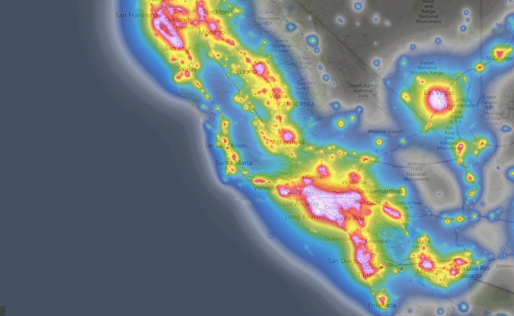
Despite its vast expanse (over 163,000 square miles) California offers surprisingly few places where one can truly gaze upon the night sky in all its glory. Urban light pollution has dimmed the stars across much of the state, making it a rare treat to see more than a handful of celestial points on a clear night. In California’s largest metropolitan areas, like Los Angeles and the Bay Area, the glow from light pollution is so intense that the Milky Way is almost entirely washed out, leaving just the brightest planets and stars visible.
Of course, this is not just a California problem. It’s a sobering reality that underscores a serious global issue: as of 2016, due to artificial lighting, about one-third of humanity could no longer see the Milky Way. Yikes. The problem has only worsened as many cities switch to LED lighting. While LEDs have revolutionized how we light our world and reduced the cost of illumination compared to incandescent bulbs, they have also diminished our ability to see the stars.
Light pollution in Los Angeles as seen from Angeles National Forest (Photo: Erik Olsen)
All that light at night also messes with our lives, interfering with circadian rhythms, leading to sleep disorders, increased stress, and potential long-term health issues such as obesity and cardiovascular disease, according to studies. Artificial light also disrupts ecosystems, affecting nocturnal wildlife by altering their natural behaviors and migration patterns, and can lead to decreased biodiversity. In fact, scientific evidence suggests that artificial light at night has negative and deadly effects on many creatures, including amphibians, reptiles, birds, mammals, insects, and plants.
Dark parks in California offer a refuge from light pollution, providing a glimpse into the cosmos that most urban dwellers rarely experience. These parks are sanctuaries for stargazers, astronomers, and anyone longing to witness the majesty of the night sky. Spend a night camping in the Eastern Sierra, and you will know what I mean. There are few experiences in the natural world as profound as gazing into a blanket of millions and billions of stars and pondering the number of other worlds that might exist in the cosmos (it’s pretty much guaranteed there’s more than one, more than just us).
If only there was an organized effort to create and protect areas where darkness reigns. Enter the DarkSky International.
DarkSky International (previously the International Dark-Sky Association), founded in 1988, is dedicated to combating light pollution and preserving night skies through advocacy, education, and promotion of responsible outdoor lighting practices. They designate Dark Sky Places, including parks, reserves, and communities that meet rigorous lighting standards. As of now, there are just two designated Dark Sky Parks in California (see below) and over 130 across the United States. The IDA also works with policymakers to develop lighting regulations, supports scientific research on light pollution, and raises public awareness about the benefits of preserving dark skies for human health, wildlife, and the environment.
Death Valley National Park (Photo: NPS)
Dark skies are categorized using the Bortle Dark-Sky Scale, a system developed by amateur astronomer John E. Bortle to measure how much light pollution affects the visibility of stars and celestial objects. The scale ranges from Class 1, where the sky is pristine and free from artificial light, to Class 9, where the glow of urban lights makes it nearly impossible to see even the brightest stars. In a Bortle Class 1 sky, found in the most remote wilderness areas, you can see the Milky Way as a bright, detailed arc across the sky, along with countless stars and deep-sky objects. By contrast, in a Bortle Class 9 sky, such as in the heart of Los Angeles or New York City, only the moon, a few planets, and a handful of the brightest stars are visible. This scale offers a standardized way for scientists, conservationists, and amateur stargazers to assess the impact of artificial lighting and advocate for the preservation of natural darkness.
The night sky has always been a source of wonder and inspiration. For centuries, humans have looked up at the stars to navigate, tell time, and dream. Dark skies allow us to see celestial phenomena such as meteor showers, the Milky Way, and distant planets. They also foster a connection to the universe, reminding us of our place in a vast and mysterious cosmos. Beyond their aesthetic and inspirational value, dark skies have practical benefits too. They aid scientific research, support wildlife, and even improve human health by regulating our circadian rhythms, say researchers.
California light pollution map.
Advances in technology have revolutionized astrophotography, enabling photographers to capture the night sky in unprecedented detail. High-sensitivity digital cameras, sophisticated telescopes, and powerful image processing software allow for breathtakingly detailed images of celestial phenomena, from the intricate structures of distant galaxies to the ethereal glow of the Milky Way. These advancements have also made time-lapse photography more accessible, leading to a surge in mesmerizing time-lapse videos of the night sky. These videos, widely shared online (I’ve watched scores of them), showcase the dynamic beauty of the cosmos as stars and planets traverse the heavens. They offer viewers an immersive experience that reveals the universe’s grandeur and motion in a way static images cannot. This booming genre draws in audiences and encourages a deeper appreciation for the night sky, as well as the technology that makes stunning visual storytelling possible. Which raises an odd and unsettling question: what does it mean when we can have a better experience of the night sky by looking at a screen than by looking up at the sky itself?
For a glimpse into the latest in astrophotography, the Milky Way Photographer of the Year awards showcase some of the genre’s best work. Now in its seventh year, the competition by Capture the Atlas highlights 25 stunning images selected from over 5,000 entries, offering breathtaking views of our star-studded galaxy from around the world.
But all is not lost dear California friends. Outside the blazing urban megalopolises of Los Angeles/San Diego and San Francisco/San Jose, California boasts numerous places where visitors can escape the pervasive glow of artificial light. Here are a few of the best:
1. Death Valley National Park: Known for its extreme conditions and vast desert landscapes, Death Valley is one of the darkest places in the United States. The park is one of the two designated dark parks in California and the only one in the state classified as a Gold Tier Dark Sky Park. Its remote location and low humidity create ideal conditions for stargazing.The top ranger suggestions for star gazing locations in Death Valley National Park are: Mesquite Flat Sand Dunes, Harmony Borax Works, Badwater Basin and Ubehebe Crater.
2. Joshua Tree National Park: Famous for its unique rock formations and Joshua trees, this park is also a haven for astronomy enthusiasts. This is the second of California’s official dark parks. The park’s rugged terrain and minimal light pollution offer excellent visibility of the night sky. There are four designated stargazing areas in the park. They are the parking lots of Quail Springs, Hidden Valley, Cap Rock, and Ryan Mountain.
Night skies ablaze with stars and the Milky Way in Joshua Tree National Park (Unsplash)
4. Mount Shasta: If you’re able to go further north, Mount Shasta’s high elevation and clear skies make it a prime spot for observing the stars. The area’s natural beauty adds to the experience of a night under the stars. Everitt Vista Point and Bunny Flat at Mt. Shasta are prime spots for stargazing, along with Lake Siskiyou, Somes Bar, and Shafter Campground. Medicine Lake, near Lava Beds National Monument, also shines in this celestial line-up. Lake Siskiyou offers stunning reflections of the night sky, while Somes Bar and Shafter Campground are known for minimal light pollution and excellent visibility.
5. Pfeiffer Big Sur State Park: Stretching along the central coast, this park offers stunning views of the Pacific Ocean and a dark sky backdrop perfect for stargazing. The park’s coastal location can provide unique opportunities to see the stars reflected in the ocean below.
6. Mount Wilson Observatory: Perched atop a 1,740-meter peak in the San Gabriel Mountains, the Mount Wilson Observatory in Southern California, founded in 1904, boasts some of the largest telescopes available for public use. While primarily an educational venue, it offers an exceptional stargazing experience and a chance to delve into astronomy, appealing to both enthusiasts and experts. It’s just above Los Angeles, so, yeah, the skies aren’t that clear, but we have seen the Milky Way up there before. The observatory provides guided and self-guided tours year-round, making it an ideal destination for learning about the cosmos.
7. Oasis. Said to be the darkest place in California, this tiny little farming town tucked in between Death Valley National Park and the Nevada state line is the gateway to some of the best night gazing skies in the California desert. There’s a whole lot of wild area to the south, between Oasis and Ubehebe Crater in DVNP, that boasts skies as dark as any in the United States.
Photo: NASA
Dark parks in California, like Death Valley National Park and Anza-Borrego Desert State Park, offer incredible opportunities to reflect on your place in the cosmos. Beneath the inky blackness of a truly dark sky, the Milky Way stretches across the heavens in astonishing detail, and countless stars shimmer with a clarity that feels almost unreal. Just think about this for a moment: The Milky Way galaxy is home to an estimated 100 to 400 billion stars. And that’s just one galaxy! There are estimated to be between 100 billion and 2 trillion other galaxies out there. I mean, what?! It’s a scale so vast it’s almost impossible to comprehend.
And that’s what makes light pollution so sad and tragic. While we gain comfort and protection in our cities, the light we generate robs us of the chance to truly grasp our place in the universe. We are so small, and yet, as far as we know, we’re the only life out there. That’s a lot more thought-provoking than any Marvel movie (no offense to Marvel fans).
It’s true that the profound experience of stargazing fosters a deeper connection to the natural world and our place within it, reminding us of the wonder and mystery that lie beyond our planet. These are important things to remember. We owe it to ourselves to occasionally step away from the glow of our homes and cities and stand beneath a truly dark sky, where the universe stretches out above in a breathtaking display. In moments of reflection, we appreciate the invaluable gift of darkness, which not only preserves the nocturnal environment but also fuels our curiosity and sense of wonder—just as it has for our ancestors for thousands of years. By celebrating and protecting these dark parks, we ensure that future generations can continue to gaze up in awe, finding inspiration in the endless expanse of the cosmos.