In early 1934, Southern California experienced one of the most tragic and devastating natural disasters in its history as a populated region: the Los Angeles flood of 1934. This flood, largely forgotten today outside of the areas directly affected, struck La Crescenta, Montrose, and other foothill communities with devastating force, reshaping not just the landscape but the way California approached flood management and disaster preparedness. It was one of the deadliest floods in Los Angeles history.
The catastrophe took shape in early January after a period of intense rainfall, likely the product of an atmospheric river, a weather phenomenon that can deliver extreme, concentrated rainfall over a short period. In this case, a series of storms in early 1934 carried moisture from the Pacific Ocean directly into Southern California. The storms brought unusually heavy rain to the region, especially to the steep, fire-scarred San Gabriel Mountains.
Nearly 12 inches of rain poured over the foothills in a span of a few days, saturating the steep slopes of the San Gabriel Mountains. The natural landscape was already vulnerable, scarred by wildfires that had burned through the mountains in recent years, leaving slopes exposed and unable to hold the sudden deluge. At this time, the practice of fire suppression had only just begun, meaning that the region’s dry, chaparral-covered mountainsides were naturally prone to burns, which often created perfect conditions for flash floods in winter. Once the rainfall reached a critical level, water, mud, and debris barreled down the mountains, channeled by steep canyons that funneled the destructive flow toward the communities below.
A worker digs out a car and the remains of a home on Glenada Ave. in Montrose. (LA Times)
La Crescenta and Montrose were hit hardest, with residents astonished by walls of mud and rock rushing down their streets. Homes were swept from their foundations; trees, rocks, and debris clogged roadways, and massive boulders tumbled down, crushing cars, smashing into homes and rolling into the middle of once-busy streets. The disaster destroyed over 400 homes and claimed dozens of lives, and numerous people were injured. The streets were piled with silt and debris, several feet thick, which made rescue efforts nearly impossible at first. Additionally, infrastructure like power lines and bridges was obliterated, leaving the communities isolated and in darkness. The floodwaters, swollen with debris, rushed into homes, sweeping families out into the chaos, while cars and buildings alike were left buried or carried off entirely.
Believing it to be a secure shelter for the night, a dozen people took refuge in the local American Legion Post 288. Tragically, the building lay squarely in the path of a powerful debris flow that swept down from Pickens Canyon. The force of the flood shattered the hall’s walls, filling it with thick mud that buried everyone inside before surging on its destructive path. Today, a modest memorial honors those lost to the 1934 flood, overlooking the site of the former hall, which has since been converted into part of the flood control infrastructure.
American Legion Hall damaged by flood and mudslide, La Crescenta-Montrose, 1934 (LA Times)
In the aftermath of the tragedy, local and state governments were forced to confront the region’s vulnerability to such floods. At that time, Los Angeles was in the throes of rapid expansion, with more people moving to suburban areas near the San Gabriel Mountains. The flood, along with an even more destructive one in 1938, firmly swayed public opinion toward a comprehensive flood control strategy. The concrete channels that cut through Los Angeles today are part of this system, designed to swiftly carry water past the city and out to the ocean. brought a clear message: these communities needed better protection. As a result, California embarked on an ambitious flood control plan that would shape Los Angeles County’s infrastructure for decades. Engineers and city planners constructed a network of dams, basins, and concrete channels, including structures like the Big Tujunga Dam, to control water flow from the mountains. The Los Angeles River was channeled and paved, transforming it from a meandering, unpredictable river into the hard-lined, brutalist urban waterway we see today. The Arroyo Seco and other channels were also developed as part of this system to divert stormwater, preventing future flood damage in surrounding communities.
People survey the damage to their cars and roads in the aftermath of the flood. (LA Times)
Over the years, this engineering effort proved largely effective in preventing a recurrence of the devastation that struck La Crescenta and Montrose. However, modern critics argue that these concrete channels, while functional, have disconnected Los Angeles from its natural water systems, affecting both wildlife habitats and the local ecosystem. In recent years, the focus has shifted toward exploring more sustainable flood management techniques, with an eye toward revitalizing some of the natural waterways. This includes restoring parts of the Los Angeles River with green spaces, enhancing biodiversity, and creating flood basins that can handle overflow while supporting ecosystems. In this way, the 1934 flood has left a long-lasting impact, as it continues to influence flood control policies and urban planning in the region.
Mud, rocks, and wrecked cars littered Montrose Avenue in Montrose after the New Year’s flooding. (LA Times)
Today, with climate change bringing more extreme weather, Los Angeles is once again reflecting on its flood infrastructure. The LA River Restoration Master Plan is an ambitious project aimed at transforming the Los Angeles River from a concrete flood channel back into a vibrant, naturalized waterway that serves as a green space for local communities. The plan envisions revitalizing the river’s ecosystems, improving water quality, and creating public parks, walking trails, and recreation areas along the river’s 51-mile stretch. By reconnecting neighborhoods and restoring wildlife habitats, it seeks to bring nature back into the urban core. However, the plan comes with significant challenges, including an estimated cost of up to $1.5 billion and complex engineering demands to ensure flood safety while restoring the river’s natural flow and ecology.
Rendering of a section of the LA River part of the Los Angeles River Revitalization Master Plan (Wenk Associates)
The 1934 flood serves as a sobering reminder of the dangers posed by sudden, intense rainfall in fire-prone mountainous regions. As California experiences more intense wildfire seasons, the cycle of fire followed by flood continues to be a significant threat. The legacy of the Los Angeles flood of 1934 underscores the delicate balance required in managing natural landscapes and urban expansion and remains a critical part of understanding how communities can—and must—adapt to an unpredictable climate future.
Update (February 2025): The Ivanpah Solar Electric Generating System, once a milestone in renewable energy, now faces possible closure. Pacific Gas & Electric has agreed to terminate its contracts, citing the higher cost of Ivanpah’s solar-thermal technology compared to photovoltaics. If approved, two of the plant’s three units could shut down by 2026. Southern California Edison is also considering a contract buyout, adding to uncertainty. Environmental concerns, including bird and tortoise deaths from intense solar radiation, have further complicated Ivanpah’s legacy, reflecting the challenges of large-scale clean energy projects.
In the heart of the Mojave Desert, a glittering sea of mirrors sprawls across 3,500 acres, harnessing the relentless desert sun to power homes and businesses across California. As you drive to or from Las Vegas to the West, the facility rises from the desert, resembling an alien spaceport in the distance. From the air, passengers on flights over the desert can easily spot the plant, with its three towering structures gleaming nearly as brilliantly as the sun.
This ambitious undertaking, known as the Ivanpah Solar Electric Generating System, stands as one of the largest concentrated solar power (CSP) plants in the world. Since its completion in 2014, Ivanpah has been celebrated as a major milestone in renewable energy innovation, while also facing considerable scrutiny and challenges.
The idea behind Ivanpah was born from the vision of BrightSource Energy, led by Arnold Goldman, who was an early pioneer of solar thermal technology. Goldman had previously been involved with Luz International, a company that attempted similar solar ventures in the 1980s. Those early projects struggled due to high costs and limited efficiency, eventually falling victim to the market forces of low fossil fuel prices and a lack of policy support. But by the mid-2000s, the winds had shifted. California, driven by its Renewable Portfolio Standard (RPS), began pushing aggressively for renewable energy sources, setting ambitious targets that mandated utilities procure a large percentage of their electricity from clean sources. This provided fertile ground for a revived effort in concentrated solar power.
Ivanpah Solar Power Facility, a glittering sea of mirrors sprawls across 3,500 acres, harnessing the relentless desert sun to power homes and businesses across California. (Erik Olsen)
With significant financial backing from NRG Energy, Google—which has a strong interest in promoting renewable energy as part of its sustainability goals—and the U.S. Department of Energy (which provided a $1.6 billion loan guarantee), the Ivanpah project broke ground in 2010 and began operation in 2014. By its completion, it had become a landmark renewable energy installation—a bold attempt to demonstrate the viability of CSP technology at scale, with a capacity of 392 megawatts (MW), enough to power around 140,000 homes at peak production.
Ivanpah’s CSP technology differs significantly from the more common photovoltaic (PV) solar panels that typically sprawl across rooftops and solar farms. Instead of directly converting sunlight into electricity, Ivanpah employs a central tower system that uses concentrated solar power to generate steam. The facility harnesses the reflections of 173,500 heliostats (large mirrors) spread across the desert floor, each of which tracks the sun throughout the day using computer algorithms, reflecting sunlight onto a central receiver at the top of Ivanpah’s three 450-foot towers.
Photovoltaic solar array in the Mojave Desert in California (Erik Olsen)
Inside these towers, the intense, concentrated sunlight heats water to temperatures of over 1,000°F (537°C). This heat turns water into steam, which drives turbines to generate electricity. This process—turning solar energy into heat, then into steam, and finally into electricity—requires multiple stages of energy conversion, introducing inefficiencies along the way. While innovative, these conversions come with inherent energy losses that ultimately affect overall efficiency. Some of these inefficiencies and energy losses were unanticipated, demonstrating the complexities of scaling concentrated solar power to this level.
The theoretical efficiency of CSP systems like Ivanpah is generally around 15-20%. By comparison, modern PV panels convert sunlight directly into electricity, achieving efficiencies of 15-22%, with some high-end models exceeding 25%. The direct conversion of sunlight by PV systems avoids the multiple stages of transformation needed by CSP, making PV generally more efficient and cost-effective. That is not to say the project was not an unworthwhile effort, just that it has not yet met the early expectations for the technology.
Ivanpah Solar Power Facility from an airplane. (Erik Olsen)
While Ivanpah was a leap forward in solar technology, it has faced several challenges, both technical and environmental. One of the first issues arose in the initial years of operation: the plant produced less electricity than anticipated, often falling short of its projected targets. This shortfall was attributed to a combination of technical complications, lower-than-expected solar irradiance, and operational adjustments as engineers sought to optimize the plant’s complex systems.
In addition, Ivanpah relies on natural gas to preheat its boilers in the early morning or during cloudy weather, ensuring the turbines are ready to operate as soon as the sun provides enough energy. This auxiliary use of natural gas has sparked criticism, with some questioning whether Ivanpah can truly be considered a clean, renewable energy source. While the natural gas usage is minimal relative to the plant’s total output, it highlights a practical limitation of CSP systems, which need to overcome the intermittent nature of sunlight.
Environmental impacts have also drawn attention. Ivanpah’s vast array of mirrors produces a phenomenon known as solar flux, a concentrated field of heat that can reach temperatures high enough to injure or kill birds flying through it. Dubbed ‘streamers,’ because of the smoke that comes from their wings when they burn in midair, birds that enter this concentrated beam often die. (Here’s a video about it.) A report from the California Energy Commission refers to what they call a “megatrap,” where birds are drawn to insects that are attracted to the intense light emitted from the towers. This unintended effect on wildlife has been a significant concern for conservation groups, prompting Ivanpah to work on mitigation measures, including testing visual deterrents to keep birds away.
A burned MacGillivray’s Warbler found at the Ivanpah solar plant during a visit by U.S. Fish and Wildlife Service in October 2013. U.S. Fish and Wildlife Service/AP Photo
Moreover, the sheer size of Ivanpah, covering a significant area of desert land, has raised concerns about the impact on local ecosystems. The Mojave Desert is a delicate environment, and constructing such a large facility inevitably affected the flora and fauna, prompting debates about whether renewable energy projects should be balanced with efforts to preserve pristine habitats.
Ivanpah is just one of several large-scale CSP projects around the globe. Another notable example is the Noor Ouarzazate Solar Complex in Morocco, which is one of the largest CSP installations in the world. The Noor Complex uses both parabolic trough and solar tower technologies and, crucially, incorporates molten salt to store heat, allowing it to generate electricity even after the sun has set. The use of molten salt offers several advantages over water-based systems like Ivanpah. Molten salt can retain heat for longer periods, enabling the plant to continue generating power during periods of low sunlight or even after sunset, which greatly improves grid reliability and helps balance energy supply with demand.
The Crescent Dunes Solar Energy Project, once a symbol of cutting-edge solar technology with its 640-foot tower and field of over 10,000 mirrors, now stands as a cautionary tale of ambitious renewable energy efforts. Despite its initial promise, the project was plagued by technical issues and ultimately failed to meet its energy production goals, leading to its closure. (U.S. Department of Energy)
Similarly, the Crescent Dunes project in Nevada was another attempt to utilize molten salt for energy storage. It initially showed promise but struggled with technical setbacks and eventually ceased operation in 2019 due to persistent issues with the molten salt storage system and failure to meet performance expectations. The technology, although innovative, struggled with high maintenance costs, particularly with the heliostat mirrors and salt storage tanks. The company behind Crescent Dunes, SolarReserve, went bankrupt after being sued by NV Energy for failing to meet its contractual obligations.
Despite these setbacks, the project has not been fully decommissioned. ACS Cobra, the Spanish firm involved in its construction, now operates the plant at reduced capacity, mainly delivering energy during peak demand at night. Although Crescent Dunes has never reached its full potential, it continues to produce some electricity for Nevada’s grid, albeit far below the originally planned levels.
Crescent Dunes underscored the challenges associated with large-scale CSP projects, particularly the difficulty of balancing complexity, maintenance, and operational costs. However, the use of molten salt in Crescent Dunes demonstrated the significant potential for improving CSP efficiency through effective thermal storage, highlighting a critical advantage over water-based systems like Ivanpah that lack extensive storage capabilities.
While CSP holds the advantage of potential energy storage—something PV cannot inherently achieve without additional batteries—PV technology has seen a steep decline in cost and significant improvements in efficiency over the past decade. This rapid evolution has made PV panels more attractive, leading to widespread adoption across both utility-scale and residential projects. Hybrid projects, like Phase IV of the Mohammed bin Rashid Al Maktoum Solar Park in Dubai, are now combining PV and CSP technologies to maximize efficiency and output, utilizing each technology’s strengths.
Ivanpah remains operational, continuing to contribute renewable energy to California’s grid.
Photovoltaic solar array in the Mojave Desert in California (Erik Olsen)
Governor Gavin Newsom has commented on the importance of renewable projects like Ivanpah in meeting California’s ambitious clean energy goals. Newsom has praised Ivanpah as a vital component of the state’s effort to transition away from fossil fuels, emphasizing the need for innovative projects to meet California’s target of achieving 100% renewable energy by 2045. He has highlighted the symbolic value of Ivanpah, not only as a source of clean energy but as a testament to California’s leadership in renewable technology and environmental stewardship. Its story is one of both ambition and caution, highlighting the promise of concentrated solar power as well as its practical and environmental limitations. In many ways, Ivanpah serves as a testbed for CSP technology, providing valuable insights into the challenges of scaling such systems to utility-level production. It has also sparked discussions on the role of CSP compared to other forms of renewable energy, especially as battery technology advances to address PV’s storage challenges.
While CSP is unlikely to overtake PV in terms of widespread adoption due to its complexity and cost, it still has a role to play, particularly in regions with intense sunlight and a need for energy storage. The lessons learned at Ivanpah—both the successes and the setbacks—will inform the next generation of solar projects, driving innovation and helping policymakers, engineers, and investors make more informed decisions about the future of renewable energy infrastructure.
Mohammed bin Rashid Al Maktoum Solar Park (Government of Dubai)
California’s solar and renewable energy installations have seen remarkable success in recent years, as the state continues to push toward its ambitious goal of 100% clean electricity by 2045. In 2024, California achieved several milestones that highlight the effectiveness of its clean energy initiatives. For example, the state has more than 35,000 MW of renewable energy capacity already serving the grid, with 16,000 MW added just since 2020. A key component of this growth is the rapid expansion of battery storage, which has become essential for balancing the grid, especially during peak demand times when solar power diminishes in the evening. In 2024 alone, battery storage capacity grew by over 3,000 MW, bringing the total to more than 13,000 MW—a 30% increase in just six months
In addition to storage, new solar projects like the Blythe Solar Power Project, which generates 485 MW of photovoltaic power and adds 387 MW of battery storage, are powering over 145,000 homes, further demonstrating California’s leadership in clean energy development. This continued investment not only strengthens the grid but also ensures resilience during extreme weather events, which have become more frequent due to climate change.
Despite these successes, California still has a long way to go. The state will need to bring an additional 148,000 MW of renewable resources online by 2045 to fully meet its goals. However, with the state’s rapid advancements in storage technology, solar capacity, and governmental support, California is well on its way to achieving a cleaner, more sustainable energy future.
Google arranged the mirrors at Ivanpah to create a tribute to Margaret Hamilton, the pioneering computer scientist who led the software engineering efforts for the Apollo space missions. (Google)
Beyond its role in renewable energy, Ivanpah has also found itself at the intersection of technology and art. One notable example is when Google arranged the mirrors at Ivanpah to create a tribute to Margaret Hamilton, the pioneering computer scientist who led the software engineering efforts for the Apollo space missions. This artistic alignment of mirrors highlighted Ivanpah’s versatility—not just as an engineering marvel for energy generation but also as a symbol of human achievement. The intricate choreography of heliostats to form an image visible from above served as a powerful visual homage, merging art, science, and technology in a striking way. Such projects have helped broaden the cultural significance of Ivanpah, presenting it not only as a source of renewable energy but also as an inspirational platform that celebrates human creativity and accomplishment.
The next time you’re driving to Vegas and spot the three massive, sun-like objects glowing in the desert, give a thought to the immense power—and challenges—of harnessing the sun’s energy in such a dramatic way.
Imagine a massive island off the coast of California roughly thrice the size of Maui, a lush and wild place where miniature mammoths once roamed and ancient humans hunted in the shadows of towering trees. This island once existed and it’s called Santarosae, and while it is gone now, it was once a thriving ecosystem, teeming with life. Its story provides a captivating window into the ever-changing natural history of the California coast region.
During the last Ice Age, approximately 20,000 to 25,000 years ago, when sea levels were significantly lower, Santarosae Island was a single, expansive landmass that now comprises most of California’s Channel Islands. As the cooler Pleistocene climate transitioned into the warmer Holocene (the epoch we are in now), the Earth’s oceans heated and expanded. Continental ice sheets and glaciers melted, releasing vast amounts of water and causing sea levels to rise dramatically.
At its peak, Santarosae was massive—four of today’s Channel Islands (San Miguel, Santa Rosa, Santa Cruz, and Anacapa) were all connected into a single landmass. It spanned around 1,500 square miles, making it a significant feature of the Pacific coast landscape. Today, only remnants remain in the form of those four separate islands, but evidence of Santarosae’s ancient past continues to reveal itself to scientists.
Map depicting the reconstructed geography of Santarosae.
Anacapa was the first to break away, around 10,300 to 10,900 years ago, as rising waters gradually submerged the narrow isthmus that once connected it to the rest of Santarosae. This slow disintegration of the super island was witnessed by the humans already inhabiting the region. Having arrived between 12,710 and 13,010 years ago, possibly even earlier, these early settlers likely traveled by boat, following the “kelp highway“—a rich, coastal ecosystem of underwater seaweed forests stretching from northern Japan and Kamchatka, along the southern shores of Beringia, down the Pacific Northwest, and into Baja California. For these early explorers, Santarosae would have appeared as a land of abundant resources.
One of the island’s most captivating features was its population of pygmy mammoths, found exclusively on Santarosae. Standing between 4.5 to 7 feet tall at the shoulder and weighing around 2,000 pounds, these miniaturized versions of mainland Columbian mammoths were about the size of a large horse and evolved to suit their isolated island habitat (see our story on the island biogeography of the Channel Islands). The reasons for their dwarfism stem from a phenomenon called island rule, where species on islands often shrink due to limited resources and isolation, as well as a shortage of predators. Despite their smaller size, these island-dwelling mammoths likely shared many characteristics with their larger relatives, including a similar body shape, short fur, and a large head. These mammoths roamed Santarosae until they disappeared around 13,000 years ago, coinciding with both climate changes and the arrival of humans.
Pygmy Mammoth excavation on the Channel Islands (NPS)
The first discovery of “elephant” remains on Santa Rosa Island was reported in 1873. Over time, additional excavations provided insight into the island’s mammoth population, which gradually became smaller over generations, eventually disappearing at the end of the Pleistocene. Notably, paleontological digs conducted on Santa Rosa Island in 1927 and 1928 unearthed the remains of a new species, Mammuthus exilis. In the 1940s and 1950s, Philip Orr of the Santa Barbara Museum of Natural History recovered further specimens while conducting archaeological and geological work on the island.
Most pygmy mammoth remains have been discovered on Santa Rosa and San Miguel Islands, with fewer finds from Santa Cruz Island and even fewer from San Nicolas Island, which lies outside the Channel Islands National Park.
Santarosae was not just a wilderness for megafauna—it was home to some of the earliest known human settlers in North America. Archaeological discoveries, such as the remains of a 13,000-year-old woman unearthed on Santa Rosa Island, point to a sophisticated maritime culture. These ancient humans, likely ancestors of the Chumash people, navigated the waters around Santarosae in plank canoes, hunting seals, birds, and fish, while gathering plants and shellfish.
Archaeologists excavate a anthropological site at the Channel Islands (NPS)
The island provided ample resources, but it wasn’t isolated from the rest of the world. The people of Santarosae were part of a complex trade network that stretched across the California coast. Evidence of these connections can be seen in the tools and materials found on the island, some of which came from distant sources. As sea levels rose, however, these early inhabitants had to adapt to the shrinking island, eventually migrating to the mainland.
Santarosae’s landscape during the Ice Age was strikingly different from what we see on today’s Channel Islands. Dense forests of pines, oaks, and other vegetation covered much of the island, supporting a rich diversity of life. The island’s topography included hills, valleys, and freshwater sources, offering an ideal environment for both humans and animals. As the climate warmed and sea levels rose, the island’s ecology shifted. Forests retreated, and the landscape began to resemble the wind-swept, scrubby terrain seen on the modern Channel Islands.
Anacapa Island today (Erik Olsen)
The rise in sea levels didn’t just transform the landscape; it also altered the ecosystems. Many of the animals, like the pygmy mammoths, couldn’t survive the changing conditions (or human hunters), while new species adapted to the shrinking landmass. Birds, insects, and plant species began to dominate, and the island ecosystems became more specialized.
Today, the remnants of Santarosae offer an invaluable window into the past. The Channel Islands National Park protects much of the area, and researchers continue to uncover clues about the island’s history. Ongoing archaeological digs and ecological studies on the islands help piece together the story of Santarosae’s people, animals, and landscape.
Tourists now enjoy the natural beauty of the Channel Islands (Erik Olsen)
For those who visit the Channel Islands today, it’s hard to imagine the ancient world of Santarosae—a much larger island teeming with life. But the remnants of this lost island still hold secrets waiting to be uncovered, offering a fascinating glimpse into California’s distant past and a reminder of how the forces of nature continually reshape our world.
Though Santarosae is now submerged, its influence is still a significant part of California’s natural history.
California Market Squid. The animal’s skin is covered with thousands of tiny chromatophores that change color and can dramatically transform the squid’s appearance.
The ocean’s depths are filled with mysterious and fascinating creatures, but few have made quite the splash in both nature and culture as the squid. Sleek, swift, and full of surprises, these little cephalopods are not only culinary favorites but also masters of survival in the ever-changing marine world.
The California market squid, scientifically known as Doryteuthis opalescens, is an integral component of the marine ecosystem and significantly contributes to California’s economy. Although these cephalopods may not captivate public imagination as vividly as their larger, more enigmatic cousins like the giant squid, or even California’s charismatic Two-Spotted Octopus, their role is both ecologically and economically invaluable.
In appearance, Doryteuthis opalescens is a relatively small squid, typically measuring up to a foot in length. It is characterized by its elongated tubular body and mantle. It has a set of eight shorter arms and two longer tentacles, all equipped with suckers for prey capture. The skin of the California market squid contains specialized pigment cells called chromatophores, which allow it to change color in mesmerizing ways. This is not just a display of beauty; the capability is used for camouflage from predators and likely communication with other squids. Their complex eyes are especially remarkable. These structures are highly developed and contain a lens that can focus, similar to the optical system in the human eye, allowing the squid to have keen vision—a trait essential for both hunting and avoiding predators.
The squid’s eyes contain a lens that can focus, similar to the optical system in the human eye, allowing the squid to have keen vision. (Wikipedia)
As for their reproductive habits, the mating and spawning of California market squid generally occur from April to November. The male deposits a spermatophore, or sperm packet, into the female’s mantle cavity. Post-fertilization, the female lays between 200 to 300 eggs, encapsulated in clusters, and attaches them to the substrate on the ocean floor. Neither parent plays a role in the post-fertilization life of these eggs. Both males and females often die shortly after mating, leading to a rather short life span for these creatures, usually between six to nine months.
The feeding behavior of the California market squid is best described as opportunistic. They primarily consume plankton, small fish, and other marine organisms. This diet situates them in a critical role within the food web, serving as both predator to smaller organisms and prey to larger marine animals. Typically, they inhabit depths less than 300 meters and are more active during nighttime, migrating vertically within the water column to follow prey and avoid predators.
Squid vessels at night, lights ablaze, looking for market squid in Monterey Bay. (Photo: CDFW)
Economically, the California market squid has an enormous impact. According to reports, it represents the largest fishery in California by volume. In 2022, commercial landings of market squid totaled 147 million pounds and were valued at $88 million, according to the NOAA Fisheries commercial fishing landings database. The fishery for this particular species accounts for nearly 25% of all commercial fishery landings by weight in the state. The significance of the market squid extends to the international sphere, as a considerable portion of the catch is exported to countries in Europe and Asia. In some years, the squid are abundant, but in other years, they are hard to find. Cyclical changes in ocean conditions can change the productivity of California waters and squid populations plummet. In some particularly bad years, the squid fishing industry suffers.
In California, the Fish and Game Commission collaborates with the Department of Fish and Wildlife to actively manage the market squid fishery in line with federal guidelines and the state’s Market Squid Fishery Management Plan.
California Market Squid (NOAA)
Changes in climate may end up having a major impact on the squid and the fishery. A 2020 paper from Stanford University published in The American Naturalist, details how climate change has likely ushered the squid north in the Gulf of Alaska, perhaps due to rising ocean temperatures causing the squid to move to more suitable habitats. The study highlights how the squid’s migration could impact local ecosystems, where their presence could alter food chains by competing with or preying on native species like young salmon. This research may predict broader marine species shifts in the future. The squid’s populations are also clearly linked to El Niño cycles.
“As climate change progresses, there are bound to be other species like the California market squid that move to more suitable seas,” Mark Denny, the John B. and Jean De Nault Professor in Marine Science at Hopkins Marine Station and senior author on the paper told Stanford’s Earth Matters Magazine. “Investigating what happens to this squid and the ecosystems around them right now will help researchers predict what could happen to other marine life later.”
As mentioned above, given its economic and ecological relevance, there are stringent regulations and monitoring programs in place to ensure sustainable fishing practices. Seasonal closures of the fishery, especially during peak spawning seasons, and restrictions on the type of fishing gear used are examples of such management strategies. The squid is considered a “smart seafood choice” by NOAA. These measures aim to minimize bycatch and preserve the squid population, thereby sustaining the ecological balance within the marine environment.
However, the agency notes: “Short- and long-term changes in the market squid population are poorly understood, The stock has not been assessed so there are no reliable estimates of the population size and the overfished and overfishing status are unknown.”
Despite being delicious, particularly when fried, the California market squid is far more than just an item on a seafood menu. It is a linchpin species that not only contributes to biodiversity in California, but also holds substantial economic value. Its role in the food web as both predator and prey, as well as its economic impact on both the local and global scales, positions it as a vital species deserving of ongoing scientific study and responsible management.
A neighborhood threatened by landslides at Portuguese Bend on Palos Verdes (Erik Olsen)
For decades, geologists and engineers have been aware that the Portuguese Bend region of Palos Verdes is prone to landslides. Early maps and aerial surveys from the 1930s show continuous movement from the upper hills towards the high cliffs and bluffs that reach the Pacific Ocean.
Over the years, with a few exceptions, the ground movement was relatively slow, averaging about a foot per year. However, after the intense rains of the past year or two, the land is now shifting much more rapidly—up to 9 to 12 inches per week—plunging neighborhoods and communities built on this unstable terrain into panic and disarray. This accelerated movement has caused irreparable damage to some homes and led California to declare a state of emergency.
Aerial survey from the 1930s showing landslide potential at Portuguese Bend in Palos Verdes (Ranch Palos Verdes city government)
People have been allowed to build homes at Portuguese Bend largely due to a combination of historical oversight, demand for coastal real estate, and limited understanding of the area’s geologic instability when development first began. In the 1950s and 1960s, when much of the residential development in the area took place, there was less awareness and fewer regulations regarding the risks of building on unstable ground. Additionally, the picturesque coastal views and desirable location made Portuguese Bend an attractive area for developers and homeowners. Despite known landslide risks, building permits were often issued because of insufficient geotechnical assessments, political and economic pressures, and a lack of stringent land-use policies at the time. Over the years, as the understanding of the area’s geologic hazards has grown, there have been more restrictions and efforts to mitigate risks, but many homes already exist on land prone to movement.
The situation is similar to building homes in fire-prone areas – well-known to Californians, of course – within the so-called Wildland-Urban Interface (WUI), where human development meets and mixes with natural landscapes, creating a high-risk zone for natural disasters.
Small landslide at Portuguese Bend in Palos Verdes (Erik Olsen)
Portuguese Bend is one of the most active landslide zones on the peninsula. Here, the earth moves continuously, almost imperceptibly at times, but the effects are undeniable. The land isn’t just sliding; it’s flowing—like a slow-moving river of rock and dirt—down a natural depression, a sort of bowl or gulch formed by the interplay of tectonic activity and erosion. This gradual yet relentless descent toward the sea is driven by a combination of factors: the underlying geology of ancient marine sediment layers, heavy rainfall, and the constant forces of gravity pulling on the steep slopes. As a result, roads buckle, homes crack, and entire sections of land shift over time.
The geological makeup of Palos Verdes is complex and varied. The most prominent rocks on the Palos Verdes Peninsula, and the most crucial in terms of slope stability, belong to the Miocene Monterey Formation, which we wrote about in a previous article. This formation, over 2,000 feet thick in some areas, has been divided into three distinct members based on their rock types: the Altamira Shale, the Valmonte Diatomite, and the Malaga Mudstone, arranged from oldest to youngest.
Portuguese Bend at Palos Verdes
The Altamira Shale primarily consists of thin-bedded sedimentary rocks formed from layers of clay, interspersed with numerous layers of tuff, or volcanic ash that has largely transformed into weak clays over time. Thick deposits of volcanic ash, laid down millions of years ago, have been compacted into a clay-like material known as bentonite. When bentonite comes into contact with water, it becomes extremely slippery, acting like a natural lubricant. This slippery nature has been a major factor in triggering landslides throughout the Rancho Palos Verdes area, where the land’s stability is continually undermined by these underlying geological conditions.
Another factor contributing to landslides is the region’s tectonic activity. Palos Verdes sits above several active faults, including the Palos Verdes Fault. The movement along these faults exerts stress on the rock formations, leading to fractures and cracks that weaken the slopes. These cracks often become pathways for water to seep into the ground, further destabilizing the already precarious terrain.
The road along the coast at Portuguese Point has been moving for decades, a slow but relentless reminder of the dynamic nature of California’s landscape. (Erik Olsen)
Water plays a crucial role in triggering landslides in this region. Heavy rains, especially those associated with El Niño events like the atmospheric rivers of the last few years, can lead to a rapid increase in groundwater levels. When water infiltrates the ground, it increases the pressure within the soil and rock, reducing the friction that holds everything together. In Palos Verdes, where irrigation, septic systems, and urban development are common, human activities can exacerbate this natural process by altering drainage patterns and increasing water saturation in vulnerable areas. This convergence of natural and human-made factors makes the slopes more prone to sliding, particularly during or after intense rainfall.
To combat this, construction teams have installed a series of dewatering wells and pumps to actively extract groundwater from deep within the hillside. By lowering the water table and reducing the amount of water that saturates the soil, these efforts help to decrease the pressure within the slope and mitigate the risk of further ground movement. This method of dewatering is a crucial element in stabilizing the land, as it helps prevent the soil from becoming too heavy and reduces the lubricating effect that water has on the bentonite clay layers.
Closed road at Portuguese Bend in Palos Verdes (Erik Olsen)
Coastal erosion is another critical factor. The rugged cliffs of Palos Verdes are constantly being eroded by the ocean’s waves, wind, and rain. Over time, wave action undercuts the base of the cliffs, removing the support for the upper layers and leaving them hanging precariously over the ocean. As the base erodes away, the upper cliffs become more susceptible to collapse. When combined with the weakened geology and increased groundwater levels, this coastal erosion sets the stage for dramatic landslides.
Portuguese Point cliffs are part of the constant coastal erosion process at Palos Verdes aerial photo (Erik Olsen)
Recent studies are shedding new light on why landslides in Palos Verdes continue to be a concern. Geologists are now using advanced technologies, such as ground-penetrating radar and satellite imagery, to better understand the underground conditions that contribute to landslides. A study from the University of California, Los Angeles, has explored how even minor shifts in groundwater levels, exacerbated by climate change and increasingly unpredictable weather patterns, can tip the balance and trigger significant slope failures. This research emphasizes that it’s not just the obvious heavy rainfall events that pose a threat; subtle changes in water content due to human irrigation, drought, or even slight variations in precipitation can also destabilize these slopes over time.
Moreover, new geological mapping and subsurface studies have provided a clearer picture of the fault lines and the fractured rock layers beneath Palos Verdes. These studies suggest that the interaction between multiple fault zones may be more significant than previously thought, potentially increasing the region’s susceptibility to movement. Understanding these interactions is crucial for predicting future landslides and developing mitigation strategies.
But in the end, nature will likely have the final say.
Portuguese Bend in Palos Verdes (Erik Olsen)
The picture that emerges from these studies is one of a region where natural geological processes and human activities are in a delicate balance. It’s an ongoing fight that really offers a precarious vision of the future for residents and others who use the area for recreation. The weak rock formations, intersecting fault lines, and relentless coastal erosion create an environment where the land is always moving and on the brink of collapse. Add to this the unpredictable impacts of climate change, which can bring more intense storms and alter precipitation patterns, and it becomes clear why Palos Verdes is so prone to landslides.
Efforts to mitigate the risk are ongoing. Local governments and geologists are working to develop more effective monitoring systems and better land-use planning guidelines to manage development in these sensitive areas. Understanding the complex geology and hydrology of Palos Verdes is critical to preventing future disasters and protecting the communities that call this beautiful but unstable coastline home.
California’s Monterey Formation is one of the most fascinating geological formations in the United States. Stretching along the California coast from San Francisco to Los Angeles, this formation is notable for its incredible diversity of siliceous rocks—rocks rich in silica, such as shale, chert, diatomite, and porcelanite. While these rocks are interesting to geologists, the Monterey Formation is also significant for its potential to explain the origins of petroleum deposits that have fueled California’s economy for over a century. NASA’s Jet Propulsion Laboratory once called it “California’s primary petroleum source rock.”
Fracture network of joints and cross-joints exposed on bedding surface of siliceous shale. Note linked, larger-aperture fracture in center with oxidation rim. Montaña de Oro State Park. (NASA JPL)
At the heart of the Monterey Formation’s geology is the unique composition of many different types of rock that come together in such a way that they create an ideal environment for trapping oil. The intricate layering of organic-rich shales, siliceous rocks, carbonates, and diatomites forms a complex network of porous and permeable spaces, allowing oil to migrate into these reservoirs. Over time, these rocks act like natural sponges, effectively capturing and holding large quantities of oil within their formations, making the Monterey Formation one of California’s most significant petroleum sources. It is estimated that over 38 billion barrels of oil have been produced to date from fields whose source rock is the Monterey.
Diatomite, a light, porous rock formed from the fossilized remains of diatoms, is a dominant feature. Diatoms, microscopic algae with silica-based cell walls, thrived in nutrient-rich waters, leading to the thick layers of sediments that later became diatomite. Chert, another key rock type in the formation, is formed from the recrystallization of biogenic silica, adding to the complexity of the geological record. Interspersed with these are organic-rich shales, which contain substantial amounts of organic material called kerogen. Over millions of years, kerogen undergoes a biological transformation becoming the oil and gas that now serve as the backbone of California’s petroleum industry (see our story on the history of the Long Beach oil industry).
Diatoms (Wikipedia)
The Monterey Formation displays a fascinating and unusual mixture of geological deposits, from deep ocean basins to shallow continental shelves. During the Miocene, upwelling currents along the California coast brought nutrient-rich waters to the surface, fostering high biological productivity and depositing vast amounts of biogenic silica, a form of silicon dioxide (SiO₂) that is produced by living organisms. Periods of fluctuating sea levels, driven by climate changes and tectonic shifts, further shaped the environment. During low sea levels, parts of the continental shelf were exposed, allowing for erosion from wind and sun. These would shift to periods of high sea levels, which allowed for denser, deep-water sedimentation. In some layers, the presence of evaporites—minerals that form from the evaporation of water—suggests extensive episodes of arid conditions, similar to what we are experiencing now with California’s recurring periods of drought.
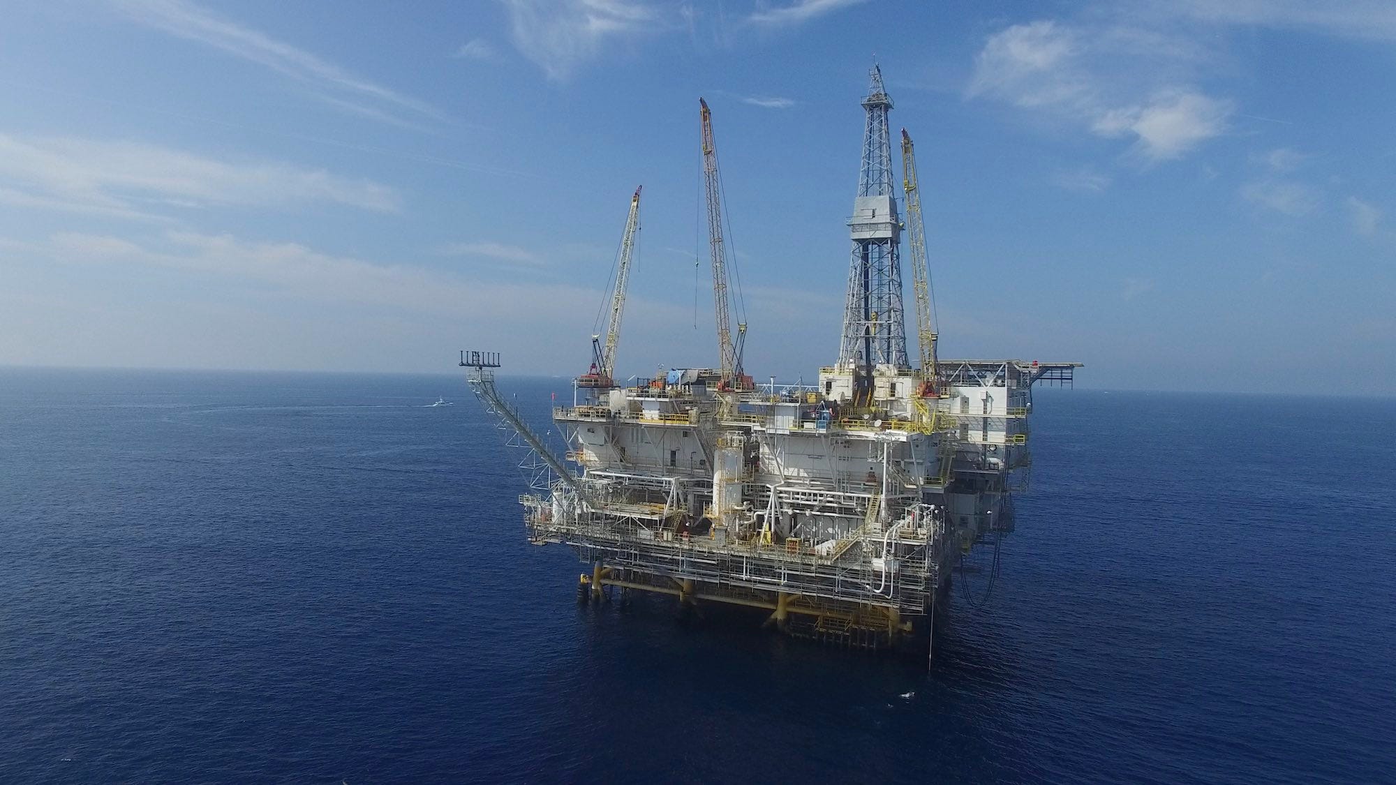
Offshore oil platforms along California’s coast drill into the Monterey Formation, either tapping directly into its fractured shale or extracting oil that has migrated into more porous sandstone reservoirs. (Photo: Erik Olsen)
Much of the pioneering research on the geology, formation, and unique composition of the Monterey Formation was conducted by the late Robert Garrison, a distinguished professor of oceanography at the University of California, Santa Cruz. Garrison was considered the foremost expert on the Monterey Foundation, and his work was instrumental in revealing how the Monterey Formation’s diatomaceous and phosphatic deposits were shaped by a combination of oceanographic upwelling, climatic shifts, and tectonic activity during the Miocene epoch.
Petroleum geologists find the Monterey Formation especially intriguing because it serves as both a source and a reservoir for oil and gas, allowing them to better understand the processes of oil and gas generation, migration, and accumulation, as well as to develop more efficient extraction methods to maximize its economic potential. They are also quite beautiful. Walk along the beach near Crystal Cove in Orange County, for example, and examples of Monterey Formation rocks abound.
Monterey Formation rocks near Little Corona in Newport Beach (Erik Olsen)
Oil is formed from the remains of ancient marine organisms, such as plankton and algae, that were buried under layers of sediment and subjected to heat and pressure over millions of years, transforming them into hydrocarbons. Some of these hydrocarbons migrated into more permeable rocks, creating substantial oil fields that have been exploited for decades in Southern California. Certain layers of the Monterey Formation, particularly the fractured chert and dolomitic sections, also serve as excellent reservoirs due to their porosity and permeability, allowing them to store oil and gas for long periods of time.
Beyond its geological and economic importance, the Monterey Formation is a treasure trove for paleontologists. Its layers preserve a variety of marine fossils, including diatoms, radiolarians, foraminifera, and coccolithophores. These microfossils offer a detailed look at past ocean conditions, helping scientists reconstruct the climatic and oceanographic history of the Miocene epoch. Additionally, the formation contains fossils of larger marine vertebrates, such as whales, seals, and fish, providing further insight into the ecosystems of ancient oceans.
Microscope image of microfossils and organic matter in Monterey rocks. (Cal State Long Beach)
However, the Monterey Formation is not just a source of knowledge and resources; it also presents challenges, particularly in terms of potential environmental harm and geohazards like landslides. The soft, diatomaceous earth layers within the formation are prone to landslides, especially when water-saturated or fractured by tectonic action. This makes some coastal areas of California, where the Monterey Formation is exposed, particularly vulnerable to slope instability, posing risks for construction and development. Many recent news stories have documented the increasing rate at which the California coast is tumbling into the sea. An excellent recent book on the subject is Rosanna Xia’s California Against the Sea: Visions for Our Vanishing Coastline.
California’s geology is a remarkable mosaic that tells a story of immense geological diversity and dynamic processes. Among its many treasures, the Monterey Formation stands out as a geological marvel—its intricate layers, rich fossil beds, and significant economic potential continue to captivate scientists and researchers from around the world. This unique formation is more than just rock; it is a time capsule that preserves millions of years of Earth’s history, from ancient marine ecosystems to dramatic shifts in climate and tectonic activity. As geologists, paleontologists, and environmental scientists delve deeper into its mysteries, the Monterey Formation reveals invaluable clues about the past while shaping our understanding of California’s ever-evolving landscape. It serves as a profound reminder of the powerful forces that have sculpted one of the most geologically varied regions on the planet and continues to inspire exploration and discovery in the fields of Earth science.
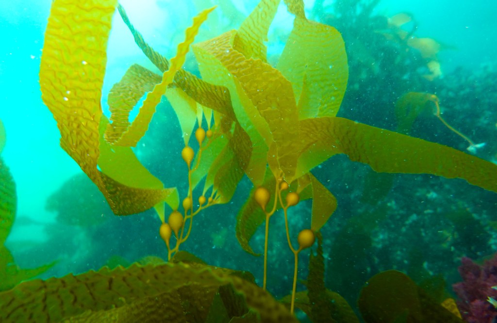
Two centuries ago, the waters off the California coast were home to a vibrant ecosystem of plants and animals. Vast forests of kelp provided habitat for thousands of species of fish and invertebrates. Some of these kelp forests were so dense that light hardly penetrated to the seafloor. But now, along much of the coastline, the kelp is all but gone.
The tragedy here goes far beyond species loss and a troubling decline in overall biodiversity in our coastal waters. Kelp are also great at taking up carbon dioxide from the atmosphere and they help reduce acidification of the oceans, essentially cleaning the water and bringing balance to the entire ecosystem.
Kelp off the coast of Anacapa Island in California’s Channel Islands (Photo: Erik Olsen)
But now, that balance is has been disrupted. A recent study says that California’s bull kelp (Nereocytis luetkeana) forests (one of several species that are endemic here) have declined by 93% in just the last five years.
It’s difficult to fathom the scale of this loss, and we are only beginning to understand what it will mean for the overall health of our coastal waters. When the kelp disappears, the entire complex web of organisms that rely on it for habitat and food is disturbed. That is to say, large swaths of the near-shore California coastal ecosystem depend upon kelp.
So, what is happening? Well, first a little history.
A healthy kelp forest in Channel Islands National Park (NPS)
Two centuries ago, when kelp forests along the coast were so abundant they stretched for hundreds of miles with thick canopies that could be seen at the surface. At the time, urchins existed, but their populations were held in check by sea otters, which have been known to eat 1/4 of their body weight in urchins in a day. But unrestrained hunting by trappers (often Russian and British) in the early 1800s and into the mid-century brought sea otter populations down so low, at one point they were considered extinct in the wild. With the otters gone, urchins flourished and along certain stretches of coast, the kelp disappeared. Remember, this was 200 years ago, long before California was even a state.
Otters have come back to certain stretches of the California coast, especially near Monterey, and in some cases, the kelp has come back. And, in fact, even now, some places around the state, things aren’t nearly so bad. One-third of southern California’s kelp forests are found within Channel Islands National Park and Channel Islands National Marine Sanctuary, where no-take marine reserves prohibit all take of living, geological, or cultural resources. In the reserve, California sheephead, spiny lobsters, and sunflower stars eat sea urchins and keep their population from exploding.
Bust most other regions are not so lucky. And things have gotten even worse. This is where it gets more complicated.
A diver measures kelp growth (Kate Vylet/California Sea Grant)
An intense ocean warming period between 2014 and 2017 is the likely culprit in causing a mass die-off of starfish. Starfish prey on native purple urchins, keeping their numbers in check. With mass numbers of sea stars dead, the urchins proliferated, eating their way through the kelp forests. The result: disaster.
“What we’re seeing now are millions and millions of purple sea urchins, and they’re eating absolutely everything,” said Laura Rogers-Bennett, an environmental scientist with UC Davis Karen C. Drayer Wildlife Health Center and California Department of Fish and Wildlife operating out of the UC Davis Bodega Marine Laboratory. “They can eat through all the anemones, the sponge, all the kelp, the fleshy red algae. They’re even eating through calcified alga and sand.”
The loss of kelp forests in California should be immediately recognized as a major ecological problem to solve, and while some projects are underway to do just that, much more needs to be done.
Several organizations, most of them California-based, are trying to reduce the number of urchins in Southern California. For example, UC Davis researchers are working with Bay Area shellfish company Urchinomics to explore “ranching urchins, removing them from the seafloor and fattening them up to be sold as sushi. Urchins are highly valued by Japanese consumers and are even sold in some California sushi restaurants. One problem is that purple urchins tend to be too small to harvest for human consumption, hence the need to increase their size via aquaculture. But will this be enough to stop the urchin’s march towards environmental saturation? Probably not.
The Bay Foundation in Santa Monica launched a program to restore kelp beds around 150 acres of urchin barrens along the rocky reefs off Palos Verdes. Scientists, recreational divers, and fishermen go down and smash the urchins with small hammers. The effort has shown promise, with kelp growing back in 46 acres of restored reef. Again, this is not nearly enough.
Kelp forest off Palos Verdes Peninsula (Erik Olsen)
Other strategies are outlined in the Sonoma-Mendocino Bull Kelp Recovery Plan, released last June by the Greater Farallones Association and California Department of Fish and Wildlife. It includes measures such as creating a kelp oasis to preserve seed stock and repopulate bull kelp when conditions are conducive to restoration.
This may all be too little too late. We believe state, local and federal agencies should redouble their efforts now to mitigate the loss of kelp in California waters. The implications for further, perhaps total, loss of California’s once-flourishing kelp forests are just too dire and action is required now. As the authors of the report write “it may take decades before the complex biological communities, associates, and the ecosystem services provided by macroalgal [seaweed] forests rebound.”