The recent fires that swept through sections of Los Angeles will be remembered as some of the most destructive natural disasters in the city’s history—a history already marked by earthquakes, floods, and the potential for tsunamis. Yet, even a week later, confusion persists about what happened. Predictably, the finger-pointing has begun, with political opportunism often overshadowing rational analysis. This is, unfortunately, emblematic of our current climate, where facts are sometimes twisted to suit individual agendas. What we need now is a sound, scientific examination of the factors that led to this catastrophe—not just to better prepare for future disasters, but to deepen our understanding of the natural forces that shape our world.
One fact is indisputable: the fires were unusual in their ferocity and destruction. While studies, debates, and expert analyses following the disaster are inevitable, the immediate aftermath offers one clear conclusion—this fires were driven, in large part, by the extraordinary winds that descended on Los Angeles that night. On January 8th, Santa Ana winds roared through the chaparral-covered canyons of the San Gabriel Mountains like a relentless tidal wave of warm air. I witnessed this firsthand, standing outside on my porch as 100-foot trees bent under the gale forces, their massive branches snapped like twigs and flung into streets, homes, and vehicles. A few of them toppled entirely. Having lived in Los Angeles for most of my life, I can confidently say I had never experienced winds of this intensity.

The conditions were ripe for disaster. Southern California had not seen significant rainfall since May, leaving the chaparral bone dry. According to Daniel Swain, a climate scientist at UCLA and the University of California Agriculture and Natural Resources, this year marks either the driest or second-driest start to the rainy season in over a century. Dry chaparral burns quickly, and with the powerful winds driving the flames, the fire transitioned from a wildland blaze to an urban inferno. When the flames reached residential areas, entire neighborhoods of mostly wood-frame homes became fuel for the firestorm. In the lower foothills, it wasn’t just the vegetation burning—it was block after block of homes reduced to ash.
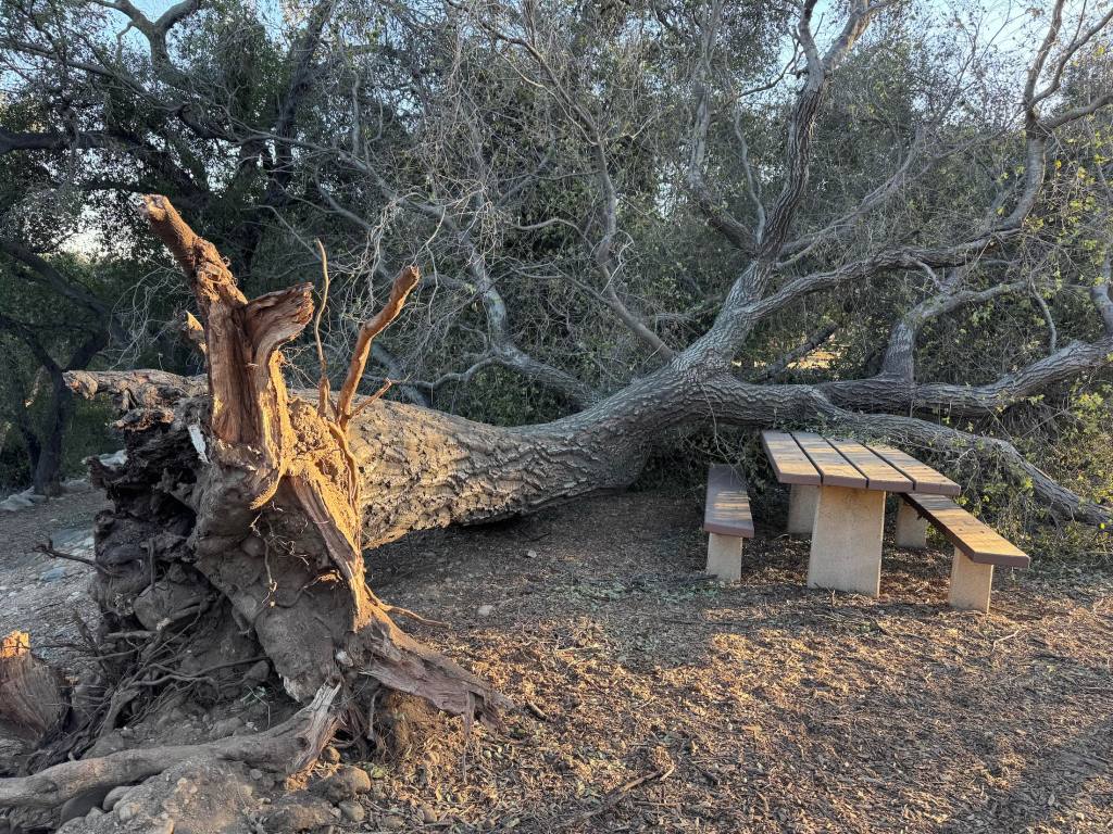
The wind was the true accelerant of this tragedy. Yesterday, I walked through the Hahamongna Watershed Park, formerly known as Oak Grove Park, renamed in the late 20th century to honor the Tongva people. In just 15 minutes, I passed more than a dozen massive oaks—centuries-old trees ripped from the ground, their intricate root systems exposed like nerves. These trees had withstood centuries of Southern California’s extremes—droughts, floods, heat waves—only to be toppled by this extraordinary wind event. Climate change undoubtedly influences fire conditions, but the immediate culprit here was the unrelenting, pulsating winds.
Meteorologists had accurately predicted the intensity of this event, issuing warnings days in advance. Many residents took those warnings seriously, evacuating their homes before the fire reached its peak destruction. While the loss of 25+ lives is tragic, it is worth noting how many lives were saved by timely evacuations—a stark contrast to the devastating loss of life in the Camp Fire in Paradise a few years ago. Though the terrain and infrastructure of the two locations differ, the success of the evacuations in Los Angeles deserves recognition.
The winds of January 8th and 9th were exceptional, even by the standards of Southern California’s fire-prone history. They tore through canyons, uprooted trees, and transformed a wildfire into an urban disaster. Understanding these winds—their causes, their predictability, and their impacts—is essential not only to prevent future tragedies but to grasp the powerful natural forces that define life in Southern California. As the city rebuilds, let us focus on learning from this disaster, guided by science, reason, and a determination to adapt to a future where such events may become increasingly common.

Southern Californians know the winds by many names: the “devil winds,” the “Santa Anas,” or simply the harbingers of fire season. Dry, relentless, and ferocious, Santa Ana winds have long been a defining feature of autumn and winter in the region. This past season, they roared to life with exceptional vigor, whipping through Altadena and the Pacific Palisades, fanning flames that turned neighborhoods into tinderboxes. As these winds carried ash and terror across Southern California, a question lingered in the smoky air: what made this Santa Ana event so severe, and was climate change somehow to blame?

To understand the recent fires, one must first understand the mechanics of the Santa Ana winds. They begin far inland, in the arid Great Basin, a sprawling high-altitude desert region encompassing parts of Nevada, Utah, and eastern California. Here, in the shadow of towering mountain ranges, a high-pressure system often takes hold in the fall and winter. This system is driven by cold, dense air that sinks toward the ground and piles up over the desert. When a contrasting low-pressure system develops offshore over the Pacific Ocean, it creates a steep pressure gradient that propels the cold air westward, toward the coast.
The high-pressure system over the Great Basin in January, which fueled the devastating fires in Los Angeles, was unusual in several ways. While these systems often dominate in the fall and winter, this particular event stood out for its intensity, prolonged duration, and timing. High-pressure systems in the Great Basin drive Santa Ana winds by forcing cold, dense air to sink and flow toward lower-pressure areas along the coast. In this case, the pressure gradient between the Great Basin and the coast was extraordinarily steep, generating winds of unprecedented strength. As the air descended, it warmed through compression, becoming hotter and drier than usual, amplifying fire risks in an already parched landscape.

As this air moves, it descends through mountain passes and canyons, accelerating and compressing as it drops to lower altitudes. This compression heats the air, causing it to become warmer and drier. By the time the winds reach urban areas like Altadena or the Pacific Palisades, they are hot, parched, and moving with hurricane-force gusts. The result is a perfect storm of conditions for wildfire: low humidity, high temperatures, and gale-force winds that can carry embers miles from their source.
In the case of the recent fires, these dynamics played out in particularly dramatic fashion. Winds clocked in at speeds exceeding 70 miles per hour, snapping tree branches and downing power lines—common ignition sources for wildfires.

Purchase stunning art prints of iconic California scenes.
Check out our Etsy store.
The cold air over the Great Basin didn’t appear out of nowhere. Its origins lay in the Arctic, where polar air was funneled southward by a wavering jet stream. The jet stream, a high-altitude ribbon of fast-moving air that encircles the globe, has become increasingly erratic in recent years, a phenomenon many scientists attribute to climate change. The Arctic is warming faster than the rest of the planet, reducing the temperature difference between the poles and the equator. This weakening of the temperature gradient slows the jet stream, allowing it to meander in large, looping patterns. One such loop likely brought Arctic air into the Great Basin, setting the stage for the ferocious winds. While much is known about these patterns, it’s an emerging area of research with compelling evidence but not yet universal consensus.
As these winds swept across Southern California, they encountered vegetation primed for combustion. Years of drought, exacerbated by rising temperatures, had left the region’s chaparral and scrubland desiccated. When embers landed in this brittle fuel, the flames spread with devastating speed, aided by the winds that acted as bellows.
While the direct cause of the fires was likely human—downed power lines or another ignition source—the conditions that turned a spark into an inferno were shaped by the interplay of natural and human-influenced factors. Climate change didn’t create the Santa Ana winds, but it likely amplified their effects. Warmer global temperatures have extended droughts, dried out vegetation, and created longer, more intense fire seasons. Meanwhile, the erratic jet stream may make extreme high-pressure events over the Great Basin more likely, intensifying the winds themselves.
This intersection of natural weather patterns and climate change creates a troubling new normal for Southern California. The Santa Ana winds, once a predictable seasonal nuisance, are now agents of destruction in an era of heightened fire risk. Their devilish power, long mythologized in Southern California lore, is now being reframed as a warning sign of a climate in flux.
As the smoke clears and communities begin to rebuild, the lessons from these fires are stark. Reducing fire risk will require not only better management of power lines and vegetation but also a reckoning with the larger forces at play. The Santa Anas will continue to howl, but their fury need not be a death sentence. To live in harmony with these winds, Californians must confront the deeper currents shaping their world. The question is whether we can act before the next spark ignites the next inferno.