If you’ve recently encountered this Website, welcome. I hope you find something here that feeds your interests and gives you a reason to look a little more closely at the world around you. And if you’ve been here for a while, I’m genuinely grateful you’ve stuck around. What a few years ago as a passion project has slowly turned into something closer to an obsession. It felt like a good moment to pause and explain what this is really about. If I had to choose one or two words, it would be curiosity…and ignorance.
If you spend enough time outside in California, you start to realize how much you don’t know.
Celebrate California’s wild side with our beautifully illustrated wildlife mugs, featuring the state’s most iconic birds and animals. Visit our store and bring a little piece of California nature to your morning coffee.
I often hike in the San Gabriels or the Sierra and see a bird flash across my field of view and think, “What was that?” (California has more bird species recorded than any other U.S. state.) I’ll read about a strange fish or see a magnificent one on a dive, or more likely an invertebrate, and wonder how it avoids predators, what it eats, and how it moves through its environment.
Even driving through the state has its moments of awe that might otherwise seem mundane. How often do you pass along a highway and notice the massive roadcuts carved into hillsides, without realizing they are a goldmine for geologists trying to decode California’s distant past?
A roadcut in California’s San Gabriel Mountains. (Photo: Erik Olsen)
On a four-day hike in Yosemite a few years ago, I found myself wondering where all the granite that forms those magnificent domes actually came from. It turns out the answer is far more interesting than I expected.
The more you look around in California, the more you realize there is almost always something fascinating to notice and something worth learning a little more about.
As a longtime journalist who has reported from dozens of places around the world, including Antarctica, Micronesia, Ukraine, Haiti, Indonesia, and much of Europe, I’ve often found that my birthplace holds some of the most fascinating stories.
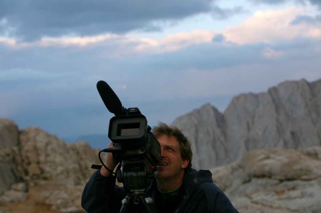
Filming during an expedition to summit Mt. Whitney for The New York Times. (Photo: Heidi Schumann for the New York Times.)
There’s a real joy in living somewhere so rich in natural beauty and ecological complexity, and in being able to pause, maybe pull out your phone, snap a photo, record a bird call, or look something up and start learning. If there’s one thread that has followed me throughout my life, even while living in many other places, it’s the sense that the world is filled with wonder, and that paying attention to it, learning from it, and staying curious about it is one of the things that makes life feel most meaningful.
California Curated grew out of that kind of crazy restlessness.
California feels like a living laboratory. The Sierra Nevada rise as a tilted slice of Earth’s crust, revealing granites that formed in fiery violence miles beneath the surface. The San Gabriels are growing a tiny, tiny bit each day as movement along the San Andreas system shears the landscape. Parts of today’s deserts were once seafloor, and the Central Valley held vast inland waters. The geology alone tells stories on a scale that is hard to fathom.
Monterey Canyon cuts into the continental shelf and descends more than 3,000 meters, forming one of the largest submarine canyons in North America. (MBARI)
And then there is the coast. California has roughly 840 miles of shoreline, and just offshore the seafloor drops away into one of the most extraordinary underwater landscapes on the planet. Monterey Canyon cuts into the continental shelf and descends more than 3,000 meters, forming one of the largest submarine canyons in North America. Because it begins so close to land, it has become a natural laboratory for ocean science. Institutions like Monterey Bay Aquarium Research Institute and Scripps Institution of Oceanography have spent decades studying the life and physics of these waters, leading to a much better understanding of how climate change is affecting the seas.
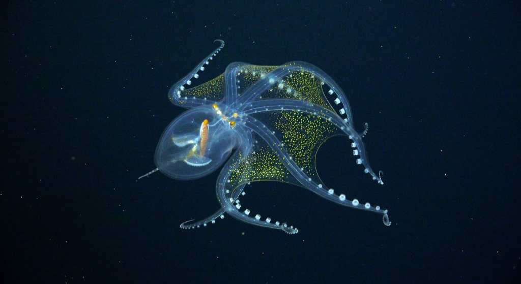
I’ve had the privilege of joining several major ocean expeditions around the world, including a submersible dive to more than 2,000 feet, as well as watching robotic vehicles descend into the twilight zone. On an expedition near Kiribati, I was one of the first people ever to witness a glass octopus floating like an alien in space. Experiences like these make it clear just how much of the deep ocean remains unknown. Few places, too, is that more true than off our own coast.
Glass octopus in the Phoenix Islands (Photo: Schmidt Ocean)
In the high Eastern Sierra, there is a supervolcano, a caldera, that once unleashed massive eruptions, blanketing much of the West in ash and reshaping the landscape we see today. You can not only still see its remnants up there, but you can luxuriate in hot springs that are heated by the same lingering geothermal energy beneath the surface. What could be better than being out in a place like that, and also understanding a little more about what you’re experiencing while you’re there?
That tension between wonder and ignorance is what drives this project.
Long Valley Caldera in the Eastern Sierra. (Photo: Erik Olsen)
California is rich in scientific discovery. Our universities are world-class. Our scientists and researchers are awash in Nobel prizes. California scientists have long shaped global conversations about health, biology, chemistry, physics, and on and on. Yet much of this work remains abstract, locked behind the expensive paywalls of scientific journals or lost in headlines that never quite connect back to the landscapes around us.
California Curated exists to close that gap.
The goal is not just to provide answers, but to make you look around differently. To give you enough context that the next time you hike a ridge, paddle a bay, or walk along a beach, you see a little more than before. Where does all that sand come from anyway? To spark the kind of curiosity that leads you to ask your own questions and even to seek your own answers.
I really don’t cover politics. I spent a few years doing that at ABC News in New York and quickly realized it wasn’t for me. Much of what fills our information feeds today is meant to provoke fear, anger, or to deliver a quick burst of dopamine, but it’s so often transient, fleeting, disposable. That isn’t what California Curated is about. I research and write these stories with the hope that they remain just as interesting and meaningful ten years from now as they are today.
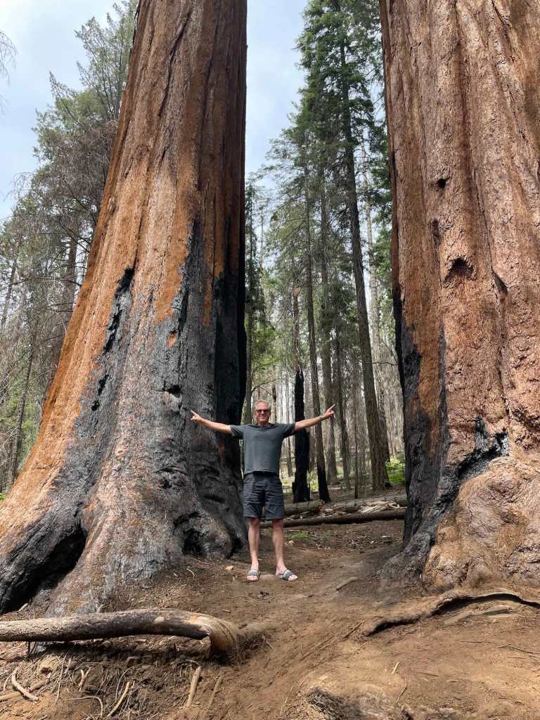
Burned sequoias. (Photo: Finley Olsen)
Every story begins with something small, a sighting, a conversation, an otherwise tangential paragraph in a bigger story, a nagging thought. From there, I get to dig in, read papers, call scientists, visit sites, and try to condense a complicated tumult of information into something more singular and compelling. It is a privilege to do that work. It’s fun.
That is what California Curated is about. Paying attention. Following the questions. And sharing what we find.
How tectonics, sediment, and water created one of the most productive landscapes on Earth.
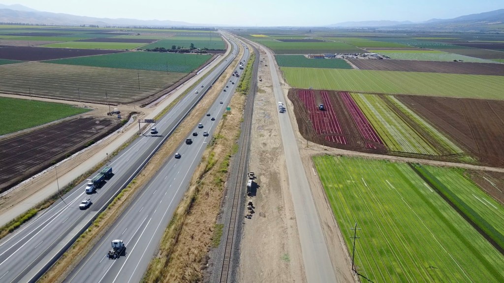
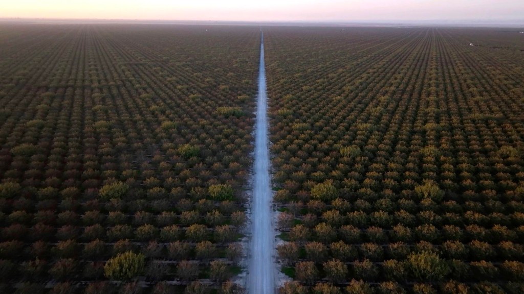
Aerial view of California’s Central Valley, where Interstate 5 slices through a vast patchwork of irrigated fields, some of the most productive farmland on Earth, shaped by deep alluvial soils and Sierra Nevada snowmelt. (Photo: Erik Olsen)
I love California’s bizarre, complicated geology. For many years, I had a wonderful raised-relief map of the state on my wall made by Hubbard Scientific (it hangs on my son’s bedroom wall today). On the map, color and molded plastic contours reveal the state’s diverse and often startling geological formations. I loved staring at it, touching it, imagining how those landscapes came to be over geologic time.
There is so much going on here geologically compared to almost any other state that geologists often describe California as one of the best natural laboratories on Earth, a place so rich and varied that entire careers have been built trying to understand how all its pieces fit together. As the U.S. Geological Survey (USGS) puts it, nearly every major force that shapes the Earth’s crust is visible here, from plate collision and volcanism to basin formation and mountain uplift. Some of my favorite writers, like John McPhee, have described California as a collage of geological fragments, assembled piece by piece over deep time, in a way that more closely resembles an entire continent than a single region.
But when we think about California’s geology, most of us probably imagine the Sierra Nevada’s towering granite peaks, the pent-up force of the San Andreas Fault, or the fact that Lassen Peak is still an active volcano. Those places grab our attention. Yet when it comes to a geological feature that has quietly shaped daily life in California more than almost any other, we should consider the Central Valley, arguably the state’s most important geological masterpiece.
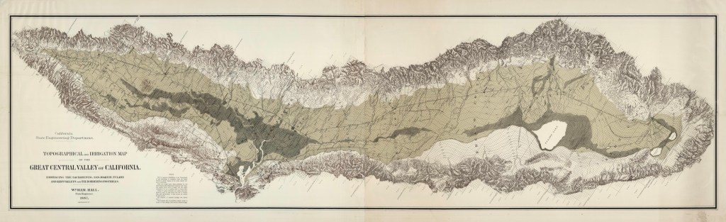
Topographical and irrigation map of the Great Central Valley of California: embracing the Sacramento, San Joaquin, Tulare and Kern Valleys and the bordering foothills (Source: NYPL Digital Collection)
Sure, the valley is flat as a tabletop, stretching out for mile after mile as you drive Interstate 5 or Highway 99 (one of my favorites), but once you consider how it formed and what lies beneath the surface, the Central Valley reveals itself as a truly remarkable place on the planet, another superlative in our state, which, of course, is already full of them.
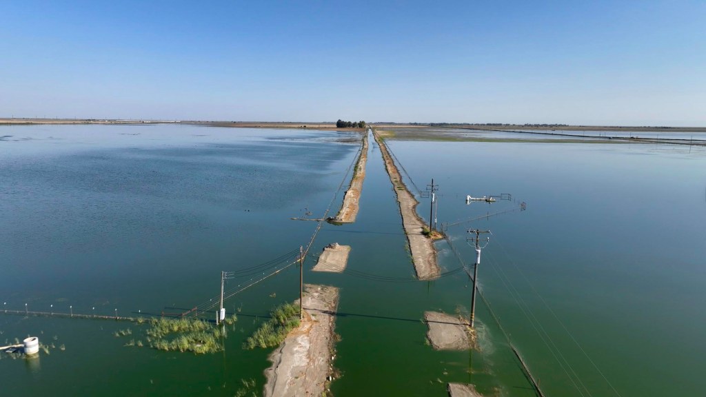
The Central Valley was formed when tectonic forces lowered a broad swath of California’s crust between the rising Sierra Nevada to the east and the Coast Ranges to the west, creating a long, subsiding basin that slowly filled with sediment eroded from those mountains over millions of years. For thousands of years, the southern end of the valley was dominated by Lake Tulare, a mega-freshwater lake that was once the largest freshwater lake west of the Mississippi. You might remember that just a few years ago, Lake Tulare briefly reappeared after a series of powerful atmospheric river storms. I went up there and flew my drone because I was working on a story about the construction of California’s long-troubled high-speed rail, which had halted construction because of the new old lake.
Lake Tulare reemerges in the southern San Joaquin Valley after powerful winter storms, flooding roads and farmland and briefly restoring the historic inland lake that once dominated this basin. (Photo: Erik Olsen)
On the other side in the west, the Coast Ranges rise up, hemming in the valley and basically holding it in place, forming something like a gigantic, hundreds-of-miles-long bathtub. One popular Instagrammer commented that it looks as if someone used a huge ice cream scoop to dig out the valley. As the surrounding mountains continued to rise, rain, snowmelt, and wind carried untold tons of silt and sediment downslope, steadily depositing them into this enormous basin over millions of years.
This process created what geologists call the Great Valley Sequence, a staggering accumulation of sedimentary material that, in some western portions of the basin, reaches a depth of 20,000 meters, or approximately 66,000 feet. Ten MILES.
Celebrate California’s wild side with our beautifully illustrated wildlife mugs, featuring the state’s most iconic birds and animals. Visit our store and bring a little piece of California nature to your morning coffee.
This long, slow process produced what geologists call the Great Valley Sequence, an immense stack of sedimentary rock built up over tens of millions of years as the basin steadily subsided and filled. In some western portions of the valley, that accumulated package reaches a depth of 20,000 meters in thickness, about 66,000 feet, or close to ten miles of layered geological history lying beneath the surface. That’s kind of mind-blowing.
Endless rows of pistachio orchards stretch across the Central Valley at dusk, a geometric testament to the deep soils and engineered water systems that have turned this ancient basin into one of the world’s great agricultural landscapes. (Photo: Erik Olsen)
It’s not just “dirt”; it’s a ridiculously deep, nutrient-rich record of California’s geologic history. There are the remains of trillions of diatoms, or microscopic plankton, whose organic remains were crushed into oil shales that are home to significant petroleum deposits. During the late Pleistocene and into the Holocene, the southern end of the valley was dominated by Lake Tulare, mentioned above, a vast freshwater lake that in wet periods spread across 600 to 800 square miles, making it the largest freshwater lake west of the Mississippi. As the water evaporated and drained, the valley floor became exceptionally flat, similar to what we see today.
Most valleys are narrow corridors carved by a single river, but the Central Valley is a vast, enclosed catchment shaped by many rivers, trapping minerals and sediments from surrounding mountains rather than letting them wash quickly out to sea. This mix created near-ideal conditions for agriculture. For the uninitiated, the Central Valley is typically divided into two major sections: the northern third, known as the Sacramento Valley, and the southern two-thirds, known as the San Joaquin Valley. That lower region can be further broken down into the San Joaquin Basin to the north and the Tulare Basin to the south.
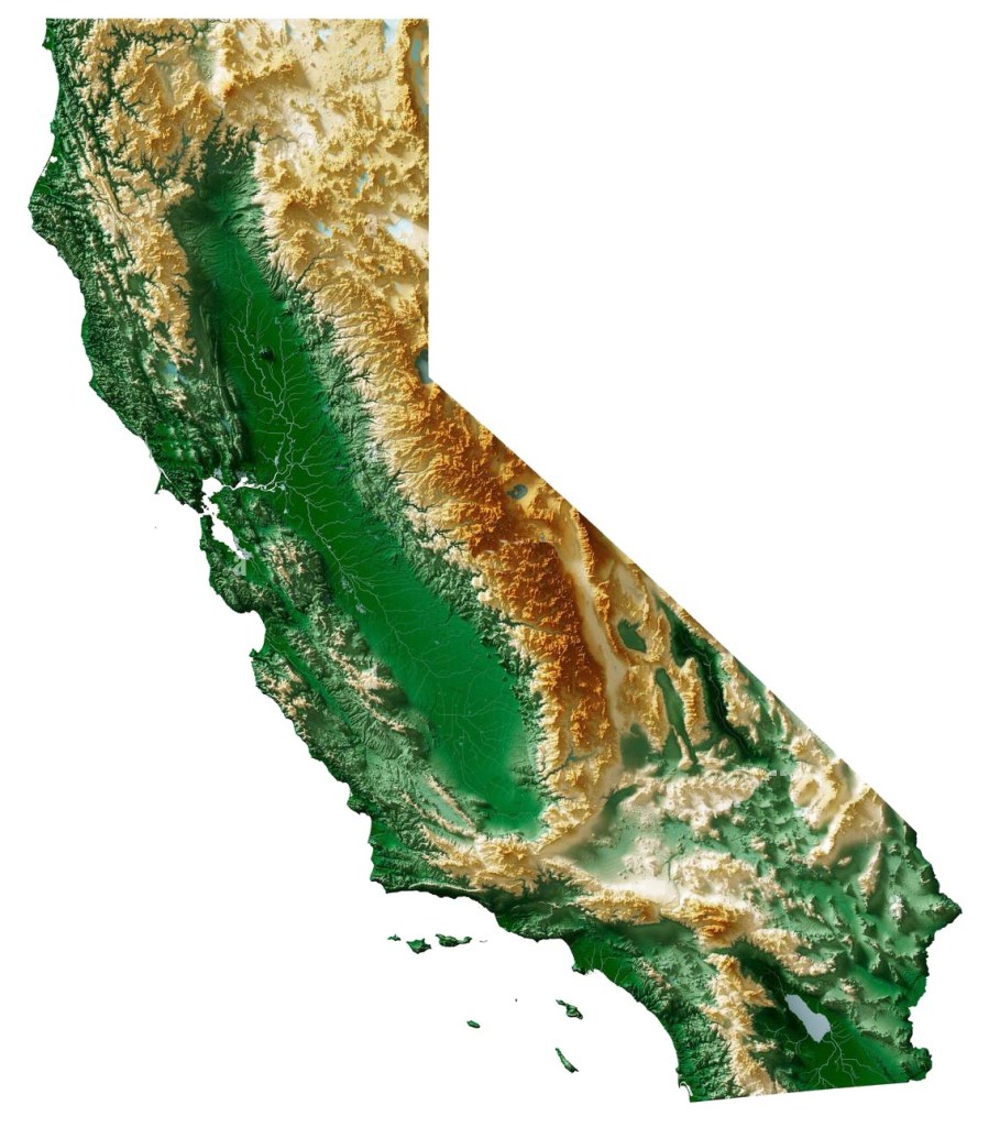
Relief map of California showing the Central Valley standing out as a wide, uninterrupted green swath between the rugged Sierra Nevada and the Coast Ranges, its flat, low-lying basin sharply contrasting with the surrounding mountains that frame and define it.
Today, because of all that fertility, the Central Valley is one of the world’s most productive agricultural regions, growing over 230 different crops. It produces roughly a quarter of the nation’s food by value, supplies about 40 percent of U.S. fruits, nuts, and vegetables, and dominates global markets for crops like almonds, pistachios, strawberries, tomatoes, and table grapes. Truly a global breadbasket.
Of course, none of this would have been possible without water. The real turning point in California’s story was learning how to capture it, move it, and store it. From mountain snowpack to canals and reservoirs, controlling water has been the quiet engine behind much of the state’s success. When human engineering intervened in the 20th century through the Central Valley Project and the State Water Project, it essentially redirected a geological process that was already in place, replacing seasonal floods and ancient lakes with a controlled system of dams and canals.
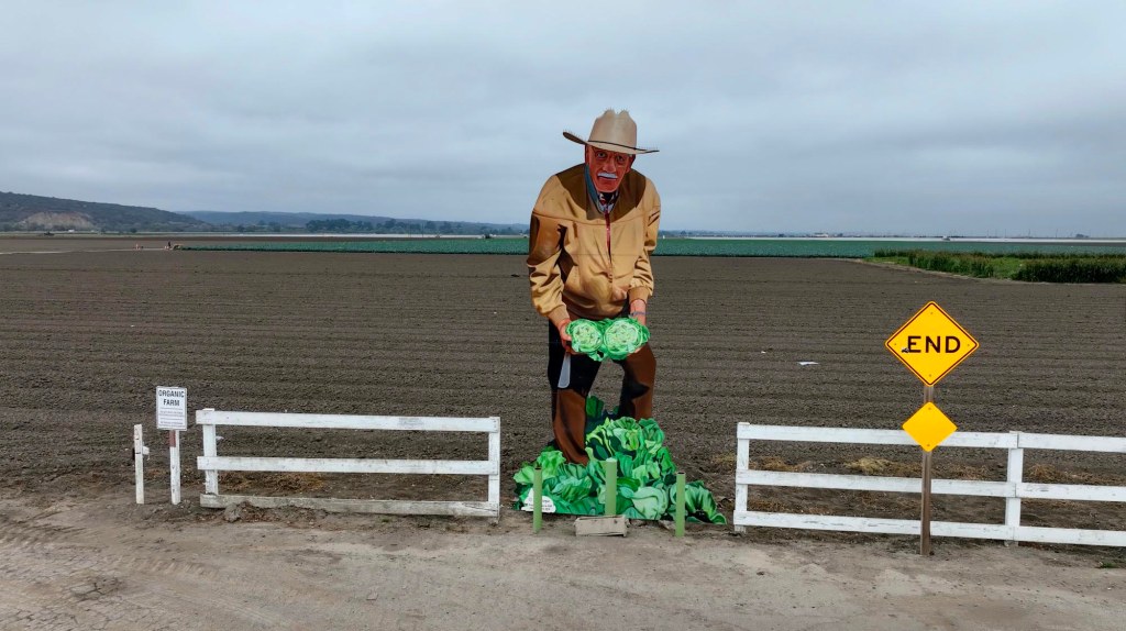
Roadside cutout farmer holding bright green heads of lettuce at the edge of a Central Valley field, a playful nod to the region’s identity as one of the most productive agricultural landscapes in the world. (Photo: Erik Olsen)
Alas, this productivity is not without geological limits, and we’ve done a pretty good job over-exploiting the valley’s resources, particularly groundwater, to achieve these things. The same porous sediments that store our life-giving groundwater are susceptible to compaction. In parts of the San Joaquin Valley, excessive pumping has caused the land to subside, sinking by as much as 28 feet in some locations, causing the soil to crack and the landscape to physically lower as the water is withdrawn. How we deal with that is a whole other story. Recent storms have helped California’s water supply tremendously, but the state seems destined to remain in a permanently precarious state of drought.
But when you talk geology, you talk deep time. You talk about eons and erosion, mountain ranges that rise and are slowly worn down, sometimes leaving behind something as breathtaking as the granite domes of Yosemite.Against that scale, the Central Valley can seem almost plain, but as I hope I’ve made the case here, when you look a little closer at even the most mundane things, you realize there is magnificence there, and few places on this planet are as magnificent as the state of California.
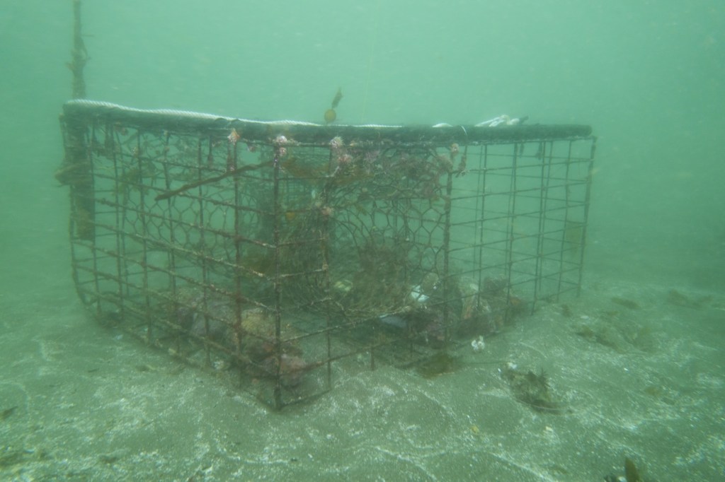
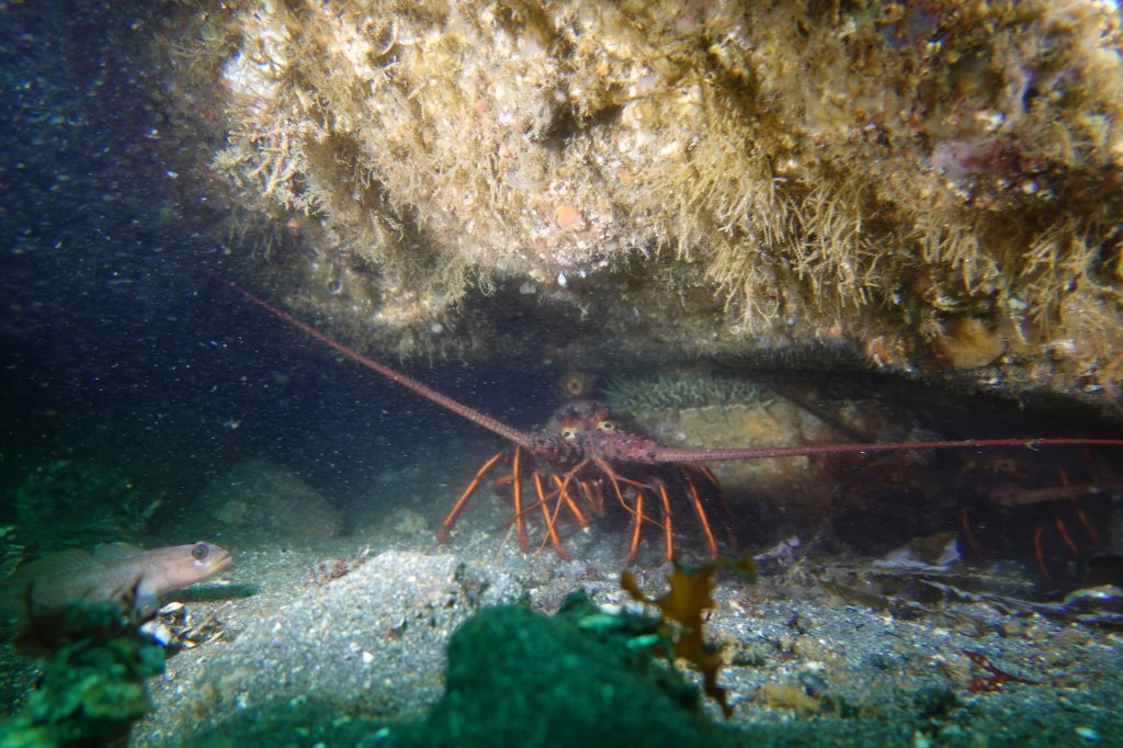
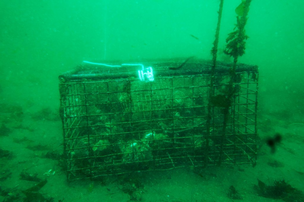
Ghost lobster trap off Santa Cruz Island in California’s Channel Islands (Photo: Erik Olsen)
Lobster is delicious. Let’s just get that out of the way. Yes, I’m sure there are some who either don’t enjoy the taste of this prolific crustacean, or who are allergic, but for my part, lobster (with a small vial of melted butter) is ambrosia from the sea.
But beyond its place on the plate, the California spiny lobster plays a vital ecological role: hunting sea urchins, hiding in rocky reefs, and helping to keep kelp forests in balance. Its value extends far beyond what it fetches at market. But beneath the surface, particularly around the Channel Islands lurks a growing problem that doesn’t just threaten lobsters. It threatens the entire marine ecosystem: ghost traps.
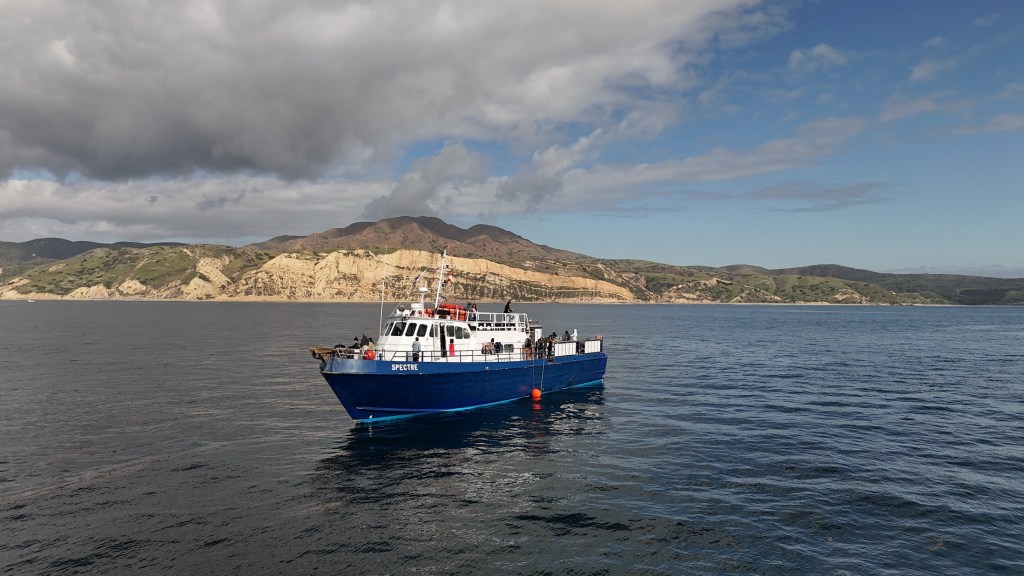
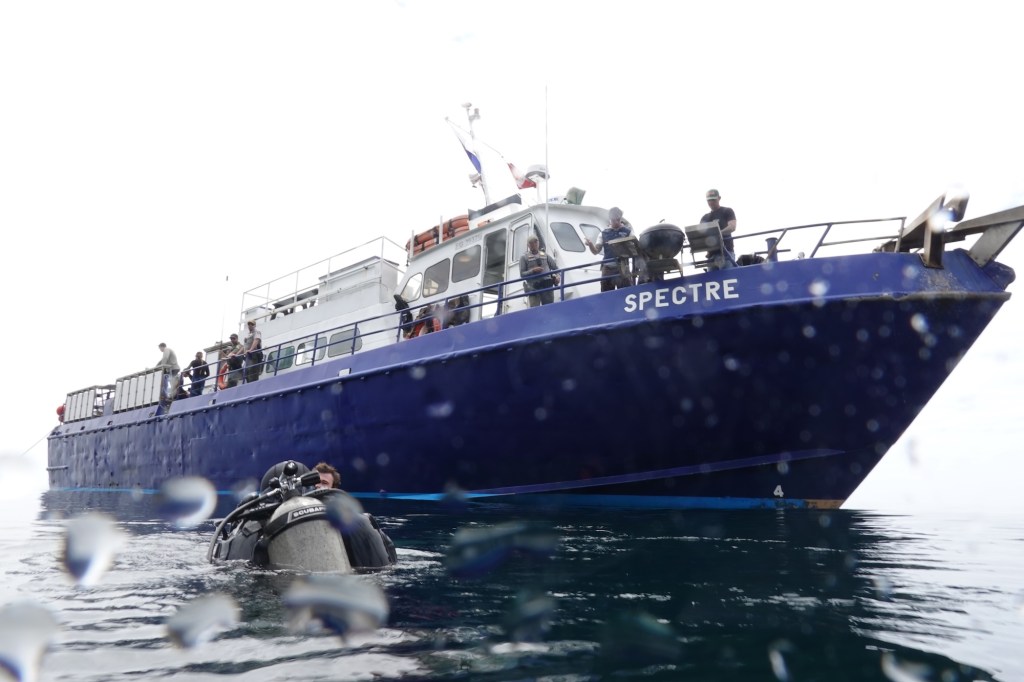
Dive ship Spectre off of Anacapa Island in California’s Channel Islands (Photo: Erik Olsen)
In Southern California, lobster fishing is both a cultural tradition and a thriving industry, worth an estimated $44 million annually to California’s economy from commercial landings as well as recreational fishing, tourism, and seafood markets.
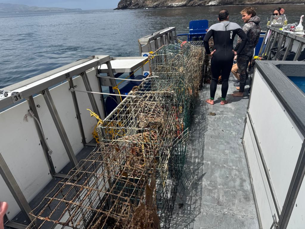
In late April, I traveled to the Channel Islands with my colleague Tod Mesirow to see the problem of ghost lobster traps firsthand. We were aboard the Spectre dive ship and pulled out of Ventura Harbor on an overcast morning, the sky a uniform gray that blurred the line between sea and cloud. The swell was gentle, but the air carried a sense of anticipati on. We were invited by the Benioff Ocean Science Laboratory, which is conducting research and outreach in the area. Our visit took us to Anacapa and Santa Cruz Islands, where I would be diving to observe the traps littering the sea floor. Tod, meanwhile, remained topside, capturing footage and speaking with marine scientists. Even before entering the water, we could see the toll: frayed lines tangled in kelp, buoys adrift, and entire areas where dive teams had marked clusters of lost gear.
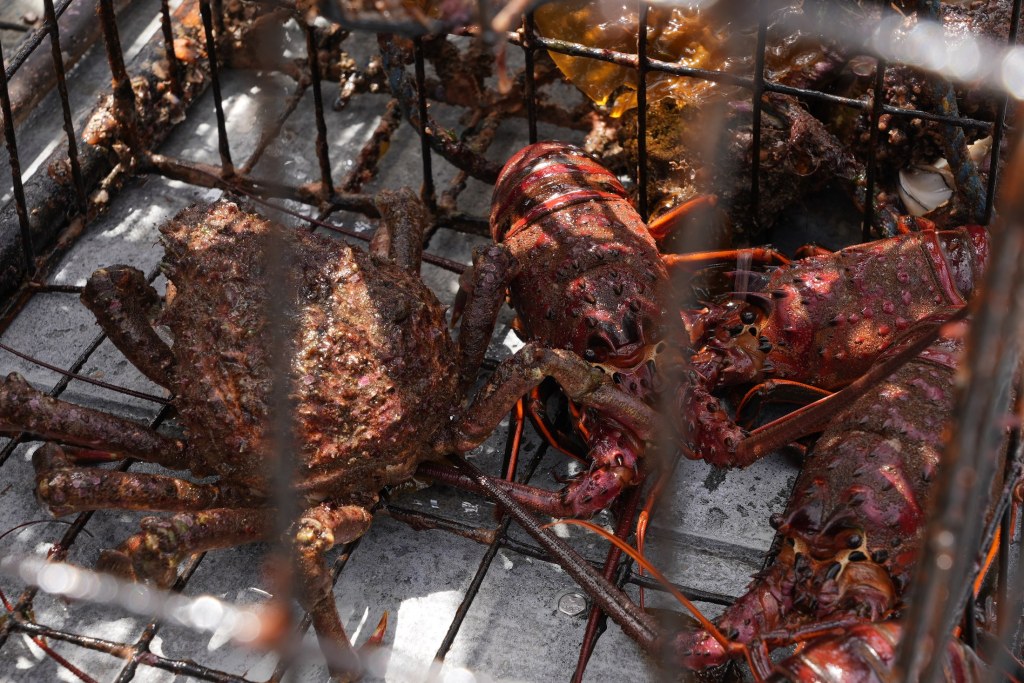
California spiny lobsters alive when the ghost trap was recovered (Photo: Erik Olsen)
Ghost traps are lobster pots that have been lost or abandoned at sea. Made of durable metal mesh and often outfitted with bait containers and strong ropes, these traps are built to last. And they do. For years. Sometimes decades. The problem is, even when their human operators are long gone, these traps keep fishing.
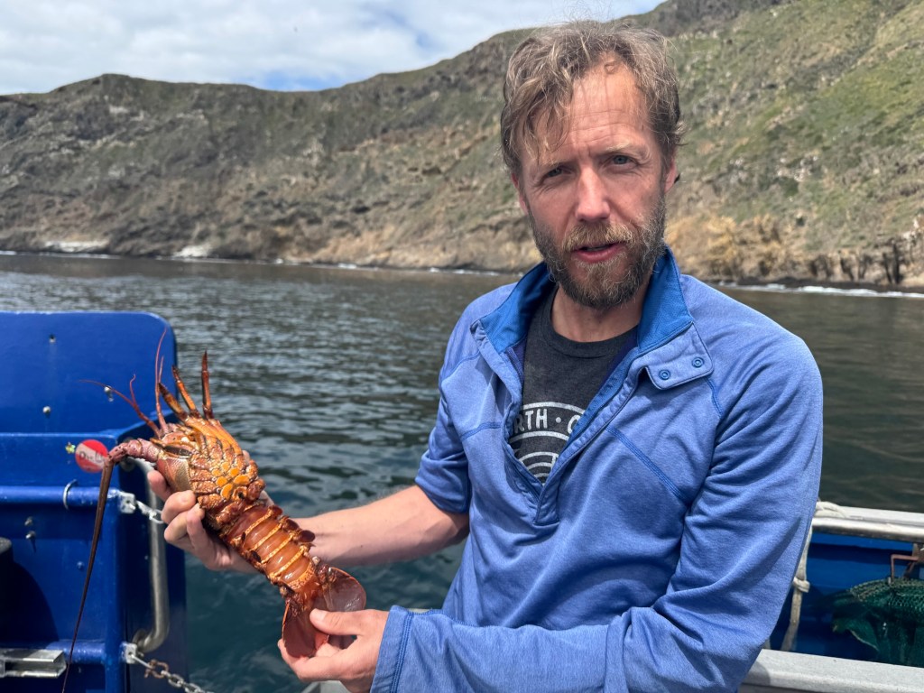
“It’s not uncommon to find multiple animals dead inside a single trap,” said Douglas McCauley, a marine science professor at UC Santa Barbara and director of the Benioff Ocean Science Laboratory who was onboard with us and leading the project. “It’s heartbreaking. These traps are still doing exactly what they were built to do, just without anyone coming back to check them.”
Douglas McCauley, director of the Benioff Ocean Science Laboratory at the University of California Santa Barbara holding a lobster caught in a ghost trap off the coast of the Channel Islands (Photo: Erik Olsen)
Around the Channel Islands National Marine Sanctuary, where fishing pressure is high and waters can be rough, thousands of traps are lost every season. Currents, storms, or boat propellers can sever buoys from their lines, leaving the traps invisible and unrecoverable. Yet they keep doing what they were designed to do: lure lobsters and other sea creatures inside, where they die and become bait for the next unfortunate animal. It’s a vicious cycle known as “ghost fishing.”
“They call them ghost traps because, like a ghost sailing ship, they keep doing their thing. They keep fishing.” said McCauley.
Statewide, the numbers are staggering. Approximately 6,500 traps are reported lost off the California coast each fishing season, according to The California Department of Fish and Wildlife. The folks at the Benioff Ocean Science Laboratory said as many as 6,000 may lie off the coast of the Channel Islands alone. Ocean Divers removing marine debris have found traps stacked three and four high in underwater ravines—rusting, tangled, but still deadly. These ghost traps don’t just catch lobsters; they also trap protected species like sheephead, cabezon, octopuses, and even the occasional sea turtle or diving seabird.
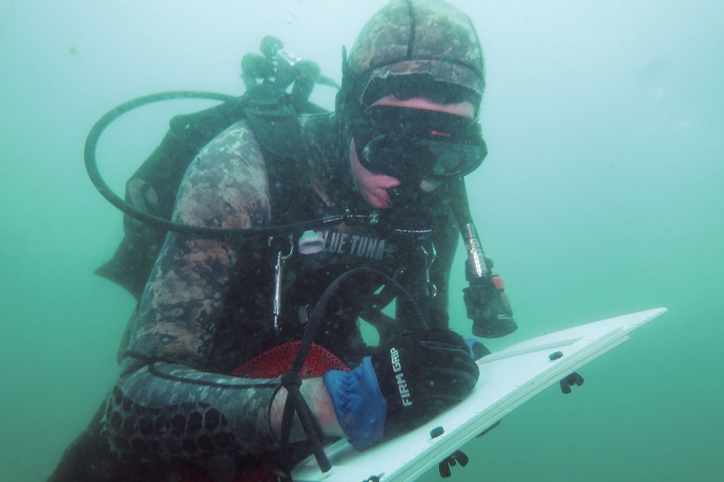
Diver and Project Scientist Chase Brewster of the Benioff Ocean Science Laboratory collecting data on ghost lobster traps near California’s Channel Islands (Photo: Erik Olsen)
Nowhere is this more evident than around the Channel Islands. These rugged islands are home to some of California’s richest kelp forests and underwater canyons. The islands and their surrounding waters are home to over 2,000 plant and animal species, with 145 of them being unique to the islands and found nowhere else on Earth. In fact, the Channel Islands are often referred to as North America’s Galapagos for the immense diversity of species here.
The islands are also the site of the state’s most productive spiny lobster fisheries. Every fall, hundreds of commercial and recreational fishers flood the area, setting thousands of traps in a race to catch California spiny lobsters (Panulirus interruptus). But rough swells and heavy gear mean traps go missing. Boats sometimes cut the lines of traps, making them near impossible to retrieve from the surface. And because this region is a patchwork of state waters, federal waters, and marine protected areas (MPAs), cleanup and regulation are anything but straightforward.
California Spiny Lobster off Anacapa Island (Photo: Erik Olsen)
The traps are often difficult to locate, partly because of their remote placement and the notoriously rough waters around the Channel Islands. But the Benioff Ocean Science Laboratory has a powerful asset: side scan sonar. From the ship, they can scan and map the seafloor, where the ghost traps often appear as dark, rectangular shapes against the sand. Once spotted, the team uses GPS to log their exact location.
“It’s creates a picture made of sound on the seafloor and you see these large lego blocks staring at you in bright yellow on the screen and those are your lobster traps,” sayd McCauley. “There’s nothing else except a ghost trap that looks like that.”
Plunging into the frigid waters off Santa Cruz Island was a jolt to the system. Visibility was limited, just 10 to 15 feet, but I followed two scientists from the Benioff Ocean Science Laboratory down to a depth of 45 feet. Their task: to attach a rope to the trap so it could be hauled up by the boat’s winch.
Dive ship Spectre off the coast of Santa Cruz Island in California’s Channel Islands (Photo: Erik Olsen)
The water was thick with suspended particles, the light dimming quickly as we dropped lower. My 7mm wetsuit was just barely enough to stave off the cold. On the seafloor, the ghost trap emerged, a large rectangular cage resting dark and ominous in the sand. And it was teeming with life. Fish darted around its edges, lobsters clambered along the frame, and inside, several animals moved about, trapped and slowly dying. It was easy to see how a single trap could wreak quiet havoc for years.
California law technically requires all lobster traps to include biodegradable “escape panels” with zinc hinges that degrade over time, eventually allowing trapped animals to escape. But enforcement is tricky, and the panels don’t always work as intended. In practice, many traps, especially older or illegally modified ones, keep fishing long after they should have stopped. That’s what we were out here to find.
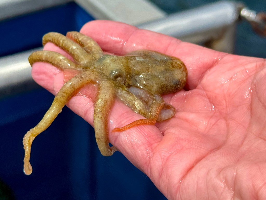
A baby octopus caught in a ghost trap in the waters off California’s Channel Islands (Photo: Erik Olsen)
Complicating matters is the fact that once a trap goes missing, there’s no easy way to retrieve it. Fishers are not legally allowed to touch traps that aren’t theirs, even if they’re obviously abandoned. And while a few small nonprofits and volunteer dive teams conduct periodic ghost gear removal missions, they can’t keep pace with the scale of the problem.
“At this fishery, we can’t get them all,” says McCauley. “But by going through and getting some species out and getting them back in the water, we’re making a difference. But in the process, we’re coming up with new ideas, new technologies, new research methods, which we think could play a role in and actually stopping this problem in the first instance.”
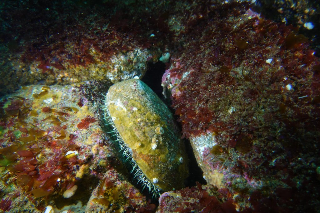
Once abundant along California’s coast, this large abalone spotted off Santa Cruz Island is a rare sight today—a quiet reminder of how overfishing, disease, and environmental change have decimated their populations. (Photo: Erik Olsen)
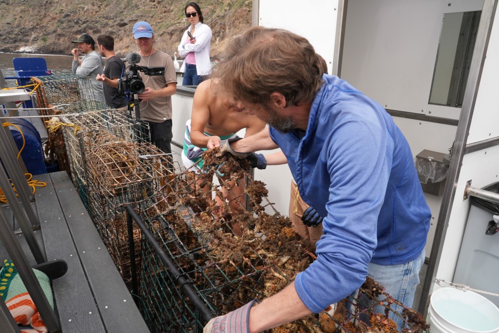
Back topside, the recovery team aboard the Spectre used a powerful hydraulic winch to haul the trap onto the deck. After climbing out of the cold water, still shivering, I joined the others to get a closer look. The trap was heavy and foul-smelling, but what stood out most was what was inside: lobsters, maybe ten or more. Some had perished, but many were alive and thrashed their tails when lifted by the scientists. Females could be identified by their broader, flatter tail fins—adapted to hold eggs. The team carefully measured each one before tossing them back into the sea, the lobsters flipping backward through the air and disappearing into the depths.
There were other animals, too. Large, rounded crabs known as Sheep crabs, common to these waters, scuttled at the bottom of the trap. Sea snails were clustered along the mesh, and in one cage, there were dozens of them, clinging and crawling with slow purpose. Even baby octopuses made appearances, slithering out onto the deck like confused aliens. I picked one up gently, marveling at its strange, intelligent eyes and soft, shifting forms, before tossing it back into the sea in hopes it would have another chance at life.
Ghost lobster trap lies on the seafloor off of Santa Cruz Island in California’s Channel Islands (Photo: Erik Olsen)
By then, the day had brightened and the sun had come out, easing the chill that lingered after the dive. The traps would be taken back to Ventura, where they’d likely be documented and disposed of. But this day wasn’t just about saving individual animals or pulling traps off the seafloor—it was about data. The Benioff team wants to understand just how big of a problem ghost traps really are. It’s not just about the number of traps lost each season, but the broader ecological toll: how many animals get caught, how many die, and how these traps alter the underwater food web. Every recovered trap adds a piece to the puzzle. This trip was about science as much as rescue.
State agencies, including the California Department of Fish and Wildlife (CDFW), have started pilot programs aimed at tackling ghost gear. In 2023, CDFW launched a limited recovery permit program that allows fishers to collect derelict traps at the end of the season, provided they notify the state. But participation is voluntary and poorly funded.
Elsewhere, states like Maine and Florida have created large-scale, state-funded programs to identify and remove ghost traps, often employing fishers in the off-season. California, despite having the nation’s fourth-largest lobster fishery, has yet to make a similar investment.
Ghost lobster traps recovered from the seafloor off the coast of California’s Channel Islands (Photo: Erik Olsen)
Some solutions are already within reach. Mandating GPS-equipped buoys for commercial traps could help track and retrieve gear before it’s lost. More robust escape hatch designs, made from materials that dissolve in weeks rather than months, would shorten the lifespan of a lost trap. And expanding retrieval programs with funding from fishing license fees or federal grants could make a big dent in ghost gear accumulation.
But even more powerful than regulation may be public awareness. Ghost traps are out of sight, but their damage is far from invisible. Every trap left behind in the Channel Islands’ waters becomes another threat to biodiversity, another source of plastic and metal waste, and another reminder that marine stewardship doesn’t stop when the fishing season ends.
Key to the whole effort is data:
“Every one of the animals that we put back in the water today, we’ll be taking a measure,” says McCauley. “After a little bit of crunching in the lab, we’ll be able to say, oh, actually, you know, every single trap undercuts the fishery by x percent for every single year that we don’t solve the problem.”
Doug McCauley with a lobster trap retrieved from the seafloor off the coast of California’s Channel Islands (Photo: Erik Olsen)
As we headed back toward Ventura, Tod and I talked with Douglas McCauley and Project Scientist Neil Nathan from the Benioff Ocean Science Laboratory. The team had collected a total of 13 traps that day alone, and 34 over the several days they’d been out. There was a sense of satisfaction on board, quiet but real. Each trap removed was a small win for the ecosystem, a little less pressure on an already strained marine environment.
“I would call today an incredible success, ” said Neil Nathan. “Feeling great about the number of traps we collected.”
California has long been a leader in ocean conservation. If it wants to stay that way, it needs to take ghost fishing seriously, not just around the Channel Islands, but up and down the coast. After all, we owe it to the lobsters, yes, but also to the underwater forests, reef communities, and countless species whose lives are tangled in the nets we leave behind.
A neighborhood threatened by landslides at Portuguese Bend on Palos Verdes (Erik Olsen)
For decades, geologists and engineers have been aware that the Portuguese Bend region of Palos Verdes is prone to landslides. Early maps and aerial surveys from the 1930s show continuous movement from the upper hills towards the high cliffs and bluffs that reach the Pacific Ocean.
Over the years, with a few exceptions, the ground movement was relatively slow, averaging about a foot per year. However, after the intense rains of the past year or two, the land is now shifting much more rapidly—up to 9 to 12 inches per week—plunging neighborhoods and communities built on this unstable terrain into panic and disarray. This accelerated movement has caused irreparable damage to some homes and led California to declare a state of emergency.
Aerial survey from the 1930s showing landslide potential at Portuguese Bend in Palos Verdes (Ranch Palos Verdes city government)
People have been allowed to build homes at Portuguese Bend largely due to a combination of historical oversight, demand for coastal real estate, and limited understanding of the area’s geologic instability when development first began. In the 1950s and 1960s, when much of the residential development in the area took place, there was less awareness and fewer regulations regarding the risks of building on unstable ground. Additionally, the picturesque coastal views and desirable location made Portuguese Bend an attractive area for developers and homeowners. Despite known landslide risks, building permits were often issued because of insufficient geotechnical assessments, political and economic pressures, and a lack of stringent land-use policies at the time. Over the years, as the understanding of the area’s geologic hazards has grown, there have been more restrictions and efforts to mitigate risks, but many homes already exist on land prone to movement.
The situation is similar to building homes in fire-prone areas – well-known to Californians, of course – within the so-called Wildland-Urban Interface (WUI), where human development meets and mixes with natural landscapes, creating a high-risk zone for natural disasters.
Small landslide at Portuguese Bend in Palos Verdes (Erik Olsen)
Portuguese Bend is one of the most active landslide zones on the peninsula. Here, the earth moves continuously, almost imperceptibly at times, but the effects are undeniable. The land isn’t just sliding; it’s flowing—like a slow-moving river of rock and dirt—down a natural depression, a sort of bowl or gulch formed by the interplay of tectonic activity and erosion. This gradual yet relentless descent toward the sea is driven by a combination of factors: the underlying geology of ancient marine sediment layers, heavy rainfall, and the constant forces of gravity pulling on the steep slopes. As a result, roads buckle, homes crack, and entire sections of land shift over time.
The geological makeup of Palos Verdes is complex and varied. The most prominent rocks on the Palos Verdes Peninsula, and the most crucial in terms of slope stability, belong to the Miocene Monterey Formation, which we wrote about in a previous article. This formation, over 2,000 feet thick in some areas, has been divided into three distinct members based on their rock types: the Altamira Shale, the Valmonte Diatomite, and the Malaga Mudstone, arranged from oldest to youngest.
Portuguese Bend at Palos Verdes
The Altamira Shale primarily consists of thin-bedded sedimentary rocks formed from layers of clay, interspersed with numerous layers of tuff, or volcanic ash that has largely transformed into weak clays over time. Thick deposits of volcanic ash, laid down millions of years ago, have been compacted into a clay-like material known as bentonite. When bentonite comes into contact with water, it becomes extremely slippery, acting like a natural lubricant. This slippery nature has been a major factor in triggering landslides throughout the Rancho Palos Verdes area, where the land’s stability is continually undermined by these underlying geological conditions.
Another factor contributing to landslides is the region’s tectonic activity. Palos Verdes sits above several active faults, including the Palos Verdes Fault. The movement along these faults exerts stress on the rock formations, leading to fractures and cracks that weaken the slopes. These cracks often become pathways for water to seep into the ground, further destabilizing the already precarious terrain.
The road along the coast at Portuguese Point has been moving for decades, a slow but relentless reminder of the dynamic nature of California’s landscape. (Erik Olsen)
Water plays a crucial role in triggering landslides in this region. Heavy rains, especially those associated with El Niño events like the atmospheric rivers of the last few years, can lead to a rapid increase in groundwater levels. When water infiltrates the ground, it increases the pressure within the soil and rock, reducing the friction that holds everything together. In Palos Verdes, where irrigation, septic systems, and urban development are common, human activities can exacerbate this natural process by altering drainage patterns and increasing water saturation in vulnerable areas. This convergence of natural and human-made factors makes the slopes more prone to sliding, particularly during or after intense rainfall.
To combat this, construction teams have installed a series of dewatering wells and pumps to actively extract groundwater from deep within the hillside. By lowering the water table and reducing the amount of water that saturates the soil, these efforts help to decrease the pressure within the slope and mitigate the risk of further ground movement. This method of dewatering is a crucial element in stabilizing the land, as it helps prevent the soil from becoming too heavy and reduces the lubricating effect that water has on the bentonite clay layers.
Closed road at Portuguese Bend in Palos Verdes (Erik Olsen)
Coastal erosion is another critical factor. The rugged cliffs of Palos Verdes are constantly being eroded by the ocean’s waves, wind, and rain. Over time, wave action undercuts the base of the cliffs, removing the support for the upper layers and leaving them hanging precariously over the ocean. As the base erodes away, the upper cliffs become more susceptible to collapse. When combined with the weakened geology and increased groundwater levels, this coastal erosion sets the stage for dramatic landslides.
Portuguese Point cliffs are part of the constant coastal erosion process at Palos Verdes aerial photo (Erik Olsen)
Recent studies are shedding new light on why landslides in Palos Verdes continue to be a concern. Geologists are now using advanced technologies, such as ground-penetrating radar and satellite imagery, to better understand the underground conditions that contribute to landslides. A study from the University of California, Los Angeles, has explored how even minor shifts in groundwater levels, exacerbated by climate change and increasingly unpredictable weather patterns, can tip the balance and trigger significant slope failures. This research emphasizes that it’s not just the obvious heavy rainfall events that pose a threat; subtle changes in water content due to human irrigation, drought, or even slight variations in precipitation can also destabilize these slopes over time.
Moreover, new geological mapping and subsurface studies have provided a clearer picture of the fault lines and the fractured rock layers beneath Palos Verdes. These studies suggest that the interaction between multiple fault zones may be more significant than previously thought, potentially increasing the region’s susceptibility to movement. Understanding these interactions is crucial for predicting future landslides and developing mitigation strategies.
But in the end, nature will likely have the final say.
Portuguese Bend in Palos Verdes (Erik Olsen)
The picture that emerges from these studies is one of a region where natural geological processes and human activities are in a delicate balance. It’s an ongoing fight that really offers a precarious vision of the future for residents and others who use the area for recreation. The weak rock formations, intersecting fault lines, and relentless coastal erosion create an environment where the land is always moving and on the brink of collapse. Add to this the unpredictable impacts of climate change, which can bring more intense storms and alter precipitation patterns, and it becomes clear why Palos Verdes is so prone to landslides.
Efforts to mitigate the risk are ongoing. Local governments and geologists are working to develop more effective monitoring systems and better land-use planning guidelines to manage development in these sensitive areas. Understanding the complex geology and hydrology of Palos Verdes is critical to preventing future disasters and protecting the communities that call this beautiful but unstable coastline home.
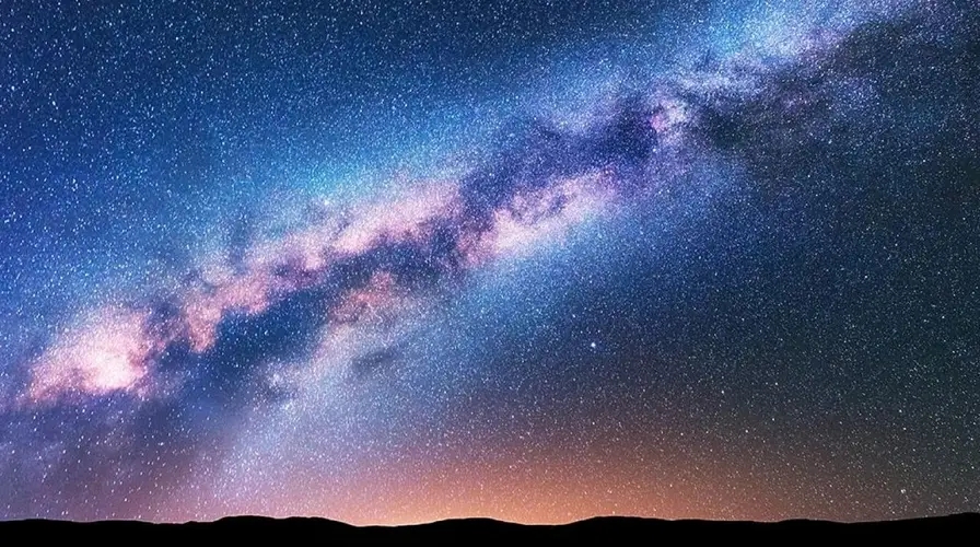
Despite its vast expanse (over 163,000 square miles) California offers surprisingly few places where one can truly gaze upon the night sky in all its glory. Urban light pollution has dimmed the stars across much of the state, making it a rare treat to see more than a handful of celestial points on a clear night. In California’s largest metropolitan areas, like Los Angeles and the Bay Area, the glow from light pollution is so intense that the Milky Way is almost entirely washed out, leaving just the brightest planets and stars visible.
Of course, this is not just a California problem. It’s a sobering reality that underscores a serious global issue: as of 2016, due to artificial lighting, about one-third of humanity could no longer see the Milky Way. Yikes. The problem has only worsened as many cities switch to LED lighting. While LEDs have revolutionized how we light our world and reduced the cost of illumination compared to incandescent bulbs, they have also diminished our ability to see the stars.
Light pollution in Los Angeles as seen from Angeles National Forest (Photo: Erik Olsen)
All that light at night also messes with our lives, interfering with circadian rhythms, leading to sleep disorders, increased stress, and potential long-term health issues such as obesity and cardiovascular disease, according to studies. Artificial light also disrupts ecosystems, affecting nocturnal wildlife by altering their natural behaviors and migration patterns, and can lead to decreased biodiversity. In fact, scientific evidence suggests that artificial light at night has negative and deadly effects on many creatures, including amphibians, reptiles, birds, mammals, insects, and plants.
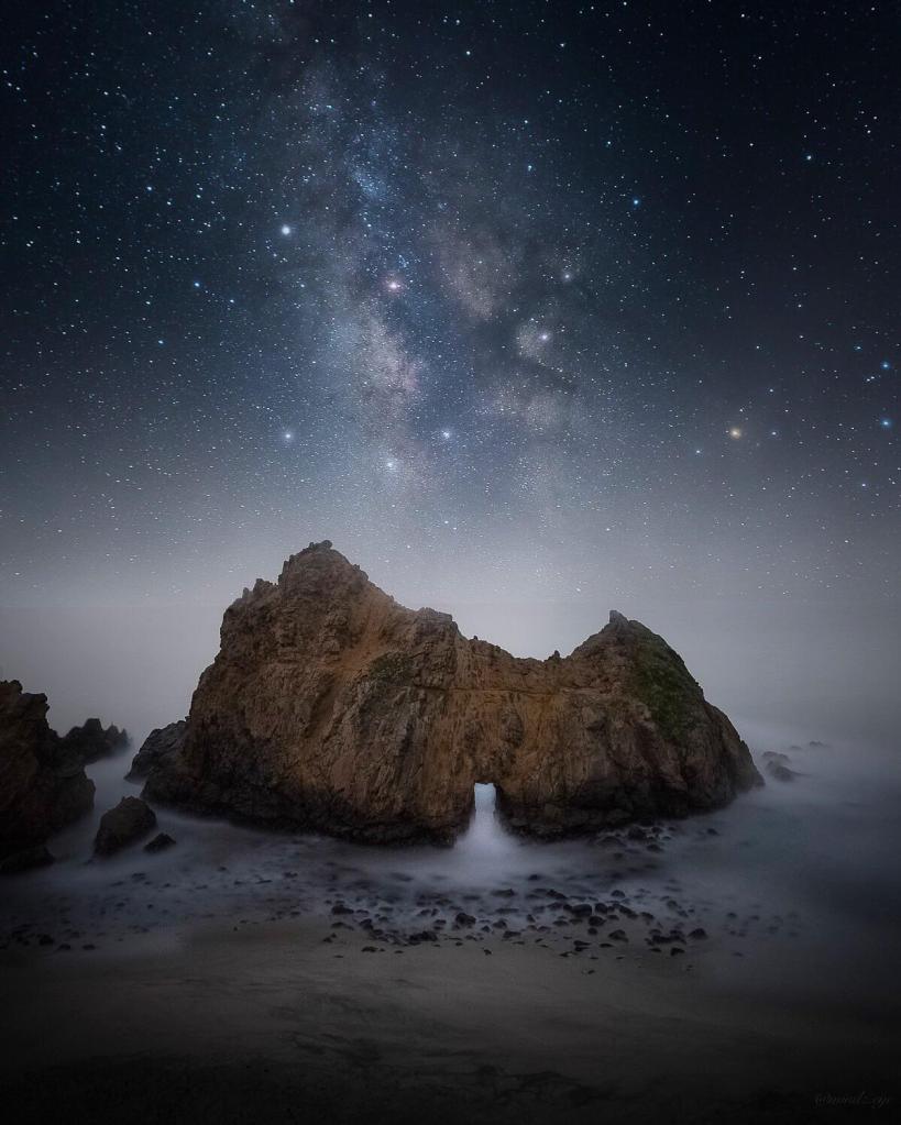
Dark parks in California offer a refuge from light pollution, providing a glimpse into the cosmos that most urban dwellers rarely experience. These parks are sanctuaries for stargazers, astronomers, and anyone longing to witness the majesty of the night sky. Spend a night camping in the Eastern Sierra, and you will know what I mean. There are few experiences in the natural world as profound as gazing into a blanket of millions and billions of stars and pondering the number of other worlds that might exist in the cosmos (it’s pretty much guaranteed there’s more than one, more than just us).
If only there was an organized effort to create and protect areas where darkness reigns. Enter the DarkSky International.
DarkSky International (previously the International Dark-Sky Association), founded in 1988, is dedicated to combating light pollution and preserving night skies through advocacy, education, and promotion of responsible outdoor lighting practices. They designate Dark Sky Places, including parks, reserves, and communities that meet rigorous lighting standards. As of now, there are just two designated Dark Sky Parks in California (see below) and over 130 across the United States. The IDA also works with policymakers to develop lighting regulations, supports scientific research on light pollution, and raises public awareness about the benefits of preserving dark skies for human health, wildlife, and the environment.
Death Valley National Park (Photo: NPS)
Dark skies are categorized using the Bortle Dark-Sky Scale, a system developed by amateur astronomer John E. Bortle to measure how much light pollution affects the visibility of stars and celestial objects. The scale ranges from Class 1, where the sky is pristine and free from artificial light, to Class 9, where the glow of urban lights makes it nearly impossible to see even the brightest stars. In a Bortle Class 1 sky, found in the most remote wilderness areas, you can see the Milky Way as a bright, detailed arc across the sky, along with countless stars and deep-sky objects. By contrast, in a Bortle Class 9 sky, such as in the heart of Los Angeles or New York City, only the moon, a few planets, and a handful of the brightest stars are visible. This scale offers a standardized way for scientists, conservationists, and amateur stargazers to assess the impact of artificial lighting and advocate for the preservation of natural darkness.
The night sky has always been a source of wonder and inspiration. For centuries, humans have looked up at the stars to navigate, tell time, and dream. Dark skies allow us to see celestial phenomena such as meteor showers, the Milky Way, and distant planets. They also foster a connection to the universe, reminding us of our place in a vast and mysterious cosmos. Beyond their aesthetic and inspirational value, dark skies have practical benefits too. They aid scientific research, support wildlife, and even improve human health by regulating our circadian rhythms, say researchers.
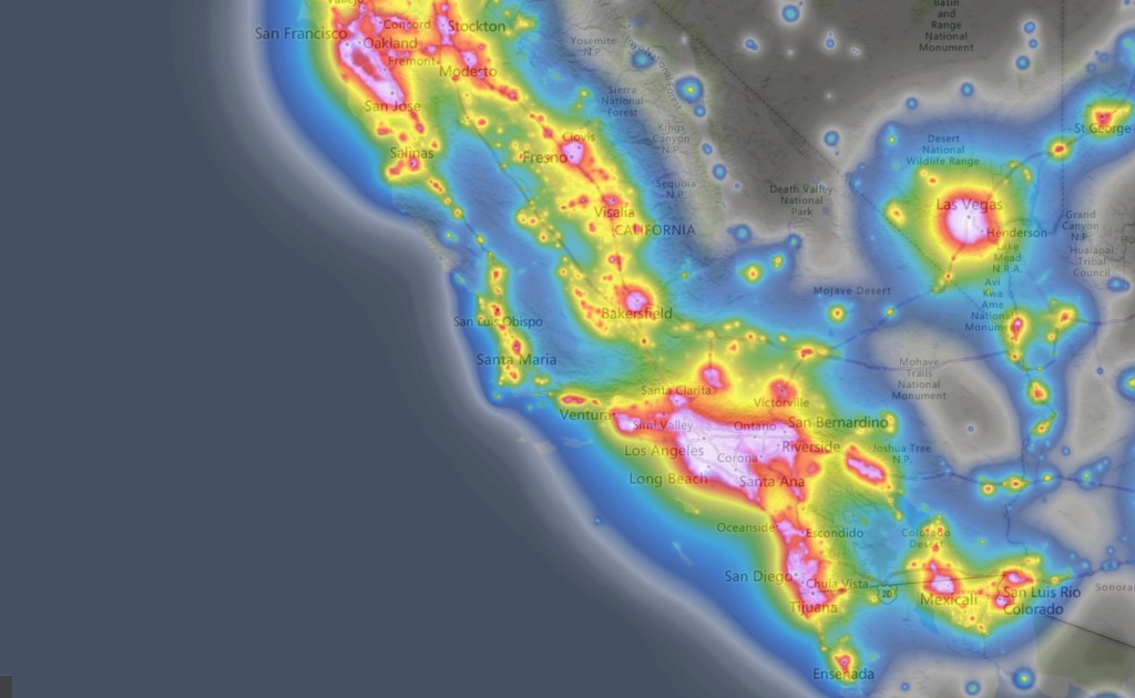
California light pollution map.
Advances in technology have revolutionized astrophotography, enabling photographers to capture the night sky in unprecedented detail. High-sensitivity digital cameras, sophisticated telescopes, and powerful image processing software allow for breathtakingly detailed images of celestial phenomena, from the intricate structures of distant galaxies to the ethereal glow of the Milky Way. These advancements have also made time-lapse photography more accessible, leading to a surge in mesmerizing time-lapse videos of the night sky. These videos, widely shared online (I’ve watched scores of them), showcase the dynamic beauty of the cosmos as stars and planets traverse the heavens. They offer viewers an immersive experience that reveals the universe’s grandeur and motion in a way static images cannot. This booming genre draws in audiences and encourages a deeper appreciation for the night sky, as well as the technology that makes stunning visual storytelling possible. Which raises an odd and unsettling question: what does it mean when we can have a better experience of the night sky by looking at a screen than by looking up at the sky itself?
For a glimpse into the latest in astrophotography, the Milky Way Photographer of the Year awards showcase some of the genre’s best work. Now in its seventh year, the competition by Capture the Atlas highlights 25 stunning images selected from over 5,000 entries, offering breathtaking views of our star-studded galaxy from around the world.
But all is not lost dear California friends. Outside the blazing urban megalopolises of Los Angeles/San Diego and San Francisco/San Jose, California boasts numerous places where visitors can escape the pervasive glow of artificial light. Here are a few of the best:
1. Death Valley National Park: Known for its extreme conditions and vast desert landscapes, Death Valley is one of the darkest places in the United States. The park is one of the two designated dark parks in California and the only one in the state classified as a Gold Tier Dark Sky Park. Its remote location and low humidity create ideal conditions for stargazing.The top ranger suggestions for star gazing locations in Death Valley National Park are: Mesquite Flat Sand Dunes, Harmony Borax Works, Badwater Basin and Ubehebe Crater.
2. Joshua Tree National Park: Famous for its unique rock formations and Joshua trees, this park is also a haven for astronomy enthusiasts. This is the second of California’s official dark parks. The park’s rugged terrain and minimal light pollution offer excellent visibility of the night sky. There are four designated stargazing areas in the park. They are the parking lots of Quail Springs, Hidden Valley, Cap Rock, and Ryan Mountain.
Night skies ablaze with stars and the Milky Way in Joshua Tree National Park (Unsplash)
4. Mount Shasta: If you’re able to go further north, Mount Shasta’s high elevation and clear skies make it a prime spot for observing the stars. The area’s natural beauty adds to the experience of a night under the stars. Everitt Vista Point and Bunny Flat at Mt. Shasta are prime spots for stargazing, along with Lake Siskiyou, Somes Bar, and Shafter Campground. Medicine Lake, near Lava Beds National Monument, also shines in this celestial line-up. Lake Siskiyou offers stunning reflections of the night sky, while Somes Bar and Shafter Campground are known for minimal light pollution and excellent visibility.
5. Pfeiffer Big Sur State Park: Stretching along the central coast, this park offers stunning views of the Pacific Ocean and a dark sky backdrop perfect for stargazing. The park’s coastal location can provide unique opportunities to see the stars reflected in the ocean below.
6. Mount Wilson Observatory: Perched atop a 1,740-meter peak in the San Gabriel Mountains, the Mount Wilson Observatory in Southern California, founded in 1904, boasts some of the largest telescopes available for public use. While primarily an educational venue, it offers an exceptional stargazing experience and a chance to delve into astronomy, appealing to both enthusiasts and experts. It’s just above Los Angeles, so, yeah, the skies aren’t that clear, but we have seen the Milky Way up there before. The observatory provides guided and self-guided tours year-round, making it an ideal destination for learning about the cosmos.
7. Oasis. Said to be the darkest place in California, this tiny little farming town tucked in between Death Valley National Park and the Nevada state line is the gateway to some of the best night gazing skies in the California desert. There’s a whole lot of wild area to the south, between Oasis and Ubehebe Crater in DVNP, that boasts skies as dark as any in the United States.
Photo: NASA
Dark parks in California, like Death Valley National Park and Anza-Borrego Desert State Park, offer incredible opportunities to reflect on your place in the cosmos. Beneath the inky blackness of a truly dark sky, the Milky Way stretches across the heavens in astonishing detail, and countless stars shimmer with a clarity that feels almost unreal. Just think about this for a moment: The Milky Way galaxy is home to an estimated 100 to 400 billion stars. And that’s just one galaxy! There are estimated to be between 100 billion and 2 trillion other galaxies out there. I mean, what?! It’s a scale so vast it’s almost impossible to comprehend.
And that’s what makes light pollution so sad and tragic. While we gain comfort and protection in our cities, the light we generate robs us of the chance to truly grasp our place in the universe. We are so small, and yet, as far as we know, we’re the only life out there. That’s a lot more thought-provoking than any Marvel movie (no offense to Marvel fans).
It’s true that the profound experience of stargazing fosters a deeper connection to the natural world and our place within it, reminding us of the wonder and mystery that lie beyond our planet. These are important things to remember. We owe it to ourselves to occasionally step away from the glow of our homes and cities and stand beneath a truly dark sky, where the universe stretches out above in a breathtaking display. In moments of reflection, we appreciate the invaluable gift of darkness, which not only preserves the nocturnal environment but also fuels our curiosity and sense of wonder—just as it has for our ancestors for thousands of years. By celebrating and protecting these dark parks, we ensure that future generations can continue to gaze up in awe, finding inspiration in the endless expanse of the cosmos.