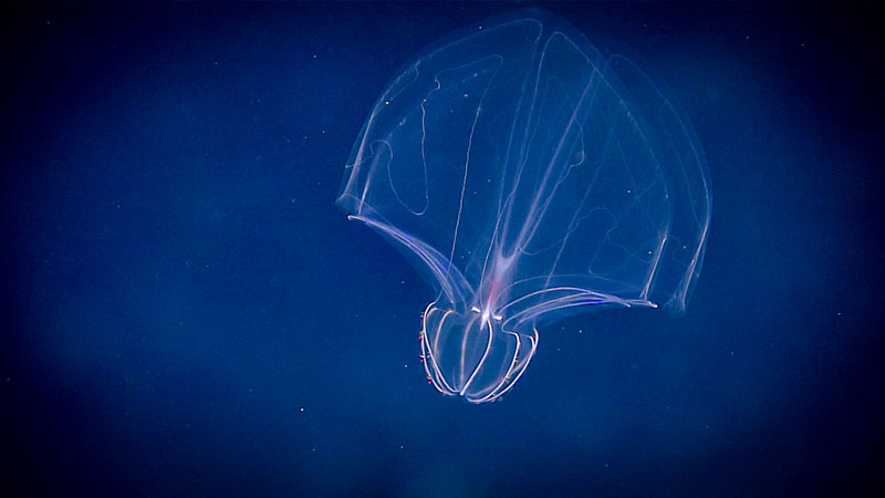
A lobate ctenophore in the ocean twilight zone. (Photo: NOAA)
If you’ve been reading this newsletter for a while, you already know I’m obsessed with submarines and undersea life. I believe we’re at the beginning of a new era of ocean discovery, driven by small personal submersibles, remotely operated vehicles (ROVS), and autonomous explorers (AUVs) that can roam the deep on their own. Add AI into the mix, and our ability to see, map, and understand the ocean is about to expand dramatically.
One phenomenon we are only beginning to fully understand also happens to be one of the most extraordinary animal events on Earth. It unfolds every single night, just a few miles offshore, in a region known as the ocean twilight zone about 650 to 3,300 feet below the ocean surface. Twice a day, billions of tons of marine organisms, from tiny crustaceans to massive schools of squid, traverse the water column in what researchers call the Diel Vertical Migration (DVM), the largest mass migration of animals on Earth. A heaving, planetary-scale pulse of biomass rising and falling through the dark.
It happens everywhere, in every ocean. But California is special for several reasons. California’s cold, southward-flowing current and seasonal upwelling flood coastal waters with nutrients that feed dense plankton blooms. These blooms provide food for thick layers of migrating animals. California has one of the most robust and productive ocean ecosystems on the planet. (Take a read of the piece I did about life on some of our oil rigs.) When you add Monterey Canyon into the mix, which funnels and concentrates life, this global phenomenon becomes more compressed and visible. In fact, with Monterey Bay Aquarium Research Institute (MBARI) based at Moss Landing near the head of the canyon, Monterey Bay has become one of the most intensively studied midwater ecosystems on the planet.
Monterey Bay Aquarium Research Institute (MBARI) in Moss Landing, perched at the edge of Monterey Canyon, one of the deepest submarine canyons in North America. (Photo: Erik Olsen)
This “tidal cycle of shifting biomass” is not driven by gravity, but by the rising and setting sun. Animals rise by the trillions during the evening to escape predation, then settle during the day, when light would otherwise make them visible to hungry predators.
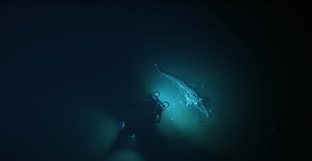
The discovery of this phenomenon reads like a Tom Clancy novel and took place just off our coast. During World War II, U.S. Navy sonar operators working off San Diego and the Southern California Bight began detecting what looked like a “false seafloor” hovering 300 to 500 meters down during the day, only to sink or vanish each night. The mystery lingered for years, until the late 1940s, when scientist Martin Johnson and others at Scripps Institution of Oceanography showed that the phantom bottom was not seafloor, but vast layers of living animals rising and falling with the sun. We now know this as the Deep Scattering Layer (DSL), so named because the gas-filled swim bladders of millions of small fish, primarily lanternfish which number into the quadrillions around the globe, reflect sonar pings like a solid wall.
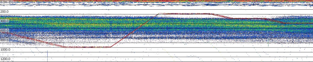
The deep-scattering layer (DSL) graphed as an echogram, or a plot of active acoustic data. Warmer colors indicate more backscatter, meaning that more (or stronger) echoes were received back from the organisms at that depth. The red line indicates the remotely operated vehicle (ROV) trajectory as it performs transects throughout the layer. (Source: NOAA)
So let’s talk about those amazing lanternfish, aka myctophids, a species that many peole have likely never heard of. These small fish may make up as much as 65 percent of all deep-sea fish biomass and are a major food source for whales, dolphins, salmon, and squid. They use tiny light organs called photophores to match faint surface light, a camouflage strategy known as counterillumination that helps hide them from predators below. These are just one of the many different species that inhabit the twilight zone as part of the DVM.
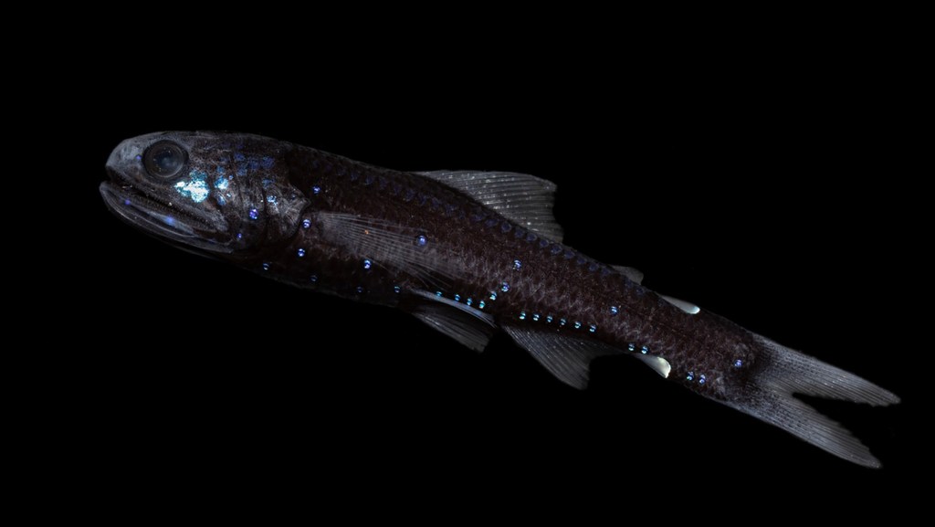
A lanternfish photographed in the ocean twilight zone, its body dotted with tiny light organs called photophores that help it blend into faint surface light as it migrates toward the surface at night. (Photo: NOAA)
Monterey Bay is arguably the world’s most important laboratory for DVM research, thanks to the Monterey Canyon, and several ground-breaking discoveries have come out of MBARI. For example, scientists at MBARI, including the legendary Bruce Robison, have used ROVs to document what they call “running the gauntlet,” when these migrators pass through layers of hungry, waiting predators. They encounter giant siphonophores with stinging tentacles, squids snag lanternfish, and giant larvaceans that build sprawling mucus “houses” that trap smaller animals. It’s like an epic battle scene out of Lord of the Rings, every single day.
This migration is also a key part of the ocean’s carbon cycle, which includes a scientific process known as the biological pump. When larger animals eat carbon-rich plankton at the surface, they eventually defecate all that carbon into the water, aka the “active transport” mechanism. Much of that carbon sinks to the bottom, sequestering it for decades or even centuries. In some regions, DVM accounts for one-third of the total carbon transport to the deep ocean. MBARI has a very interesting, long-term deep-ocean observatory called the Station M research site and observatory located nearly 12,000 feet below the surface off Santa Barbara. This site has been continuously monitored for more than three decades to track how organic matter produced near the surface eventually reaches the abyssal seafloor and feeds deep communities. I did a video about it for MBARI a few years ago.
Deployment of Mesobot, an autonomous midwater robot developed by Monterey Bay Aquarium Research Institute and Woods Hole Oceanographic Institution, for exploration of the ocean twilight zone above Monterey Canyon, California. (Photo: Erik Olsen)
Other cutting-edge technology is being brought to bear as well to help us better understand what life exists in the deep waters off California. A UC San Diego study shows that we can now use low-volume environmental DNA (eDNA) to detect the genetic signatures of huge numbers of different animals, even if we can’t see them. This free-floating DNA moves with ocean currents and can be sequenced to identify species ranging from copepods to dolphins, allowing researchers to track who is participating in the migration even when organisms are too small, fragile, or fast for traditional nets.
All of this plays out each day and night off our coast, a vast symphony of animal movement and deadly combat that, until recently, was not only poorly understood but largely invisible to science. And it’s all happening right off our shores
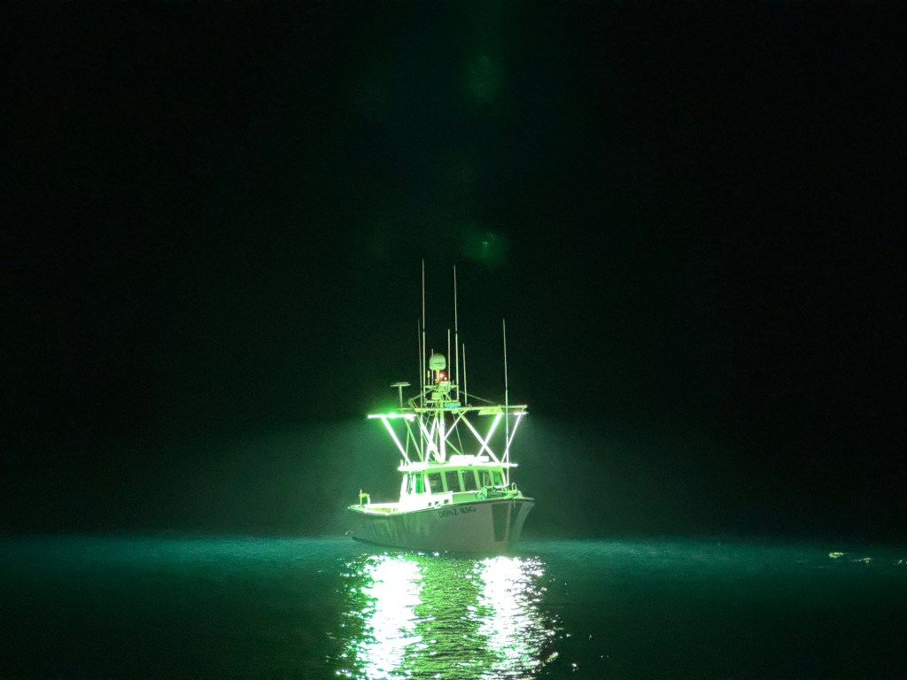
A few months ago, I took a fishing trip out to the western side of San Clemente Island. I woke at two in the morning to the rattle of the anchor chain dropping and stepped out onto the deck, expecting darkness all around us. Instead the night was alive with a strange glow. Dozens of squid boats floated offshore, their powerful lights illuminating the water with a bluish, Avatar-like brightness. The lights draw squid toward the surface before the crews scoop them up in nets.
As I knew from earlier research, and from being a long-time California resident, squid are one of California’s top commercial fisheries, a multimillion-dollar industry built around what is known as market squid. They thrive in enormous numbers in the deep waters around the Channel Islands and up toward Santa Barbara, even though the average beachgoer rarely thinks about them. From the rail of the fishing boat I was I could see vast swarms just below the surface.
Squid boat off shore San Clemente Island (Photo: Erik Olsen)
When dawn broke, San Clemente Island emerged ahead of us, and I was struck by how stark and empty it looked. In both directions stretched the same raw, rugged coastline, with almost no sign of human presence (there were what appeared to be radio towers on the top of a peak, but no people).
It felt desolate and otherworldly. But the reality is more complicated.
The island is part of the Channel Islands, a chain that trends east to west rather than the usual north–south pattern of most California ranges. The Channel Islands are often called North America’s Galápagos because they support an extraordinary number of species found nowhere else, shaped by the deep isolation that defines island biogeography (we wrote about this earlier).
San Clemente Island (photo: U.S. Navy)
San Clemente is no exception. The island is abundant in wildlife, with its own collection of rare plants and animals. But what makes it stand apart from the other islands is the scale of the military activity just beyond the barren cliffs. The U.S. Navy conducts constant training here, including missile tests, amphibious landings, and live-fire exercises. The island is considered one of the most important training grounds for the United States military, operating around the clock even as endangered species cling to survival in the canyons and plateaus nearby.
San Clemente Island looks like a long volcanic ridge from offshore, but it has been one of the most important and least visible military landscapes in California for almost a century. It is the southernmost of the Channel Islands and has been owned entirely by the U.S. Navy since the late 1930s. Over time it became a central part of Naval Base Coronado, and today its main airfield supports helicopters, jets, drones, and special operations teams that rotate through the island throughout the year.
It all seemed really interesting. I desperately wanted to go ashore, but if I’d tried, I almost certainly would have been arrested.
Live fire training exercises with mortars on San Clemente Island Photo: (Spc. William Franco Espinosa / U.S. Army National Guard)
The island began shaping military history just before World War II. In 1939, naval engineers brought early versions of the Higgins boat to San Clemente Island to test how they handled surf, wind, and timing with naval gunfire. These flat-bottomed landing craft became essential to Allied victories in places like Normandy and Guadalcanal. The island’s rugged shoreline helped the US military refine the tactics behind the amphibious assaults that defined twentieth century warfare.
During the Cold War, San Clemente Island evolved into one of the Navy’s busiest live fire training sites. The waters around Pyramid Cove hosted decommissioned ships used as targets. Carrier air wings practiced bombing runs across the southern plateau. Marine units rehearsed ship-to-shore landings on isolated beaches, while submarines conducted simulated missions under restricted airspace. We did a short video you can watch here.
Few places on the West Coast allowed sea, air, and land forces to operate together with real weapons, and the island’s remoteness made it ideal for rehearsing missions that couldn’t take place near populated coastlines. Yet all of this is happening just about 60 miles offshore from Los Angeles. (It took us about five hours to get back).
Higgins Boat (Photo: US Navy)
Civilian access has always been extremely limited, which is why the island only reaches the news when something unusual happens. One widely reported event occurred in 2023, when a private pilot illegally landed a small plane on the island’s runway and then stole a Navy truck before being detained. He tried again in 2025. This kind of thing underscores how isolated and tightly controlled the installation is. For the most part, the only people who ever set foot on the island are service members using it as a sophisticated, real world training environment.
Oh, and scientists, too.
That’s because the island’s natural history has been studied intensively. Decades ago, ranching introduced goats, sheep, and invasive plants that stripped vegetation from entire hillsides. Feral cats and rats preyed greedily on ground nesting birds, and live fire exercises fragmented habitat. By the 1970s and 1980s, San Clemente Island held one of the highest concentrations of endangered species in California, but everything was under threat.
San Clemente Island looks otherworldly and barren from a fishing boat (Photo: Erik Olsen)
Enter the U.S. Fish and Wildlife Service, which worked with the military to balance military readiness with the legal requirements of the Endangered Species Act. And it’s been, by many measures, a pretty major success.
No species became more symbolic of the struggle to protect the island than the San Clemente loggerhead shrike, a lovely, black masked songbird that lives nowhere else on Earth. By the late 1990s its wild population had fallen to as few as fourteen individuals. The Navy funded a comprehensive recovery effort that included captive breeding, predator removal, and habitat reconstruction, all with the expertise help of the San Diego Zoo Wildlife Alliance. By restoring vegetation and extensive breeding, scientists released shrikes which eventually began to hunt, build territories, and raise their young. The species is now considered one of the most successful island bird recoveries in North America.
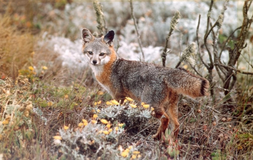
The San Clemente Island fox, once threatened by habitat loss and predation, has rebounded significantly thanks to intensive conservation efforts that stabilized its population and restored its native ecosystem. (Photo: USFWS)
And that wasn’t the only success. Once goats and sheep were removed, native shrubs and herbs began returning to the island. Endemic plants such as the San Clemente Island lotus and San Clemente Island paintbrush, responded quickly once the pressure from grazing disappeared. In 2023, after decades of habitat recovery, the Fish and Wildlife Service announced that five island species were healthy enough to be removed from the endangered species list, a pretty cool milestone that suggested a major ecological turnaround for San Clemente and the Channel Islands as a whole.
San Clemente Island lotus (Photo: USFWS)
Today, San Clemente Island remains one of the most unusual places in California. It is a live fire training range where carrier groups, SEAL teams, and Marines rehearse some of the most complex operations in the Navy. It is also a refuge where rare birds and plants have recovered after hovering near extinction. Conservation biologists and military planners now coordinate schedules, field surveys, and habitat protections to keep both missions intact. There’s an excellent documentary on this recovery effort made by SoCal PBS.
California has become a national leader in restoring damaged ecosystems. And while the state has lost much of its original wildness over the centuries, it also offers some of the most compelling examples of species and habitats recovered from the brink. San Clemente Island is more ecologically stable today than at any point in the past century, and it continues to serve as one of the Navy’s most valuable training grounds.
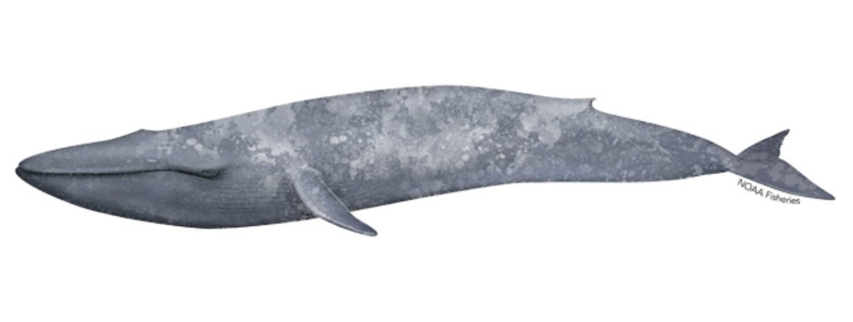
Blue whale off the California coast. (Photo: Erik Olsen)
Not So Big: How We Overstate the Length of the Blue Whale, Earth’s Largest Creature
One of the most extraordinary privileges of living in California, especially near the coast, is witnessing the annual arrival of blue whales. I’ve been at sea on several occasions when these giants surfaced nearby, and to see one in person, or even through my drone RC, is astonishing and unforgettable. I once had the rare and mind-blowing opportunity to swim with and film blue whales off the southern tip of Sri Lanka for a story I wrote and produced, an experience that will forever be seared into memory.
For decades, the blue whale has been celebrated as the largest creature ever to exist (Bigger than dinosaurs! True.), with many popular accounts claiming that these animals can reach lengths of 100 feet or more. Yet in all the videos, photographs, and encounters I’ve seen, not a single whale has come close to that. Still, article after article and documentary after documentary continues to repeat the claim that blue whales “reach 100 feet or more.” Nearly every whale-watching company in California repeats the claim, echoed endlessly across Instagram and TikTok.
But is it true? Most blue whales I’ve seen off the coast of California are half that size or maybe 2/3. It felt misleading to say so otherwise. And so I did a lot of digging: reading, reaching out to experts, poring over historical records, and the fact is that no single blue whale has ever been scientifically measured at 100 feet. Close, as you will soon read, but not 100 feet or more. Especially not off the coast of California.
This discrepancy not only distorts our understanding of these magnificent creatures, but also highlights the broader issue of how media can shape and sometimes mislead public perception of scientific facts.
Blue whale tail fluke in Sri Lanka. (Photo: Erik Olsen)
In other words: the perception that blue whales commonly reach lengths of 100 feet or more likely stems from a combination of historical anecdotes, estimation errors, and a tendency to highlight extreme examples.
All that said, the blue whale (Balaenoptera musculus) is a truly magnificent creature. Hunted nearly to extinction in the 17th to 19th centuries, the blue whale has staged a hopeful recovery in the last five decades, since commercial whaling was outlawed by the international community in 1966 (although some Soviet whale hunting continued into the early 1970s). And California, in particular, has been blessed with the annual appearance of the largest population of blue whales in the world, called the Eastern North Pacific population, consisting of some 2,000 animals. That population makes an annual migration from the warm waters of Baja California to Alaska and back every year. This is the group I’ve seen off Newport Beach.
These numbers are painfully, tragically small compared to what existed before commercial whaling began. Prior to that, it was estimated that there were some 400,000 blue whales on earth. 360,000 were killed in the Antarctic alone. (IMO: this stands as one of the most shameful acts in human history).
The International Union for Conservation of Nature estimates that there are probably between 5,000 to 15,000 blue whales worldwide today, divided among some five separate populations or groups, including the Eastern North Pacific population. Many now swim so close to shore that an entire whale-watching industry has flourished along the California coast, especially in the south, with many former fishing boats converted into whale-watching vessels..
But back to size, or, more specifically, length: there are two credible references in scientific papers of blue whales that are near 100 feet. The first is a measurement dating back to 1937. This was at an Antarctic whaling station where the animal was said to measure 98 feet. But even that figure is shrouded in some suspicion. First of all, 1937 was a long time ago, and while the size of a foot or meter has not changed, a lot of record-keeping during that time is suspect, as whales were not measured using standard zoological measurement techniques (see below). The 98-foot specimen was recorded by Lieut. Quentin R. Walsh of the US Coast Guard, who was acting as a whaling inspector of the factory ship Ulysses. Sadly, there is scant detail available about this measurement and it remains suspect in the scientific community.
The second is from a book and a 1973 paper by the late biologist Dale W. Rice, who references a single female in Antarctica whose “authenticated” measurement was also 98 feet. The measurement was conducted by the late Japanese biologist Masaharu Nishiwaki. Nishiwaki and Rice were friends, and while both are deceased, a record of their correspondence exists in a collection of Rice’s papers held by Sally Mizroch, co-trustee of the Dale W. Rice Research Library in Seattle. Reached by email, Dr. Mizroch said that Nishiwaki, who died in 1984, was a very well-respected scientist and that the figure he cited should be treated as reliable.
According to Mizroch, who has reviewed many of the Antarctic whaling records from the whaling era, whales were often measured in pieces after they were cut up, which greatly introduces the possibility for error. That is likely not the case with the 98-foot measurement, which took place in 1947 at a whaling station in Antarctica where Nishiwaki was stationed as a scientific observer.
Blue whale (NOAA)
Proper scientific measurements, the so-called “standard method”, are taken by using a straight line from the tip of the snout to the notch in the tail flukes. This technique was likely not used until well into the 20th century, said Mizroch. In fact, it wasn’t until the 1940s that the use of a metal tape measure became commonplace. According to Dan Bortolotti, author of Wild Blue: A Natural History of the World’s Largest Animal, many of the larger whales in the whaling records — especially those said to be over 100 feet — were probably measured incorrectly or even deliberately exaggerated because bonus money was paid to whalers based on the size of the animal caught.
So, according to the best records we have, the largest blue whale ever properly measured was 98 feet long. Granted, 98 feet is close to 100 feet, but it’s not 100 feet, and it’s certainly not over 100 feet, as so many otherwise reputable references state.
So, setting aside the fact that so many sources say the blue whale has reached 100 feet or more, and that there is no scientific evidence proving this, a key question to ask is how large can whales become?
Blue whale from the National Oceanic and Atmospheric Administration
Most baleen whales are so-called lunge feeders. They open their mouths wide and lunge at prey like krill or copepods, drawing in hundreds of pounds of food at a time. Lunge-feeding baleen whales, it turns out, are wonderfully efficient feeders. The larger they become, the larger their gulps are, and the more food they draw in. But they also migrate vast distances, and oftentimes have to dive deep to find prey, both of which consume a large amount of energy.
A 2019 scientific paper in Science described how a team of researchers used an ocean-going Fitbit-like tag to track whales’ foraging patterns, hoping to measure the animals’ energetic efficiency, or the total amount of energy gained from foraging, relative to the energy expended in finding and consuming prey. The team concluded that there are likely ecological limits to how large a whale can become and that maximum size in filter feeders “is likely constrained by prey availability across space and time.” That is especially the case in today’s era, when overfishing and illegal fishing, including krill harvesting in Antarctica, have reduced the amount of prey available even in regions that used to be very prolific.
Whale fall off the California Coast (Ocean Exploration Trust)
John Calambokidis, a Senior Research Biologist and co-founder of Cascadia Research, a non-profit research organization formed in 1979 based in Olympia, Washington, has studied blue whales up and down the West Coast for decades. He told California Curated that the persistent use of the 100-foot figure can be misleading, especially when the number is used as a reference to blue whales off the coast of California.
The sizes among different blue whale groups differ significantly depending on their location around the globe. Antarctic whales tend to be much bigger, largely due to the amount of available food in cold Southern waters. The blue whales we see off the coast of California, Oregon, Washington and Alaska, are part of a different group from those in Antarctica. They differ both morphologically and genetically, and they consume different types and quantities of food. North Pacific blue whales, our whales, tend to be smaller and likely have always been so. Calambokidis believes that the chances any blue whales off the West Coast of the US ever reaching anything close to 100 feet is “almost non-existent”.
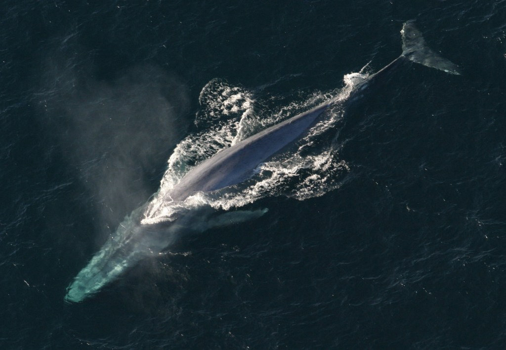
I emailed Regina Asmutis-Silvia, Executive Director North America of Whale and Dolphin Conservation, to ask about this discrepancy among so many seemingly authoritative outlets. She wrote: “While it appears biologically possible for blue whales to reach or exceed lengths of 100’, the current (and limited) photogrammetry data suggest that the larger blue whales which have been more recently sampled are under 80 feet.” Photogrammetry is the process of using several photos of an object — like a blue whale — to extract a three-dimensional measurement from two-dimensional data. It is widely used in biology, as well as engineering, architecture, and many other disciplines. Photogrammetry measurements are now often acquired by drones and have proven to be a more accurate means of measuring whale size at sea.
Antarctic whaling station.
Here’s a key point: In the early part of the 20th century and before, whales were measured by whalers for the purpose of whaling, not measured by scientists for the purpose of science. Again, none of this is to say that blue whales aren’t gargantuan animals. They are massive and magnificent, but if we are striving for precision, it is not accurate to declare, as so many articles and other media do, that blue whales reach lengths of 100 feet or more. Or to insinuate that this size is in any way common. This is not to say it’s impossible that whales grew to or above 100 feet, it’s that, according to the scientific records, none ever has.
A relevant point from Dr. Asmutis-Silvia about the early days of Antarctic whaling: “Given that whales are long-lived and we don’t know at what age each species reaches its maximum length, it is possible that we took some very big, very old whales before we started to measure what we were taking.”
In an email exchange with Jeremy Goldbogen, the scientist at Stanford who authored the study in Science above, he says that measurements with drones off California “have been as high as 26 meters” or 85 feet.
So, why does nearly every citation online and elsewhere regularly cite the 100-foot number? It probably has to do with our love of superlatives and round numbers. We have a deep visceral NEED to be able to say that such and such animal is the biggest or the heaviest or the smallest or whatever. And, when it comes down to it, 100 feet is a nice round number that rolls easily off the tongue or typing fingers.
All said, blue whales remain incredible and incredibly large animals, and deserve our appreciation and protection. Their impressive rebound over the last half-century is to be widely celebrated, but let’s not, in the spirit of scientific inquiry, overstate their magnificence. They are magnificent enough.
You can keep your Oscars, Emmys, Grammys, and Tonys. Take your Pulitzers, Bookers, and Peabodys, too. Even the Pritzker and the Fields Medal don’t quite measure up. For me, nothing competes with the Nobel Prize as a symbol that someone has truly changed the world.
I’m not a scientist, but my mind lives in that space. Science, more than anything else, runs the world and reshapes it. This newsletter was born out of my fascination with how things work and the quiet mechanics behind the visible world and my love for all that California has to offer in the way of innovation and natural beauty. I love standing in front of something familiar and asking: why? how? what exactly is going on here? And nothing satisfies that intense curiosity more than science.
That said, I’ve never loved the word science. It feels cold and sometimes intimidating, as if it applies to people in lab coats and not to everyone else. I kinda wish there were a better word for that spirit of discovery that lives in all of us. Maybe it’s wonder. Maybe curiosity. I dunno. “Science” turns people off sometimes, unfortunately.
Whatever you call it, the Nobel Prize represents the highest acknowledgment of that pursuit. It is the world’s way of saying: this mattered. This changed something. And there are few places (if any) on Earth that can rival California when it comes to the number of people who have earned that honor.
This year, 2025, was no different. Three of the Nobel Prizes announced this week carried California fingerprints, adding to a tradition that stretches back more than a century.
The Nobel Prize in Physiology or Medicine came first. It went to Mary Brunkow, Shimon Sakaguchi, and Fred Ramsdell, the last of whom studied at UCLA and UC San Diego. (In epic California fashion, Ramsdell, who studied at UCLA and UC San Diego, didn’t even learn he’d become a Nobel laureate until after returning from a trip deep into the Wyoming wilderness, where he’d been out of contact with the outside world. What’s more Californian than that?) Their research on regulatory T cells explained how the immune system knows when to attack and when to stand down. Ramsdell’s discovery of a key gene that controls these cells has transformed how scientists think about autoimmune disease and organ transplantation.
Next came the Nobel Prize in Physics, awarded to John Clarke of UC Berkeley, Michel H. Devoret of UC Santa Barbara and Yale, and John M. Martinis of UC Santa Barbara (big shout out to UCSB!). Their award honored pioneering work that revealed how the strange laws of quantum mechanics can be seen in circuits large enough to hold in your hand. Beginning in Clarke’s Berkeley lab in the 1980s, the trio built superconducting loops that behaved like subatomic particles, “tunneling” and flipping between quantum energy states. Those experiments helped create the foundation for today’s quantum computers.
The Chemistry Prize followed a day later, shared by Susumu Kitagawa, Richard Robson, and Omar M. Yaghi of UC Berkeley for discoveries in metal–organic frameworks, or MOFs. These are crystalline materials so porous that a single gram can hold an entire roomful of gas (mind blown). MOFs are now used to capture carbon dioxide, filter water, and even pull drinking water from desert air. Yaghi’s Berkeley lab coined the term “reticular chemistry” to describe this new molecular architecture. His work has become one of California’s most important contributions to the climate sciences.
California Institute of Technology (Photo: Erik Olsen)
Those three announcements in as many days lit up California’s scientific community, has garnered many headlines and carried on a tradition that has made the state one of the world’s most reliable engines of Nobel-level discovery.
The University of California system now counts 74 Nobel Prizes among its faculty and researchers. 23 in physics and 16 in chemistry. Berkeley leads the list, with 26 laureates, followed by UC San Diego, UCLA, UC Santa Barbara, and UC San Francisco. Even smaller campuses, such as UC Riverside, have ties to winners like Barry Barish, who shared the 2017 Nobel in Physics for detecting gravitational waves.
Linus Pauling with an inset of his Nobel Prize in 1955 (Wikipedia – public domain)
Caltech, which I have written about extensively and is quite close to my own home, counts 47 Nobel laureates (faculty, alumni, or postdocs). Its history is the stuff of legend. In 1923, Robert Millikan won for measuring the charge of the electron. In 1954, Linus Pauling received the Chemistry Prize for explaining the nature of the chemical bond. He later won the Peace Prize for his anti-nuclear activism, making him the only person to win two unshared Nobels.
Stanford University sits not far behind, with 36 Nobel winners in its history and about 20 currently active in its community. From the development of transistors and lasers to modern work in medicine and economics, Stanford’s laureates have changed the modern world in ways that is impossible to quantify, but profound in their impact.
These numbers tell a clear story: since the mid-twentieth century, about one in every four Nobel Prizes in the sciences awarded to Americans has gone to researchers based at California institutions, an extraordinary concentration of curiosity, intellect, and ambition within a single state.
University of California Santa Barbara (Photo: Erik Olsen)
California’s Nobel dominance began early. In the 1930s, UC Berkeley’s Ernest Lawrence invented the cyclotron, a device that would transform physics and eventually medicine. Caltech, meanwhile, became a magnet for the world’s brightest physicists and chemists.
Over the decades, California’s universities turned their focus to molecular biology, biochemistry, and genetics. In the 1980s, the state’s physicists and engineers drove advances in lasers, semiconductors, and now, quantum circuits. And as biotechnology rose, San Diego and the Bay Area became ground zero for breakthroughs in medicine and life sciences. One of the great moments in genetics took place in Asilomar on the coast.
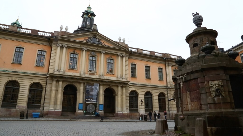
Nobel Museum in Stockholm, Sweden (Photo: Erik Olsen)
This is all about more than geography and climate (although those are a big sell, for sure). California’s research institutions kick ass because they operate as ecosystems rather than islands. Berkeley physicists collaborate with engineers at Stanford. Caltech chemists trade ideas with biotech firms in San Diego. Graduate students drift between labs, startups, and national research centers like Lawrence Livermore and JPL. The boundaries between university and industry blur, with campuses like Stanford turning breakthrough discoveries into thriving commercial ventures (look how many of our big tech brains came out of Stanford). In California, research doesn’t end in the lab, it often turns into companies, technologies, and treatments that generate both knowledge and enormous economic value. Just look at AI today.
Check out our Etsy store for cool California wildlife swag.
I think the secret is cultural. Over the years, I’ve lived on the East coast for almost two decades, and abroad for several as well, and nothing compares to the California vibe. California has never been afraid of big risks. Its scientists are encouraged to chase questions that might take decades to answer (see our recent story on just this idea). There’s an openness to uncertainty here that works well in the natural sciences, but can also be found in Hollywood, Silicon Valley and, of course, space exploration.
When next year’s round of early morning calls comes from Stockholm, it is a good bet that someone in California will pick up. Maybe a physicist in Pasadena, a chemist in Berkeley, or a physician in La Jolla. Maybe they’ll pick up the phone in bed, maybe a text from a spouse while camping, or on a morning jog. That’s when a Swedish-accented voice tells them that the world has just caught up to what they’ve been quietly building for years.
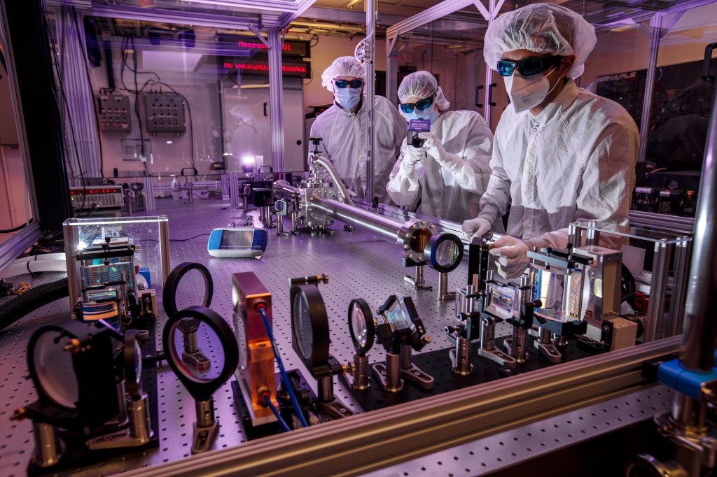
Researchers at Lawrence Livermore National Laboratory working with the Big Aperture Thulium (BAT) laser system, part of the laser and plasma research that laid the groundwork for generating the extreme ultraviolet light at the heart of today’s most advanced chipmaking machines. (Photo: Jason Laurea/LLNL)
When I started this Website, my hope was to share California’s astonishing range of landscapes, laboratories, and ideas. This state is overflowing with scientific discovery and natural marvels, and I want readers to understand, and enjoy, how unusually fertile this state is for discovery. If you’re not curious about the world, then this Website is definitely not for you. If you are, then I hope you get something out of it when you step outside and look around.
I spend a lot of time in the California mountains and at sea, and I am endlessly amazed by the natural world at our doorstep. I am also fascinated by California’s industrial past, the way mining, oil, and agriculture built its wealth, and how it later became a cradle for the technologies and industries now driving human society forward. Of course, some people see technologies like gene editing and AI as existential risks. I’m an optimist. I see tools that, while potentially dangerous, used wisely, expand what is possible.
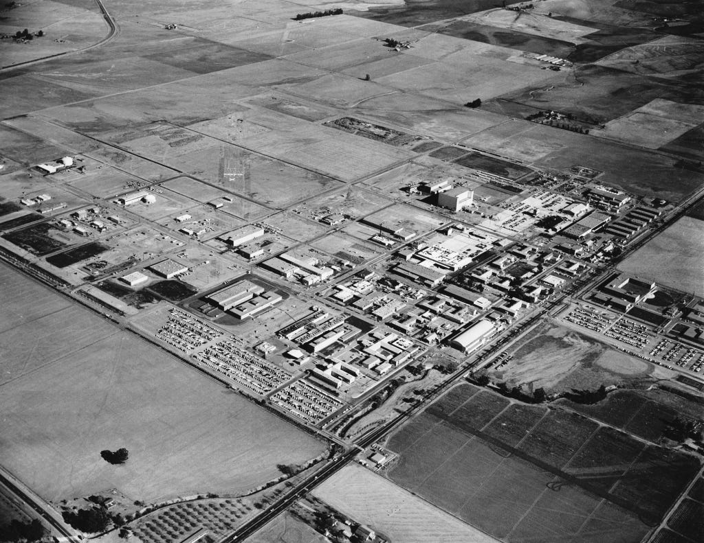
An aerial view of Lawrence Livermore National Laboratory in 1960, when the Cold War spurred rapid expansion of America’s nuclear and scientific research campus east of San Francisco Bay. (Photo: LLNL Public Domain)
Today’s story turns toward technology, and one breakthrough in particular that has reshaped the modern world. It is not just in the phone in your pocket, but in the computers that train artificial intelligence, in advanced manufacturing, and in the systems that keep the entire digital economy running. The technology is extreme ultraviolet lithography (EUV). And one of the most important points I want to leave you with is that the origins of EUV are not found in Silicon Valley startups or corporate boardrooms but in California’s national laboratories, where government-funded science made the impossible possible.
This article is not a political argument, though it comes at a time when government funding is often questioned or dismissed. My purpose is to underscore how much California’s national labs have accomplished and to affirm their value.
This story begins in the late 1980s and 1990s, when it became clear that if Moore’s Law was going to hold, chipmakers would need shorter and shorter wavelengths of light to keep shrinking transistors. Extreme ultraviolet light, or EUV, sits way beyond the visible spectrum, at a wavelength far shorter than ordinary ultraviolet lamps. That short wavelength makes it possible to draw patterns on silicon at the tiniest scales…and I mean REALLY tiny.
Ernest Orlando Lawrence at the controls of the 37-inch cyclotron in 1938. A Nobel Prize–winning physicist and co-founder of Lawrence Livermore National Laboratory, Lawrence’s legacy in nuclear science and high-energy research paved the way for the laboratory’s later breakthroughs in lasers and plasma physics — work that ultimately fed into the extreme ultraviolet light sources now powering the world’s most advanced chipmaking machines. (LLNL Public Domain)
At Lawrence Berkeley National Laboratory, researchers with expertise in lasers and plasmas were tasked with figuring out how to generate a powerful, reliable source of extreme ultraviolet light for chipmaking. Their solution was to fire high-energy laser pulses at microscopic droplets of tin, creating a superheated plasma that emits at just the right (tiny) wavelength for etching circuits onto silicon.
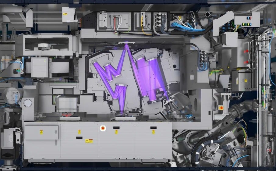
The movement of light on mirrors in an ASML EUV lithography machine. More on it below.
Generating the light was only the first step. To turn it into a working lithography system required other national labs to solve equally daunting problems. Scientists at Berkeley’s Center for X Ray Optics developed multilayer mirrors that could reflect the right slice of light with surprising efficiency. A branch of Sandia National Laboratories located in Livermore, California, worked on the pieces that translate light into patterns. So, in all: Livermore built and tested exposure systems, Berkeley measured and perfected optics and materials, and Sandia helped prove that the whole chain could run as a single machine.
Each EUV lithography machine is about the size of a bus, costs more than $150 million, and shipping one requires 40 freight containers, three cargo planes, and 20 trucks. (Photo: ASML)
It matters that this happened in public laboratories. The labs had the patient funding and the unusual mix of skills to attempt something that might not pay off for many years. The Department of Energy supported the facilities and the people. DARPA helped connect the labs with industry partners and kept the effort moving when it was still risky. There was no guarantee that the plasma would be bright enough, that the mirrors would reflect cleanly, or that the resists (the light-sensitive materials coated onto silicon wafers) would behave. The national labs could take that on because they are designed to tackle long horizon problems that industry would otherwise avoid.
Only later did private industry scale the laboratory breakthroughs into the giant tools that now anchor modern chip factories. The Dutch company ASML became the central player, building the scanners that move wafers with incredible precision under the fragile EUV light. Those systems are now capable of etching transistor features as small as 5 nanometers…5 billionths of a meter. You really can’t even use the “smaller than a human hair” comparison here since human hair variation is so large at this scale as to render that comparison kind of useless. However, many people still do.
The ASML machines are marvels of tech and engineering. Truly amazing feats human design. And they integrate subsystems from all over the world: Zeiss in Germany manufactures the mirrors, polished to near-atomic perfection, while San Diego’s Cymer (now part of ASML) supplies the laser-driven plasma light sources. The technology is so complex that a single scanner involves hundreds of thousands of components and takes months to assemble.
ASML’s EXE:5000 High-NA EUV lithography machine — a room-sized tool that etches the tiniest features on the world’s most advanced computer chips. (ASML)
It was TSMC and Samsung that then poured billions of dollars into making these tools reliable at scale, building the factories that now turn EUV light into the chips powering AI and smartphones and countless other devices. Trillions of dollars are at stake. Some say the fate of humanity lies in balance should Artificial General Intelligence eventually emerge (again, I don’t say that, but some do). All of this grew from the ingenuity and perseverance, along with the public funding, that sustained these California labs.
It’s disappointing that many of the companies profiting most from these technological breakthroughs are not based in the United States, even though the core science was proven here in California. That is fodder for a much longer essay, and perhaps even for a broader conversation about national industrial policy, something the CHIPS Act is only beginning to deal with.
However, if you look closely at the architecture of those monster machines, you can still see the fingerprints of the California work. A tin plasma for the light. Vacuum chambers that keep the beam alive. Reflective optics that never existed at this level before EUV research made them possible.
A photorealistic rendering of an advanced microprocessor, etched in silicon with extreme ultraviolet light — the kind of breakthrough technology pioneered in U.S. national labs, but now fabricated almost entirely in Taiwan, where the future of digital society is being made.
We often celebrate garages, founders, and the venture playbook. Those are real parts of the California story. This is a different part, just as important. The laboratories in Livermore, Berkeley, and Sandia are public assets. They exist because voters and policymakers chose to fund places where hard problems can be worked on for as long as it takes. The payoff can feel distant at first, then suddenly it is in your pocket. Like EUV. Years of quiet experiments on lasers, mirrors, and materials became the hidden machinery of the digital age.
Southern California’s beaches are a miracle. More than just landscapes, they’re cultural treasures. In movies, ads, and music, the coastline often feels like its own character. To many of us who live here, the coastline is not just a place to swim or sunbathe but a symbol of freedom, fun, and the state’s enduring connection to the Pacific Ocean.
And let’s face it, the beach would not be the beach without sand.
Pick up some California wildlife gifts at our Etsy store. Seriously, they’re cool.
I didn’t realize how essential sand is until I read Vince Beiser’s The World in a Grain. It quickly became one of my favorite nonfiction books in recent years … and I read a lot of nonfiction. Think about it: without sand, there would be no roads, no skyscrapers, no glass. That means no windows, no windshields, no microscopes or telescopes. No fiber-optic cables. No computer chips, since silicon, the foundation of modern technology, is essentially refined sand. The list is endless. I get that it’s not all beach sand per se, but that’s a quibble.
However, that’s not what I want to focus on here. What struck me, as I was walking along the beach the other day, was a simpler question: where does all the sand on Southern California’s beaches actually come from?
San Gabriel Mountains (Photo: Erik Olsen)
Well, put yourself for a moment on the beach in Southern California. No shoes. It turns out most of the grains between your toes actually began their journey high in the mountains above LA, on craggy slopes far from the shore. Mostly, we are talking about the San Gabriel Mountains and other peaks in the Transverse Ranges that run east-west across Southern California. The rugged, crumbling peaks are made of granite and other crystalline rocks rich in quartz, feldspar, and mica. Through the relentless process of erosion, wind and rain loosen these minerals, which tumble into streams and rivers, such as the San Gabriel and Santa Ana and are carried out to sea. During storms, torrents of sediment rush downhill toward the coast, and that’s where ocean currents take over.
This region where wave action dominates is called the littoral zone (no, not the literal zone), and it is where sand gets pushed around through a process known as longshore drift. Waves arriving at an angle push sediment along the shore, creating a conveyor belt that can carry grains for miles.
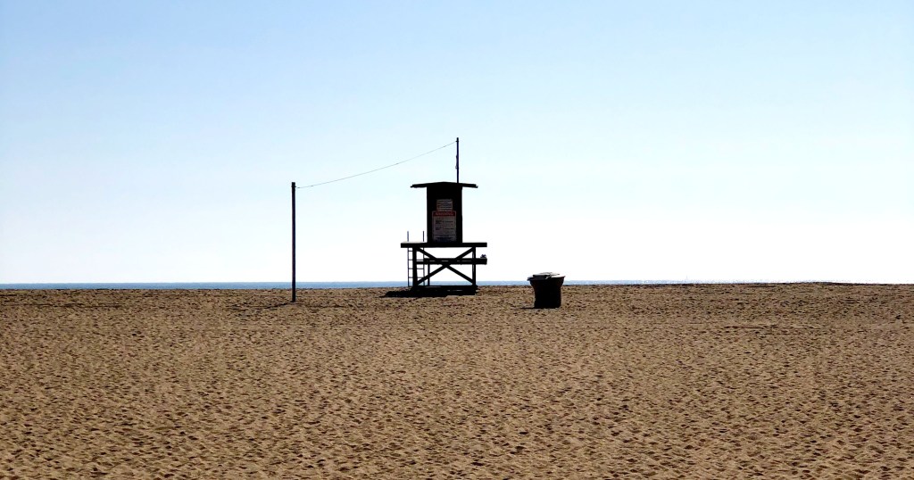
Lifeguard tower in Southern California (Photo: Erik Olsen)
In Southern California, this natural process has been reshaping the shoreline for thousands of years, constantly adding sand to some beaches while stripping it away from others. A lot has changed recently though (I mean “recent” in geologic terms). Humans, as we often do, have f*cked things up a bit, changing the nature of our beaches since the late 1800s. The piece I wrote recently about the Wedge in Newport is a good example. Breakwaters and other “shoreline armoring” built along our coast have altered the movement of sand, sending much of it into deep water where it is lost.
Dams have also cut off a huge portion of sediment that would once have reached the coast, reducing Southern California’s natural sand supply by nearly half. To make up the difference, beach managers spend millions each year dredging sand from offshore deposits or harbor entrances and pumping it onto the shore. We’ve been doing this for nearly a century. Between 1930 and 1993, more than 130 million cubic yards of sand were placed on Southern California beaches, creating wide stretches like Santa Monica and the Silver Strand that are much larger today than they would have been naturally. And if you think this is a temporary thing, forget it. With climate change driving stronger storms and rising seas, the need to keep replenishing sand is only going to grow.
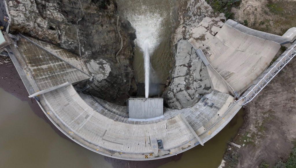
Big Tujunga Dam in Southern California (Photo: Erik Olsen)
For decades, geologists believed that rivers supplied as much as 90 percent of California’s beach sand. That view has shifted. Research from Scripps Institution of Oceanography shows that coastal cliffs also play a huge role on some beaches. Along the stretch from Dana Point to La Jolla, cliff erosion has been shown to contribute about half of the beach-sized sediment, and in some places up to 68 percent. This is especially true in dry years, when rivers deliver less. Still, on a statewide scale, rivers remain the main suppliers of sand. Studies from the California Coastal Sediment Management Workgroup show that, under present conditions, rivers account for about 90 percent of sand reaching Southern California beaches, with bluff erosion contributing roughly 10 percent.
Littoral cells in Southern California (Source: California Coastal Commission)
The sand’s story does not end at the shoreline. California’s coast is divided into littoral cells, essentially self-contained systems with their own sand sources, transport pathways, and sinks. Most sand in Southern California moves north to south, carried by waves arriving from the northwest. Eventually, much of it is lost into submarine canyons like Mugu, Newport, and Redondo, where it drops into deep water and exits the system.
Beach sand can also come from more subtle sources. Shell fragments from marine life, volcanic ash from distant eruptions, and even windblown desert dust can mix into the sediment. Perhaps not surprisingly, in recent decades, scientists have discovered another ingredient in our sand: plastic. Studies at Point Reyes and Golden Gate National Parks found an average of about 140 microplastic particles per kilogram of beach sand, which works out to roughly 50 pieces in a single measuring cup. Even beaches farther south, like Cabrillo, average nearly 40 pieces per kilogram.
Staff collect sand samples at Cabrillo National Monument. Testing revealed that Cabrillo sand had the lowest average concentration of microplastics of all of the West Coast parks studied. Point Reyes and Golden Gate had the highest. (Photo: National Park Service)
Offshore sediment cores show that microplastic deposition has doubled every 15 years since the 1940s, with most fragments being synthetic fibers shed from clothing. These findings show that California’s sand is no longer entirely natural; it now carries the pernicious imprint of modern consumer life, with fragments of plastic woven into its mix of minerals and shells. Interestingly, the concentration of microplastics off the coast of California, where researchers carried out their studies, appears to be lower than in many other parts of the world. “If they were doing the same thing in the Yellow Sea in China, right outside some of the big rivers like the Yangtze and Yellow River, the concentrations would probably be huge and cause adverse effects,” University of Michigan eco-toxicologist Allen Burton told Wired Magazine.
But look, the chance to walk or run on the beach is one of the real gifts of living in California. The sand that sticks to your towel, finds its way into your shoes, or gets stuck into your hair has traveled a long, remarkable journey to reach the shore. It’s true that some of it now includes plastic, which is unfortunate, but that doesn’t diminish the joy of being at the beach. In a world where so much feels fast, fleeting, and digital, there’s something really cool and satisfying about putting your toes in the sand, a remarkable substance that is totally crucial to modern civilization, yet which is also timeless and ancient and part of the natural world around us.
Ghost lobster trap off Santa Cruz Island in California’s Channel Islands (Photo: Erik Olsen)
Lobster is delicious. Let’s just get that out of the way. Yes, I’m sure there are some who either don’t enjoy the taste of this prolific crustacean, or who are allergic, but for my part, lobster (with a small vial of melted butter) is ambrosia from the sea.
But beyond its place on the plate, the California spiny lobster plays a vital ecological role: hunting sea urchins, hiding in rocky reefs, and helping to keep kelp forests in balance. Its value extends far beyond what it fetches at market. But beneath the surface, particularly around the Channel Islands lurks a growing problem that doesn’t just threaten lobsters. It threatens the entire marine ecosystem: ghost traps.
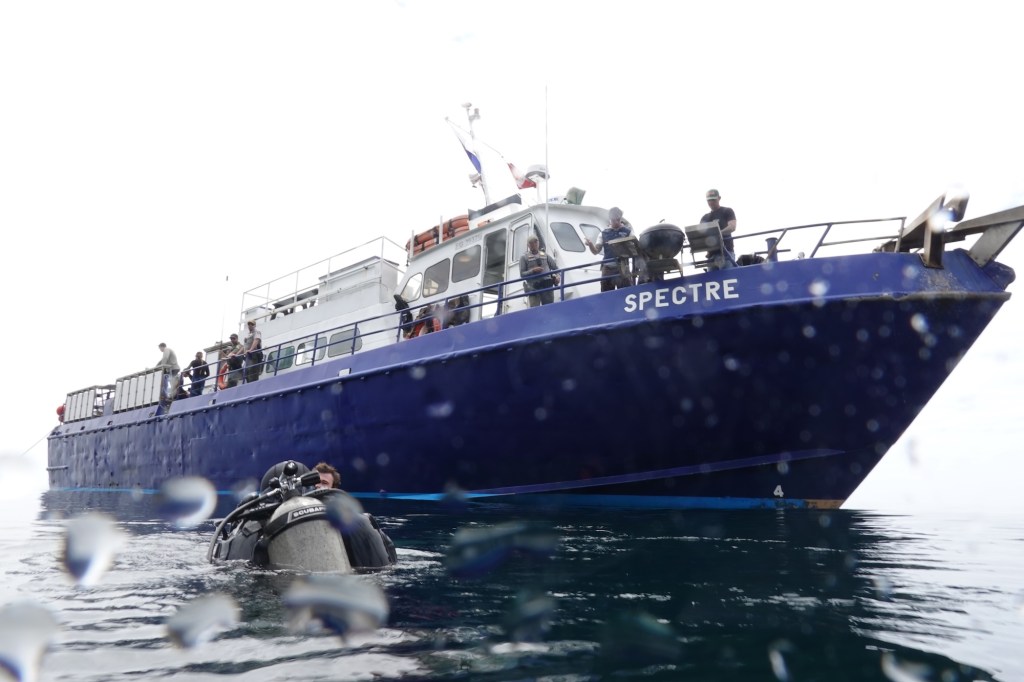
Dive ship Spectre off of Anacapa Island in California’s Channel Islands (Photo: Erik Olsen)
In Southern California, lobster fishing is both a cultural tradition and a thriving industry, worth an estimated $44 million annually to California’s economy from commercial landings as well as recreational fishing, tourism, and seafood markets.
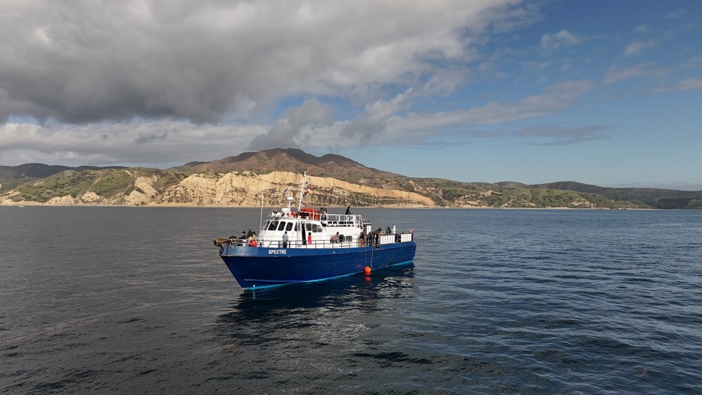
In late April, I traveled to the Channel Islands with my colleague Tod Mesirow to see the problem of ghost lobster traps firsthand. We were aboard the Spectre dive ship and pulled out of Ventura Harbor on an overcast morning, the sky a uniform gray that blurred the line between sea and cloud. The swell was gentle, but the air carried a sense of anticipati on. We were invited by the Benioff Ocean Science Laboratory, which is conducting research and outreach in the area. Our visit took us to Anacapa and Santa Cruz Islands, where I would be diving to observe the traps littering the sea floor. Tod, meanwhile, remained topside, capturing footage and speaking with marine scientists. Even before entering the water, we could see the toll: frayed lines tangled in kelp, buoys adrift, and entire areas where dive teams had marked clusters of lost gear.
California spiny lobsters alive when the ghost trap was recovered (Photo: Erik Olsen)
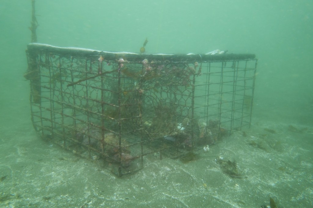
Ghost traps are lobster pots that have been lost or abandoned at sea. Made of durable metal mesh and often outfitted with bait containers and strong ropes, these traps are built to last. And they do. For years. Sometimes decades. The problem is, even when their human operators are long gone, these traps keep fishing.
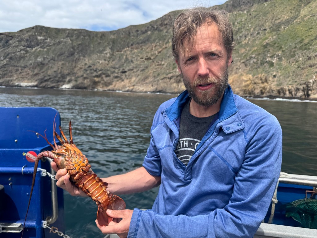
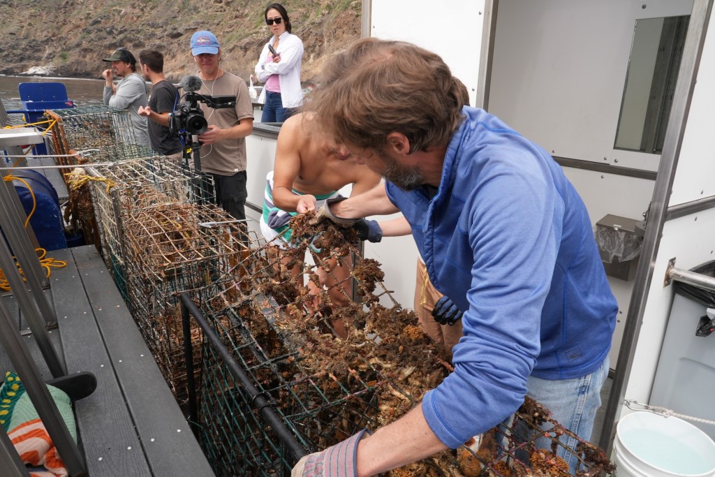
“It’s not uncommon to find multiple animals dead inside a single trap,” said Douglas McCauley, a marine science professor at UC Santa Barbara and director of the Benioff Ocean Science Laboratory who was onboard with us and leading the project. “It’s heartbreaking. These traps are still doing exactly what they were built to do, just without anyone coming back to check them.”
Douglas McCauley, director of the Benioff Ocean Science Laboratory at the University of California Santa Barbara holding a lobster caught in a ghost trap off the coast of the Channel Islands (Photo: Erik Olsen)
Around the Channel Islands National Marine Sanctuary, where fishing pressure is high and waters can be rough, thousands of traps are lost every season. Currents, storms, or boat propellers can sever buoys from their lines, leaving the traps invisible and unrecoverable. Yet they keep doing what they were designed to do: lure lobsters and other sea creatures inside, where they die and become bait for the next unfortunate animal. It’s a vicious cycle known as “ghost fishing.”
“They call them ghost traps because, like a ghost sailing ship, they keep doing their thing. They keep fishing.” said McCauley.
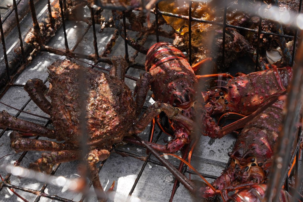
Statewide, the numbers are staggering. Approximately 6,500 traps are reported lost off the California coast each fishing season, according to The California Department of Fish and Wildlife. The folks at the Benioff Ocean Science Laboratory said as many as 6,000 may lie off the coast of the Channel Islands alone. Ocean Divers removing marine debris have found traps stacked three and four high in underwater ravines—rusting, tangled, but still deadly. These ghost traps don’t just catch lobsters; they also trap protected species like sheephead, cabezon, octopuses, and even the occasional sea turtle or diving seabird.
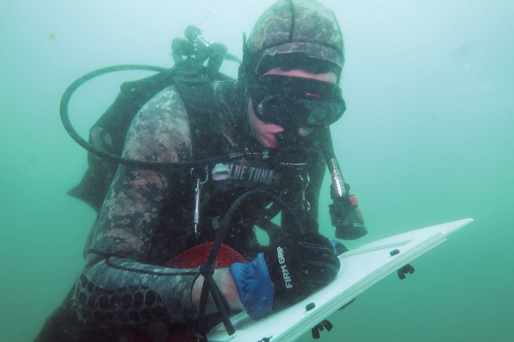
Diver and Project Scientist Chase Brewster of the Benioff Ocean Science Laboratory collecting data on ghost lobster traps near California’s Channel Islands (Photo: Erik Olsen)
Nowhere is this more evident than around the Channel Islands. These rugged islands are home to some of California’s richest kelp forests and underwater canyons. The islands and their surrounding waters are home to over 2,000 plant and animal species, with 145 of them being unique to the islands and found nowhere else on Earth. In fact, the Channel Islands are often referred to as North America’s Galapagos for the immense diversity of species here.
The islands are also the site of the state’s most productive spiny lobster fisheries. Every fall, hundreds of commercial and recreational fishers flood the area, setting thousands of traps in a race to catch California spiny lobsters (Panulirus interruptus). But rough swells and heavy gear mean traps go missing. Boats sometimes cut the lines of traps, making them near impossible to retrieve from the surface. And because this region is a patchwork of state waters, federal waters, and marine protected areas (MPAs), cleanup and regulation are anything but straightforward.
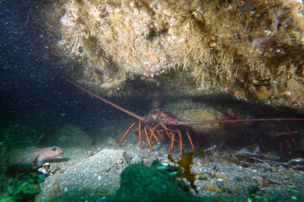
California Spiny Lobster off Anacapa Island (Photo: Erik Olsen)
The traps are often difficult to locate, partly because of their remote placement and the notoriously rough waters around the Channel Islands. But the Benioff Ocean Science Laboratory has a powerful asset: side scan sonar. From the ship, they can scan and map the seafloor, where the ghost traps often appear as dark, rectangular shapes against the sand. Once spotted, the team uses GPS to log their exact location.
“It’s creates a picture made of sound on the seafloor and you see these large lego blocks staring at you in bright yellow on the screen and those are your lobster traps,” sayd McCauley. “There’s nothing else except a ghost trap that looks like that.”
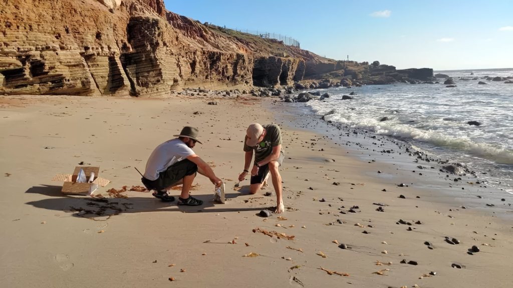
Plunging into the frigid waters off Santa Cruz Island was a jolt to the system. Visibility was limited, just 10 to 15 feet, but I followed two scientists from the Benioff Ocean Science Laboratory down to a depth of 45 feet. Their task: to attach a rope to the trap so it could be hauled up by the boat’s winch.
Dive ship Spectre off the coast of Santa Cruz Island in California’s Channel Islands (Photo: Erik Olsen)
The water was thick with suspended particles, the light dimming quickly as we dropped lower. My 7mm wetsuit was just barely enough to stave off the cold. On the seafloor, the ghost trap emerged, a large rectangular cage resting dark and ominous in the sand. And it was teeming with life. Fish darted around its edges, lobsters clambered along the frame, and inside, several animals moved about, trapped and slowly dying. It was easy to see how a single trap could wreak quiet havoc for years.
California law technically requires all lobster traps to include biodegradable “escape panels” with zinc hinges that degrade over time, eventually allowing trapped animals to escape. But enforcement is tricky, and the panels don’t always work as intended. In practice, many traps, especially older or illegally modified ones, keep fishing long after they should have stopped. That’s what we were out here to find.
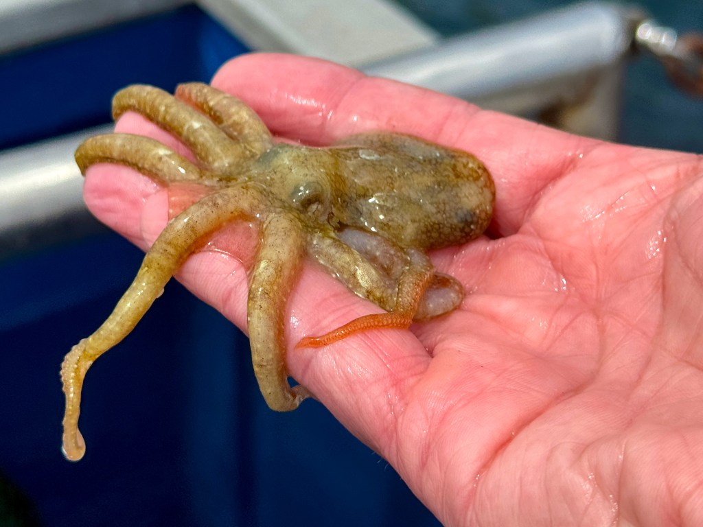
A baby octopus caught in a ghost trap in the waters off California’s Channel Islands (Photo: Erik Olsen)
Complicating matters is the fact that once a trap goes missing, there’s no easy way to retrieve it. Fishers are not legally allowed to touch traps that aren’t theirs, even if they’re obviously abandoned. And while a few small nonprofits and volunteer dive teams conduct periodic ghost gear removal missions, they can’t keep pace with the scale of the problem.
“At this fishery, we can’t get them all,” says McCauley. “But by going through and getting some species out and getting them back in the water, we’re making a difference. But in the process, we’re coming up with new ideas, new technologies, new research methods, which we think could play a role in and actually stopping this problem in the first instance.”
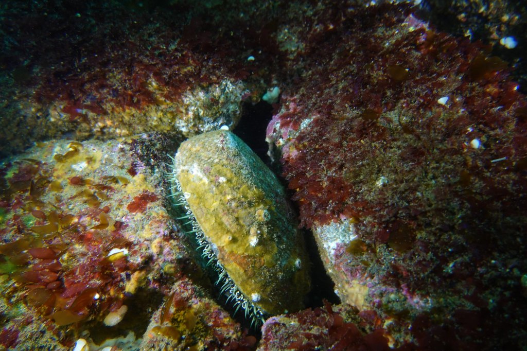
Once abundant along California’s coast, this large abalone spotted off Santa Cruz Island is a rare sight today—a quiet reminder of how overfishing, disease, and environmental change have decimated their populations. (Photo: Erik Olsen)
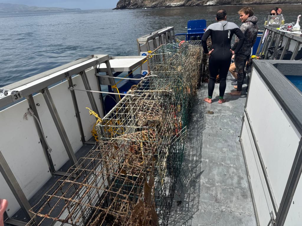
Back topside, the recovery team aboard the Spectre used a powerful hydraulic winch to haul the trap onto the deck. After climbing out of the cold water, still shivering, I joined the others to get a closer look. The trap was heavy and foul-smelling, but what stood out most was what was inside: lobsters, maybe ten or more. Some had perished, but many were alive and thrashed their tails when lifted by the scientists. Females could be identified by their broader, flatter tail fins—adapted to hold eggs. The team carefully measured each one before tossing them back into the sea, the lobsters flipping backward through the air and disappearing into the depths.
There were other animals, too. Large, rounded crabs known as Sheep crabs, common to these waters, scuttled at the bottom of the trap. Sea snails were clustered along the mesh, and in one cage, there were dozens of them, clinging and crawling with slow purpose. Even baby octopuses made appearances, slithering out onto the deck like confused aliens. I picked one up gently, marveling at its strange, intelligent eyes and soft, shifting forms, before tossing it back into the sea in hopes it would have another chance at life.
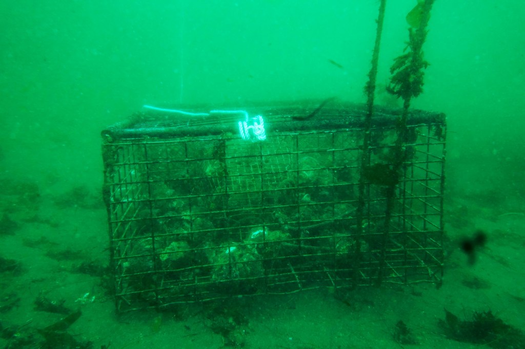
Ghost lobster trap lies on the seafloor off of Santa Cruz Island in California’s Channel Islands (Photo: Erik Olsen)
By then, the day had brightened and the sun had come out, easing the chill that lingered after the dive. The traps would be taken back to Ventura, where they’d likely be documented and disposed of. But this day wasn’t just about saving individual animals or pulling traps off the seafloor—it was about data. The Benioff team wants to understand just how big of a problem ghost traps really are. It’s not just about the number of traps lost each season, but the broader ecological toll: how many animals get caught, how many die, and how these traps alter the underwater food web. Every recovered trap adds a piece to the puzzle. This trip was about science as much as rescue.
State agencies, including the California Department of Fish and Wildlife (CDFW), have started pilot programs aimed at tackling ghost gear. In 2023, CDFW launched a limited recovery permit program that allows fishers to collect derelict traps at the end of the season, provided they notify the state. But participation is voluntary and poorly funded.
Elsewhere, states like Maine and Florida have created large-scale, state-funded programs to identify and remove ghost traps, often employing fishers in the off-season. California, despite having the nation’s fourth-largest lobster fishery, has yet to make a similar investment.
Ghost lobster traps recovered from the seafloor off the coast of California’s Channel Islands (Photo: Erik Olsen)
Some solutions are already within reach. Mandating GPS-equipped buoys for commercial traps could help track and retrieve gear before it’s lost. More robust escape hatch designs, made from materials that dissolve in weeks rather than months, would shorten the lifespan of a lost trap. And expanding retrieval programs with funding from fishing license fees or federal grants could make a big dent in ghost gear accumulation.
But even more powerful than regulation may be public awareness. Ghost traps are out of sight, but their damage is far from invisible. Every trap left behind in the Channel Islands’ waters becomes another threat to biodiversity, another source of plastic and metal waste, and another reminder that marine stewardship doesn’t stop when the fishing season ends.
Key to the whole effort is data:
“Every one of the animals that we put back in the water today, we’ll be taking a measure,” says McCauley. “After a little bit of crunching in the lab, we’ll be able to say, oh, actually, you know, every single trap undercuts the fishery by x percent for every single year that we don’t solve the problem.”
Doug McCauley with a lobster trap retrieved from the seafloor off the coast of California’s Channel Islands (Photo: Erik Olsen)
As we headed back toward Ventura, Tod and I talked with Douglas McCauley and Project Scientist Neil Nathan from the Benioff Ocean Science Laboratory. The team had collected a total of 13 traps that day alone, and 34 over the several days they’d been out. There was a sense of satisfaction on board, quiet but real. Each trap removed was a small win for the ecosystem, a little less pressure on an already strained marine environment.
“I would call today an incredible success, ” said Neil Nathan. “Feeling great about the number of traps we collected.”
California has long been a leader in ocean conservation. If it wants to stay that way, it needs to take ghost fishing seriously, not just around the Channel Islands, but up and down the coast. After all, we owe it to the lobsters, yes, but also to the underwater forests, reef communities, and countless species whose lives are tangled in the nets we leave behind.