JPL and the Voyager Golden Record: Humanity’s A Cosmic Mixtape in Space

The Jet Propulsion Laboratory (JPL) in La Canada Flintridge, California is well-known for building and sending spacecraft far into the cosmos to help us better understand the universe. But the agency was also extensively involved in one of the most ambitious and symbolic projects in the history of space exploration, one that in many ways was more art than science: the Voyager Golden Record.

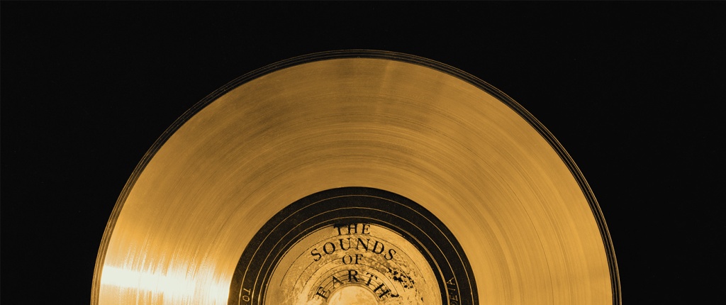
In 1977, as the twin Voyager spacecraft prepared to journey beyond the confines of our solar system, they carried with them what might be the most profound artifacts ever created by humanity: the Voyager Golden Records. These records, designed to last a billion years, are time capsules intended not for Earthlings but for potential extraterrestrial finders or future humans. Engraved in gold-plated copper discs, the records encapsulate the Earth’s diverse cultural and natural heritage—from music to languages to sounds of nature.

Photo: NASA/JPL-Cal Tech

The idea of the Golden Record was developed by a talented team led by Carl Sagan, the renowned astronomer and science communicator. Sagan, alongside other prominent figures such as Frank Drake, Ann Druyan, science journalist Jon Lomberg, and Linda Salzman Sagan, crafted a selection that aimed to represent the entirety of Earth. The content ranged from classical music by Bach and Beethoven to greetings in 55 languages, natural sounds like thunderstorms and whales, and a diverse set of 115 images depicting life and culture on Earth.

But producing a record that could survive the harsh environment of space, while also being understandable and playable by beings of unknown technology, posed unique challenges. This is where the Jet Propulsion Laboratory (JPL) stepped in, playing a pivotal role in transforming this ambitious vision into a tangible, durable artifact capable of traversing the cosmos.

Inspection of the engraving of the Voyager Golden Record.
Photo: NASA/JPL-Cal Tech

JPL, managed by Caltech under a NASA contract, was primarily responsible for the construction and operation of the Voyager spacecraft. Their expertise was crucial not just in the scientific instrumentation and engineering of the spacecraft but also in integrating the Golden Records. The lab’s engineers worked meticulously to ensure that the records were equipped with everything needed for potential playback: a cartridge, a needle, and symbolic instructions detailing their use. These instructions, etched onto the record’s cover, provided a universal map indicating Earth’s location in relation to pulsar stars, which are highly stable and can be used as galactic landmarks.

JPL’s involvement extended to the actual physical preparation of the records. They coordinated closely with RCA Records to produce the master disc from which the Voyager records were replicated. The final products were then plated in gold and encased in a protective aluminum jacket, designed to withstand the vacuum of space, cosmic rays, and extreme temperatures.

Photo: NASA/JPL-Cal Tech

The technical contributions of JPL ensured that the Golden Records were not only a feat of cultural expression but also a marvel of scientific and engineering ingenuity. By equipping the Voyager spacecraft with these messages, JPL helped bridge the human desire to explore and communicate with the tangible reality of space travel. The records, mounted aboard Voyagers 1 and 2, continue to be ambassadors of Earth, carrying sounds, music, and images intended to convey the story of our world to whoever, or whatever, might find them.

Today, both Voyager spacecraft, with their Golden Records, have entered interstellar space, marking them as the most distant human-made objects in existence. They serve as reminders of humanity’s ambition to reach beyond our immediate grasp and to communicate across vast cosmic distances. JPL’s role in this historic endeavor highlights the profound connection between human creativity and technological advancement, ensuring that our message to the cosmos will endure long after the original voices have faded.

JPL written on the Voyager Golden Record
Photo: NASA/JPL-Cal Tech

As these records voyage through the cosmos, they remind us not just of where we have been, but also of the far reaches that our curiosity can take us. Through the combined efforts of visionaries like Carl Sagan and the engineering prowess of JPL, the Voyager Golden Record stands as a testament to the best of human knowledge, culture, and technological achievement.


The Voyager Golden Records are phonograph records, much like the vinyl records used to listen to music before digital media became widespread. They are constructed from copper discs coated in gold to withstand the harsh environment of space. Each record is encased in a protective aluminum jacket, along with a cartridge and a needle. Instructions in symbolic language explain the origin of the spacecraft and indicate how the record should be played. The playback speed (16 2/3 revolutions per minute) is much slower than typical records, which typically spin at 33 1/3 or 45 rpm.

The content of the Golden Record is a meticulously curated selection intended to represent the diversity of life and culture on Earth:

Sounds of Earth: The records include audio of nature sounds like thunder, wind, and animals (including the songs of birds and whales). Human sounds like footsteps, a heartbeat, and laughter are also embedded, capturing the biological and social essence of Earth.

The DNA structure magnified, light hit image is one of the pictures electronically placed on the phonograph records which are carried onboard the Voyager 1 and 2 spacecraft. Credit: Jon Lomberg

Musical Selections: There are 27 musical tracks from different cultures and eras, ranging from classical pieces by Bach and Beethoven to traditional songs from various cultures, including a Navajo chant and a Peruvian wedding song. These selections were intended to showcase the diversity of musical expression on Earth.

Greetings in 55 Languages: A variety of spoken greetings from “Hello” in English to ancient languages like Akkadian. The inclusion of a broad range of languages aims to depict the linguistic diversity of humanity.

Images: The record also contains 115 analog-encoded photographs and diagrams. These images show a wide range of subjects, including humans of different sexes and races, everyday activities, scientific knowledge like mathematical definitions, and the Solar System. The intent was to offer a visual summary of our planet and its inhabitants.

CALIFORNIA CURATED ART ON ETSY

Purchase stunning art prints of iconic California scenes.
Check out our Etsy store.

Message from the UN Secretary-General and the President of the United States: There are also printed messages from prominent global leaders at the time, including U.S. President Jimmy Carter and United Nations Secretary-General Kurt Waldheim.

Sounds of Human Origin: Beyond natural and environmental sounds, the record also includes a montage of the sounds of Earth, a screaming chimpanzee, a medley of human-originated noises like tools, vehicles, and a kiss, among others.

The idea behind the Voyager Golden Record is not just to communicate where and who we are but also to share a message of hope and peace with any possible recipient, even if that recipient is far in the future. The chances of the Voyager spacecraft actually being found by extraterrestrial life are slim, but the Golden Record serves as a profound gesture of goodwill and a testament to the human spirit’s longing to reach out and explore the universe.

Feathers on the Flyway: Unraveling Avian Mysteries at Bear Divide with the Moore Lab

Western tanager (Ryan Terrill)

“Personally, I really think it’s one of the best birding spots in the world,” Ryan Terrill, science director at the Klamath Bird Observatory.

Within a 45 minute drive from the urban chaos of downtown Los Angeles, lies a natural, ornithological marvel: Bear Divide, a vital corridor for the annual migration of numerous bird species. Every year — roughly between March 15 and June 15, with peak migration between April 10 and May 20 — thousands of birds funnel through the narrow pass. The divide is a small dip in the otherwise impregnable San Gabriel mountains, allowing birds in the midst of their migration to pass through safely at relatively low altitudes. This area is not just a haven for bird enthusiasts but also a critical research site, especially for the team from the Moore Lab of Zoology at Occidental College, who have been delving into the intricacies of these migratory patterns.

The Moore Lab of Zoology is renowned for its extensive bird specimen collection, one of the largest of its kind in the world for Mexican birds.

Part of the large bird collection at the Moore Lab at Occidental College in Pasadena (Erik Olsen)

Bear Divide is strategically positioned along the Pacific Flyway, a significant north-south migratory route used by birds traveling between Alaska and Patagonia. The geographical features of the San Gabriels provide an ideal resting and feeding ground for these birds, making Bear Divide a crucial stopover during their long journeys. It’s this unique combination of location and topography that makes Bear Divide an essential component of avian migration.

U.S. Fish and Wildlife Service

The discovery of Bear Divide was a lucky happenstance. A bird researcher was conducting overnight monitoring in the spring of 2016, and when morning came, he noticed legions of small songbirds whizzing past his monitoring spot. His report caught the attention of postdoc bird scientist Ryan Terrill at Moore Lab at the time, and he began an effort to monitor the birds. Terrill and his team would ultimately record as many as 20,000 birds in a single morning.

“It really is overwhelming to stand on the road and have 5,000 birds of 80 species fly by your knees in a morning,” Terrill said. The effort has continued to this day with startling results. Terrill has since left and is now the science director at the Klamath Bird Observatory.

CALIFORNIA CURATED ON ETSY

Purchase stunning coffee mugs and art prints of iconic California species.
Check out our Etsy store.

“Last year 2023 we counted 53,511 birds of 140 species from February to May,” said John McCormack, a professor of biology and the Director and Curator of the Moore Laboratory of Zoology. “And of course, we missed many thousands more because most travel at night. It’s easy to say that there are hundreds of thousands of birds passing through Bear Divide.”

Swainson’s Hawk (Marky Mutchler)

As many as 13,000 western tanagers, lazuli buntings, chipping sparrows, hermit warblers, orioles, grosbeaks and warblers pass through Bear Divide on a single day. Why they do so, is not entirely understood. The unusual topography of Bear Divide essentially serves as a funnel for the migrating birds, with many of them shooting through the gap just a meter or two above ground.

“Personally, I really think it’s one of the best birding spots in the world,” Terrill told the LA Times.

McCormack says that the “ultimate goal is to better understand the Pacific Flyway and how it’s used, especially by small terrestrial birds. Little is known about their movements because they are hard to see and usually travel at night.”

Hooded Oriole (Ryan Terrill)

Because many of the species sighted at Bear Divide are in steep decline. The lab says that year-to-year counts will help set a baseline for future trends that can be associated with weather, climate, and urbanization. “Tracking individual birds will give granular knowledge on how migratory birds use the landscape, which helps individuals and homeowners create corridors for them to travel,” says McCormack.

The best time to catch the show at Bear Divide is late winter early Spring. McCormack says Cliff Swallows and Lawrence’s Goldfinch are some of the early movers in March, and that by May, streaking by are Yellow Warblers, sunset-faced Western Tanagers, and bright blue Lazuli Buntings.

“There is so much we still don’t know about these birds and their world,” Lauren Hill, the site’s lead bird bander, told the Los Angeles Times. “For example, no one knows where they were before showing up here after sunrise.”

Lazuli Bunting zips past the camera at Bear Divide (Ryan Terrill)

The team is counting birds in order to establish a baseline of the populations coming through Bear Divide so they can understand how much we are changing the environment and what effect that may have on bird populations, many of which are in severe decline.

Their research spans a variety of topics, including how climate change is impacting migration routes and the effects of urbanization on bird populations. The lab has recently begun a program to put satellite trackers on birds at Bear Divide to follow individual birds, providing deep insight into their migration and resting patterns. This research is not only pivotal in understanding avian behavior but also crucial in shaping conservation policies.

One of the most fascinating aspects of Bear Divide is the sheer variety of bird species it attracts. From the diminutive hummingbirds to the impressive birds of prey, each species adds a unique dimension to the study of migration. The Moore lab’s findings have shed light on the varied responses of different species to environmental changes, offering a glimpse into the broader ecological shifts occurring across the globe.

Yellow-rumped Warbler (Ryan Terrill)

One compelling result of the Moore Lab’s study at Bear Divide suggests that the peak of a particular species’ migration is correlated with the latitude of its breeding site. Species that breed at higher latitudes migrated through Bear Divide at later dates. It’s also unusual in the West for species to migrate during the day. Most species of birds using the Pacific Flyway are known to migrate at night.

The Moore Lab of Zoology

In addition to its scientific contributions, the Moore lab is also known for its involvement in citizen science. Collaborating with local birdwatchers and volunteers, the lab extends its research capabilities and cultivates a community actively engaged in bird conservation. This collaborative approach not only enhances the breadth of their research but also underscores the importance of community involvement in conservation efforts.

Bear Divide is on public land, so anyone with a legitimate research project can get permission to work there. UCLA graduate student Kelsey Reckling, who has worked as a counter at Bear Divide since the beginning, is leading the counting efforts this Spring to understand changes in numbers of birds and species across years. Cal State L.A. graduate student Lauren Hill lea ds the group of bird banders, who catch some of the birds and record data, attaching a lightweight metal band around one leg and releasing them. Her lab mate Tania Romero is putting small, lightweight tracking devices on Yellow Warblers, which send signals to a network of tracking (MOTUS) towers across the continent.

Many bird species are under serious threat around the globe from a number of different impacts, including climate change, pesticides and habitat loss. Birds play a critical role in the health of our planet. They regulate ecosystems by preying on insects, pollinating plants, and spreading seeds. Healthy ecosystems are important for breathable air, food, and a regulated climate.

Bear Divide (Ian Davies)

According to a 2019 study, nearly 3 billion breeding birds have been lost in North America and the European Union since 1970. That’s about 30% of the bird population in North America. The 2022 State of the Birds Report for the United States found that bird declines are continuing in almost every habitat, except wetlands. Protecting birds’ habitats, and migration routes and reducing mortality through conservation efforts are crucial to ensuring the survival of these magnificent creatures.

The research conducted at Bear Divide by the Moore lab transcends academic interests, emphasizing the interconnectivity of ecosystems and underscoring the need to preserve natural migration corridors amid urban expansion. The insights gained here are invaluable to both the scientific community and conservation efforts, highlighting the need for a balanced approach to wildlife preservation and ecological sustainability.

Band-tailed Pigeon (Ryan Terrill)

“What’s magical about Bear Divide is that it’s the first real place to see small, migrating birds at eye level in daylight hours,” says McCormack. “I don’t want to oversell it: it’s still a lot of small birds zinging by in a wide open place and it takes a while to get good at identifying them. But by seeing them out there, struggling against the wind and the cold, but still making progress, it gives you a real sense of how amazing their journeys are–and how we shouldn’t make them harder if there’s anything we can do about it.”

The Blythe Intaglios are the California’s Nazca Lines. They are True Mysteries Etched in Earth.

Blythe Intaglio of a human figure in Southern California (Wikipedia)

In the vast expanses of California’s Colorado Desert, less than four hours from Los Angeles, a series of ancient and enigmatic figures etched into the earth—the Blythe Intaglios—have long puzzled anthropologists and captivated the imagination of those who visit them or view them from the sky. They were brought to modern attention somewhat by chance. In 1932, George Palmer, a pilot flying over the Mojave Desert between Las Vegas, Nevada and Blythe, glimpsed these enigmatic formations, sparking curiosity and awe. 

Named for the nearby town of Blythe, California, these large geoglyphs (human-made designs created on the ground by arranging or moving objects in a landscape), sprawl across the desert floor, and are an extraordinary example of prehistoric art, yet they remain one of the lesser-known archaeological wonders of North America. The Colorado Desert, just south of the Mojave, contains the only known desert intaglios in North America. 

The Blythe Intaglios are best observed from above by drone or by plane, where their full scale and intricacy become apparent. The largest figure – of a human with outstretched arms – spans an immense 171 feet, an impressive endeavor considering the primitive tools likely used in their creation. One has to wonder why they were created at all since the people who made them certainly had no way of viewing them from the air. In addition to humans, the figures depict animals such as a rattlesnake and possibly a horse (yeah, what is that thing?), as well as geometric shapes, each meticulously carved by removing the dark desert varnish to reveal the lighter soil underneath. Intaglios in general are classified by their shapes, such as anthropomorphs (humanlike), zoomorphs (animal-like) and various geometric shapes.

Blythe Intaglio quadruped (Wikipedia)

The intaglios are mostly located along the Colorado River, a fact that some scientists consider significant. Rivers often hold a central place in the spiritual and cultural lives of indigenous peoples. For the tribes associated with the Blythe Intaglios, such as the Mojave and Quechan, the Colorado River was likely a vital part of their spiritual and everyday life. The proximity of these geoglyphs to the river suggests that they could have been part of a broader cultural landscape that included the river as a critical element. The river may have been seen as a source of life and a spiritual boundary, making the nearby land a significant place for creating these monumental figures.

While the Nazca Lines in Peru have gained worldwide fame, the Blythe Intaglios, though similar in form and function, have remained relatively obscure. Most Californians probably have no idea that such unique archaeological artifacts can be found in the state, let alone so close to a major urban center. This obscurity, however, adds to their mystique. 

The geoglyphs are believed to date back at least a thousand years, but their exact age remains uncertain. If the quadruped figures represent horses (reintroduced in North America by the Spanish) then a historical date of sometime after the 1500s would be supported. Archaeologist Jay von Werlhof obtained radiocarbon dates for the figures, ranging from 900 BCE to 1200 CE. The human figures, particularly the largest, are thought to represent Mastamho, the creator of life in Mojave and Quechan mythology. The animal figures, like the mountain lions, are steeped in symbolic meaning, potentially reflecting the tribes’ cosmology and spiritual beliefs.

Nazca Lines in Peru. (UNESCO World Heritage Site)

The precise purpose of the Blythe Intaglios is a matter of ongoing debate. Some scholars propose that they were part of religious rituals or celestial observances. The alignment and positioning of the figures suggest a possible astronomical function, marking significant events in the lunar or solar calendars. Or perhaps making them was just a fun way to pass the time and express creativity.  

CALIFORNIA CURATED ON ETSY

Purchase stunning coffee mugs and art prints of iconic California species.
Check out our Etsy store.

Despite their historical and cultural significance, the Blythe Intaglios have not been immune to threats. Off-road vehicle traffic and natural erosion have damaged some of the figures. Conservation efforts are in place, but the remote location and sheer scale of the site present unique challenges. Fences have been erected around some figures to protect them, but much work remains to ensure their preservation.

California’s Colorado Desert (Wikipedia)

The Blythe Intaglios are more than just ancient art; they are a wonderful example of the rich and diverse cultural heritage of the indigenous peoples of the Southwest. These geoglyphs offer a window into a past that likely predates European influence, a past that is integral to understanding the complex tapestry of American history. Places like the Blythe Intaglios are in constant threat of disappearing forever, but they’re important because they connect us with the human past and remind us of the power of human expression over time and the mysteries beneath our feet.

The Enigmatic Island Fox: A Tale of Survival and Conservation

Nature Conservancy

In the rugged, isolated beauty of California’s Channel Islands, a small, curious creature scampers through the chapparal, playing a crucial role in the archipelago’s ecosystem. It’s the Island Fox (Urocyon littoralis), a species that encapsulates both the vulnerability and resilience of island ecosystems.

The island fox only lives on six of the eight Channel Islands off the coast of southern California–they are found nowhere else on Earth. Each island population is recognized as a separate endemic or unique subspecies. This divergence is a classic case of allopatric speciation, where geographic isolation leads to the evolution of different species.

The Island Fox, notably smaller than its mainland cousin, the gray fox, stands as a striking example of insular dwarfism – a phenomenon found in the theory of island biogeography where species evolve smaller sizes on islands. It should be noted that island biogeography, which explores the distribution of species and ecosystems in island environments, finds a perfect case study in the Channel Islands. For instance, the discovery of remains of the pygmy mammoth (Mammuthus exilis) on Santa Rosa Island provides a classic example of how isolation and limited resources can lead to significant evolutionary changes. 

Skeleton of the Pygmy Mammoth at the Santa Barbara Museum of Natural History

The Island Fox is known for its curiosity and intelligence. It’s primarily nocturnal but is often active during the day, especially when tourists and their food are around. Visitors to the most popular Channel Islands like Anacapa, Santa Rosa, and Santa Cruz may regularly see the foxes scurrying around campsites looking for scraps of food. They readily approach humans, perhaps an unfortunate sign that they have become too habituated to humans. The island fox is an omnivore, with a diet ranging from fruits and insects to small mammals and birds. Its diet shifts with the seasons, reflecting the availability of different food sources on the islands.

Island Foxes typically form monogamous pairs during the breeding season, which runs from January to March. The female gives birth to a litter of two to four pups around 50 days after mating. These pups are weaned and ready to fend for themselves after about 9 months, reaching sexual maturity at 10 months. The average lifespan of an Island Fox in the wild is 4 to 6 years, though they can live longer in captivity.

Island Fox on the Channel Islands (Photo: Erik Olsen)

The story of the Island Fox’s conservation is one of remarkable success but also a stark reminder of the fragility of island ecosystems. In the late 1990s, the Island Fox population faced a catastrophic decline, primarily due to predation by golden eagles and a disease outbreak. By 2004, fewer than 100 foxes remained on some islands, leading to their classification as an endangered species.

Island Fox looking for food scraps. (Photo: Erik Olsen)

A concerted effort by conservationists, including the National Park Service and the Nature Conservancy, initiated a recovery program. This program involved breeding foxes in captivity, vaccinating them against diseases, and relocating golden eagles while reintroducing bald eagles, a natural competitor. Remarkably, by 2016, the Island Fox populations had bounced back sufficiently for them to be removed from the endangered species list, marking one of the fastest recoveries of an endangered species in U.S. history.

The Island Fox’s journey from the brink of extinction to a conservation success story is a testament to the power of dedicated conservation efforts. It also highlights the importance of maintaining ecological balance in sensitive environments like the Channel Islands.

The California Gull is the Unsung Hero of Feathered Adaptability and Ecological Balance

Imagine a bird that’s not only a reliable fixture on both coastal and inland landscapes, but also a winged hero with a knack for saving ecosystems and crops alike. Meet the California gull, a seemingly unassuming creature that’s the avian equivalent of a Toyota Camry: dependable, middle-of-the-road, and surprisingly full of stories. Far from just another seabird scrounging for scraps, this versatile gull is a fascinating study in adaptability, ecological impact, and even historical significance.

Birdwatching might be dismissed as a pedestrian hobby, but when you dive into the details, it’s a riveting blend of science, art, and natural history. Take the task of identifying a gull, for instance. You might think all gulls are created equal, but you’d be sorely mistaken. From the curvature of the bill to the tint of the feathers, each species presents its own unique set of traits. And in this realm, the California gull is the embodiment of middle-of-the-road reliability..

The California gull’s bill is a case study in avian averageness: not too long, not too short, but just right. Then there’s the back—a shade of gray that’s neither too dark nor too light. Size-wise, it’s comfortably nestled between the imposing giants and the pint-sized runts of the gull family. Even its legs are a kind of Goldilocks yellow—nothing too flashy or understated. The same goes for its migration pattern. This bird isn’t setting any long-distance records like the ambitious Arctic terns, nor is it stubbornly clinging to a single geographical point year-round. It moves around a reasonable amount—perhaps 500 to 1,000 miles—but always makes it back to familiar territory in good time.

California gull. (Larus californicus) Image: Wikipedia

And where might you spot this paragon of mediocrity? Well, in winter, they’re pretty much where you’d expect any self-respecting gull to be: on beaches, in harbors, hanging around landfills, playgrounds, and fields, or perhaps looking for morsels in tide pools and kelp beds. Come early summer, many venture inland to breed, but they generally make it back to their stomping grounds before the first school bell rings in September.

Yet for a bird that’s so unassuming, the California gull enjoys a surprising level of fame. Case in point: it’s the state bird of Utah, not California. That honor was bestowed upon it for its historical role during the initial Mormon settlement. The Sea Gull Monument in Salt Lake City honors the gull, who saved the people of Utah by consuming the Rocky Mountain crickets which were destroying all the crops in 1848. Quote from monument:

“The Mormon pioneers planted crops in the spring of 1848, after suffering great hunger during their first winter in the Salt Lake Valley. As the crops ripened, hordes of devouring crickets descended upon them from the foothills east of the valley. The Saints fought them with clubs, fire, and water. As they despaired of saving the next winter’s food, their prayers for deliverance from almost sure starvation were answered when thousands of sea gulls came to feed on the crickets. The Sea Gull Monument commemorates this modern-day miracle. The sea gull is now the Utah State bird.”

Sea Gull Monument in Salt Lake City (Wikipedia)

Moreover, the California gull has been an ecological hero in other ways. At Mono Lake in the Eastern Sierras of California, the gull has had a significant impact on bringing the lake back to life. (The lake is also known for its microbial aliens.) In the early part of the 20th century, Los Angeles’ voracious appetite for water led to shady deals by William Mulholland to secure access to Owens Lake. Declining water levels at Mono Lake threatened the gull population that nested there. But a decisive legal victory by the Save the Mono Lake Committee has ensured the lake is now maintained at healthier water levels, benefiting not just gulls but the entire ecosystem.

Mono Lake Photo: Erik Olsen

However, it’s not all sunny skies for this winged wonder. In the salt pans of South San Francisco Bay, the number of nesting California gulls has exploded—from a mere 24 nests in 1980 to a staggering 45,000 today. It’s a population boom that’s become a double-edged sword. With so many beaks to feed, the California gulls have taken to dining on their neighbors, including baby terns. This poses an ethical conundrum: when is it time to intervene and cull one species to protect another? A tough question—it’s a slippery slope that could eventually loop back to us humans, as we ponder our role in this intricately balanced web of life.

Hey there! If you enjoy California Curated, consider donating the price of a coffee to support its creation!

Through the Looking Glass Head: The Enigmatic World of the Barreleye Fish

The barreleye (Macropinna microstoma)
(Courtesy: Monterey Bay Aquarium Research Institute MBARI)

Off the coast of Monterey, California, researchers captured rare footage of one of the deep sea’s strangest residents: the Barreleye fish. With a see-through head and upward-facing, tube-shaped eyes, it looks like something dreamt up for a sci-fi film. Officially called Macropinna microstoma, this bizarre little fish is a real reminder of how much mystery still lies beneath the surface of the ocean and how otherworldly life can get down there.

First described in 1939, the fish astonished scientists who were stunned by its unique optical anatomy. The barreleye is found in the Pacific Ocean, with sightings ranging from the coasts of California, particularly around Monterey Canyon, to the mid-Pacific near Hawaii. Most commonly, it resides between 400 to 2,500 feet below the surface, a region known as the mesopelagic or “twilight” zone. At these depths, little light penetrates, making the area a seemingly inhospitable place for most life forms. But the Barreleye fish thrives here, adapting to its surroundings in the most bizarre ways.

Its most distinctive features, and the ones that give it its name, are its transparent head and barrel-shaped eyes that are usually directed upwards. These eyes are extremely sensitive to light, which is a scarce commodity where it lives. Interestingly, the eyes are encased in a dome-shaped, transparent head. This clear cranium allows the fish to capture as much light as possible, increasing its visual field. The upward-facing eyes allow the Barreleye fish to see silhouettes of prey or predators against the faint light filtering down from the surface. It’s like a built-in periscope for scanning the world above, allowing it to spot the bioluminescent glow of jellies or small fish that meander above it.

In 2009, researchers at the Monterey Bay Aquarium Research Institute elucidated a longstanding mystery surrounding the barreleye. For many years, marine biologists were under the impression that these specialized eyes were immobile and only provided the fish with a limited, tunnel-vision perspective, focused solely on the waters above its transparent head. Such a constraint would significantly limit the fish’s situational awareness, making it highly dependent on what occurs directly above it for both prey detection and predator evasion.

However, a groundbreaking paper by researchers Bruce Robison and Kim Reisenbichler overturned this conventional wisdom. Their findings reveal that the eyes of the barreleye fish are not static but can actually rotate within a transparent protective shield that envelops the fish’s head. This adaptation enables the fish not only to look upwards to identify potential prey but also to focus forward, thereby expanding its field of vision and facilitating more effective foraging.

A remotely operated vehicle or ROV named Doc Ricketts (MBARI)

Robison and Reisenbichler conducted their research using footage obtained from the Monterey Bay Aquarium Research Institute’s remotely operated vehicles (ROVs) to investigate the barreleye fish in the deep-sea regions adjacent to Central California. Situated at depths ranging from 600 to 800 meters (approximately 2,000 to 2,600 feet) beneath the ocean’s surface, the ROVs’ cameras typically captured images of these fish in a state of immobility, floating like zeppelins with their eyes radiating an intense green hue due to the illumination provided by the ROV’s powerful lighting system. The remotely captured video data also divulged a hitherto undocumented anatomical feature—namely, that the eyes of the barreleye fish are encased in a transparent, fluid-filled protective shield that encompasses the upper region of the fish’s cranial structure.

CALIFORNIA CURATED ON ETSY

Celebrate California’s incredible birdlife one mug at a time. Each design features a native species illustrated in vivid detail,
Check out our Etsy store.

The implications of this discovery extend beyond mere academic curiosity. Understanding the unique visual system of the barreleye fish provides crucial insights into the mechanisms of evolutionary adaptation. It showcases how even seemingly minor anatomical modifications can result in significant survival advantages in the highly competitive and challenging marine environment. Moreover, it challenges our existing perceptions and encourages scientists to revisit and reevaluate other long-standing assumptions in marine biology.

The Barreleye isn’t just a pair of eyes swimming around in the ocean, though. It has a suite of other adaptations to its challenging environment. For instance, it has large, flat fins that let it remain almost motionless in the water, conserving energy in an environment where every calorie counts. Also, it’s got a small mouth. This mouth is adapted to consume tiny organisms, like zooplankton, that are abundant in the deep ocean. So while the Barreleye may not be the apex predator down there, it has carved out its own unique niche.

Monterey Bay Aquarium Research Institute (MBARI) in Moss Landing, California

The fish also has what are called “lateral line canals” that are filled with fluid and are sensitive to changes in pressure. This allows the Barreleye to detect movement in the water, effectively giving it a “sixth sense” to sense prey or predators around it. Imagine you’re trying to navigate a pitch-black room—every little bit of extra information helps.

Despite its enigmatic nature, we know relatively little about its breeding habits, lifespan, or social interactions. Part of the reason is the difficulty in studying a creature that lives in such an extreme environment. Researchers have managed to capture only a few specimens, and observations in their natural habitat are relatively scarce.

While the Barreleye fish might look like a figment of a wild imagination, it’s very much a real creature, adeptly adapted to its harsh surroundings. It represents the myriad ways life can evolve to meet the unique challenges of extreme environments. As we continue to explore the depths of our oceans, who knows what other fantastical creatures we might find? That said, the Barreleye fish remains one of the most compelling arguments for the strange and wondrous biodiversity hidden in the ocean’s twilight zone, a testament to the endless creativity of evolution.

The Ocean’s Invisible Elevator: How Upwelling Fuels California’s Marine Bounty

The Vital Role of Upwelling in California’s Rich Ocean Life

Few marine processes have been as impactful on the abundance of sea life off the coast of California as upwelling. It may not be a term you’ve heard before, but the natural oceanic process of upwelling is one of the most important engines driving climate, biological diversity, and the ocean’s food web. It’s time to pay attention.

In simple terms, upwelling happens when deep, cold, nutrient-laden water moves toward the ocean surface, replacing the warm surface water. Along the California coast, it’s fueled by the California Current, which flows southward, and by prevailing northerly winds. The wind pushes surface water offshore, allowing the deeper water to well up and take its place. This isn’t just an abstract idea; it’s been studied extensively.

In California, upwelling occurs year-round off the northern and central coast. It’s strongest in the spring and summer when northwesterly winds are at their most powerful. Upwelling is reduced in the fall and winter when winds are more variable.

Killer whales benefit from upwelling because the nutrient-rich waters fuel a surge in phytoplankton, which triggers an increase in the populations of smaller prey fish and marine mammals that orcas rely on for sustenance. (Photo: NOAA)

Researchers from institutions like the Scripps Institution of Oceanography and Stanford University have used a variety of methods, including satellite observations and computer modeling, to study upwelling. One of the groundbreaking studies was the CalCOFI program (California Cooperative Oceanic Fisheries Investigations), which began in the late 1940s. It was a joint venture between Scripps and state and federal agencies to investigate the collapse of the sardine fishery. Over decades, it has expanded its scope and now provides invaluable long-term datasets that help scientists understand the dynamics of upwelling and its effects on marine populations.

CALIFORNIA CURATED ART ON ETSY

Purchase stunning art prints of iconic California scenes.
Check out our Etsy store.

The key to understanding the phenomenon of upwelling off the California coast begins with the importance of cold water. In colder regions, nutrients from the deeper layers of the ocean are more readily brought to the surface through various oceanic processes like upwelling, tidal action, and seasonal mixing.

Think of a well-fertilized garden versus a nutrient-poor one. In the former, you’d expect a lush array of plants that not only thrive, but also support a diversity of insect and animal life. Similarly, the nutrient-rich cold waters support “blooms” of phytoplankton, a critical component of the oceanic food web. Phytoplankton are microscopic, photosynthetic organisms that form the foundation of aquatic food webs, producing oxygen and serving as a primary food source for marine life. When these primary producers flourish, it sets off a chain reaction throughout the ecosystem. Zooplankton (tiny ocean-borne animals like krill) feast on phytoplankton, small fish feast on zooplankton, and larger predators, including larger fish, marine mammals, and seabirds, find an abundant food supply in these teeming waters.

Moreover, cold water has a higher capacity to hold dissolved gases like oxygen compared to warm water (one of the reasons that warming seas could be a problem in the future). Oxygen is a key factor for respiration in marine animals. In cold, oxygen-rich environments, organisms can efficiently carry out metabolic processes, which often results in higher rates of feeding, growth, and reproduction, thereby further boosting biological productivity.

A recent study has also shed light on how California’s rich marine ecosystem responds to climate patterns, particularly the El Niño and La Niña phases of the El Niño/Southern Oscillation (ENSO). Scientists found that during El Niño events, warmer waters and weaker upwelling lead to reduced nutrient levels in the California Current, which supports less phytoplankton and affects the entire food web, including fish populations. In contrast, La Niña conditions boost upwelling, bringing nutrient-rich waters to the surface and enhancing marine productivity. This research highlights the far-reaching impacts of climate cycles on ocean life and could help in forecasting changes that affect fisheries and marine biodiversity in California.

Sardines off the coast of California (Photo: NOAA)

Studies have also shown the direct correlation between the intensity of upwelling and the success of fish populations. A study published in the journal “Science Advances” in 2019 explored how variations in upwelling affect the foraging behavior and success of California sea lions. Researchers found that in years with strong upwelling, sea lions didn’t have to travel as far to find food, which, in turn, positively impacted their population’s health.

Upwelling is a critical oceanic process that helps maintain the stable and immensely productive California marine ecosystem, but there are serious concerns that the dynamics behind upwelling could be changing due to climate change.

Of course, upwelling isn’t just a California thing; it’s a global phenomenon that occurs in various parts of the world, from the coasts of Peru to the Canary Islands. But California is like the poster child, thanks to extensive research and its vital role in a multi-billion dollar fishing industry that includes coveted species like albacore tuna, swordfish, Dungeness crab, squid, and sardines.

Inspiration Point Channel Islands (Photo: NPS)

The Channel Islands provide an excellent example of a place off the California coast where the impacts of upwelling and ocean currents are particularly significant. Channel Islands National Park is uniquely located in a “transition zone” of less than 100 km where many ocean currents converge. This results in strikingly different ocean conditions at individual islands and affects where different species are found and how abundant they are.

Long-term studies of upwelling and the California Current system have shed further light on the importance of these complex and ever changing phenomenon. For example, the annual California Current Ecosystem Status Report captures the big picture of the biology, climate, physical, and social conditions of the marine ecosystem. In 2021, the California Current continued a recent cooling trend, with researchers recording the coldest conditions on the continental shelf in nearly a decade. These cooler coastal waters resulted from strong wind-driven upwelling—nutrient-rich, deep ocean water coming to the surface.

Sea surface temperature anomalies across the northeastern Pacific in August, 2019. A marine heat wave spread across the northeastern Pacific Ocean from 2014 to 2016 and the expanse of warm surface water returned to the region in 2019. (NASA Earth Observatory)

But things have grown more precarious in the north and out to sea. For the last ten years, the northeast Pacific Ocean has been a hotspot for marine heatwaves. Just this past year, scientists monitored the seventh most intense marine heatwave in this region since records began in 1982. However, there was a twist in the tale: unlike in previous years, the elevated water temperatures remained further offshore, a phenomenon partly attributable to stronger-than-average coastal upwelling. As a result, the strip of waters closer to the coast was able to maintain its cooler temperatures, thereby preserving a productive environment for marine life.

Visit the California Curated store on Etsy for original prints showing the beauty and natural wonder of California.

Upwelling is a critical oceanic process that helps maintain the stable and immensely productive California marine ecosystem, but there are serious concerns that the dynamics behind upwelling could be changing due to climate change. Warming ocean temperatures and changes in wind patterns could potentially disrupt the timing and intensity of upwelling, putting the bounty of California’s coast at risk.

Understanding these shifts is imperative for devising strategies to mitigate adverse effects on marine life and commercial fisheries. Therefore, sustained research efforts must continue to dissect this complex (and incredibly important) oceanic process and its increasingly uncertain future.