Imagine a bird that’s not only a reliable fixture on both coastal and inland landscapes, but also a winged hero with a knack for saving ecosystems and crops alike. Meet the California gull, a seemingly unassuming creature that’s the avian equivalent of a Toyota Camry: dependable, middle-of-the-road, and surprisingly full of stories. Far from just another seabird scrounging for scraps, this versatile gull is a fascinating study in adaptability, ecological impact, and even historical significance.
Birdwatching might be dismissed as a pedestrian hobby, but when you dive into the details, it’s a riveting blend of science, art, and natural history. Take the task of identifying a gull, for instance. You might think all gulls are created equal, but you’d be sorely mistaken. From the curvature of the bill to the tint of the feathers, each species presents its own unique set of traits. And in this realm, the California gull is the embodiment of middle-of-the-road reliability..
The California gull’s bill is a case study in avian averageness: not too long, not too short, but just right. Then there’s the back—a shade of gray that’s neither too dark nor too light. Size-wise, it’s comfortably nestled between the imposing giants and the pint-sized runts of the gull family. Even its legs are a kind of Goldilocks yellow—nothing too flashy or understated. The same goes for its migration pattern. This bird isn’t setting any long-distance records like the ambitious Arctic terns, nor is it stubbornly clinging to a single geographical point year-round. It moves around a reasonable amount—perhaps 500 to 1,000 miles—but always makes it back to familiar territory in good time.
California gull. (Larus californicus) Image: Wikipedia
And where might you spot this paragon of mediocrity? Well, in winter, they’re pretty much where you’d expect any self-respecting gull to be: on beaches, in harbors, hanging around landfills, playgrounds, and fields, or perhaps looking for morsels in tide pools and kelp beds. Come early summer, many venture inland to breed, but they generally make it back to their stomping grounds before the first school bell rings in September.
Yet for a bird that’s so unassuming, the California gull enjoys a surprising level of fame. Case in point: it’s the state bird of Utah, not California. That honor was bestowed upon it for its historical role during the initial Mormon settlement. The Sea Gull Monument in Salt Lake City honors the gull, who saved the people of Utah by consuming the Rocky Mountain crickets which were destroying all the crops in 1848. Quote from monument:
“The Mormon pioneers planted crops in the spring of 1848, after suffering great hunger during their first winter in the Salt Lake Valley. As the crops ripened, hordes of devouring crickets descended upon them from the foothills east of the valley. The Saints fought them with clubs, fire, and water. As they despaired of saving the next winter’s food, their prayers for deliverance from almost sure starvation were answered when thousands of sea gulls came to feed on the crickets. The Sea Gull Monument commemorates this modern-day miracle. The sea gull is now the Utah State bird.”
Moreover, the California gull has been an ecological hero in other ways. At Mono Lake in the Eastern Sierras of California, the gull has had a significant impact on bringing the lake back to life. (The lake is also known for its microbial aliens.) In the early part of the 20th century, Los Angeles’ voracious appetite for water led to shady deals by William Mulholland to secure access to Owens Lake. Declining water levels at Mono Lake threatened the gull population that nested there. But a decisive legal victory by the Save the Mono Lake Committee has ensured the lake is now maintained at healthier water levels, benefiting not just gulls but the entire ecosystem.
Mono Lake Photo: Erik Olsen
However, it’s not all sunny skies for this winged wonder. In the salt pans of South San Francisco Bay, the number of nesting California gulls has exploded—from a mere 24 nests in 1980 to a staggering 45,000 today. It’s a population boom that’s become a double-edged sword. With so many beaks to feed, the California gulls have taken to dining on their neighbors, including baby terns. This poses an ethical conundrum: when is it time to intervene and cull one species to protect another? A tough question—it’s a slippery slope that could eventually loop back to us humans, as we ponder our role in this intricately balanced web of life.
Off the coast of Monterey, California, researchers captured rare footage of one of the deep sea’s strangest residents: the Barreleye fish. With a see-through head and upward-facing, tube-shaped eyes, it looks like something dreamt up for a sci-fi film. Officially called Macropinna microstoma, this bizarre little fish is a real reminder of how much mystery still lies beneath the surface of the ocean and how otherworldly life can get down there.
First described in 1939, the fish astonished scientists who were stunned by its unique optical anatomy. The barreleye is found in the Pacific Ocean, with sightings ranging from the coasts of California, particularly around Monterey Canyon, to the mid-Pacific near Hawaii. Most commonly, it resides between 400 to 2,500 feet below the surface, a region known as the mesopelagic or “twilight” zone. At these depths, little light penetrates, making the area a seemingly inhospitable place for most life forms. But the Barreleye fish thrives here, adapting to its surroundings in the most bizarre ways.
Its most distinctive features, and the ones that give it its name, are its transparent head and barrel-shaped eyes that are usually directed upwards. These eyes are extremely sensitive to light, which is a scarce commodity where it lives. Interestingly, the eyes are encased in a dome-shaped, transparent head. This clear cranium allows the fish to capture as much light as possible, increasing its visual field. The upward-facing eyes allow the Barreleye fish to see silhouettes of prey or predators against the faint light filtering down from the surface. It’s like a built-in periscope for scanning the world above, allowing it to spot the bioluminescent glow of jellies or small fish that meander above it.
In 2009, researchers at the Monterey Bay Aquarium Research Institute elucidated a longstanding mystery surrounding the barreleye. For many years, marine biologists were under the impression that these specialized eyes were immobile and only provided the fish with a limited, tunnel-vision perspective, focused solely on the waters above its transparent head. Such a constraint would significantly limit the fish’s situational awareness, making it highly dependent on what occurs directly above it for both prey detection and predator evasion.
However, a groundbreaking paper by researchers Bruce Robison and Kim Reisenbichler overturned this conventional wisdom. Their findings reveal that the eyes of the barreleye fish are not static but can actually rotate within a transparent protective shield that envelops the fish’s head. This adaptation enables the fish not only to look upwards to identify potential prey but also to focus forward, thereby expanding its field of vision and facilitating more effective foraging.
A remotely operated vehicle or ROV named Doc Ricketts (MBARI)
Robison and Reisenbichler conducted their research using footage obtained from the Monterey Bay Aquarium Research Institute’s remotely operated vehicles (ROVs) to investigate the barreleye fish in the deep-sea regions adjacent to Central California. Situated at depths ranging from 600 to 800 meters (approximately 2,000 to 2,600 feet) beneath the ocean’s surface, the ROVs’ cameras typically captured images of these fish in a state of immobility, floating like zeppelins with their eyes radiating an intense green hue due to the illumination provided by the ROV’s powerful lighting system. The remotely captured video data also divulged a hitherto undocumented anatomical feature—namely, that the eyes of the barreleye fish are encased in a transparent, fluid-filled protective shield that encompasses the upper region of the fish’s cranial structure.
Celebrate California’s incredible birdlife one mug at a time. Each design features a native species illustrated in vivid detail, Check out our Etsy store.
The implications of this discovery extend beyond mere academic curiosity. Understanding the unique visual system of the barreleye fish provides crucial insights into the mechanisms of evolutionary adaptation. It showcases how even seemingly minor anatomical modifications can result in significant survival advantages in the highly competitive and challenging marine environment. Moreover, it challenges our existing perceptions and encourages scientists to revisit and reevaluate other long-standing assumptions in marine biology.
The Barreleye isn’t just a pair of eyes swimming around in the ocean, though. It has a suite of other adaptations to its challenging environment. For instance, it has large, flat fins that let it remain almost motionless in the water, conserving energy in an environment where every calorie counts. Also, it’s got a small mouth. This mouth is adapted to consume tiny organisms, like zooplankton, that are abundant in the deep ocean. So while the Barreleye may not be the apex predator down there, it has carved out its own unique niche.
Monterey Bay Aquarium Research Institute (MBARI) in Moss Landing, California
The fish also has what are called “lateral line canals” that are filled with fluid and are sensitive to changes in pressure. This allows the Barreleye to detect movement in the water, effectively giving it a “sixth sense” to sense prey or predators around it. Imagine you’re trying to navigate a pitch-black room—every little bit of extra information helps.
Despite its enigmatic nature, we know relatively little about its breeding habits, lifespan, or social interactions. Part of the reason is the difficulty in studying a creature that lives in such an extreme environment. Researchers have managed to capture only a few specimens, and observations in their natural habitat are relatively scarce.
While the Barreleye fish might look like a figment of a wild imagination, it’s very much a real creature, adeptly adapted to its harsh surroundings. It represents the myriad ways life can evolve to meet the unique challenges of extreme environments. As we continue to explore the depths of our oceans, who knows what other fantastical creatures we might find? That said, the Barreleye fish remains one of the most compelling arguments for the strange and wondrous biodiversity hidden in the ocean’s twilight zone, a testament to the endless creativity of evolution.
Few marine processes have been as impactful on the abundance of sea life off the coast of California as upwelling. It may not be a term you’ve heard before, but the natural oceanic process of upwelling is one of the most important engines driving climate, biological diversity, and the ocean’s food web. It’s time to pay attention.
In simple terms, upwelling happens when deep, cold, nutrient-laden water moves toward the ocean surface, replacing the warm surface water. Along the California coast, it’s fueled by the California Current, which flows southward, and by prevailing northerly winds. The wind pushes surface water offshore, allowing the deeper water to well up and take its place. This isn’t just an abstract idea; it’s been studied extensively.
In California, upwelling occurs year-round off the northern and central coast. It’s strongest in the spring and summer when northwesterly winds are at their most powerful. Upwelling is reduced in the fall and winter when winds are more variable.
Killer whales benefit from upwelling because the nutrient-rich waters fuel a surge in phytoplankton, which triggers an increase in the populations of smaller prey fish and marine mammals that orcas rely on for sustenance. (Photo: NOAA)
Researchers from institutions like the Scripps Institution of Oceanography and Stanford University have used a variety of methods, including satellite observations and computer modeling, to study upwelling. One of the groundbreaking studies was the CalCOFI program (California Cooperative Oceanic Fisheries Investigations), which began in the late 1940s. It was a joint venture between Scripps and state and federal agencies to investigate the collapse of the sardine fishery. Over decades, it has expanded its scope and now provides invaluable long-term datasets that help scientists understand the dynamics of upwelling and its effects on marine populations.
The key to understanding the phenomenon of upwelling off the California coast begins with the importance of cold water. In colder regions, nutrients from the deeper layers of the ocean are more readily brought to the surface through various oceanic processes like upwelling, tidal action, and seasonal mixing.
Think of a well-fertilized garden versus a nutrient-poor one. In the former, you’d expect a lush array of plants that not only thrive, but also support a diversity of insect and animal life. Similarly, the nutrient-rich cold waters support “blooms” of phytoplankton, a critical component of the oceanic food web. Phytoplankton are microscopic, photosynthetic organisms that form the foundation of aquatic food webs, producing oxygen and serving as a primary food source for marine life. When these primary producers flourish, it sets off a chain reaction throughout the ecosystem. Zooplankton (tiny ocean-borne animals like krill) feast on phytoplankton, small fish feast on zooplankton, and larger predators, including larger fish, marine mammals, and seabirds, find an abundant food supply in these teeming waters.
Moreover, cold water has a higher capacity to hold dissolved gases like oxygen compared to warm water (one of the reasons that warming seas could be a problem in the future). Oxygen is a key factor for respiration in marine animals. In cold, oxygen-rich environments, organisms can efficiently carry out metabolic processes, which often results in higher rates of feeding, growth, and reproduction, thereby further boosting biological productivity.
A recent study has also shed light on how California’s rich marine ecosystem responds to climate patterns, particularly the El Niño and La Niña phases of the El Niño/Southern Oscillation (ENSO). Scientists found that during El Niño events, warmer waters and weaker upwelling lead to reduced nutrient levels in the California Current, which supports less phytoplankton and affects the entire food web, including fish populations. In contrast, La Niña conditions boost upwelling, bringing nutrient-rich waters to the surface and enhancing marine productivity. This research highlights the far-reaching impacts of climate cycles on ocean life and could help in forecasting changes that affect fisheries and marine biodiversity in California.
Sardines off the coast of California (Photo: NOAA)
Studies have also shown the direct correlation between the intensity of upwelling and the success of fish populations. A study published in the journal “Science Advances” in 2019 explored how variations in upwelling affect the foraging behavior and success of California sea lions. Researchers found that in years with strong upwelling, sea lions didn’t have to travel as far to find food, which, in turn, positively impacted their population’s health.
Upwelling is a critical oceanic process that helps maintain the stable and immensely productive California marine ecosystem, but there are serious concerns that the dynamics behind upwelling could be changing due to climate change.
Of course, upwelling isn’t just a California thing; it’s a global phenomenon that occurs in various parts of the world, from the coasts of Peru to the Canary Islands. But California is like the poster child, thanks to extensive research and its vital role in a multi-billion dollar fishing industry that includes coveted species like albacore tuna, swordfish, Dungeness crab, squid, and sardines.
Inspiration Point Channel Islands (Photo: NPS)
The Channel Islands provide an excellent example of a place off the California coast where the impacts of upwelling and ocean currents are particularly significant. Channel Islands National Park is uniquely located in a “transition zone” of less than 100 km where many ocean currents converge. This results in strikingly different ocean conditions at individual islands and affects where different species are found and how abundant they are.
Long-term studies of upwelling and the California Current system have shed further light on the importance of these complex and ever changing phenomenon. For example, the annual California Current Ecosystem Status Reportcaptures the big picture of the biology, climate, physical, and social conditions of the marine ecosystem. In 2021, the California Current continued a recent cooling trend, with researchers recording the coldest conditions on the continental shelf in nearly a decade. These cooler coastal waters resulted from strong wind-driven upwelling—nutrient-rich, deep ocean water coming to the surface.
Sea surface temperature anomalies across the northeastern Pacific in August, 2019. A marine heat wave spread across the northeastern Pacific Ocean from 2014 to 2016 and the expanse of warm surface water returned to the region in 2019. (NASA Earth Observatory)
But things have grown more precarious in the north and out to sea. For the last ten years, the northeast Pacific Ocean has been a hotspot for marine heatwaves. Just this past year, scientists monitored the seventh most intense marine heatwave in this region since records began in 1982. However, there was a twist in the tale: unlike in previous years, the elevated water temperatures remained further offshore, a phenomenon partly attributable to stronger-than-average coastal upwelling. As a result, the strip of waters closer to the coast was able to maintain its cooler temperatures, thereby preserving a productive environment for marine life.
Upwelling is a critical oceanic process that helps maintain the stable and immensely productive California marine ecosystem, but there are serious concerns that the dynamics behind upwelling could be changing due to climate change. Warming ocean temperatures and changes in wind patterns could potentially disrupt the timing and intensity of upwelling, putting the bounty of California’s coast at risk.
Understanding these shifts is imperative for devising strategies to mitigate adverse effects on marine life and commercial fisheries. Therefore, sustained research efforts must continue to dissect this complex (and incredibly important) oceanic process and its increasingly uncertain future.
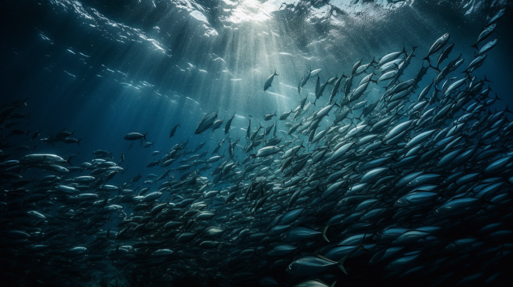
The stretch of water hugging the western shores of North America is a biological powerhouse, teeming with life and considered one of the most fertile marine environments on the planet. The California Current, originating from the colder regions up near British Columbia, sweeps its way down toward Baja California, extending laterally several hundred miles offshore into deep oceanic waters off the continental shelf. The current brings with it not just frigid waters but also a richness of life. As if choreographed, winds usually gust from the land towards the ocean, nudging surface waters away from the coastline. This displacement makes room for deeper, nutrient-packed waters to ascend, in a phenomenon aptly termed upwelling. Coastal upwelling is the dominant physical forcing affecting production in the California Current System.
This blend of icy waters and nutrient wealth sparks a bloom of marine vegetation, ranging from minuscule phytoplankton to sprawling underwater forests of kelp. These plants, often dubbed the “primary producers,” act as the nucleus of an intricate food web. The bounty includes thriving fisheries, generous populations of marine mammals like whales, seals, and dolphins, as well as a multitude of seabirds. The breadth of this fecund ecosystem can span an astonishing distance—up to 300 miles from the shoreline, enveloping a rich diversity of life within its aquatic embrace.
Phytoplankton are a critical part of the ocean’s food web.
The California Current System (CCS) is one of those natural phenomena that don’t often make headlines but quietly shape life as we know it on the West Coast. It’s like the unsung hero of the Pacific, affecting everything from marine biodiversity to our climate, even having a say in whether you’ll need to pack sunscreen or an umbrella for your beach day.
At its core, the California Current is a cold, southward-flowing oceanic current that starts from the Gulf of Alaska and hugs the western coastline of North America. Picture a river within the ocean, except this river is carrying cold, nutrient-rich water from the North Pacific all the way down to the southern tip of Baja California in Mexico. The California Current is part of a broader gyre system that also includes the North Pacific Current, the California Undercurrent, and the Davidson Current. Together, they create a dynamic dance of currents that provide a lifeline to a host of marine species and play a significant role in weather patterns.
The dynamics of the California Current result in abundant wildlife, like these common dolphins, off the coast of California.
The CCS owes its formation to a combination of factors like Earth’s rotation, the prevailing westerly winds, and the shape of the coastline. These elements work in concert to set up a sort of “conveyor belt” for water, funneling it down from higher latitudes. Over millions of years, this system has become a finely tuned natural mechanism that has shaped the ecology and climate of the region in profound ways.
The cold, nutrient-rich waters of the California Current serve as a veritable buffet for marine life. When we talk about nutrients, we’re primarily talking about nitrates and phosphates that act like fertilizer for phytoplankton, the microscopic plants at the base of the marine food web. As phytoplankton bloom, they become a food source for zooplankton, which in turn are gobbled up by larger fish. This cascade effect supports a rich, biodiverse ecosystem that includes everything from sardines and anchovies to humpback whales and even great white sharks. Even seabirds get in on the action, relying on the abundant marine life for nourishment.
The cold, nutrient-rich waters of the California Current serve as a veritable buffet for marine life.
But the California Current doesn’t stop at influencing marine biology; it’s a key player in regional climate as well. For example, the current helps moderate coastal temperatures by funneling cooler air inland. This has a ripple effect on weather patterns and even contributes to the famous “June Gloom” that Angelenos love to lament. Ever wonder why California’s coastal cities have relatively mild, Mediterranean climates while just a short drive inland can bring you much hotter conditions? Tip your hat to the CCS.
Climate change is, of course, the elephant in the room. A study published in the journal “Geophysical Research Letters” in 2019 highlighted a gradual weakening of the California Current due to warming ocean temperatures. As the current weakens, there’s potential for less upwelling, which means fewer nutrients reaching the surface. Less nutrient-rich water could be a gut punch to the marine food web, affecting fish populations and, by extension, the larger predators and human industries that rely on them.
The cold, nutrient-rich waters of the California Current serve as a veritable buffet for marine life.
Another concern is ocean acidification. The same cold, nutrient-rich waters that make the CCS a hotspot for marine life also make it more susceptible to acidification as they absorb more CO2 from the atmosphere. According to a 2020 study in the journal “Nature,” this could have far-reaching consequences for shell-forming organisms like mollusks and some types of plankton, which play crucial roles in the ecosystem.
So why is all of this important? Well, the California Current is a vital cog in the machinery of our planet. It supports rich biodiversity, influences climate, and even has economic implications, given the commercial fisheries that rely on its abundant marine life. A healthy CCS is good news for everyone, from the weekend beachgoer to scientists concerned about biodiversity.
But as we confront a changing climate, the CCS is a poignant reminder that even the most stable and established natural systems are not immune to disruption. Therefore, understanding it is not just an academic exercise, but a necessary step in safeguarding the fragile balance of life along the western edge of North America.
If you’ve ever looked out at the vastness of the ocean, you might think it’s a uniformly barren and flat landscape below the tranquil or tempestuous waves. But you’d be mistaken. Imagine for a moment a hidden world of underwater mountains, volcanoes that never broke the water’s surface, all lying in the mysterious depths of the ocean. These enigmatic formations are known as seamounts, and off the coast of California, they constitute an environment as fascinating as it is vital.
Interestingly, a lot of these seamounts off California are actually relatively new to science. According to Robert Kunzig and his book Mapping the Deep: “In 1984, a sidescan survey off southern California revealed a hundred uncharted seamounts, or undersea volcanoes, in a region that had been thought to be flat.”
The genesis of these structures begins with a geologic process known as plate tectonics. As tectonic plates move beneath the Earth’s crust, they create hotspots of molten rock. This magma escapes through weak points in the crust and solidifies as it reaches the cold seawater, gradually building up into an undersea mountain. After thousands of years, a seamount is born. Most of California’s seamounts are conical in shape, though erosion and other geological forces can turn them into more complex formations over time.
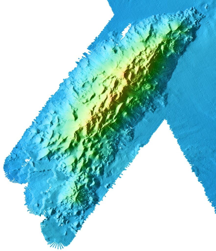
Each seamount is a world unto itself, with distinct mineral compositions, shapes, and ecosystems. Recent research has energized the scientific community. For instance, the Davidson Seamount is the most well-known of these volcanoes and was the first underwater peak to be named a seamount. The seamount is named for George Davidson, a British pioneering scientist and surveyor. Located about 80 km (50 miles) off the coast of Big Sur, it’s shaped like an elongated arrowhead made up of several parallel ridges of sheer volcanic cones. Most of these erupted about 10-15 million years ago, and are made up 320 cubic km of hawaiite, mugearite, and alkalic basalt, the basalt types commonly found along spreading ridges like the Mid-Atlantic Ridge.
Davidson Seamount, Wikipedia
The sheer number of seamounts only began to emerge when new detection methods were developed, including the ability to spot them from space. These underwater mountains are so massive that they create a gravitational pull, drawing seawater slightly toward their center of mass, much like the moon’s pull generates tides. Since seawater is incompressible, it doesn’t compress around the seamounts but instead forms slight bulges on the ocean surface. Satellites can detect these bulges, helping locate the hidden, basaltic peaks below. Satellite studies suggest that the largest seamounts—those over 5,000 feet—may number anywhere from thirty thousand to over one hundred thousand worldwide, with high concentrations in the central Pacific, Indian, and Atlantic Oceans, around Antarctica, and in the Mediterranean. Each of these seamounts is an underwater volcano, typically lining mid-ocean ridges, subduction zones, or one of the forty to fifty oceanic hot spots where the earth’s crust is thin and magma rises from the mantle.
Davidson Seamount is by far the best-studied of the many seamounts off the California coast. Stretching a sprawling 26 miles in length and spanning 8 miles across, this colossal seamount ranks among the largest known formations of its kind in U.S. territorial waters. Towering at a remarkable 7,480 feet from its base to its peak, the mountain remains shrouded in the depths, with its summit situated a substantial 4,101 feet beneath the ocean’s surface. Studies have indicated that some seamounts contain deposits of rare earth elements, which could have potential economic importance in the future.
A rorqual whale fall found near Davidson Seamount at a depth of 3,200 meters. Photo Credit: Chad King / OET, NOAA
Seamounts are biodiversity hotspots. Boasting an incredibly diverse range of deep-sea corals, Davidson Seamount serves as a kind of underwater Eden. Often referred to as “An Oasis in the Deep,” this submerged mountain is a bustling metropolis of marine life, featuring expansive coral forests and sprawling sponge fields. But it doesn’t stop there—crabs, deep-sea fishes, shrimp, basket stars, and a host of rare and still-unidentified bottom-dwelling creatures also call this place home. The seamount is more than just a biologically rich environment; it’s a treasure trove of national importance for its contributions to ocean conservation, scientific research, education, aesthetics, and even history.
Map of seamounts along the California coast. (Marine Conservation Institute)
Perhaps the most astonishing discovery at Davidson Seamount occurred in 2018, when scientists discovered the “Octopus Garden,” the largest known aggregation of octopuses in the world. The garden is about two miles deep and was discovered by researchers on the research vessel (RV) Nautilus. The team of scientists initially spotted a pair of octopuses through a camera on a remotely operated vehicle (ROV). Amanda Kahn, an ecologist at Moss Landing Marine Laboratories and San Jose State University, who was on the Nautilus during the discovery, told Scientific American that after observing the pair for a bit, the operators started to drift away from the rocks to move on, but immediately saw something unusual. “Up ahead of us were streams of 20 or more octopuses nestled in crevices,” Kahn says.
Typically lone wanderers of the ocean, octopuses aren’t known for their social gatherings. So, when researchers stumbled upon more than just one or two of these creatures, they knew something out of the ordinary was afoot. Swiftly pivoting from their original plans, the team zeroed in for a closer look. What they found was a community of these grapefruit-sized, opalescent octopuses, along with something even more mysterious—unusual shimmers in the surrounding water, hinting at the existence of some kind of underwater fluid seeps or springs. It turns out the octopuses migrate to deep-sea hydrothermal springs to breed. The females brood their eggs in the garden, where it is warmer than surrounding waters.
“This Octopus Garden is by far the largest aggregate of octopuses known anywhere in the world, deep-sea or not,” James Barry, a benthic ecologist at the Monterey Bay Aquarium Research Institute told Scientific American. Barry is the leader of the new study, published on in August in Science Advances, that reveals why the animals are gathering. The researchers have observed over 5,700 Pearl octopuses (Muusoctopus robustus) breeding near Davidson Seamount, 3,200 meters below the ocean’s surface. In this deep-sea nursery, octopus mothers keep their eggs warm in 5°C waters flowing from a hydrothermal spring. The water is more than 3°C warmer than the surrounding ocean. This added warmth accelerates the embryos’ development, allowing them to fully mature in just under two years on average.
The Octopuses Garden was studied over the course of 14 dives with MBARI’s remotely operated vehicle (ROV) Doc Ricketts. It is within the Monterey Bay National Marine Sanctuary, so it is federally protected against exploitation and extraction., although many scientists are concerned that global warming could end up having a deleterious impact on the biological life found around seamounts.
So far scientists have discovered other octopus gardens around the globe. There are four deep-sea octopus gardens in total. Two are located off the coast of Central California and two are off the coast of Costa Rica.
New technological advancements like Remotely Operated Vehicles (ROVs) have recently opened doors to discoveries we never thought possible. Cutting-edge imaging technology has finally given us the ability to capture strikingly clear and high-resolution pictures from this enigmatic deep-sea habitat. These vivid images provide both the scientific community and the general public with unprecedented peeks into the lives of rare marine species inhabiting this mostly cold and dark underwater world.
Depth color-coded map of Monterey Canyon. (Monterey Bay Aquarium Research Institute)
Davidson Seamount’s proximity to the rich educational and research ecosystem in the Monterey Bay area. One of the world’s preeminent ocean research organizations, the Monterey Bay Research Institute (MBARI), is located in Moss Landing, California, right at the spot where the magnificent Monterey Canyon stretches away from the coast for hundreds of miles. This geographic boon makes it easier for interdisciplinary teams to join forces, enriching our understanding and educational outreach related to this uniquely captivating undersea landscape.
Beyond being hubs of biodiversity, seamounts also serve as waypoints for migratory species. Just like rest stops along a highway, these underwater mountains provide food and shelter for creatures like whales and tuna on their long journeys. This makes seamounts critical for the health of global marine ecosystems. Additionally, understanding seamounts could give us insights into climate change. They play a role in ocean circulation patterns, which, in turn, affect global weather systems. They are also excellent “archives” of long-term climate data, which could help us understand past climate variations and predict future trends.
Advances in underwater technology, like ROVs, autonomous submersibles and better remote sensing methods, are making it easier to study these mysterious mountains. But many questions still remain unanswered. For instance, how exactly do seamount ecosystems interact with surrounding marine environments? What are the long-term impacts of human activities, like deep-sea mining or overfishing, on these fragile habitats? And what untapped resources, both biological and mineral, lie waiting in these submerged summits?
A time-lapse camera designed by MBARI engineers allowed researchers to observe activity at the Octopus Garden between research expeditions. (Photo: MBARI)
We can wax poetic about the mysteries of seamounts, but understanding them better is crucial for the preservation of marine ecosystems and for equipping ourselves with the knowledge to tackle environmental challenges. So, the next time you look out over the ocean, consider the hidden worlds lying beneath those waves—each a bustling metropolis of life and a potential goldmine of scientific discovery.
Towering over Los Angeles like quiet guardians, the San Gabriel Mountains stretch across the northern edge of the city, keeping watch over the busy sprawl below. More than just a dramatic barrier, these mountains are packed with stories of shifting earth, ancient rock, wild weather, and the people who’ve passed through them for thousands of years. They are also a primary source of Southern California beaches. They’re not just a backdrop; they’re a vital part of the region’s identity, full of science, history, and amazing nature.
Part of the Transverse Ranges, a rare east-west trending group of mountains in California, the San Gabriels rise abruptly from the San Gabriel Valley and form a kind of barrier between L.A. and the Mojave Desert. Framed by Interstate 5 to the west and Interstate 15 to the east, the range is anchored on its north side by the famous San Andreas Fault, where the Pacific and North American tectonic plates constantly grind against each other. That ongoing crush is what helped push these peaks up so quickly. Geologically speaking, they’re growing surprisingly quickly.
Side note: The Transverse Ranges also include the Santa Monica Mountains, San Bernardino Mountains, Santa Ynez Mountains, Topatopa Mountains, Tehachapi Mountains, Santa Susana Mountains, and Sierra Madre Mountains.
Inside the range you’ll find the Angeles and San Bernardino National Forests, along with the San Gabriel Mountains National Monument, first established in 2014 and significantly expanded in 2024 to protect more than 450,000 acres of rugged, biodiverse, and culturally significant terrain. (There is excellent hiking in these mountains.) These protected areas include steep canyons, chaparral, rare wildlife, and sites that are important to the history and traditions of Native American communities.
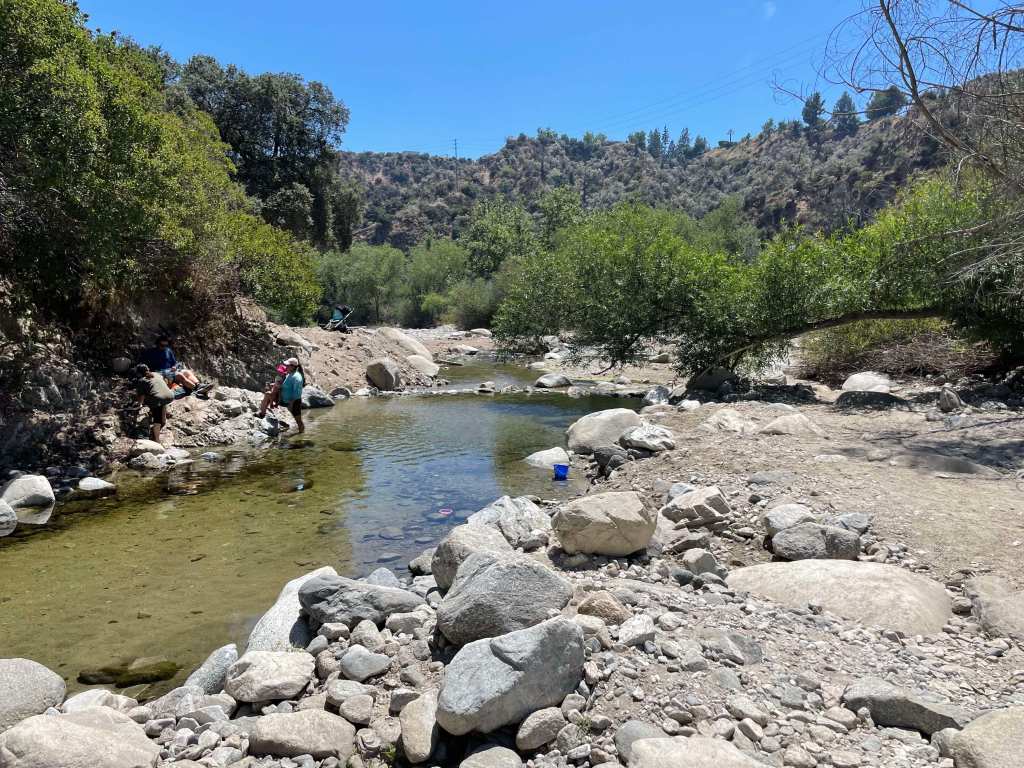
A pool of water from the Arroyo Seco in the San Gabriel Mountain (Erik Olsen)
The rocks here are some of the oldest in the region, but the mountains also tell stories from more recent times: gold miners, early astronomers, hikers, and wildfire researchers. The San Gabriels help shape the weather, store precious snowpack, and remind everyone in L.A. that nature is always nearby and always in motion.
The San Gabriel Mountains offer an impressive rise in elevation, they really kind of explode out of the earth. While the foothills begin at nearly sea level, the highest point in the range is Mount San Antonio, but most people know it as Mount Baldy because, let’s face it, with its distinctive, treeless summit, it looks kind of bald. This peak reaches an altitude of 10,064 feet (3,068 meters). The quick transition from the bustling city to towering peaks is part of the magic of these mountains, a dramatic wall standing guard over downtown Los Angeles.
While the San Gabriels are much smaller in terms of length than, say the Appalachians, they are significantly taller on average. The highest peak in the Appalachians, Mount Mitchell in North Carolina, reaches 6,684 feet (2,037 meters). That’s considerably lower than Mount Baldy in the San Gabriels. The San Gabriels, therefore, boast higher peaks even though they cover a smaller area. However, compared to the Appalachians, which are thought to be billions of years old, the San Gabriel Mountains are relatively young, geologically speaking, and are characterized by rugged and steep features. In essence, being younger, they’ve undergone less erosion.
San Gabriel mountains from La Cañada Flintridge (Photo: Erik Olsen)
To understand the story of the San Gabriel Mountains, we need to embark on a temporal journey spanning millions of years. The mountains’ tale starts about 100 million years ago, during the Mesozoic Era, when massive tectonic plates—the Pacific and North American plates—began to converge. The interaction of these tectonic plates was dramatic, with the Pacific Plate subducting, or diving beneath, the North American Plate. This subduction caused the rocks to melt and, over time, rise to form granitic masses known as plutons.
Rocks of a roadcut in the San Gabriel Mountains (Erik Olsen)
As the ages rolled on, these plutons were uplifted, and the erosion of the surrounding softer rocks exposed the granitic cores, giving birth to the San Gabriel Mountains we see today. The primary rock composition of these mountains is granite, with large-grained crystals of feldspar, quartz, and mica that glitter when the sun kisses their surfaces. These mountains also feature significant deposits of sedimentary rocks, particularly in the lower elevations, which date back to the Mesozoic and Cenozoic eras.
The drainage system of the San Gabriel Mountains is defined by numerous canyons, streams, and arroyos that channel water down from the high elevations into the valleys below. The Arroyo Seco, one of the most well-known waterways, begins near Mount Wilson and flows southwest through Pasadena before merging with the Los Angeles River. Other important streams include the Big Tujunga Creek, which cuts through the mountains to feed into the San Fernando Valley, and the San Gabriel River, which drains much of the range’s eastern side. These waterways are seasonal, swelling during winter rains and spring snowmelt, and often run dry during summer months. Their canyons have been carved by the relentless forces of erosion, creating deep ravines that are vital for wildlife and plant habitats.
Heavy rains cause flooding in the Arroyo Seco near Pasadena. (Erik Olsen)
The San Gabriel Mountains play a critical role in the watershed that serves the greater Los Angeles area. Rain and snowmelt from the mountains replenish groundwater basins and feed into reservoirs, such as the San Gabriel Reservoir and the Morris Reservoir, which are essential for water supply. These mountains act as a natural guidance system, capturing precipitation and funneling it into the region’s aquifers and rivers, supporting both the municipal water supply and flood control efforts. The watershed is crucial for Los Angeles, which depends on these local sources of water to supplement imported supplies from distant regions like the Colorado River and the Owens Valley. The mountain runoff helps maintain the flow of the Los Angeles River, contributing to the city’s efforts to recharge groundwater and ensure a reliable water supply in this semi-arid region.
When it rains it pours, and sometimes causes landslides
Flood control has long been a central concern in managing the water systems of the San Gabriel Mountains, particularly due to the area’s vulnerability to intense, episodic storms. The steep slopes of the mountains funnel rainwater rapidly into urban areas, leading to a heightened risk of flash floods and debris flows. Over time, this led to the construction of a vast network of catchment basins, dams, and debris basins at the foot of the mountains. These basins are designed to capture stormwater runoff, preventing the overflow of water into densely populated areas and managing the sediment and debris that comes with mountain runoff, which can clog waterways and exacerbate flooding.
Catchment basins in the San Gabriel Mountains are critical for controlling debris flows that occur during and after heavy rains, which can be particularly dangerous in areas where wildfires have stripped the landscape of vegetation. When intense rainstorms hit the steep, fire-scarred slopes, they trigger massive torrents of mud, boulders, and tree debris that rush down the mountain canyons toward the urban foothills. These debris flows can overwhelm creeks and spill into residential neighborhoods, causing widespread destruction. The catchment basins are designed to trap this debris before it reaches populated areas, but their effectiveness depends on regular maintenance and clearing. When these basins fill up too quickly or are not properly maintained, debris can overtop them, leading to significant flooding and property damage.
default
A stark example of the dangers posed by debris flows occurred in Montrose in 1934. Following a series of intense storms in the aftermath of the New Year’s Day floods, massive debris flows roared out of the San Gabriel Mountains, devastating the communities of Montrose, La Crescenta, and Tujunga. The floods and debris flows buried homes and roads under several feet of mud and debris, killing at least 45 people. The Montrose landslide became a tragic reminder of the risks associated with living near the San Gabriel Mountains, particularly in the face of severe weather. This event spurred greater investments in flood control infrastructure, including the construction of more robust debris basins to mitigate the effects of future storms.
The San Gabriel Mountains aren’t just a spectacle of natural processes; they’ve also been a silent witness to numerous significant historical events. The grave of Owen Brown can be found in the mountains just outside of La Canada Flintridge. Owen was the third son of abolitionist John Brown, and has a resting place that has stirred intrigue and speculation for generations. Owen’s grave has become a kind of pilgrimage site for those interested in American history.
Locals gather to celebrate the installation of a gravestone honoring abolitionist Owen Brown on January 29, 1898, nearly a decade after his death. Photo: Brown family and Paul Ayers.
Owen Brown was a fervent abolitionist like his father and participated in the famous raid on Harpers Ferry. After the tumultuous events that marked his early life, he moved to California, seeking solace in the west. He settled near El Prieto Canyon and lived a relatively secluded life. After his death in 1889, he was buried on a hillside overlooking the canyon, and his grave was marked with a simple headstone. Over time, nature, vandals, and other factors led to the original headstone’s disappearance, adding a layer of mystique to the grave’s location. However, in 2019, a replica of the gravestone was installed.
Mount Wilson is another historical wonder in the range. Standing at a towering height of 5,710 feet, it’s not just its elevation that sets Mt. Wilson apart. In the early 20th century, the Mount Wilson Observatory was established, and it soon became a hub of astronomical discoveries. It was here that Edwin Hubble, using the Hooker Telescope, provided evidence of the expansion of the universe—a groundbreaking observation that eventually led to the Big Bang Theory.
Infrastructure Marvel: The Angeles Crest Highway The human connection to the San Gabriel Mountains was further cemented with the construction of the Angeles Crest Highway in the 1930s. Spanning approximately 66 miles, this scenic byway was a colossal engineering challenge. Its creation provided access to previously remote regions and breathtaking panoramic views that today lure thousands of tourists and nature enthusiasts. The highway is also one of the highest in Southern California, with a summit of 7,903 feet at the Dawson Saddle.
Angeles Crest Highway roadcut (Photo: Erik Olsen)
Driving on the Angeles Crest Highway is an experience that’s both thrilling and a bit nerve-wracking. Winding and twisting through the mountains, you can come across steep drop-offs, sharp turns, and narrow lanes. With elevation changes ranging from around 1,200 feet to more than 7,900 feet, it’s a route that demands respect and attention from those behind the wheel.
Flora, Fauna, and Natural History: A Biodiversity Hotspot Beyond geology and history, the San Gabriel Mountains are a treasure trove of biodiversity. The montane environment, with its varied elevation and climate zones, has given rise to a rich tapestry of flora and fauna. Iconic trees like the Jeffrey pine, Coulter pine, and California black oak adorn the landscape. Wildflowers paint the meadows in vibrant hues, from the golden yarrow to the scarlet larkspur.
The fauna is just as diverse, with animals like the California condor, bighorn sheep, and mountain lions roaming the rugged terrain. The waters that trickle and rush down these mountains are home to arroyo chubs and Santa Ana suckers.
The California condor is known to inhabit the San Gabriel range
Protection of this vital ecosystem came in the form of the San Gabriel Mountains National Monument designation in 2014, ensuring that the mountains’ rich biodiversity and cultural significance will be preserved for generations.
The San Gabriel Mountains are more than just a scenic backdrop. They reflect the Earth’s active geology, hold key historical moments, and support diverse ecosystems. Amid growing urbanization, these mountains remain a lasting reminder of the interconnectedness of life, history, and natural forces.
Underwater photos of California’s coast featured in books and magazines almost always showcase a certain fish: the garibaldi. Within the underwater kaleidoscope of California’s coastal waters, the Garibaldi fish stands out with its fiery orange hue. The garibaldi, a member of the damselfish family, is the California State marine fish, and its possession is illegal.
The fish is likely named after the 19th-century Italian revolutionary Giuseppe Garibaldi, whose army wore bright red shirts, or after the “garibaldi”, a woman’s red blouse worn in the 1890’s.
Biologically speaking, the Garibaldi fish owe their orange coloring mainly to pigments called carotenoids. These carotenoids are pretty interesting; you’ll find them in many fruits and vegetables, like carrots, for example, where they give off that familiar orange glow. Garibaldi eat a diet rich in crustaceans, such as crabs and shrimps, which are packed with these pigments. When the fish ingest them, the carotenoids are absorbed and deposited into the skin tissues.
Carotenoids can also act as antioxidants, which means they might even play a role in protecting the fish’s cells from damage. This is a bit of a two-for-one deal: not only do they get to look good, but they also get some potential health benefits as well.
Interestingly, there’s a bit of a territorial aspect to the bright orange coloration. Garibaldi fish are known to be quite territorial, and the males are especially flashy. They use their bright coloration to ward off rivals and also to attract mates.
California Garibaldi
The color isn’t just a superficial beauty mark; it plays a significant role in the fish’s survival and reproductive strategies. The orange hue signals strength, dominance, and overall fitness. It’s like a badge of honor they wear to proclaim, “Look at me, I’m strong, healthy, and in charge here!”
The Garibaldi is more than just a pretty face in the crowd. This fish, found from Monterey Bay down to Baja California, displays behaviors and characteristics that make it a subject of intrigue for marine biologists and diving enthusiasts alike.
One of the best places to see Garibaldi if you are a diver or enjoy snorkeling is off the coast of Catalina Island, about 20 miles from Long Beach. One particularly popular spot is Casino Point in the city of Avalon on the island.
Known for being highly territorial, the male Garibaldi is an underwater homeowner, meticulously crafting nests from red algae during mating season. This homemaking process is not just about building; it’s about showmanship. The males showcase their algae-laden nests to prospective females in an underwater dance, swimming around their creation with pride, hoping to entice the females to lay their eggs there.
A California Garibaldi protecting its nest.
But the courtship doesn’t end with the dance. Once the female is wooed and the eggs are laid, the male Garibaldi takes on the role of a nurturing parent. He stands guard over the eggs, fanning them with his pectoral fins to ensure they are well-oxygenated. He even goes to the extent of confronting divers or other fish that venture too close to his precious brood.
The Garibaldi’s territorial nature also extends to a curious interaction with humans. Despite their fierceness in protecting their domain, these fish are known to approach divers, examining them with an inquisitive gaze. This friendliness, coupled with their radiant color, makes them a favorite subject among underwater photographers.
“The only thing that seems to affect their fearless behavior is the color of the animal that’s approaching them,” said Cabrillo Marine Aquarium (CMA) Research Curator Dr. Kiersten Darrow. “They will attack everybody else, but if they see that it’s a garibaldi fish of a certain type then they will back away.”
Female California Garibaldi
Perhaps even more fascinating is the Garibaldi’s voice – a distinctive thumping sound that some divers have reported hearing. Though the exact reason for this sound is not entirely understood, it’s believed to be related to their territorial behavior, adding another layer to the mystique of this remarkable fish.
Beyond its engaging behaviors, the Garibaldi’s story carries a note of triumph in conservation. Its popularity led to overfishing in the past, which spurred protective measures. Today, the Garibaldi enjoys protected status in California waters, safeguarding it from harm and allowing it to thrive.
A testament to resilience, the Garibaldi can live for over 20 years, growing slowly and reaching full maturity at about six years of age. This longevity, coupled with its unique characteristics, makes it a symbol of the diverse and vibrant marine life that graces California’s coastline.
Catalina Island and Casino Point (Erik Olsen)
In the world of marine biology, where hidden wonders often lie beneath the waves, the Garibaldi emerges as a charismatic star. With its bold color, intricate courtship rituals, protective parenting, and friendly curiosity, it captures the imagination, not just as a beautiful spectacle but as a complex character in the grand tapestry of ocean life. Whether seen during a dive or behind the glass of an aquarium, the Garibaldi remains a fascinating glimpse into the rich and often surprising world beneath the sea.


