

Geologist Thomas Dibblee Jr. and the Theory Behind Pinnacles National Park’s 200-Mile Tectonic Journey
Pinnacles National Park’s wide landscape of dramatic rock formations and craggy spires looks otherworldly, especially in golden hour light. But few people who visit the park, located in Central California, southeast of the San Francisco Bay Area, are aware that the rock formations were once at the center of one of the most fierce debates in the history of California geology.
“Altogether, this one man mapped almost one-fourth of California, or about 100,000 square kilometers, 40,000 square miles, more land than any human has ever mapped or ever will map.” California geologist and author Donald Prothero on Thomas Dibblee Jr.
Pretty much everyone in California has heard of the San Andreas Fault, that long, slashing seam in the earth that marks the divide between the Pacific and North American tectonic plates. It’s a source of anxiety, cheesy films, and endless earthquake predictions. But what most people don’t realize is just how fast it’s moving. In geological terms, the fault is racing, shifting at a rate of about two inches per year. That may not sound like much, but over millions of years, it’s enough to dramatically reshape the landscape. And it’s this constant motion that obsessed one of California’s most prolific and underappreciated geologists: Thomas Dibblee Jr.
His story takes us to one of the lesser-known national parks in the state:
Pinnacles National Park’s open landscape of dramatic rock formations and craggy spires looks otherworldly, especially in golden hour light. But few people who visit the park, located in Central California, southeast of the San Francisco Bay Area, are aware that the rock formations were once at the center of a fierce debate in the history of California geology.
And at the center of the controversy was Dibblee.
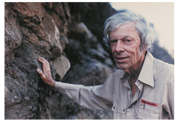 Thomas Dibblee Jr. (Source: Wikipedia)
Pinnacles National Park, formerly Pinnacles National Monument, is, at its core, a story about the geologic forces of the San Andreas Fault. The fault is the conveyor belt for the dramatic northward journey of the park’s volcanic remnants. Dibblee’s research illuminated how, over millions of years, the landscapes we see today were sculpted by the movements of these tectonic plates and how the shape of California as a state has changed dramatically as a result.
The crux of Dibblee’s discovery lies in the relationship between Pinnacles National Park and a volcanic source located near present-day Neenach, close to Palmdale in Southern California. The geological narrative that Dibblee (along with geologist Mason L. Hill) pieced together revealed that the rock formations at Pinnacles originated from the same volcanic eruptions that occurred approximately 23 million years ago, near what is now Neenach. In other words, during his mapping, Dibley had discovered that there were rock units on one side of the San Andreas Fault that clearly matched with others on the opposite side, but they’d moved apart, splitting these formations by over 195 miles (314 kilometers) to their current location. In fact, if you could restore the block of California west of the San Andreas Fault to where it sat during the Jurassic, about 150 to 200 million years ago, you’d find it began far south of today’s Mexican border.

Purchase stunning coffee mugs and art prints of iconic California scenes.
**Check out our Etsy store. **
At the time, very few people, geologists included, believed that was possible. Dibblee had to be wrong. But it turned out, he was not, and his measurements and discovery launched a passionate debate about the speed of geologic forces. In the years after 1953, more and more matching formations were discovered, confirming Dibblee’s bold idea.
Remember that the San Andreas Fault is a strike-slip fault. That means instead of the Pacific and North American Plates crashing into each other and forming mountains or one diving beneath the other, they slide past each other horizontally: imagine placing your hands side by side and rubbing them in opposite directions.
 Pinnacles National Park (NPS)
By correlating the age and type of rocks across this fault line, Dibblee inferred that the only plausible explanation for the similarity between the rocks at Pinnacles and those near Neenach was that they had once been part of the same volcanic field, which had been split and displaced over millions of years due to the movement of the San Andreas Fault.
Dibblee’s findings not only shed light on the significant distances that landscapes can travel over geological timeframes but also provided a tangible connection between the theory of plate tectonics and observable geological features. The movement he documented showed that the San Andreas Fault has played a critical role in shaping not just California’s geology, but also its identity.
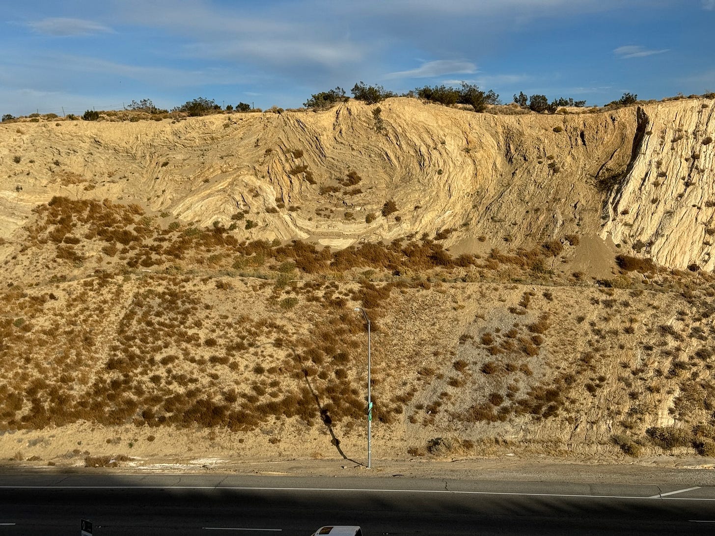 The Palmdale roadcut, just off Highway 14, sits directly on the San Andreas Fault, and its twisted layers of rock reveal the dramatic tectonic forces that have shaped the region over thousands of years. (Photo: Erik Olsen)
Dibblee’s work also benefited from the broader scientific context of his time, particularly the emerging theory of plate tectonics in the mid-20th century. This theoretical framework provided a mechanism for understanding how large-scale movements of the Earth’s crust could result in the displacement of geological formations over vast distances.
As we noted in a recent story about the scarcity of dinosaur fossils in the state, much of California is made up of former ocean floor that has been scraped, uplifted, and reshaped over time. That intense tectonic activity has destroyed, buried, or recycled many fossils, helping explain why dinosaur remains are so rare here.
As discussed, Dibblee’s ideas were controversial at the time. Many in the scientific community were hesitant to embrace a theory that suggested such dramatic movement across the Earth’s crust, partly because it challenged existing theories and partly due to the limitations of the geological evidence available at the time. The prevailing theories favored more static models of the Earth’s crust, with changes occurring slowly over immense periods, a process known as uniformitarianism.
 San Andreas Fault looking northwest onto the Carrizo Plain (John Wiley)
In the mid-20th century, uniformitarianism was still the prevailing framework in geology. Most geologists believed in slow, vertical movements of the Earth’s crust like uplift and subsidence as the primary drivers of landscape change. While horizontal motion was not entirely dismissed, the idea that entire blocks of rock could move hundreds of miles sideways along a fault like the San Andreas was considered radical.
But what about the man himself?
Born in 1911 in Santa Barbara, Dibblee grew up surrounded by California’s rugged landscapes. His interest in geology started early, shaped by both curiosity and the rich terrain around him.
After earning his degree from Stanford in 1936, Dibblee embarked on his professional journey with Union Oil, later moving to Richfield, which became ARCO. It was during this period that his extensive field mapping efforts culminated in the discovery of the Russell Ranch oil field near New Cuyama, near Santa Barbara. By 1952, Dibblee had meticulously mapped every sedimentary basin in California with potential for oil, cementing his status as a prolific and brilliant petroleum geologist.

Dibblee moved on to a career at the United States Geological Survey (USGS) that would span over six decades, much of it spent with the agency and then later through independent projects. According to California geologist and author Donald Prothero, in his excellent book The Story of the Earth in 25 Rocks: Tales of Important Geological Puzzles and the People Who Solved Them, Dibblee’s stamina was extraordinary. Even into his 70s and 80s, he could outwalk much younger geologists. He often worked alone in remote parts of California, methodically mapping the landscape. Over his lifetime, he mapped nearly a quarter of the state, roughly 40,000 square miles, more than any individual geologist has ever mapped. In 1983, he received a Presidential Volunteer Action Award from President Reagan.
His maps are celebrated for their accuracy and detail, serving as critical tools for academic research, oil exploration, environmental planning, and education. The Dibblee Geological Foundation was established to honor his work, and now his maps are available through the Santa Barbara Museum of Natural History.
 A Dibblee Map (Santa Barbara Museum of Natural History)
Thomas Dibblee Jr. died in 2004 at his Santa Barbara home at the age of 93. His contributions to the field of geology are not just confined to his maps and scientific discoveries. He was also a mentor and inspiration to many aspiring geologists, sharing his knowledge and passion for the Earth’s history through lectures, field trips, and personal guidance. His dedication to his work and his ability to convey complex geological concepts in an accessible manner made him a respected figure among his peers and students alike. He’s still considered a legend among geologists. Through his dedication and pioneering work, Dibblee has left an indelible mark on the field of geology, making him a true giant in the scientific exploration of California as well as our planet.
More California science, photography and wild places on Instagram @californiacuratedus