The Ocean’s Invisible Elevator: How Upwelling Fuels California’s Marine Bounty

The Vital Role of Upwelling in California’s Rich Ocean Life

Few marine processes have been as impactful on the abundance of sea life off the coast of California as upwelling. It may not be a term you’ve heard before, but the natural oceanic process of upwelling is one of the most important engines driving climate, biological diversity, and the ocean’s food web. It’s time to pay attention.

In simple terms, upwelling happens when deep, cold, nutrient-laden water moves toward the ocean surface, replacing the warm surface water. Along the California coast, it’s fueled by the California Current, which flows southward, and by prevailing northerly winds. The wind pushes surface water offshore, allowing the deeper water to well up and take its place. This isn’t just an abstract idea; it’s been studied extensively.

In California, upwelling occurs year-round off the northern and central coast. It’s strongest in the spring and summer when northwesterly winds are at their most powerful. Upwelling is reduced in the fall and winter when winds are more variable.

Killer whales benefit from upwelling because the nutrient-rich waters fuel a surge in phytoplankton, which triggers an increase in the populations of smaller prey fish and marine mammals that orcas rely on for sustenance. (Photo: NOAA)

Researchers from institutions like the Scripps Institution of Oceanography and Stanford University have used a variety of methods, including satellite observations and computer modeling, to study upwelling. One of the groundbreaking studies was the CalCOFI program (California Cooperative Oceanic Fisheries Investigations), which began in the late 1940s. It was a joint venture between Scripps and state and federal agencies to investigate the collapse of the sardine fishery. Over decades, it has expanded its scope and now provides invaluable long-term datasets that help scientists understand the dynamics of upwelling and its effects on marine populations.

CALIFORNIA CURATED ART ON ETSY

Purchase stunning art prints of iconic California scenes.
Check out our Etsy store.

The key to understanding the phenomenon of upwelling off the California coast begins with the importance of cold water. In colder regions, nutrients from the deeper layers of the ocean are more readily brought to the surface through various oceanic processes like upwelling, tidal action, and seasonal mixing.

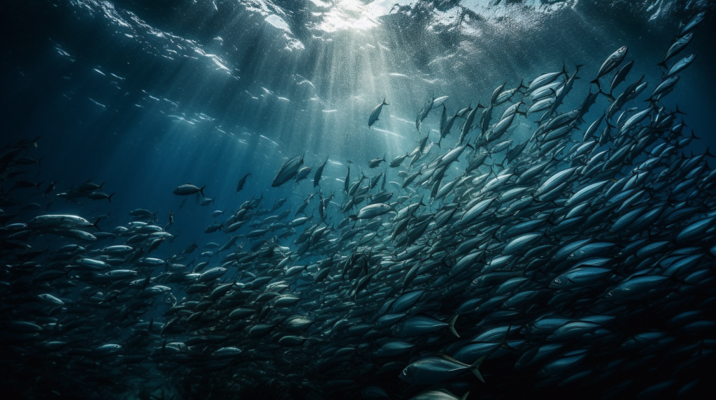
Think of a well-fertilized garden versus a nutrient-poor one. In the former, you’d expect a lush array of plants that not only thrive, but also support a diversity of insect and animal life. Similarly, the nutrient-rich cold waters support “blooms” of phytoplankton, a critical component of the oceanic food web. Phytoplankton are microscopic, photosynthetic organisms that form the foundation of aquatic food webs, producing oxygen and serving as a primary food source for marine life. When these primary producers flourish, it sets off a chain reaction throughout the ecosystem. Zooplankton (tiny ocean-borne animals like krill) feast on phytoplankton, small fish feast on zooplankton, and larger predators, including larger fish, marine mammals, and seabirds, find an abundant food supply in these teeming waters.

Moreover, cold water has a higher capacity to hold dissolved gases like oxygen compared to warm water (one of the reasons that warming seas could be a problem in the future). Oxygen is a key factor for respiration in marine animals. In cold, oxygen-rich environments, organisms can efficiently carry out metabolic processes, which often results in higher rates of feeding, growth, and reproduction, thereby further boosting biological productivity.

A recent study has also shed light on how California’s rich marine ecosystem responds to climate patterns, particularly the El Niño and La Niña phases of the El Niño/Southern Oscillation (ENSO). Scientists found that during El Niño events, warmer waters and weaker upwelling lead to reduced nutrient levels in the California Current, which supports less phytoplankton and affects the entire food web, including fish populations. In contrast, La Niña conditions boost upwelling, bringing nutrient-rich waters to the surface and enhancing marine productivity. This research highlights the far-reaching impacts of climate cycles on ocean life and could help in forecasting changes that affect fisheries and marine biodiversity in California.

Sardines off the coast of California (Photo: NOAA)

Studies have also shown the direct correlation between the intensity of upwelling and the success of fish populations. A study published in the journal “Science Advances” in 2019 explored how variations in upwelling affect the foraging behavior and success of California sea lions. Researchers found that in years with strong upwelling, sea lions didn’t have to travel as far to find food, which, in turn, positively impacted their population’s health.

Upwelling is a critical oceanic process that helps maintain the stable and immensely productive California marine ecosystem, but there are serious concerns that the dynamics behind upwelling could be changing due to climate change.

Of course, upwelling isn’t just a California thing; it’s a global phenomenon that occurs in various parts of the world, from the coasts of Peru to the Canary Islands. But California is like the poster child, thanks to extensive research and its vital role in a multi-billion dollar fishing industry that includes coveted species like albacore tuna, swordfish, Dungeness crab, squid, and sardines.

Inspiration Point Channel Islands (Photo: NPS)

The Channel Islands provide an excellent example of a place off the California coast where the impacts of upwelling and ocean currents are particularly significant. Channel Islands National Park is uniquely located in a “transition zone” of less than 100 km where many ocean currents converge. This results in strikingly different ocean conditions at individual islands and affects where different species are found and how abundant they are.

Long-term studies of upwelling and the California Current system have shed further light on the importance of these complex and ever changing phenomenon. For example, the annual California Current Ecosystem Status Report captures the big picture of the biology, climate, physical, and social conditions of the marine ecosystem. In 2021, the California Current continued a recent cooling trend, with researchers recording the coldest conditions on the continental shelf in nearly a decade. These cooler coastal waters resulted from strong wind-driven upwelling—nutrient-rich, deep ocean water coming to the surface.

Sea surface temperature anomalies across the northeastern Pacific in August, 2019. A marine heat wave spread across the northeastern Pacific Ocean from 2014 to 2016 and the expanse of warm surface water returned to the region in 2019. (NASA Earth Observatory)

But things have grown more precarious in the north and out to sea. For the last ten years, the northeast Pacific Ocean has been a hotspot for marine heatwaves. Just this past year, scientists monitored the seventh most intense marine heatwave in this region since records began in 1982. However, there was a twist in the tale: unlike in previous years, the elevated water temperatures remained further offshore, a phenomenon partly attributable to stronger-than-average coastal upwelling. As a result, the strip of waters closer to the coast was able to maintain its cooler temperatures, thereby preserving a productive environment for marine life.

Visit the California Curated store on Etsy for original prints showing the beauty and natural wonder of California.

Upwelling is a critical oceanic process that helps maintain the stable and immensely productive California marine ecosystem, but there are serious concerns that the dynamics behind upwelling could be changing due to climate change. Warming ocean temperatures and changes in wind patterns could potentially disrupt the timing and intensity of upwelling, putting the bounty of California’s coast at risk.

Understanding these shifts is imperative for devising strategies to mitigate adverse effects on marine life and commercial fisheries. Therefore, sustained research efforts must continue to dissect this complex (and incredibly important) oceanic process and its increasingly uncertain future.

Navigating the Unseen Current: How the California Current System Shapes Our Ocean, Climate, and Future

The stretch of water hugging the western shores of North America is a biological powerhouse, teeming with life and considered one of the most fertile marine environments on the planet. The California Current, originating from the colder regions up near British Columbia, sweeps its way down toward Baja California, extending laterally several hundred miles offshore into deep oceanic waters off the continental shelf. The current brings with it not just frigid waters but also a richness of life. As if choreographed, winds usually gust from the land towards the ocean, nudging surface waters away from the coastline. This displacement makes room for deeper, nutrient-packed waters to ascend, in a phenomenon aptly termed upwelling. Coastal upwelling is the dominant physical forcing affecting production in the California Current System.

This blend of icy waters and nutrient wealth sparks a bloom of marine vegetation, ranging from minuscule phytoplankton to sprawling underwater forests of kelp. These plants, often dubbed the “primary producers,” act as the nucleus of an intricate food web. The bounty includes thriving fisheries, generous populations of marine mammals like whales, seals, and dolphins, as well as a multitude of seabirds. The breadth of this fecund ecosystem can span an astonishing distance—up to 300 miles from the shoreline, enveloping a rich diversity of life within its aquatic embrace.

Phytoplankton are a critical part of the ocean’s food web.

The California Current System (CCS) is one of those natural phenomena that don’t often make headlines but quietly shape life as we know it on the West Coast. It’s like the unsung hero of the Pacific, affecting everything from marine biodiversity to our climate, even having a say in whether you’ll need to pack sunscreen or an umbrella for your beach day.

At its core, the California Current is a cold, southward-flowing oceanic current that starts from the Gulf of Alaska and hugs the western coastline of North America. Picture a river within the ocean, except this river is carrying cold, nutrient-rich water from the North Pacific all the way down to the southern tip of Baja California in Mexico. The California Current is part of a broader gyre system that also includes the North Pacific Current, the California Undercurrent, and the Davidson Current. Together, they create a dynamic dance of currents that provide a lifeline to a host of marine species and play a significant role in weather patterns.

The dynamics of the California Current result in abundant wildlife, like these common dolphins, off the coast of California.

The CCS owes its formation to a combination of factors like Earth’s rotation, the prevailing westerly winds, and the shape of the coastline. These elements work in concert to set up a sort of “conveyor belt” for water, funneling it down from higher latitudes. Over millions of years, this system has become a finely tuned natural mechanism that has shaped the ecology and climate of the region in profound ways.

The cold, nutrient-rich waters of the California Current serve as a veritable buffet for marine life. When we talk about nutrients, we’re primarily talking about nitrates and phosphates that act like fertilizer for phytoplankton, the microscopic plants at the base of the marine food web. As phytoplankton bloom, they become a food source for zooplankton, which in turn are gobbled up by larger fish. This cascade effect supports a rich, biodiverse ecosystem that includes everything from sardines and anchovies to humpback whales and even great white sharks. Even seabirds get in on the action, relying on the abundant marine life for nourishment.

The cold, nutrient-rich waters of the California Current serve as a veritable buffet for marine life.

But the California Current doesn’t stop at influencing marine biology; it’s a key player in regional climate as well. For example, the current helps moderate coastal temperatures by funneling cooler air inland. This has a ripple effect on weather patterns and even contributes to the famous “June Gloom” that Angelenos love to lament. Ever wonder why California’s coastal cities have relatively mild, Mediterranean climates while just a short drive inland can bring you much hotter conditions? Tip your hat to the CCS.

CALIFORNIA CURATED ON ETSY

Purchase stunning coffee mugs and art prints of Californian icons.
Check out our Etsy store.

Climate change is, of course, the elephant in the room. A study published in the journal “Geophysical Research Letters” in 2019 highlighted a gradual weakening of the California Current due to warming ocean temperatures. As the current weakens, there’s potential for less upwelling, which means fewer nutrients reaching the surface. Less nutrient-rich water could be a gut punch to the marine food web, affecting fish populations and, by extension, the larger predators and human industries that rely on them.

The cold, nutrient-rich waters of the California Current serve as a veritable buffet for marine life.

Another concern is ocean acidification. The same cold, nutrient-rich waters that make the CCS a hotspot for marine life also make it more susceptible to acidification as they absorb more CO2 from the atmosphere. According to a 2020 study in the journal “Nature,” this could have far-reaching consequences for shell-forming organisms like mollusks and some types of plankton, which play crucial roles in the ecosystem.

So why is all of this important? Well, the California Current is a vital cog in the machinery of our planet. It supports rich biodiversity, influences climate, and even has economic implications, given the commercial fisheries that rely on its abundant marine life. A healthy CCS is good news for everyone, from the weekend beachgoer to scientists concerned about biodiversity.

But as we confront a changing climate, the CCS is a poignant reminder that even the most stable and established natural systems are not immune to disruption. Therefore, understanding it is not just an academic exercise, but a necessary step in safeguarding the fragile balance of life along the western edge of North America.

Davidson Seamount and the Unseen Mountains and Hidden Treasures Off California’s Coast

California’s coast is home to dozens of seamounts, each harboring diverse ecosystems and geological mysteries waiting to be explored.

The Octopuses Garden on Davidson Seamount in California. Photo Credit: Chad King / OET, NOAA

If you’ve ever looked out at the vastness of the ocean, you might think it’s a uniformly barren and flat landscape below the tranquil or tempestuous waves. But you’d be mistaken. Imagine for a moment a hidden world of underwater mountains, volcanoes that never broke the water’s surface, all lying in the mysterious depths of the ocean. These enigmatic formations are known as seamounts, and off the coast of California, they constitute an environment as fascinating as it is vital. 

Interestingly, a lot of these seamounts off California are actually relatively new to science. According to Robert Kunzig and his book Mapping the Deep: “In 1984, a sidescan survey off southern California revealed a hundred uncharted seamounts, or undersea volcanoes, in a region that had been thought to be flat.”

The genesis of these structures begins with a geologic process known as plate tectonics. As tectonic plates move beneath the Earth’s crust, they create hotspots of molten rock. This magma escapes through weak points in the crust and solidifies as it reaches the cold seawater, gradually building up into an undersea mountain. After thousands of years, a seamount is born. Most of California’s seamounts are conical in shape, though erosion and other geological forces can turn them into more complex formations over time. 

Each seamount is a world unto itself, with distinct mineral compositions, shapes, and ecosystems. Recent research has energized the scientific community. For instance, the Davidson Seamount is the most well-known of these volcanoes and was the first underwater peak to be named a seamount. The seamount is named for George Davidson, a British pioneering scientist and surveyor. Located about 80 km (50 miles) off the coast of Big Sur, it’s shaped like an elongated arrowhead made up of several parallel ridges of sheer volcanic cones. Most of these erupted about 10-15 million years ago, and are made up 320 cubic km of hawaiite, mugearite, and alkalic basalt, the basalt types commonly found along spreading ridges like the Mid-Atlantic Ridge. 

Davidson Seamount, Wikipedia

The sheer number of seamounts only began to emerge when new detection methods were developed, including the ability to spot them from space. These underwater mountains are so massive that they create a gravitational pull, drawing seawater slightly toward their center of mass, much like the moon’s pull generates tides. Since seawater is incompressible, it doesn’t compress around the seamounts but instead forms slight bulges on the ocean surface. Satellites can detect these bulges, helping locate the hidden, basaltic peaks below. Satellite studies suggest that the largest seamounts—those over 5,000 feet—may number anywhere from thirty thousand to over one hundred thousand worldwide, with high concentrations in the central Pacific, Indian, and Atlantic Oceans, around Antarctica, and in the Mediterranean. Each of these seamounts is an underwater volcano, typically lining mid-ocean ridges, subduction zones, or one of the forty to fifty oceanic hot spots where the earth’s crust is thin and magma rises from the mantle.

Davidson Seamount is by far the best-studied of the many seamounts off the California coast. Stretching a sprawling 26 miles in length and spanning 8 miles across, this colossal seamount ranks among the largest known formations of its kind in U.S. territorial waters. Towering at a remarkable 7,480 feet from its base to its peak, the mountain remains shrouded in the depths, with its summit situated a substantial 4,101 feet beneath the ocean’s surface. Studies have indicated that some seamounts contain deposits of rare earth elements, which could have potential economic importance in the future. 

A rorqual whale fall found near Davidson Seamount at a depth of 3,200 meters. Photo Credit: Chad King / OET, NOAA

Seamounts are biodiversity hotspots. Boasting an incredibly diverse range of deep-sea corals, Davidson Seamount serves as a kind of underwater Eden. Often referred to as “An Oasis in the Deep,” this submerged mountain is a bustling metropolis of marine life, featuring expansive coral forests and sprawling sponge fields. But it doesn’t stop there—crabs, deep-sea fishes, shrimp, basket stars, and a host of rare and still-unidentified bottom-dwelling creatures also call this place home. The seamount is more than just a biologically rich environment; it’s a treasure trove of national importance for its contributions to ocean conservation, scientific research, education, aesthetics, and even history.

Map of seamounts along the California coast. (Marine Conservation Institute)

Perhaps the most astonishing discovery at Davidson Seamount occurred in 2018, when scientists discovered the “Octopus Garden,” the largest known aggregation of octopuses in the world. The garden is about two miles deep and was discovered by researchers on the research vessel (RV) Nautilus. The team of scientists initially spotted a pair of octopuses through a camera on a remotely operated vehicle (ROV). Amanda Kahn, an ecologist at Moss Landing Marine Laboratories and San Jose State University, who was on the Nautilus during the discovery, told Scientific American that after observing the pair for a bit, the operators started to drift away from the rocks to move on, but immediately saw something unusual. “Up ahead of us were streams of 20 or more octopuses nestled in crevices,” Kahn says.

Typically lone wanderers of the ocean, octopuses aren’t known for their social gatherings. So, when researchers stumbled upon more than just one or two of these creatures, they knew something out of the ordinary was afoot. Swiftly pivoting from their original plans, the team zeroed in for a closer look. What they found was a community of these grapefruit-sized, opalescent octopuses, along with something even more mysterious—unusual shimmers in the surrounding water, hinting at the existence of some kind of underwater fluid seeps or springs. It turns out the octopuses migrate to deep-sea hydrothermal springs to breed. The females brood their eggs in the garden, where it is warmer than surrounding waters.

“This Octopus Garden is by far the largest aggregate of octopuses known anywhere in the world, deep-sea or not,” James Barry, a benthic ecologist at the Monterey Bay Aquarium Research Institute told Scientific American. Barry is the leader of the new study, published on in August in Science Advances, that reveals why the animals are gathering.  The researchers have observed over 5,700 Pearl octopuses (Muusoctopus robustus) breeding near Davidson Seamount, 3,200 meters below the ocean’s surface. In this deep-sea nursery, octopus mothers keep their eggs warm in 5°C waters flowing from a hydrothermal spring. The water is more than 3°C warmer than the surrounding ocean. This added warmth accelerates the embryos’ development, allowing them to fully mature in just under two years on average.

The Octopuses Garden was studied over the course of 14 dives with MBARI’s remotely operated vehicle (ROV) Doc Ricketts. It is within the Monterey Bay National Marine Sanctuary, so it is federally protected against exploitation and extraction., although many scientists are concerned that global warming could end up having a deleterious impact on the biological life found around seamounts.

So far scientists have discovered other octopus gardens around the globe. There are four deep-sea octopus gardens in total. Two are located off the coast of Central California and two are off the coast of Costa Rica.

New technological advancements like Remotely Operated Vehicles (ROVs) have recently opened doors to discoveries we never thought possible. Cutting-edge imaging technology has finally given us the ability to capture strikingly clear and high-resolution pictures from this enigmatic deep-sea habitat. These vivid images provide both the scientific community and the general public with unprecedented peeks into the lives of rare marine species inhabiting this mostly cold and dark underwater world.

Depth color-coded map of Monterey Canyon. (Monterey Bay Aquarium Research Institute)

Davidson Seamount’s proximity to the rich educational and research ecosystem in the Monterey Bay area. One of the world’s preeminent ocean research organizations, the Monterey Bay Research Institute (MBARI), is located in Moss Landing, California, right at the spot where the magnificent Monterey Canyon stretches away from the coast for hundreds of miles. This geographic boon makes it easier for interdisciplinary teams to join forces, enriching our understanding and educational outreach related to this uniquely captivating undersea landscape.

Beyond being hubs of biodiversity, seamounts also serve as waypoints for migratory species. Just like rest stops along a highway, these underwater mountains provide food and shelter for creatures like whales and tuna on their long journeys. This makes seamounts critical for the health of global marine ecosystems. Additionally, understanding seamounts could give us insights into climate change. They play a role in ocean circulation patterns, which, in turn, affect global weather systems. They are also excellent “archives” of long-term climate data, which could help us understand past climate variations and predict future trends.

Advances in underwater technology, like ROVs, autonomous submersibles and better remote sensing methods, are making it easier to study these mysterious mountains. But many questions still remain unanswered. For instance, how exactly do seamount ecosystems interact with surrounding marine environments? What are the long-term impacts of human activities, like deep-sea mining or overfishing, on these fragile habitats? And what untapped resources, both biological and mineral, lie waiting in these submerged summits?

A time-lapse camera designed by MBARI engineers allowed researchers to observe activity at the
Octopus Garden between research expeditions. (Photo: MBARI)

We can wax poetic about the mysteries of seamounts, but understanding them better is crucial for the preservation of marine ecosystems and for equipping ourselves with the knowledge to tackle environmental challenges. So, the next time you look out over the ocean, consider the hidden worlds lying beneath those waves—each a bustling metropolis of life and a potential goldmine of scientific discovery.

More information:

Video about California seamounts

Recent discovery of the Octopuses garden (MBARI).

.

The Eucalyptus Tree’s Twisted Path to Californian Soil

Eucalyptus in Los Angeles (Erik Olsen)

The California landscape is dotted with numerous plant species, many of them native, but few have a story as rich and multi-faceted as the eucalyptus tree. Native to Australia, this tree has made California its home over the past century and a half, creating a blend of wonder, economic expectation, and ecological concerns.

The journey of the eucalyptus tree to California dates back to the mid-19th century. Attracted by tales of gold and prosperity, many Australians made their way to the Golden State. Along with them came seeds of the eucalyptus tree, which they believed had great potential value. By the 1870s and 1880s, California was amidst a timber crisis. Native woodlands were diminishing, and the state was in dire need of a rapidly growing timber source. The eucalyptus tree, known for its rapid growth and towering heights, appeared to be a promising solution. Its proponents, believing it would not only serve as an excellent timber source but also act as a windbreak and ornamental plant, began widespread plantations.

While the eucalyptus grew impressively fast, hopes for it being a top-tier lumber source were quickly dashed. Most species planted in California had wood that was prone to warping and splitting upon drying. The enthusiasm surrounding the eucalyptus as a miracle timber tree gradually waned. What was initially perceived as a solution turned out to be more of a decorative element in the landscape rather than an economic boon.

CALIFORNIA CURATED ART ON ETSY

Purchase stunning art prints of California icons.
Check out our Etsy store.

Despite its failure in the lumber industry, the eucalyptus managed to root itself firmly in the Californian soil. Over time, this rapid settler began to pose significant environmental concerns. Eucalyptus trees are thirsty plants. Their deep roots often outcompete native species for water, hindering the growth and survival of native Californian plants and altering the balance of local ecosystems. Furthermore, eucalyptus groves have become a concern for wildfires. Their oil-rich leaves and peeling bark make them exceptionally flammable, amplifying dangers during California’s fire-prone seasons.

While over 700 eucalyptus species exist, only a handful made it to California. The most commonly planted and now dominant species is the blue gum eucalyptus (Eucalyptus globulus). Towering over most trees, the blue gum can reach staggering heights, quickly establishing its dominance in the landscape. Other species like the red gum (Eucalyptus camaldulensis) and the sugar gum (Eucalyptus cladocalyx) have also found their way into California, albeit in smaller numbers. The sugar gum is particularly present around the campus of Stanford University.

Sugar gum pods Stanford

By the late 1900s, concerns over the eucalyptus’ impact on native habitats led to movements advocating for their removal. Environmentalists and local residents began to see the tree as an invasive species that hindered the natural balance. Efforts to cut down and manage the eucalyptus population intensified, often clashing with those who had come to admire the tree’s majestic presence and the unique ambiance it provided.

Considered among the thousand-plus established alien vascular plants in California—two-thirds of which originated in Eurasia—Eucalyptus seems relatively benign. Of the 374 species in the genus that have been introduced since the 1850s, only 18 have naturalized, and only one of those, E. globulus, has become a nuisance, and then only at the urban-wildland interface along the fog belt of the central coast and Bay Area, and there only after humans gave it an enormous head start with plantations.

Even in these locations, self-sustaining feral forests have not grown dramatically beyond the boundaries of the original plantings. In the Golden State the blue gum has never been especially invasive; rather, it used to be hugely desirable. Other vegetation imported to California for ornamental purposes has spread far more widely or densely—for example, English ivy, periwinkle, ice plant, and pampas grass. Unlike Saltcedar (Tamarix ramosissima), Tasmanian blue gum is not a true problem plant. It cannot be considered a paradigmatic invader, or even a noteworthy one. The authoritative Encyclopedia of Biological Invasions makes note of the “enigmatic” low invasiveness of eucalypts worldwide—“orders of magnitude less successful as invaders than pines.”

From the perspective of both ecology and fire safety, the blue gum eucalyptus is particularly concerning in California when plantations of a single species have transformed into dense, closed-canopy forests. This issue, though, is confined to a limited number of areas within the fog belt. Even within these regions, the eucalyptus thickets are far from being barren, hostile environments.

Eucalyptus grove in California

That said, a relatively recent event did not cast the tree in good light.

The East Bay firestorm of 1991 was a catastrophic event that claimed 25 lives and rendered thousands homeless. Extensive areas of eucalyptus were consumed by the flames. For 26 years, the East Bay Firestorm firestorm was considered the worst fire in California’s history. It was also America’s most costly fire in the wildland-urban interface (WUI).

“People at the time, I don’t think, associated that with a planted plantation; it was just a eucalyptus forest,” CalPoly botanist Jenn Yost told KQED. “And then when the fire came through — I mean that fire came through so fast and so hot and so many people lost their homes that it was a natural reaction to hate blue gums at that point.”

However, it is again important to point out that the density of trees in the area was unusual and not representative of many other areas where eucalyptus have taken root.

Those opposed to the trees argue that their tendency to shed large quantities of bark exacerbates the fire hazard, and hence, they should be removed. On the other hand, proponents highlight that many of California’s native plants are also prone to burning. The 2018 Camp Fire scorched an area 153,336 acres in size, and destroyed more than 18,000 structures, most of the destruction happened within the first four hours of the fire and most of the destruction was the result of pine forests that have long been improperly managed. Both factions claim that science supports their viewpoint, but as of now, no definitive study has been able to settle the argument conclusively.

Camp Fire of 2018

This ongoing debate has stirred deep emotions. A few years ago, an incident in the East Bay hills saw federal funding for cutting down trees withdrawn after protesters, in a dramatic display of support for the eucalyptus, got naked and literally embraced the trees on the Cal campus. While some have argued that California needs to return its natural environment to a more “pristine” state, meaning just California natives, others say that the eucalyptus poses no greater danger than many species of conifer, and that the effort to expunge eucalyptus from the landscape, given its contribution to the culture and beautification of the state is tantamount to discrimination against immigrant trees solely due to their origin, an idea which some have extended to the human population.

“We’re not natives either,” the San Diego County chief entomologist said in defense of the county’s signature tree genus.

One ecological study that compared a gathering of oaks to a blue gum grove in the neighboring areas, concluded that the blue gem eucalyptus has no major impact on animal life. In fact, the tree’s leaf litter is bustling with life, containing a complex array of microhabitats. In fact, while oaks tend to be home to more rodents, eucalyptus contains a greater number of below-ground invertebrates.

Fruit of Eucalyptus globulus

The complex relationship between Californians and the eucalyptus reflects deeper questions about nature, risk, and our connection to the landscape, and it’s a debate that shows no signs of resolution.

Among the thousand-plus non-native vascular plants that have made their home in California—two-thirds of which hail from Eurasia—the Eucalyptus is relatively mild-mannered. Since the 1850s, 374 species of Eucalyptus have been introduced to the state. Yet, of these, only 18 have successfully naturalized, and merely one, the E. globulus, has ever become problematic. This issue is isolated mainly to the WUI boundary along the fog belt of the central coast and Bay Area, and even there, only after humans heavily promoted its growth through plantation efforts.

Even within these specific regions, the self-sustaining “feral” forests haven’t expanded significantly beyond the original planting sites. In California, the blue gum eucalyptus has never been notorious for being particularly invasive; rather, it was once highly sought-after. Other non-native plants brought to California for decorative purposes, such as periwinkle, English ivy, ice plant, pampas grass, and tamarisk, have spread much more extensively or densely.

Pampas Grass

Unlike plants like Scotch and French broom, the Tasmanian blue gum eucalyptus doesn’t qualify as a genuine problem plant. It’s not viewed as a typical invader, nor is it even considered particularly noteworthy in that regard. A state survey that consulted floricultural experts produced a broad spectrum of opinions concerning the potential threat posed by eucalyptus to California’s wildlands. This contrasts sharply with the unified negative evaluation of salt cedar, which has bedeviled land managers from Southern California to Mexico.

CALIFORNIA CURATED ART ON ETSY

Purchase stunning coffee mugs and art prints of California icons.
Check out our Etsy store.

The final verdict on the fate of eucalyptus in Southern California has yet to be rendered. Many still think the trees have become an iconic symbol of the state, with so many trees proudly and elegantly lining pocketed and immensely Instagrammable stretches of California highway. Perhaps the key to the trees survivability and reputation is simply one of proper management. Where the trees have become too dense in fire-prone areas, maybe some measure of thinning is prudent. But to eliminate them entirely would be a great loss to the aesthetic visual appeal of California, an appeal that many Californians, even conservation-minded artists like Ansel Adams and Erin Hanson often summoned in their work.

The eucalyptus tree’s journey in California is a tale of expectations, surprises, and evolving perspectives. Whether viewed as an ornamental marvel or an ecological concern, the eucalyptus remains an integral part of California’s diverse tapestry.

Baja California Is Slowly Breaking Away from the Mainland and May One Day Become an Island

Baja California and the Sea of Cortez (Photo: Erik Olsen)

Geological forces are always at work, reshaping the planet, just usually on a timescale too slow for us to notice. But over the long haul, they can completely transform places we think of as fixed and familiar, like Southern California and northern Mexico. I’ve been down to Baja a bunch of times, including a few unforgettable multi-day kayak trips in the Sea of Cortez. Paddling past sheer cliffs and sleeping on empty beaches under the stars, it’s easy to feel like the landscape has been frozen in time. But that sense of permanence? It’s an illusion.

Baja California stretches like a crooked finger pointing toward the tropics, wedged between the restless Pacific and the calm, warm waters of the Gulf of California. This long, skinny slice of land, more than 1,200 miles from Mexicali to Cabo, is full of contrasts: sun-blasted deserts, jagged mountains, hidden oases and mangroves. But it’s not just a finger of land: it’s a fracture. Baja was ripped from mainland Mexico by slow, grinding tectonic forces, the Pacific Plate dragging it north and leaving the Gulf in its wake. And it’s still on the move.

Kayaking the Sea of Cortez out of Loreto, Mexico on the Baja Peninsula (Photo: Erik Olsen)

Every year, Baja creeps a little farther away from the continent, slowly widening the gap. Some scientists think that, millions of years from now, the whole rift could flood, turning parts of northern Mexico into a vast inland sea. It’s the continent, cracking apart right under our feet. it’s just taking its time.

This process is linked to the activity of the San Andreas Fault and other associated fault systems, which collectively form a boundary between the Pacific Plate and the North American Plate. The movement of these tectonic plates is a slow but relentless process, occurring over millions of years. (Slow, and yet as we’ve documented, there’s been quite a bit of movement over that long period of time).

The Pacific Plate is moving northwest relative to the North American Plate, and the San Andreas Fault system primarily accommodates this movement. In essence, the Baja California Peninsula is moving with the Pacific Plate alongside and away from the North American Plate. 

The separation is taking place at an average rate of about 2 to 5 centimeters per year. Over millions of years, these movements accumulate, leading to significant shifts in the geography of regions like Baja California. According to some geologists, within the next 20-30 million years, this tectonic movement could eventually break Baja and the westernmost part of California off of North America to create a vast inland sea, if not an island.

The movement of the continental crust in the area is due in part to seafloor spreading at a massive underwater seam called the East Pacific Rise. This mid-ocean ridge stretches from the southeastern Pacific near Antarctica all the way north into the Gulf of California. Its northernmost extension, known as the Gulf of California Rift Zone, reaches close to the mouth of the Colorado River, helping drive the slow but steady separation of the Baja California Peninsula from mainland Mexico.

Check out our Etsy store for California wildlife gifts.

That geological rift didn’t just shape the land—it created an entirely new sea. The story of Baja California’s tectonic journey isn’t just about earthquakes and shifting plates, it’s also a story of water. The Gulf of California, also known as the Sea of Cortez, is a geologically young sea, having formed around 5.3 million years ago when the Baja Peninsula began drifting northwest. That rifting process continues today, slowly widening the gulf and redrawing the landscape of northwest Mexico.

The azure waters of the Sea of Cortez (Photo: Erik Olsen)

This body of water is a critical habitat for marine life, including several species of whales and dolphins that depend on its warm waters. Jacques Cousteau, the famous French oceanographer, famously referred to the Gulf of California as “the world’s aquarium” due to its vast array of (declining) marine life.

The Sea of Cortez today is under threat from our short time so far on the planet. Unfortunately, overfishing and pollution, including nitrogen-rich runoff from the Colorado River, which (sort of) flows directly into the gulf, imperils wildlife. Nutrient flows can lead to a dramatic decrease in oxygen, depriving plants and animals of the life-giving gas. The potential extinction of the critically endangered vaquita (Phocoena sinus), represents one of the most urgent conservation crises in the region. The vaquita is the world’s most endangered marine cetacean, with estimates suggesting only a few individuals remain. This dire situation is primarily due to bycatch in illegal gillnets used for fishing another endangered species, the totoaba fish, whose swim bladder is highly valued in traditional Chinese medicine.

Habitat destruction is another growing concern, as mangroves, estuaries, and reefs, vital for the breeding and feeding of marine species, are increasingly destroyed to make way for tourism infrastructure and coastal development. Climate change intensifies these problems, with rising sea temperatures and ocean acidification threatening reefs and the broader ecosystem.

Baja California as seen in April 1984, from the bay of a Space Shuttle  (Photo: NASA)

The birth of the Sea of Cortez also has an intriguing connection to a body of water hundreds of miles to the north: the Salton Sea. The Salton Sea, California’s largest lake, sits in the Salton Trough, an area geologists consider a “rift zone,” an extension of the same tectonic forces at work in the Gulf of California.

As the North American and Pacific Plates continue their slow-motion dance, the area around the Salton Sea may sink further, eventually linking with the Gulf of California. If this occurs, seawater could flood the basin, creating a new body of water significantly opening the Sea of Cortez. As mentioned above, eventually this could lead to the full separation of the peninsula from the mainland. However, such a dramatic event is likely millions of years in the future, if it happens at all. Interestingly, the Salton Sea acts as a mirror, reflecting the past processes that led to the formation of the Sea of Cortez.

Salton Sea (Wikipedia)

The Sea of Cortez stands at a crossroads, shaped by both human impact and tectonic drift. Baja California is slowly pulling away from mainland Mexico, a process that could one day create a vast inland sea and dramatically reshape the region. While no one alive today will witness the full transformation, its ultimate impacts could be extreme—redrawing coastlines, shifting ecosystems, and isolating parts of southern California and Mexico in ways we can scarcely imagine.

Where the Sand on Southern California’s Beaches Comes From

Southern California’s sandy beaches are more than just popular spots for surfing and sunbathing—they’re the product of a dramatic geologic story that’s been unfolding for millions of years. With their sweeping ocean views and turquoise waters, these iconic coastlines attract millions every year. But few people stop to think about how these beaches actually came to be.

To get the full picture, you have to go way back—about 200 million years, to the Mesozoic era. Back then, the land we now know as Southern California was underwater, part of a vast oceanic plate. As the North American continent drifted westward, it collided with and began to override the Pacific plate. This slow-motion crash, called subduction, set the stage for the coast we see today.

This subduction zone generated intense heat and pressure, melting portions of the oceanic crust and upper mantle. The resulting magma rose to the surface, forming a chain of volcanic islands and large underground magma chambers. Over time, these chambers cooled and solidified into granite, forming what’s now known as the Southern California batholith—an enormous mass of igneous rock that underlies much of the region. This tectonic activity also helped uplift and shape many of the mountain ranges we see today, including the Santa Monica and San Gabriel Mountains.

CALIFORNIA CURATED ART ON ETSY

Purchase stunning art prints of iconic California scenes.
Check out our Etsy store.

Beach sand, particularly in Southern California, is primarily composed of quartz and feldspar mixed with silvery mica and milky quartz. These minerals originally existed in the granite of the local mountains, miles from the shoreline. Studies have shown that much of the sand on Southern California beaches actually comes from the San Gabriel mountain range. 

“Sediment that’s derived from granite-type watersheds is generally comprised of a lot of quartz,” says UCLA geography professor Tony Orme. “It tends to be light in color.”

San Gabriel Mountains

The San Gabriel Mountains are part of the Transverse Ranges, are known for their rugged terrain, diverse ecosystems, and recreational opportunities, stretching approximately 68 miles from Los Angeles County to San Bernardino County.

It may be surprising to learn that the San Gabriel Mountains, towering over Los Angeles, play a critical role in forming the region’s stunning beaches. They are, in fact, the primary source of much of Southern California’s beach sand, particularly around Los Angeles. But how does this granitic mountain material end up miles away on the beach?

The answer lies in the forces of erosion and weathering. The mountains’ granite is gradually worn down over time by rain, wind, and cycles of freezing and thawing. This erosion process, which can take millions of years, results in smaller and smaller particles. Rainfall and streams transport these eroded particles down the mountain slopes and into the regions rivers.

Southern California beach

These rivers, such as the Los Angeles and San Gabriel Rivers, act as conveyor belts, carrying the eroded material – the future sand of our beaches – toward the Pacific Ocean. Renowned geomorphologist Douglas Sherman of the University of Alabama has extensively studied these sediment transport processes, highlighting their importance in coastal formation.

Sand continuously migrates from land to sea. As rivers met the ocean, they deposited their sediment load, forming deltas. Coastal currents then took over, redistributing these sediments along the shoreline, a process known as longshore drift. Waves, powered by the coastal winds, continually pushes this sediment onto the shore, gradually creating the wide, sandy beaches we enjoy today.

This ongoing transfer is accompanied by watershed run-off and the erosion of bluffs and hillsides, which carry sand toward the beach. Grains of sand then embark on a southward journey along the coast, while the smaller sediment particles are swept further offshore and deposited deep on the ocean floor.

Lifeguard tower (Erik Olsen)

While there is still widespread belief among geologists that most of California’s sand originates in the mountains, two relatively recent studies conducted by researchers at the University of California, San Diego have suggested that another key source of erosion might be the grand sea cliffs of the region.

“Much to our surprise,” expressed Scott Ashford, formerly a professor of engineering at UCSD, and now at Oregon State, who employed a mobile laser imaging system to examine coastal formations for one of the studies. “It’s revealing that our comprehension of the beach system isn’t as thorough as we’ve presumed.”

CALIFORNIA CURATED ON ETSY

Purchase stunning art prints of iconic California scenes.
Check out our Etsy store.

His research analyzed six years’ worth of imaging data from the 50-mile (80-kilometer) coastline stretching from Dana Point to La Jolla. Previously, geologists had conjectured that up to 90% of the beach sand in this sector originated from deposits transported by coastal rivers, but Ashford’s research indicated that the sea cliff erosion accounts for some 67% of Southern California’s beach sand. However, since Ashford’s study was focused on such a small area of the coast, many geologists are wary of embracing his conclusions.

The coastal journey of the sand concludes either when it is blown inland to form dunes or more frequently, when it descends into a submarine canyon, such as Monterey Canyon in Northern California. The deep underwater chasm of a canyon signifies the endpoint of a littoral cell. A littoral cell is a unique coastal region where sand embarks on a journey from land into the ocean, traverses down the coast, and then exits the system. The volume of sand accessible to beaches equals the quantity entering the littoral cell minus the quantity exiting. Changes to this sand budget can result in the contraction or even complete vanishing of beaches.

Hermosa Beach (Erik Olsen)

The formation of Southern California’s beaches is not a completed process but an ongoing one. Waves and currents continue to shape the coastline, sometimes depositing sand to widen the beach, and at other times eroding the shoreline. Los Angeles has paved most of its major rivers, reducing the amount of sand that comes from the mountains onto the beaches. In fact, it is not uncommon for Southern California beaches to be missing close to 50% of their historical sand supply.

California has added sand to its beaches for decades through projects called “nourishment”. These projects are often used to restore eroded beaches and protect against sea level rise. Sand is typically dredged offshore and pumped onto the shore, where trucks spread it around. The goal is to widen the beach so that wave energy breaks sooner and dissipates towards the bluff face.

Rosanna Xia’s book, California Against the Sea: Visions for Our Vanishing Coastline (2023) is an excellent source of information on California beach erosion and the threats posed by the loss of significant portions of the coast. The book explores how human activities like coastal development, urbanization, and dam construction have intensified natural erosion processes. She provides a historical context for these developments and their long-term impacts, while also exploring innovative adaptation strategies and community-led efforts to protect the coastline. Balancing a sense of urgency with cautious optimism, Xia presents a vision for a resilient future where informed policies and sustainable practices can help safeguard California’s coastal treasures for generations to come.

Los Angeles River

Understanding the geological history of Southern California’s beaches not only adds depth to our appreciation of these natural wonders but also highlights the need for careful stewardship. By minimizing our environmental impact, reducing development and mitigating the effects of climate change, we can ensure that these incredible landscapes continue to evolve and endure for generations to come.

The Long Life and Accidental Death of the Prometheus Bristlecone Pine

Bristlecone Pines in the White Mountains of California (Erik Olsen)

Amid the barren, high-altitude desert of California’s White Mountains, the Bristlecone Pines stand as enduring sentinels, their gnarled forms chronicling millennia of survival in one of the planet’s most unforgiving landscapes. For thousands of years, these ancient organisms have endured drought, freezing temperatures, and brutal winds. Each twisted trunk and weathered branch tells a story of resilience. Yet in a bitter twist, one of the oldest among them, a tree known as Prometheus that once grew in the nearby Great Basin National Park, met its end not from the slow violence of nature but from a single human decision. And it wasn’t the result of malice or careless destruction, like the foolish vandals who felled the U2 Joshua Tree. It was a mistake, made in the name of science.

The Prometheus stump. All that is left of one of the oldest organisms on Earth.

Prometheus, named after the Titan who defied the gods in Greek mythology, was an extraordinary specimen of the Pinus longaeva species, or the Great Basin Bristlecone Pine. It is believed to have germinated around the time of the Bronze Age, making it likely older than the Great Pyramids of Giza. By the 1960s, when its existence was noted by researchers, it was already around 4900 years old. Unfortunately, that’s when tragedy struck.

In 1964, a young geographer named Donald Rusk Currey was studying climate dynamics of the Little Ice Age. He was especially drawn to Bristlecone pines because their rings hold valuable records of past climate conditions, a core focus of dendrochronology, the study of tree rings, which continues to be an important scientific tool today. Some details of the story vary, but Currey had supposedly been coring several trees in the area to measure their age, but he encountered difficulties with Prometheus. He was unaware that the tree was not only ancient, but likely the oldest non-clonal organism on the planet. The coring tool broke, and unable to get the data he needed, Currey believed that cutting down the tree was the only way to continue his research. The Forest Service, unaware of the tree’s significance, approved the request.

And so he cut it down.

Bristlecone forest in the White Mountains of California (Erik Olsen)

Once Prometheus was cut down, its extraordinary age became clear. By counting its growth rings, Currey estimated that Prometheus was at least 4,844 years old, making it the oldest known tree in the world at the time. A few years later, this age was increased to 4,862 by Donald Graybill of the University of Arizona‘s Laboratory of Tree-Ring Research.

The scientific community and general public were outraged at the unnecessary loss, sparking conversations about the protection of these ancient trees. In the words of one writer-activist, Currey had “casually killed (yes, murdered!)” the world’s oldest tree. As if a curse had been unleashed, a year after Prometheus was cut down, a young Forest Service employee died of a heart attack while trying to remove a slab from the tree. Currey was obviously beside himself. Whoops.

Whether Prometheus should be considered the oldest organism ever known depends on how we define “oldest” and “organism.” Some clonal species may claim even more ancient origins when we consider the entire genetic individual rather than a single stem or trunk. The creosote bush ring known as King Clone, located in the Mojave Desert in California, is estimated to be nearly 12,000 years old. Similarly, the massive aspen colony known as Pando in Utah spans over 100 acres and may be more than 14,000 years old. Unlike Prometheus, which was a single, ancient tree, these clonal colonies persist by continuously regenerating themselves, allowing the larger organism to survive for tens of thousands of years.

Creosote growing in the Mojave Desert (Photo: Erik Olsen)

Prometheus’s death brought global attention to the incredible age and ecological value of Bristlecone Pines, sparking a deeper appreciation for their role in Earth’s history. In the years since, increased protections have been put in place to preserve these ancient trees. Today, they are part of the Inyo National Forest’s Ancient Bristlecone Pine Forest, a protected area in the White Mountains that draws scientists and visitors from around the world.

California is home to the oldest, tallest, and largest trees on the planet, not just the ancient Bristlecone Pines, but also the sky-scraping coast redwoods and the enormous giant sequoias. It’s also the most biodiverse state in the U.S., making it one of the most ecologically exceptional places on Earth.

CALIFORNIA CURATED ART ON ETSY

Purchase stunning art prints of iconic California scenes.
Check out our Etsy store.

Even as we mourn Prometheus, it’s important to remember that it is not the end of the story for the Bristlecone Pines. There are still many of these ancient trees alive today. One of them, named Methuselah, is known to be 4,851 years old and is often considered the oldest living tree in the world. While it is known to live somewhere in the White Mountains of California, its exact location is kept a secret to protect it. The tree’s name refers to the biblical patriarch Methuselah, who ostensibly lived to 969 years of age.

There’s also the potential for even older specimens. Given the harsh, remote habitats these trees often occupy, it is likely that there are older Bristlecones yet to be discovered.

California’s White Mountains (Photo: Erik Olsen)

The cutting of Prometheus was a mistake, an irreversible loss. But its story became a turning point, highlighting the need to treat ancient and rare life with more care. While Prometheus is gone, many other long-lived and fragile organisms still exist. Its fate is a reminder that our curiosity should always be balanced by a responsibility to protect what can’t be replaced.

Today, a cross-section of Prometheus is on display at the Great Basin National Park visitor center in Nevada, as well as the U.S. Forest Service’s Institute of Forest Genetics in Placerville, California. The tree’s thousands of growth rings are a reminder of its incredible longevity and a sobering memory of the tree that had survived for millennia. The region’s diverse landscapes are home to an incredible abundance of life, from ancient trees to unique coastal ecosystems. Protecting and understanding these natural treasures ensures they remain for future generations to study, appreciate, and enjoy.