Davidson Seamount and the Unseen Mountains and Hidden Treasures Off California’s Coast

California’s coast is home to dozens of seamounts, each harboring diverse ecosystems and geological mysteries waiting to be explored.

The Octopuses Garden on Davidson Seamount in California. Photo Credit: Chad King / OET, NOAA

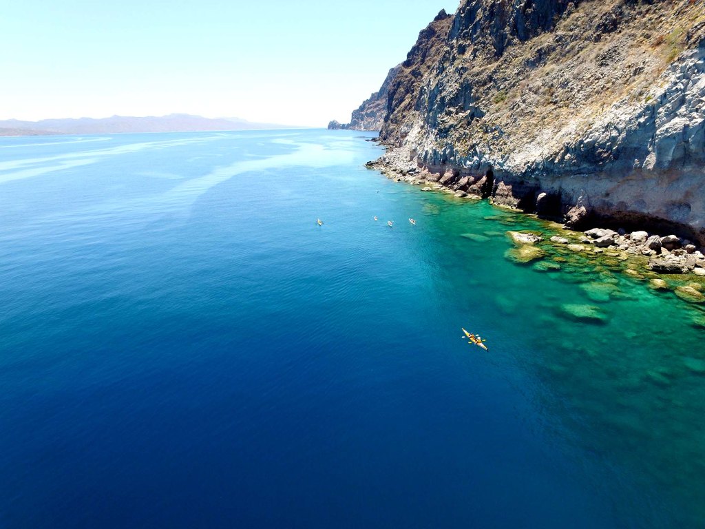
If you’ve ever looked out at the vastness of the ocean, you might think it’s a uniformly barren and flat landscape below the tranquil or tempestuous waves. But you’d be mistaken. Imagine for a moment a hidden world of underwater mountains, volcanoes that never broke the water’s surface, all lying in the mysterious depths of the ocean. These enigmatic formations are known as seamounts, and off the coast of California, they constitute an environment as fascinating as it is vital. 

Interestingly, a lot of these seamounts off California are actually relatively new to science. According to Robert Kunzig and his book Mapping the Deep: “In 1984, a sidescan survey off southern California revealed a hundred uncharted seamounts, or undersea volcanoes, in a region that had been thought to be flat.”

The genesis of these structures begins with a geologic process known as plate tectonics. As tectonic plates move beneath the Earth’s crust, they create hotspots of molten rock. This magma escapes through weak points in the crust and solidifies as it reaches the cold seawater, gradually building up into an undersea mountain. After thousands of years, a seamount is born. Most of California’s seamounts are conical in shape, though erosion and other geological forces can turn them into more complex formations over time. 

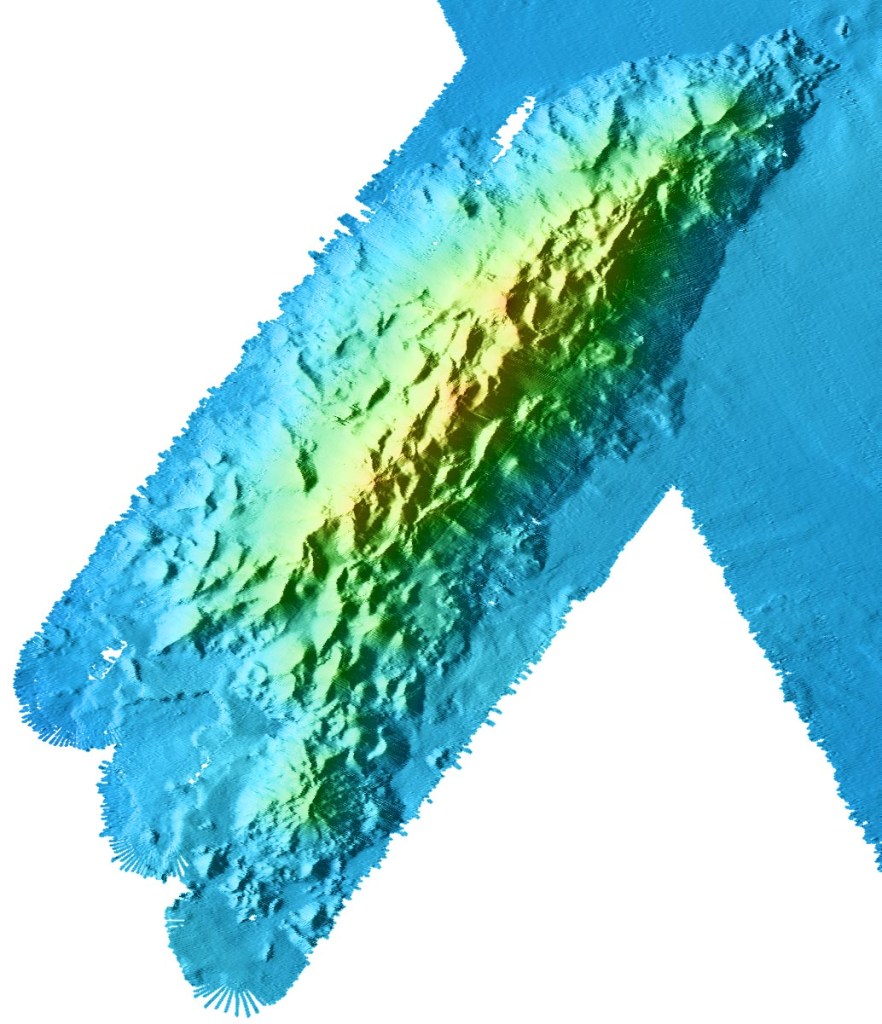
Each seamount is a world unto itself, with distinct mineral compositions, shapes, and ecosystems. Recent research has energized the scientific community. For instance, the Davidson Seamount is the most well-known of these volcanoes and was the first underwater peak to be named a seamount. The seamount is named for George Davidson, a British pioneering scientist and surveyor. Located about 80 km (50 miles) off the coast of Big Sur, it’s shaped like an elongated arrowhead made up of several parallel ridges of sheer volcanic cones. Most of these erupted about 10-15 million years ago, and are made up 320 cubic km of hawaiite, mugearite, and alkalic basalt, the basalt types commonly found along spreading ridges like the Mid-Atlantic Ridge. 

Davidson Seamount, Wikipedia

The sheer number of seamounts only began to emerge when new detection methods were developed, including the ability to spot them from space. These underwater mountains are so massive that they create a gravitational pull, drawing seawater slightly toward their center of mass, much like the moon’s pull generates tides. Since seawater is incompressible, it doesn’t compress around the seamounts but instead forms slight bulges on the ocean surface. Satellites can detect these bulges, helping locate the hidden, basaltic peaks below. Satellite studies suggest that the largest seamounts—those over 5,000 feet—may number anywhere from thirty thousand to over one hundred thousand worldwide, with high concentrations in the central Pacific, Indian, and Atlantic Oceans, around Antarctica, and in the Mediterranean. Each of these seamounts is an underwater volcano, typically lining mid-ocean ridges, subduction zones, or one of the forty to fifty oceanic hot spots where the earth’s crust is thin and magma rises from the mantle.

Davidson Seamount is by far the best-studied of the many seamounts off the California coast. Stretching a sprawling 26 miles in length and spanning 8 miles across, this colossal seamount ranks among the largest known formations of its kind in U.S. territorial waters. Towering at a remarkable 7,480 feet from its base to its peak, the mountain remains shrouded in the depths, with its summit situated a substantial 4,101 feet beneath the ocean’s surface. Studies have indicated that some seamounts contain deposits of rare earth elements, which could have potential economic importance in the future. 

A rorqual whale fall found near Davidson Seamount at a depth of 3,200 meters. Photo Credit: Chad King / OET, NOAA

Seamounts are biodiversity hotspots. Boasting an incredibly diverse range of deep-sea corals, Davidson Seamount serves as a kind of underwater Eden. Often referred to as “An Oasis in the Deep,” this submerged mountain is a bustling metropolis of marine life, featuring expansive coral forests and sprawling sponge fields. But it doesn’t stop there—crabs, deep-sea fishes, shrimp, basket stars, and a host of rare and still-unidentified bottom-dwelling creatures also call this place home. The seamount is more than just a biologically rich environment; it’s a treasure trove of national importance for its contributions to ocean conservation, scientific research, education, aesthetics, and even history.

Map of seamounts along the California coast. (Marine Conservation Institute)

Perhaps the most astonishing discovery at Davidson Seamount occurred in 2018, when scientists discovered the “Octopus Garden,” the largest known aggregation of octopuses in the world. The garden is about two miles deep and was discovered by researchers on the research vessel (RV) Nautilus. The team of scientists initially spotted a pair of octopuses through a camera on a remotely operated vehicle (ROV). Amanda Kahn, an ecologist at Moss Landing Marine Laboratories and San Jose State University, who was on the Nautilus during the discovery, told Scientific American that after observing the pair for a bit, the operators started to drift away from the rocks to move on, but immediately saw something unusual. “Up ahead of us were streams of 20 or more octopuses nestled in crevices,” Kahn says.

Typically lone wanderers of the ocean, octopuses aren’t known for their social gatherings. So, when researchers stumbled upon more than just one or two of these creatures, they knew something out of the ordinary was afoot. Swiftly pivoting from their original plans, the team zeroed in for a closer look. What they found was a community of these grapefruit-sized, opalescent octopuses, along with something even more mysterious—unusual shimmers in the surrounding water, hinting at the existence of some kind of underwater fluid seeps or springs. It turns out the octopuses migrate to deep-sea hydrothermal springs to breed. The females brood their eggs in the garden, where it is warmer than surrounding waters.

“This Octopus Garden is by far the largest aggregate of octopuses known anywhere in the world, deep-sea or not,” James Barry, a benthic ecologist at the Monterey Bay Aquarium Research Institute told Scientific American. Barry is the leader of the new study, published on in August in Science Advances, that reveals why the animals are gathering.  The researchers have observed over 5,700 Pearl octopuses (Muusoctopus robustus) breeding near Davidson Seamount, 3,200 meters below the ocean’s surface. In this deep-sea nursery, octopus mothers keep their eggs warm in 5°C waters flowing from a hydrothermal spring. The water is more than 3°C warmer than the surrounding ocean. This added warmth accelerates the embryos’ development, allowing them to fully mature in just under two years on average.

The Octopuses Garden was studied over the course of 14 dives with MBARI’s remotely operated vehicle (ROV) Doc Ricketts. It is within the Monterey Bay National Marine Sanctuary, so it is federally protected against exploitation and extraction., although many scientists are concerned that global warming could end up having a deleterious impact on the biological life found around seamounts.

So far scientists have discovered other octopus gardens around the globe. There are four deep-sea octopus gardens in total. Two are located off the coast of Central California and two are off the coast of Costa Rica.

New technological advancements like Remotely Operated Vehicles (ROVs) have recently opened doors to discoveries we never thought possible. Cutting-edge imaging technology has finally given us the ability to capture strikingly clear and high-resolution pictures from this enigmatic deep-sea habitat. These vivid images provide both the scientific community and the general public with unprecedented peeks into the lives of rare marine species inhabiting this mostly cold and dark underwater world.

Depth color-coded map of Monterey Canyon. (Monterey Bay Aquarium Research Institute)

Davidson Seamount’s proximity to the rich educational and research ecosystem in the Monterey Bay area. One of the world’s preeminent ocean research organizations, the Monterey Bay Research Institute (MBARI), is located in Moss Landing, California, right at the spot where the magnificent Monterey Canyon stretches away from the coast for hundreds of miles. This geographic boon makes it easier for interdisciplinary teams to join forces, enriching our understanding and educational outreach related to this uniquely captivating undersea landscape.

Beyond being hubs of biodiversity, seamounts also serve as waypoints for migratory species. Just like rest stops along a highway, these underwater mountains provide food and shelter for creatures like whales and tuna on their long journeys. This makes seamounts critical for the health of global marine ecosystems. Additionally, understanding seamounts could give us insights into climate change. They play a role in ocean circulation patterns, which, in turn, affect global weather systems. They are also excellent “archives” of long-term climate data, which could help us understand past climate variations and predict future trends.

Advances in underwater technology, like ROVs, autonomous submersibles and better remote sensing methods, are making it easier to study these mysterious mountains. But many questions still remain unanswered. For instance, how exactly do seamount ecosystems interact with surrounding marine environments? What are the long-term impacts of human activities, like deep-sea mining or overfishing, on these fragile habitats? And what untapped resources, both biological and mineral, lie waiting in these submerged summits?

A time-lapse camera designed by MBARI engineers allowed researchers to observe activity at the
Octopus Garden between research expeditions. (Photo: MBARI)

We can wax poetic about the mysteries of seamounts, but understanding them better is crucial for the preservation of marine ecosystems and for equipping ourselves with the knowledge to tackle environmental challenges. So, the next time you look out over the ocean, consider the hidden worlds lying beneath those waves—each a bustling metropolis of life and a potential goldmine of scientific discovery.

More information:

Video about California seamounts

Recent discovery of the Octopuses garden (MBARI).

.

Baja California Is Slowly Breaking Away from the Mainland and May One Day Become an Island

Baja California and the Sea of Cortez (Photo: Erik Olsen)

Geological forces are always at work, reshaping the planet, just usually on a timescale too slow for us to notice. But over the long haul, they can completely transform places we think of as fixed and familiar, like Southern California and northern Mexico. I’ve been down to Baja a bunch of times, including a few unforgettable multi-day kayak trips in the Sea of Cortez. Paddling past sheer cliffs and sleeping on empty beaches under the stars, it’s easy to feel like the landscape has been frozen in time. But that sense of permanence? It’s an illusion.

Baja California stretches like a crooked finger pointing toward the tropics, wedged between the restless Pacific and the calm, warm waters of the Gulf of California. This long, skinny slice of land, more than 1,200 miles from Mexicali to Cabo, is full of contrasts: sun-blasted deserts, jagged mountains, hidden oases and mangroves. But it’s not just a finger of land: it’s a fracture. Baja was ripped from mainland Mexico by slow, grinding tectonic forces, the Pacific Plate dragging it north and leaving the Gulf in its wake. And it’s still on the move.

Kayaking the Sea of Cortez out of Loreto, Mexico on the Baja Peninsula (Photo: Erik Olsen)

Every year, Baja creeps a little farther away from the continent, slowly widening the gap. Some scientists think that, millions of years from now, the whole rift could flood, turning parts of northern Mexico into a vast inland sea. It’s the continent, cracking apart right under our feet. it’s just taking its time.

This process is linked to the activity of the San Andreas Fault and other associated fault systems, which collectively form a boundary between the Pacific Plate and the North American Plate. The movement of these tectonic plates is a slow but relentless process, occurring over millions of years. (Slow, and yet as we’ve documented, there’s been quite a bit of movement over that long period of time).

The Pacific Plate is moving northwest relative to the North American Plate, and the San Andreas Fault system primarily accommodates this movement. In essence, the Baja California Peninsula is moving with the Pacific Plate alongside and away from the North American Plate. 

The separation is taking place at an average rate of about 2 to 5 centimeters per year. Over millions of years, these movements accumulate, leading to significant shifts in the geography of regions like Baja California. According to some geologists, within the next 20-30 million years, this tectonic movement could eventually break Baja and the westernmost part of California off of North America to create a vast inland sea, if not an island.

The movement of the continental crust in the area is due in part to seafloor spreading at a massive underwater seam called the East Pacific Rise. This mid-ocean ridge stretches from the southeastern Pacific near Antarctica all the way north into the Gulf of California. Its northernmost extension, known as the Gulf of California Rift Zone, reaches close to the mouth of the Colorado River, helping drive the slow but steady separation of the Baja California Peninsula from mainland Mexico.

Check out our Etsy store for California wildlife gifts.

That geological rift didn’t just shape the land—it created an entirely new sea. The story of Baja California’s tectonic journey isn’t just about earthquakes and shifting plates, it’s also a story of water. The Gulf of California, also known as the Sea of Cortez, is a geologically young sea, having formed around 5.3 million years ago when the Baja Peninsula began drifting northwest. That rifting process continues today, slowly widening the gulf and redrawing the landscape of northwest Mexico.

The azure waters of the Sea of Cortez (Photo: Erik Olsen)

This body of water is a critical habitat for marine life, including several species of whales and dolphins that depend on its warm waters. Jacques Cousteau, the famous French oceanographer, famously referred to the Gulf of California as “the world’s aquarium” due to its vast array of (declining) marine life.

The Sea of Cortez today is under threat from our short time so far on the planet. Unfortunately, overfishing and pollution, including nitrogen-rich runoff from the Colorado River, which (sort of) flows directly into the gulf, imperils wildlife. Nutrient flows can lead to a dramatic decrease in oxygen, depriving plants and animals of the life-giving gas. The potential extinction of the critically endangered vaquita (Phocoena sinus), represents one of the most urgent conservation crises in the region. The vaquita is the world’s most endangered marine cetacean, with estimates suggesting only a few individuals remain. This dire situation is primarily due to bycatch in illegal gillnets used for fishing another endangered species, the totoaba fish, whose swim bladder is highly valued in traditional Chinese medicine.

Habitat destruction is another growing concern, as mangroves, estuaries, and reefs, vital for the breeding and feeding of marine species, are increasingly destroyed to make way for tourism infrastructure and coastal development. Climate change intensifies these problems, with rising sea temperatures and ocean acidification threatening reefs and the broader ecosystem.

Baja California as seen in April 1984, from the bay of a Space Shuttle  (Photo: NASA)

The birth of the Sea of Cortez also has an intriguing connection to a body of water hundreds of miles to the north: the Salton Sea. The Salton Sea, California’s largest lake, sits in the Salton Trough, an area geologists consider a “rift zone,” an extension of the same tectonic forces at work in the Gulf of California.

As the North American and Pacific Plates continue their slow-motion dance, the area around the Salton Sea may sink further, eventually linking with the Gulf of California. If this occurs, seawater could flood the basin, creating a new body of water significantly opening the Sea of Cortez. As mentioned above, eventually this could lead to the full separation of the peninsula from the mainland. However, such a dramatic event is likely millions of years in the future, if it happens at all. Interestingly, the Salton Sea acts as a mirror, reflecting the past processes that led to the formation of the Sea of Cortez.

Salton Sea (Wikipedia)

The Sea of Cortez stands at a crossroads, shaped by both human impact and tectonic drift. Baja California is slowly pulling away from mainland Mexico, a process that could one day create a vast inland sea and dramatically reshape the region. While no one alive today will witness the full transformation, its ultimate impacts could be extreme—redrawing coastlines, shifting ecosystems, and isolating parts of southern California and Mexico in ways we can scarcely imagine.

Ghost of the West: The Tragic Story of the California Grizzly Bear’s Journey from Wilderness to State Flag

In the expansive and diverse landscape of California, many iconic animals are an integral part of the state’s reputation for natural beauty and untamed wilderness. Yet, one particular creature looms larger in the Californian narrative than many others – a species that has been extinct for nearly a century, but lives on as a powerful symbol: the California Grizzly Bear (Ursus arctos californicus).

The California Grizzly Bear, a subspecies of the Grizzly Bear, was a formidable presence in the wild terrains of California. This remarkable beast could grow up to 8 feet tall when standing on its hind legs, and adult males often weighed in excess of 2000 pounds. They sported a lustrous fur coat that varied in color from blond to dark brown, making them a striking, and sometimes terrifying, sight in the California wilderness.

The famous California Grizzly “Monarch” was housed in an enclosure at Golden Gate Park around 1910.
It passed away the following year. (California State Archives)

The name “Grizzly” could have meant “grizzled,” a term referring to the animal’s golden and grey tips of hair. Or quite possibly it meant “fear-inspiring” (as a phonetic spelling of “grisly”). The naturalist George Ord formally classified it in 1815 as Ursus horribilis (“terrifying bear”).

This giant was an omnivore with a varied diet that changed with the seasons. The bear’s dietary staples included seeds, berries, roots, fish, and small mammals. But the California Grizzly was also known to take down larger prey, such as deer and elk, when the opportunity presented itself. The first recorded encounters with California grizzly bears are found in diaries kept by several members of the 1769 Portola expedition, the first European land exploration of the southern stretch of the West Coast. Several place names that include the Spanish word for bear (oso) trace their origins back to that first overland expedition. For example, the city of Los Osos

Prior to Spanish settlement in the second half of the 1700s, it is estimated that 10,000 grizzly bears inhabited what is today considered modern-day California.

CALIFORNIA CURATED ON ETSY

Purchase stunning art prints of iconic California scenes.
Check out our Etsy store.

Stories about the California Grizzly Bear echo throughout the annals of California’s history and literature. In his book “The Mountains of California,” renowned naturalist John Muir recounted his encounters with these awe-inspiring creatures, stating, “When I discovered him, he was standing in a narrow strip of meadow, and I was concealed behind a tree on the side of it.”

California State Flag featuring the California Grizzly

As enduring as any mountain or redwood forest, the legacy of the California Grizzly Bear persists in the emblem of the state flag.

The inclusion of the grizzly bear on the California flag traces its roots back to a revolt in 1846, before California was a part of the United States. At the time, California was under Mexican rule and a group of American settlers staged a revolt known as the Bear Flag Revolt, in which they declared California to be an independent republic.

The settlers needed a flag to represent their new republic, so they designed a simple flag that included a grizzly bear, a single red star (inspired by the lone star of Texas), and the words “California Republic.” The grizzly bear was chosen because it was seen as a powerful and formidable creature, much like the settlers saw themselves. It was intended to represent strength, unyielding resistance, and independence. The republic was short-lived, however, because soon after the Bear Flag was raised, the U.S. military began occupying California, which went on to join the union in 1850.

The man who drew the bear on the original flag, William L. Todd, was a cousin of Mary Todd Lincoln, the wife of Abraham Lincoln. Unfortunately, Todd was not a great artist, and his bear looked more like a pig, which led to some ridicule and a new design.

The original California state flag, as designed by William L. Todd

In 1911, the design of the flag was standardized, and the grizzly bear became the central figure that we recognize today. The bear depicted on the flag is named “Monarch” after the last California grizzly bear captured and held in captivity. Monarch was captured in 1889 by newspaper reporter Allan Kelly, at the behest of William Randolph Hearst. Monarch’s remaining life was not pleasant. He spent his remaining 22 years in captivity, and was moved to Woodwards Gardens in San Francisco, and then to the zoo at Golden Gate Park. After the bear’s death in 1911, it was mounted and preserved (ahem, poorly) at the Academy of Sciences at Golden Gate Park.

Monarch on display. (Wikipedia)

Despite its iconic status, the California Grizzly Bear could not withstand the pressures of expanding human civilization. The arrival of settlers during the California Gold Rush in the mid-19th century marked the beginning of the end for the bear. As the human population exploded, the bears’ natural habitats were destroyed to make way for towns and agriculture. Additionally, the bear, seen as a threat to livestock and a danger to humans, was hunted extensively.

By the early 20th century, the California Grizzly Bear was on the brink of extinction. The last confirmed sighting of a California grizzly bear occurred in 1924 within Sequoia National Park. This marked the end of the species’ presence in the state, following decades of hunting and habitat loss. Prior to this, the last known grizzly in Southern California was killed in 1916 near Sunland, in the San Fernando Valley. The California grizzly, once abundant throughout the region, was declared extinct in the wild by the mid-1920s. The California Grizzly was declared extinct in 1924.

In recent years, discussions have emerged about the feasibility of reintroducing grizzly bears to California. Research indicates that the state possesses substantial suitable habitat for grizzlies, particularly in the Sierra Nevada and other mountainous regions. Some studies suggest that California could support a population of approximately 500 grizzly bears. ​

In 2014, the Center for Biological Diversity filed a legal petition urging the U.S. Fish and Wildlife Service to expand grizzly bear recovery efforts across the American West, including California. The petition identified 110,000 square miles of potential grizzly habitat in areas such as the Sierra Nevada. However, the U.S. Fish and Wildlife Service rejected this petition, citing concerns about habitat suitability and potential human-bear conflicts. ​

California grizzly taxidermy specimen at the Santa Barbara Museum of Natural History (Vahe Martirosyan)

The following year, in 2015, the Center for Biological Diversity initiated a petition directed at the California state legislature to reintroduce grizzly bears to the state. This effort aimed to raise public awareness and encourage state officials to explore the possibility of reintroduction. Despite these initiatives, the California Department of Fish and Wildlife has expressed reservations, emphasizing the significant changes in the state’s landscape and human population density since the grizzly’s extirpation. Officials have highlighted the potential challenges of human-bear interactions, given California’s current population of nearly 40 million people.

The debate over reintroducing grizzly bears to California continues, balancing ecological restoration goals with concerns about human safety and land use. While the state retains areas that could potentially support grizzlies, the complexities of modern coexistence present significant challenges to reintroduction efforts.

The Desert Tortoise: A Resilient Survivor of the Mojave

a close-up of a desert tortoise

The Mojave Desert, a harsh yet strikingly beautiful landscape that extends across four western U.S. states, is home to an equally fascinating and resilient creature: the desert tortoise (Gopherus agassizii). This fascinating reptile has evolved to survive in one of the world’s most inhospitable environments, but today, it faces numerous threats that are jeopardizing its existence.

The desert tortoise is a tortoise species in the family Testudinidae native to the Mojave and Sonoran deserts. They are specially adapted to withstand the extreme conditions of their desert habitat. Desert tortoises can tolerate water, salt, and energy imbalances on a daily basis, which increases their lifespans. On average, adult desert tortoises measure between 10 to 14 inches in shell length and weigh from 8 to 15 pounds. They have a high-domed shell, typically brownish in color, which serves as protection from predators. Their strong, stocky limbs are adapted for digging, an essential behavior for both foraging and creating burrows for shelter.

One of the desert tortoise’s most fascinating adaptations is its ability to store water. They have a large urinary bladder that can store over 40% of the tortoise’s body weight in water, urea, uric acid, and nitrogenous wastes. During the hot, dry summer months, this stored water can be reabsorbed back into the tortoise’s system, effectively allowing them to survive up to a year without access to fresh water.

a close-up of a desert tortoise

Desert tortoises are a testament to survival, with their lineage dating back 15 to 20 million years. They are primarily herbivorous, with a diet consisting of a variety of desert grasses, herbs, and wildflowers, along with the occasional consumption of insects and new growth of cacti.

Tortoises spend much of their lives in burrows, which provide refuge from extreme heat, cold, and predators. They are most active during the cooler hours of the day, and their activity pattern shifts with the changing seasons. Mating typically occurs in the spring and fall, with females laying a clutch of up to 15 eggs, though the survival rate of these hatchlings is low due to predation and harsh environmental conditions.

In 2011, on the basis of DNA, geographic, and behavioral differences between desert tortoises east and west of the Colorado River, it was decided that two species of desert tortoises exist: Agassiz’s desert tortoise (Gopherus agassizii) and Morafka’s desert tortoise (Gopherus morafkai). The new species name is in honor of the late Professor David Joseph Morafka of California State University, Dominguez Hills.

Desert tortoises spend 95% of their lives in their burrow. Seeing them on the landscape is a rare treat.

Estimates suggest that the population of desert tortoises has plummeted by as much as 90% since the mid-20th century. This decline is due to a variety of factors, including habitat loss from urban development and agriculture, road mortality, predation by dogs and other introduced species, and disease. In particular, upper respiratory tract disease (URTD), caused by the bacterium Mycoplasma agassizii, has been responsible for significant mortality.

Recognizing the threats faced by the desert tortoise, the U.S. Fish and Wildlife Service listed the species as threatened under the Endangered Species Act in 1990. This has led to numerous conservation efforts aimed at preserving the desert tortoise and its habitat.

Habitat conservation is a key focus, with several Desert Wildlife Management Areas established to protect crucial tortoise habitats. Efforts are also being made to reduce the impact of roads and highways on tortoise populations, such as the construction of underpasses and fencing along known tortoise crossing areas.

Education and public engagement are also critical components of conservation efforts. Initiatives are underway to educate the public about the desert tortoise and the importance of not removing them from their natural environment, a practice that can lead to population decline and the spread of disease.

Over the past few decades, desert tortoise populations have declined significantly, with estimates suggesting a staggering 90% reduction in some areas of the Mojave Desert. This decline has led to the desert tortoise being listed as “threatened” under the U.S. Endangered Species Act.

Desert tortoise facts
Lifespan: 30-50 years, but some can live to be over 80 years old
Weight: 8-15 pounds (3.5-7 kilograms)
Length: 9-15 inches (23-38 centimeters)
Range: Only found in the Mojave Desert in California, Nevada, Arizona, and Utah
Conservation status: Listed as threatened under the Endangered Species Act

Nature Conservancy

Numerous factors contribute to this decline, including habitat loss due to urbanization, off-road vehicle use, and livestock grazing. Additionally, the introduction of non-native predators, such as the common raven, has led to increased predation on juvenile tortoises.

Conservation organizations, government agencies, and local communities have come together to implement various strategies aimed at protecting and preserving the desert tortoise. These efforts include habitat restoration, fencing off sensitive areas, and developing educational programs to raise awareness about the species.

One such initiative is the “Adopt-a-Tortoise” program, which allows individuals and organizations to symbolically adopt a tortoise, with the proceeds going towards conservation efforts. Another important initiative is the “Head Start” program, which raises hatchlings in captivity until they reach a size less vulnerable to predators before releasing them into the wild.

California’s Common, but Lovely, Birds: the House Finch

House Finch

California is home to an impressive number of bird species, with over 700 recorded throughout the state. From the rocky shores of the Pacific coast to the towering peaks of the Sierra Nevada, California’s diverse landscapes provide habitats for a wide range of birdlife. Many of these species are endemic to California, meaning they are found nowhere else in the world. The state’s unique geography and climate, as well as its location on the Pacific Flyway migration route, make it a haven for birdwatchers and ornithologists alike.

One of the most common birds in California, probably familiar to anyone whether a backyard enthusiast or committed ornithologist is the house finch. The house finch (Haemorhous mexicanus) is a small passerine (perching) bird that is native to western North America, including California. This bird is widely known for its vibrant red plumage and melodic song, making it a beloved sight and sound in backyards across the state.

House finches are a member of the finch family, Fringillidae, which includes all true finches. They are thought to have originated from the deserts of Mexico and the southwestern United States. Their range has since expanded to cover much of North America.

Finches are famously associated with Charles Darwin and his theory of evolution by natural selection. During his voyage on the HMS Beagle, Darwin observed finches on the Galápagos Islands, noting the significant variations in their beak shapes and sizes. These differences were adaptations to the specific diets available on their respective islands. Darwin’s study of these finches helped him develop the concept that species evolve over time through natural selection, where advantageous traits become more common in a population. This observation provided crucial evidence for his groundbreaking work, “On the Origin of Species.”

House finches are small birds, measuring about 5-6 inches in length and weighing between 0.6-1.0 ounces. They have a stout, conical beak that is adapted for cracking open seeds, their primary source of food. The male house finch is easily recognizable by its bright red head and breast, while the female has a duller brownish-gray coloration. However, in some areas, there are color variations in the males, such as yellow, orange, or even a rose-pink color.

House finches primarily feed on seeds, including those from sunflowers, dandelions, thistles, and various grasses. They are also known to eat some fruits and insects, particularly during the breeding season when protein is essential for the growth of their young. House finches have a unique feeding habit in that they use their tongue to extract seeds from the seed capsules, which they then crush with their beaks.

House finches are monogamous and form pair bonds during the breeding season, which typically starts in late winter and lasts through early summer. The male house finch will sing and perform courtship displays to attract a mate, often presenting the female with a gift of food. Once the pair has formed, they will work together to build a small nest using grass, twigs, and other plant materials.

House finches are a common sight in backyards, parks, and other areas with ample vegetation. They are often seen perched on wires, branches, or feeders, where they will socialize with other birds, including other finches, sparrows, and juncos. House finches are also known for their acrobatic abilities, often clinging to branches and twigs while feeding.

In addition to their acrobatics, house finches are known for their melodic song. Males will sing throughout the day, particularly during the breeding season, to attract mates and establish territories. The song of the house finch is a warbling melody that can be heard from a considerable distance.

House finch (Erik Olsen)

Research has shown that male house finches learn their songs from adult males, typically their fathers, during a critical period in their early life. This learning process is akin to how humans acquire language, involving both genetic predisposition and environmental influences. A study published in the journal “Animal Behaviour” found that house finch songs are composed of a variety of syllables that can be combined in numerous ways, leading to a wide range of unique songs within populations.

Interestingly, these songs play a crucial role in mate attraction and territorial defense. Females tend to prefer males with more complex and diverse songs, which are indicative of the male’s overall health and genetic fitness. Moreover, regional dialects have been observed, with finches in different geographic locations exhibiting distinct song patterns. This geographic variation is believed to result from both cultural transmission and genetic drift, making the house finch’s song an excellent model for studying the evolution of communication and social behavior in birds.

House finch painting

In California, house finches are a common sight and have adapted well to urban and suburban environments. They are often attracted to bird feeders, particularly those filled with sunflower seeds, which they can easily crack open with their beaks.

The house finch’s vibrant plumage, melodic song, and acrobatic abilities make it a joy to observe in the wild or in our own backyards. As with many bird species, it is essential that we continue to protect their habitats and ensure that they have access to adequate food sources to thrive.