The Salton Sea Was California’s Strangest Catastrophe

In California’s southeastern desert, the Salton Sea stretches across a wide, shimmering basin, a lake where there shouldn’t be one. At about 340 square miles, it’s the state’s largest lake. But it wasn’t created by natural forces. It was the result of a major engineering failure. I’ve long been fascinated with the place: its contradictions, its strangeness, its collision of nature and human ambition. It reflects so many of California’s tensions: water and drought, industry and wilderness, beauty and decay. And it was only relatively recently that I came to understand not just how the Salton Sea came to exist, but how remarkable the region’s geological past really is, and how it could play a major role in the country’s sustainable energy future.

In the early 1900s, the Imperial Valley was seen as promising farmland: its deep, silty soil ideal for agriculture, but the land was arid and desperately needed irrigation. To bring water from the Colorado River, engineers created the Imperial Canal, a massive infrastructure project meant to transform the desert into productive farmland. But the job was rushed. The canal had to pass through the Mexican border and loop back into California, and much of it ran through highly erodible soil. Maintenance was difficult, and by 1904, silt and sediment had clogged portions of the canal.

The Southern Pacific Railroad was forced to move it lines several times as the raging, unleashed Colorado River expanded the Salton Sea. (Credit: Imperial Irrigation District)

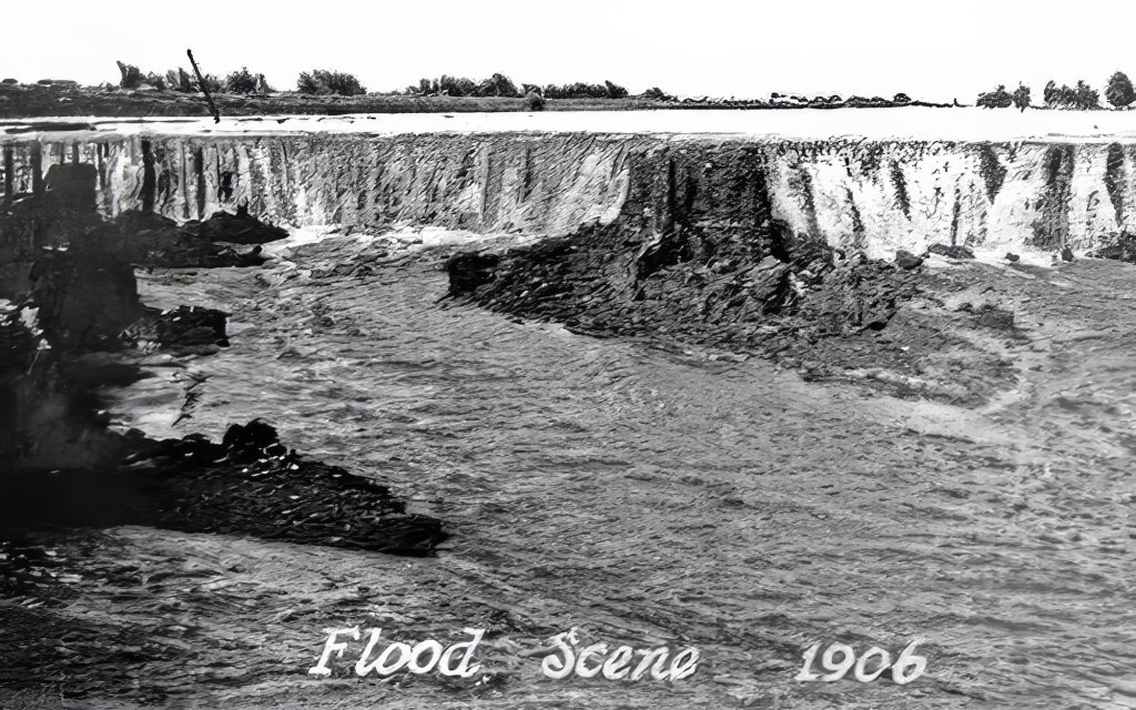
To keep water flowing, engineers hastily dug a temporary bypass channel south of the clogged area, hoping it would only be used for a few months. But they failed to build proper headgates, critical structures for controlling water flow. In 1905, an unusually heavy season of rain and snowmelt in the Rockies caused the Colorado River to swell. The torrent surged downriver and overwhelmed the temporary channel, carving it wider and deeper. Before long, the river completely abandoned its natural course and began flowing unchecked into the Salton Sink, an ancient, dry lakebed that had once held water during wetter epochs but had long since evaporated. (This has happened many times over in the region’s history).

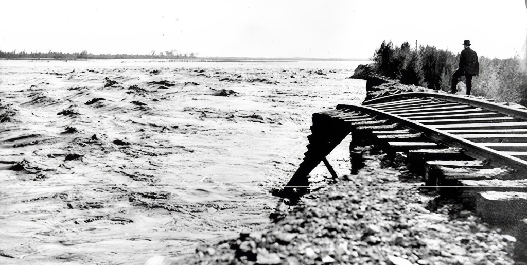
For nearly two years, the Colorado River flowed uncontrolled into this depression, creating what is now known as the Salton Sea. Efforts to redirect the river back to its original course involved a frantic, expensive engineering campaign that included the Southern Pacific Railroad and U.S. government assistance. The breach wasn’t fully sealed until early 1907. By then, the sea had already formed: a shimmering, accidental lake nearly 35 miles long and 15 miles wide, with no natural outlet, in the middle of the California desert.

In the 1950s and early ’60s, the Salton Sea was a glamorous desert escape, drawing crowds with boating, fishing, and waterskiing. Resorts popped up along the shore, and celebrities like Frank Sinatra, Jerry Lewis, Rock Hudson, the Beach Boys, and the Marx Brothers came to visit and perform. It was billed as a new Palm Springs with water, until rising salinity and environmental decline ended the dream. There have been few if any similarly starge ecological accidents like it.

The erosive power of the floodwaters was immense. The river repeatedly scoured channels that created waterfalls, which cut back through the ground, eroding soil at a rate of about 1,200 meters per day and carving gorges 15 to 25 meters deep and more than 300 meters wide. (Credit: Imperial Irrigation District)

The creation of the Salton Sea was both a blessing and a curse for the people of the Imperial Valley. On the one hand, the lake provided a new source of water for irrigation, and the fertile soil around its shores proved ideal for growing crops. On the other hand, the water was highly saline, and the lake became increasingly polluted over time, posing a threat to both human health and the environment.

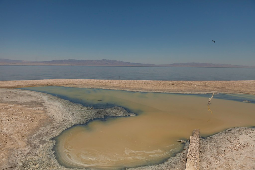
Recently, with most flows diverted from the Salton Sea for irrigation, it has begun to dry up and is now considered a major health hazard, as toxic dust is whipped up by heavy winds in the area. The disappearance of the Salton sea has also been killing off fish species that attract migratory birds.

California Curated Etsy

 The New York Times recently wrote about the struggles that farmers face as the Salton Sea disappears, and how the sea itself will likely disappear entirely at some point.

“There’s going to be collateral damage everywhere,” Frank Ruiz, a program director with California Audubon, told the Times. “Less water coming to the farmers, less water coming into the Salton Sea. That’s just the pure math.”

Salton Sea can be beautiful, if toxic (Photo: Wikipedia)

To me, the story of the Salton Sea is fascinating: a vivid example of how human intervention can radically reshape the environment. Of course, there are countless cases of humans altering the natural world, but this one feels particularly surreal: an enormous inland lake created entirely by accident, simply because a river, the Colorado, one of the most powerful in North America, was diverted from its course. It’s incredible, and incredibly strange. What makes the region even more fascinating, though, is that the human-made lake sits in a landscape already full of geological drama.

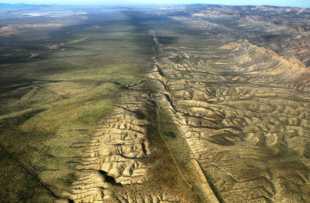
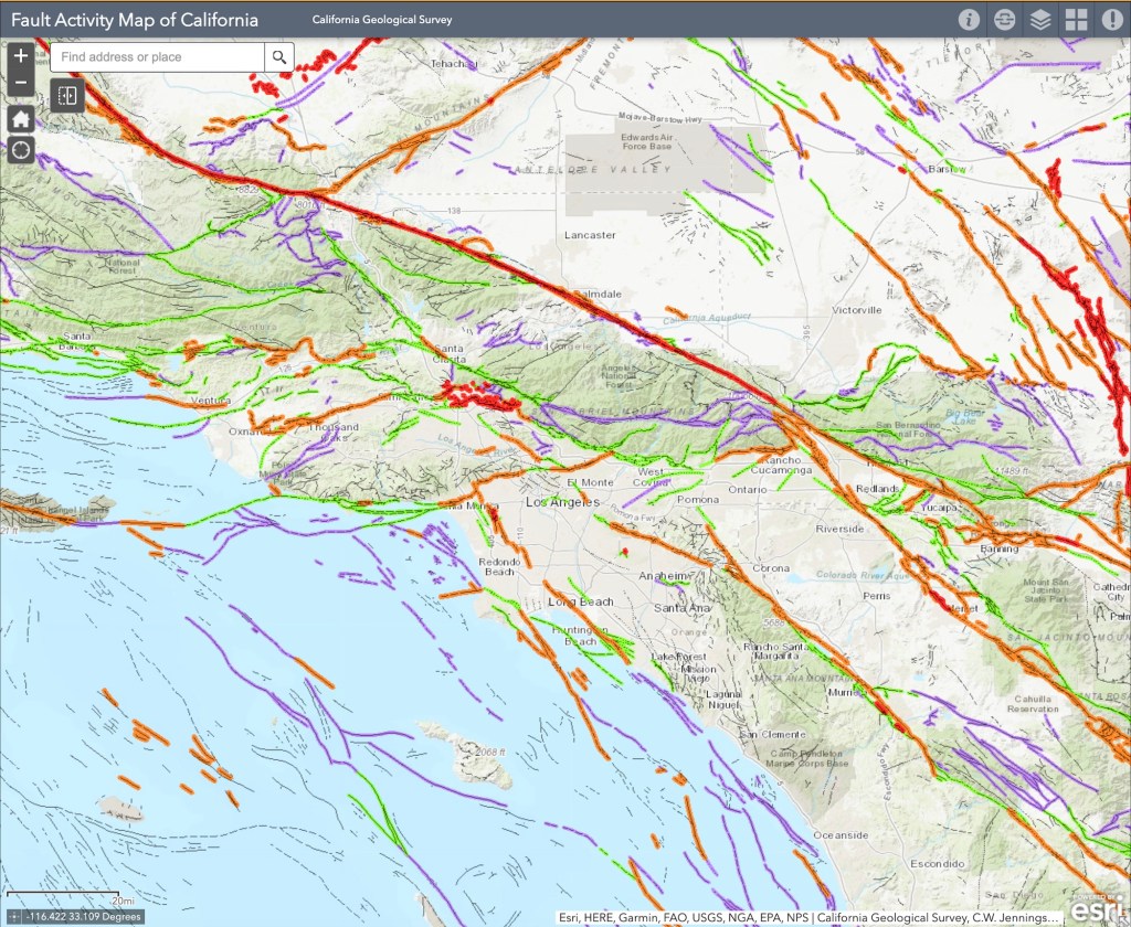
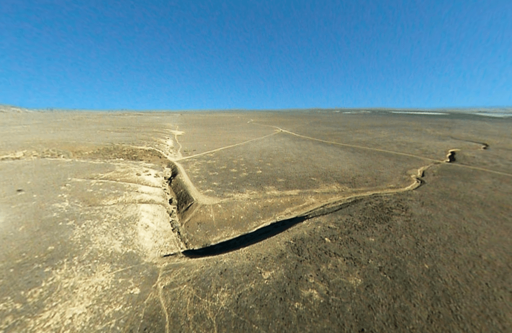
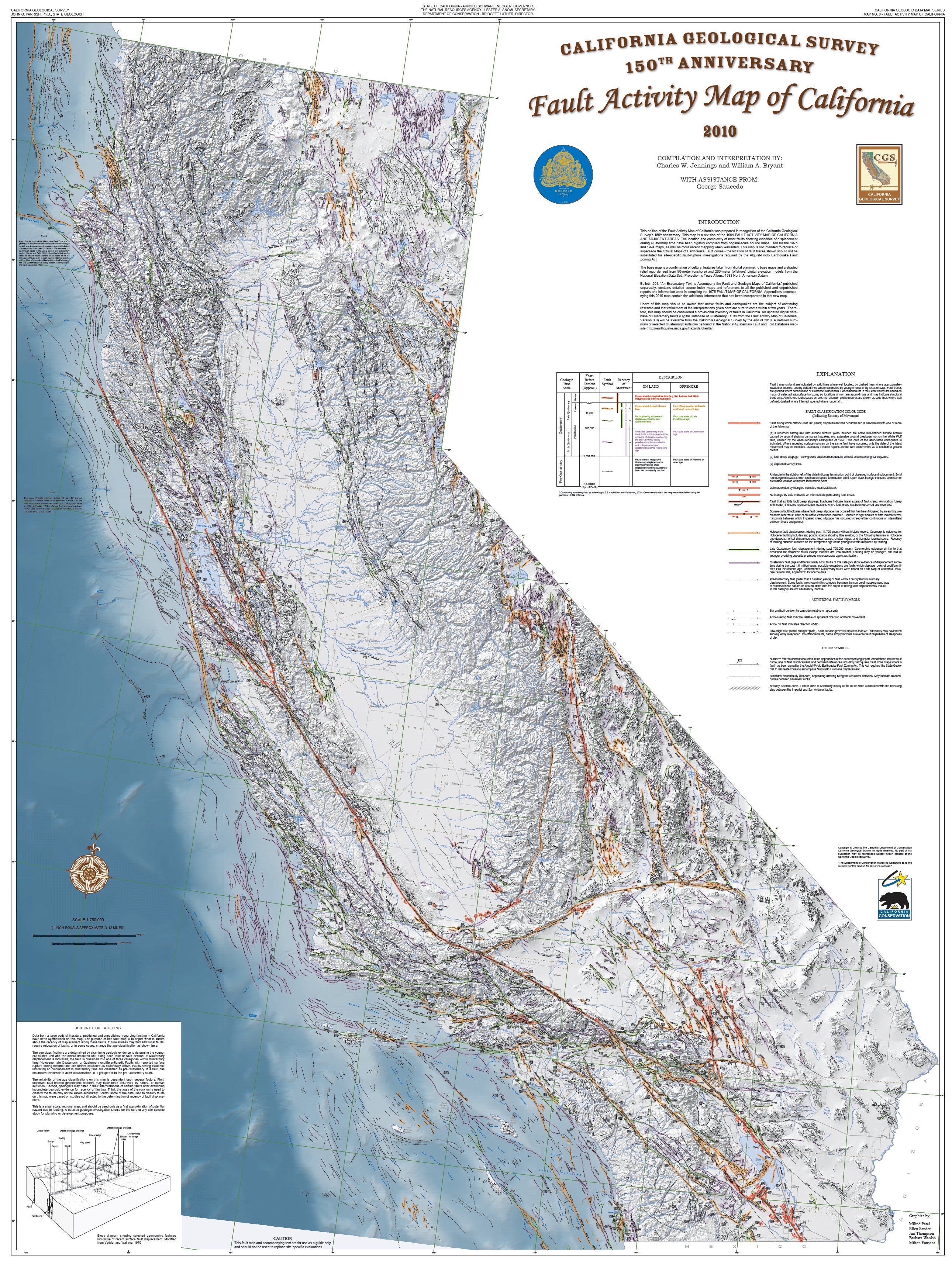
The area around the Salton Sea is located in a techtonically active region, with the San Andreas Fault running directly through it. The San Andreas Fault is a major plate boundary, where the Pacific Plate is moving north relative to the North American Plate (see our story about how fast it’s moving here). As pretty much every Californian knows, the legendary fault is responsible for the earthquakes and other tectonic activity across much of California.

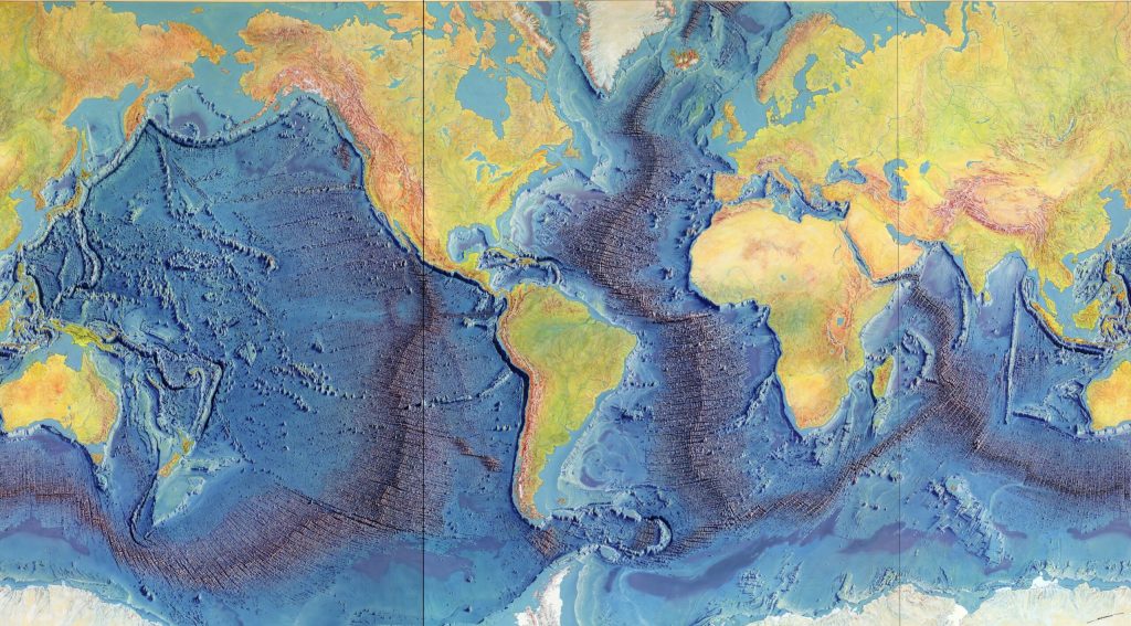
If you look at a map of the area, you can see how the low lying southern portion of the Salton Sea basin goes directly into the Gulf of California. Over millions of years, the desert basin has been flooded numerous times throughout history by what is now the Gulf of California. As the fault system cuts through the region, the Pacific Plate is slowly sliding northwest, gradually pulling the Baja Peninsula away from mainland Mexico. Over millions of years, this tectonic motion is stretching and thinning the crust beneath the Imperial Valley and Salton Basin. If the process continues, geologists believe the area could eventually flood again, forming a vast inland sea, perhaps even making an island out of what is today Baja California. (We wrote about this earlier.)

Entrance to the Salton Sea Recreation Area (Wikipedia)

Yet even as the land shifts beneath it, the Salton Sea’s future may be shaped not just by geology, but by energy. Despite the ongoing controversy over the evaporating water body, the Salton Sea may play a crucial role in California’s renewable energy future. The region sits atop the Imperial Valley’s geothermal hotspot, where underground heat from all that tectonic activity creates ideal conditions for producing clean, reliable energy. Already home to one of the largest geothermal fields in the country, the area is now gaining attention for something even more strategic: lithium.

An aerial view of geothermal power plants among the farmland around the southern shore of the Salton Sea.
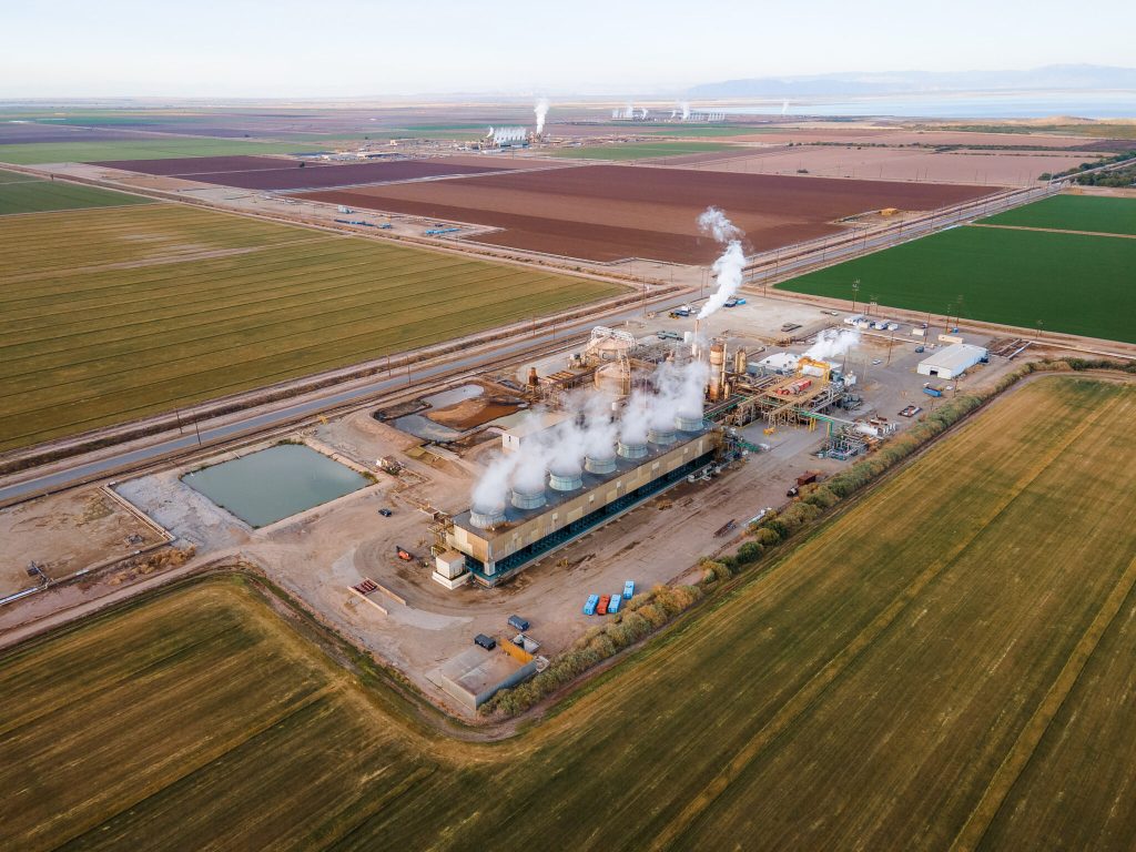
(Credit: Courtesy Lawrence Berkeley National Lab)

Beneath the surface, the hot, mineral-rich brine used in geothermal energy production contains high concentrations of lithium, a critical component in electric vehicle batteries. Known as “Lithium Valley,” the Salton Sea region has become the focus of several ambitious extraction projects aiming to tap into this resource without the large environmental footprint of traditional lithium mining. Gov. Gavin Newsom called the area is “the Saudi Arabia of lithium.” Even the Los Angeles Times has weighed in, claiming that “California’s Imperial Valley will be a major player in the clean energy transition.”

Companies like Controlled Thermal Resources (CTR) and EnergySource are developing direct lithium extraction (DLE) technologies that pull lithium from brine as part of their geothermal operations. The promise is a closed-loop system that produces both renewable energy and battery-grade lithium on the same site. If it proves viable, the Salton Sea could significantly reduce U.S. dependence on foreign lithium and cement California’s role in the global shift to clean energy. That’s a big if…and one we’ll be exploring in depth in future articles.

Toxic salt ponds along the Western shoreline (Photo: EmpireFootage)

Such projects could also potentially provide significant economic investment in the region and help power California’s green energy ambitions. So for a place that looks kind of wrecked and desolate, there actually a lot going on. We promise to keep an eye on what happens. Stay tuned.

Manzanitas are California’s Sculptured Survivors

At Inspiration Point, Yosemite, sticky whiteleaf manzanita tends to occupy south slopes, greenleaf manzanita tends to occupy north slopes. (Photo: NPS)

As an avid hiker in Southern California, I’ve become a deep admirer of the chaparral that carpets so many of the hills and mountains in the region. When I was younger, I didn’t think much of these plants. They seemed dry, brittle, and uninviting, and they’d often leave nasty red scrapes on your legs if you ever ventured off-trail.

But I’ve come to respect them, not only because they’ve proven to be remarkably hardy, but because when you look closer, they reveal a kind of beauty I failed to appreciate when I was younger. I’ve written here and elsewhere about a few of them: the fascinating history of the toyon (Heteromeles arbutifolia), also known as California holly, which likely inspired the name Hollywood and is now officially recognized as Los Angeles’ native city plant; the incredible durability of creosote bush, featured in a recent Green Planet episode with David Attenborough; and the laurel sumac, whose taco-shaped leaves help it survive the region’s brutal summer heat.

Manzanita branches in the high Sierra. The deep red colored bark enhanced by water. (Photo: Erik Olsen)

But there’s another plant I’ve come to admire, one that stands out not just for its resilience but for its deep red bark and often gnarled, sculptural form. It’s manzanita, sometimes called the Jewel of the Chaparral, and it might be one of the most quietly extraordinary plants in California.

If you’ve ever hiked a sun-baked ridge or wandered a chaparral trail, chances are you’ve brushed past a manzanita. With twisting, muscular limbs the color of stained terra cotta and bark so smooth it looks hand-polished, manzanita doesn’t just grow. It sculpts itself into the landscape, twisting and bending with the contours of hillsides, rocks, and other plants.

There are more than 60 species and subspecies of manzanita (Arctostaphylos), and most are found only in California. Some stand tall like small trees as much as 30 feet high; others crawl low along rocky slopes. But all of them are masters of survival. Their small, leathery leaves are coated with a waxy film to lock in moisture during the long dry seasons. They bloom in late winter with tiny pink or white bell-shaped flowers, feeding early pollinators when little else is flowering. By springtime, those flowers ripen into red fruits: the “little apples” that give the plant its name.

Manzanita flowers (Santa Barbara Botanical Garden)

One of manzanita’s more fascinating traits is how it deals with dead wood. Instead of dropping old branches, it often retains them, letting new growth seal off or grow around the dead tissue. You’ll see branches striped with gray and red, or dead limbs still anchored to the plant. It’s a survival strategy, conserving water, limiting exposure, and creating the twisted, sculptural forms that make manzanita distinctive.

And fire is key to understanding manzanita’s world. Like many California plants, many manzanita species are fire-adapted: some die in flames but leave behind seeds that only germinate after exposure to heat or smoke. Others resprout from underground burls after burning. Either way, manzanita is often one of the first plants to return to the land after a wildfire, along with laurel sumac, stabilizing the soil, feeding animals (and people), and shading the way for the next wave of regrowth.

Manzanita’s astonishing red bark The reddish color of manzanita bark is primarily due to tannins, naturally occurring compounds that also contribute to the bark’s bitter taste and deter insects and other organisms from feeding on it. (Photo: NPS)

Botanically, manzanitas are a bit of a mystery. They readily hybridize and evolve in isolation, which means there are tiny populations of hyper-local species, some found only on a single hill or canyon slope. That makes them incredibly interesting to scientists and especially vulnerable to development and climate change.

Their red bark is the result of high concentrations of tannins, bitter compounds that serve as a natural defense. Tannins are present in many plants like oaks, walnuts and grapes, and in manzanitas, they make the bark unpalatable to insects and animals and help resist bacteria, fungi, and decay. The bark often peels away in thin sheets, shedding microbes and exposing fresh layers underneath. It’s a protective skin, both chemical and physical, built for survival in the dry, fire-prone landscapes of California.

Whiteleaf manzanita leaves and berries (Photo: NPS)

The plants still have mysteries that are being uncovered. For example, a new species of manzanita was only just discovered in early 2024, growing in a rugged canyon in San Diego County. Named Arctostaphylos nipumu to honor the Nipomo Mesa where it was discovered and its indigenous heritage, it had gone unnoticed despite being located just 35 miles from the coast and not far from populated areas. The discovery, announced by botanists at UC Riverside, highlights that unique species localization, as the plants are found sometimes growing only on a single ridge or in a specific type of soil. Unfortunately, this newly identified species is already at risk due to development pressures and habitat loss. According to researchers, only about 50 individuals are known to exist in the wild, making A. nipumu one of California’s rarest native plants, and a reminder that the story of manzanita is still unfolding, even in places we think we know well.

A new species of manzanita – A. nipumu – was discovered in San Diego County last year (2024), surprising reserachers. (Photo: UCR)

For hikers, photographers, and anyone with an eye for the unusual, manzanita is a cool plant to stumble upon. I will often stop and admire a particularly striking plant. I love when its smooth bark peels back in delicate curls, looking like sunburned skin or shavings of polished cinnamon. It’s hard to walk past a manzanita without reaching out to touch that smooth, cool bark. That irresistible texture may not serve any evolutionary purpose for the plant, but it’s one more reason to wander into California’s fragrant chaparral, where more species of manzanita grow than anywhere else on Earth.

California Curated Etsy

California’s Wild Laboratory and The Evolutionary Wonders of the Channel Islands

Anacapa Island in California’s Channel Islands (Photo: Erik Olsen)

I recently took two scuba diving trips out to the Channel Islands to investigate and help remove ghost lobster traps: abandoned or lost gear that poses a serious threat to marine life. While out there, I also had a chance to explore the marine protected areas surrounding Anacapa and Santa Cruz Islands, getting a firsthand look at how these underwater reserves are helping to restore ocean health and marine life (another story on that coming). Diving in the Channel Islands is a great way for certified divers to experience the incredible biodiversity of California’s coastal waters, even if the water is cold as hell.

The Channel Islands are actually relatively close to the California mainland, just 12 miles from Ventura in the case of Anacapa. But the wild and windswept chain feels like a world apart. On a clear day, you can see them from Ventura or Santa Barbara, but oddly, few people actually visit. Compared to other national parks, they remain relatively unknown, which only adds to their quiet allure. Sometimes called the “Galápagos of North America,” these eight islands are a refuge for wildlife and a place where evolution unfolds before your eyes.

U.S. Park Service rangers patrol the marine protected area off of Anacapa Island in California’s Channel Islands
(Photo: Erik Olsen)

(Here’s a cool bit of history: there are eight Channel Islands today, but 20,000 years ago, during the last ice age when sea levels were much lower, four of them—San Miguel, Santa Rosa, Santa Cruz, and Anacapa—were connected as a single landmass called Santarosae.)

For scientists and nature lovers, the Channel Islands are more than just scenic, they’re a natural laboratory. Each island has its own shape, size, and ecological personality, shaped by millions of years of isolation. That makes them an ideal setting for the study of island biogeography, the branch of biology that looks at how species evolve and interact in isolated environments. What happens here offers insight into how life changes and adapts not just on islands, but across the planet.

Sea lions on the Channel Islands (NPS)

Island biogeography is anchored in the theory proposed by E.O. Wilson and Robert MacArthur in the 1960s. Their theory, focusing on the balance between immigration and extinction of species on islands, is brilliantly exemplified in the Channel Islands.

The Channel Islands’ rich mosaic of habitats, from windswept cliffs and rocky shores to chaparral-covered hillsides and dense offshore kelp forests, provides an ideal setting for studying how species adapt to varied and changing conditions. Each island functions like a separate ecological experiment, shaped by isolation, resource limits, and time. Evolution has had free rein here, tweaking species in subtle ways and, occasionally, producing striking changes.

One of the most significant studies conducted in the Channel Islands focused on the island fox (Urocyon littoralis), a species found nowhere else on Earth. Research led by the late evolutionary biologist Robert Wayne at UCLA and others showed that the fox populations on each of the six islands they inhabit have evolved in isolation, with distinct genetic lineages and physical traits. This makes them a remarkable example of rapid evolution and adaptive divergence, core processes in island biogeography.

Genetic analyses revealed that each island’s fox population carries unique genetic markers, shaped by long-term separation and adaptation to local environments. These differences aren’t just genetic, they’re physical and behavioral too. Foxes on smaller islands, for instance, tend to be smaller in body size, likely an evolutionary response to limited resources, a phenomenon known as insular dwarfism. Variations in diet, foraging behavior, and even coat coloration have been documented, offering scientists an unparalleled opportunity to study evolutionary processes in a real-world, relatively contained setting.

Excavation of pygmy mammoth bones on the Channel Islands (Photo: National Park Service)

This phenomenon of insular dwarfism isn’t unique to the island fox. One of the most striking examples from the Channel Islands is the pygmy mammoth (Mammuthus exilis), whose fossilized remains were discovered on Santa Rosa Island. Evolving from the much larger Columbian mammoth, these ancient giants shrank to about half their original size after becoming isolated on the islands during the last Ice Age. Limited food, reduced predation, and restricted space drove their dramatic transformation, a powerful illustration of how isolation and environmental pressures can reshape even the largest of species.

Furthermore, the Channel Islands have been instrumental in studying plant species’ colonization and adaptation. Due to their isolation, the islands host a variety of endemic plant species. Research by Kaius Helenurm, including genetic studies on species such as the Santa Cruz Island buckwheat (Eriogonum arborescens) and island mallow (Malva assurgentiflora), has shown how these plants have adapted to the islands’ unique environmental pressures and limited gene flow.

Island mallow (Malva assurgentiflora), a vibrant flowering plant found only on the Channel Islands, thrives in the harsh coastal environment—its striking blooms a testament to the power of isolation and adaptation. (Photo: Curtis Clark)

The islands have been a scientific boon to researchers over the decades because they are not only home to many diverse and endemic species, but their proximity to the urban centers and the universities of California make them amazingly accessible. It’s been suggested that if Darwin had landed on the Channel Islands, he arguably could have come up with the theory of natural selection off of California, rather than happening upon the Galapagos. A 2019 book about the islands, titled North America’s Galapagos: The Historic Channel Islands Biological Survey recounts the story of a group of researchers, naturalists, adventurers, cooks, and scientifically curious teenagers who came together on the islands in the late 1930s to embark upon a series of ambitious scientific expeditions never before attempted. 

The Channel Islands are renowned for their high levels of endemism — species that are found nowhere else in the world. This is a hallmark of island biogeography, as isolated landmasses often lead to the development of unique species. Darwin’s On the Origin of Species was one of the first extensive efforts to describe this phenomenon. For example, as mentioned above, the Channel Islands are home to the island fox (Urocyon littoralis), a small carnivore found only here. Each island has its own subspecies of the fox, differing slightly in size and genetics, a striking example of adaptive radiation, where a single species gives rise to multiple different forms in response to isolation and environmental pressures. That said, the foxes are also incredibly cute, but can be rather annoying if you are camping on the islands because they will ransack your food stores if you do not keep them tightly closed.

Island Fox on Santa Cruz Island (photo: Erik Olsen)

Bird life on the Channel Islands also reveals remarkable diversity and endemism. Much like the finches of the Galápagos, these islands are home to distinct avian species shaped by isolation and adaptation. The Santa Cruz Island Scrub Jay, for instance, is noticeably larger and more vividly colored than its mainland relatives, a reflection of its unique island habitat. Also, jays in pine forests tend to have longer, shallower bills, while those in oak woodlands have shorter, deeper bills. Evolutionary adaptations right out of the Darwinian playbook. Likewise, the San Clemente House Finch has evolved traits suited to its specific environment, illustrating how even common species can diverge dramatically when given time and separation.

The Island Scrub-Jay (Aphelocoma insularis), found only on Santa Cruz Island, is larger and more vividly colored than its mainland cousin—an unmistakable symbol of how isolation shapes evolution. (Photo: National Park Service)

The impacts of invasive species on island ecosystems, another critical aspect of island biogeography, are also evident in the Channel Islands. The islands have been an superb laboratory for the practice of conservation and human-driven species recovery. For example, efforts to remove invasive species, like pigs and rats, and the subsequent recovery of native species, like the island fox, provide real-time insights into ecological restoration and the resilience of island ecosystems.

These efforts at conservation and species recovery extend beyond the island fox. In 1997, the U.S. Fish and Wildlife Service identified that 13 plant species native to the northern Channel Islands in California were in dire need of protection under the Endangered Species Act. This need arose due to several decades of habitat degradation, primarily attributed to extensive sheep grazing. These conservation efforts have yielded good news. For instance, the island bedstraw (Galium buxifolium) expanded from 19 known sites with approximately 500–600 individuals in 1997 to 42 sites with over 15,700 individuals. Similarly, the Santa Cruz Island dudleya (Dudleya nesiotica) population stabilized at around 120,000 plants. As a result of these recoveries, both species were removed from the federal endangered species list in 2023, coinciding with the 50th anniversary of the Endangered Species Act.

Santa Cruz Island Dudleya (Photo: National Park Service)

Conservation efforts at the Channel Islands extend beneath the waves, where marine protected areas (MPAs) have played a crucial role in restoring the rich biodiversity of the underwater world. I’ve seen the rich abundance of sea life firsthand on several dives at the Channel Islands, where the biodiversity feels noticeably greater than at many mainland dive sites in Southern California.

The Channel Islands Marine Protected Areas (MPAs), established in 2003, were among the first of their kind in California. The MPAs around Anacapa, Santa Cruz, and other islands act as refuges where fishing and other extractive activities are limited or prohibited, allowing marine ecosystems to recover and thrive. Over the past two decades, scientists have documented increases in the size and abundance of key species such as kelp bass, lobsters, and sheephead, alongside the resurgence of lush kelp forests that anchor a vibrant web of marine life. These protections have not only benefited wildlife but have also created living laboratories for researchers to study ecological resilience, predator-prey dynamics, and the long-term impacts of marine conservation, all taking place in the context of island biogeography.

Kelp bass in the kelp forest at the Channel Islands (Photo: Erik Olsen)

What makes all of this possible is the remarkable decision to keep these islands protected and undeveloped. Unlike much of the California coast, the Channel Islands were set aside, managed by the National Park Service and NOAA as both a national park and a marine sanctuary. These protections have preserved not just the landscapes, but the evolutionary stories still unfolding in real time. It’s a rare and precious thing to have a living laboratory of biodiversity right in our backyard, and a powerful reminder of why preserving wild places matters.

The Scourge of Ghost Lobster Traps and the Battle to Save Marine Life in California

Ghost lobster trap off Santa Cruz Island in California’s Channel Islands (Photo: Erik Olsen)

Lobster is delicious. Let’s just get that out of the way. Yes, I’m sure there are some who either don’t enjoy the taste of this prolific crustacean, or who are allergic, but for my part, lobster (with a small vial of melted butter) is ambrosia from the sea.

But beyond its place on the plate, the California spiny lobster plays a vital ecological role: hunting sea urchins, hiding in rocky reefs, and helping to keep kelp forests in balance. Its value extends far beyond what it fetches at market. But beneath the surface, particularly around the Channel Islands lurks a growing problem that doesn’t just threaten lobsters. It threatens the entire marine ecosystem: ghost traps.

Dive ship Spectre off of Anacapa Island in California’s Channel Islands (Photo: Erik Olsen)

In Southern California, lobster fishing is both a cultural tradition and a thriving industry, worth an estimated $44 million annually to California’s economy from commercial landings as well as recreational fishing, tourism, and seafood markets.

In late April, I traveled to the Channel Islands with my colleague Tod Mesirow to see the problem of ghost lobster traps firsthand. We were aboard the Spectre dive ship and pulled out of Ventura Harbor on an overcast morning, the sky a uniform gray that blurred the line between sea and cloud. The swell was gentle, but the air carried a sense of anticipati on. We were invited by the Benioff Ocean Science Laboratory, which is conducting research and outreach in the area. Our visit took us to Anacapa and Santa Cruz Islands, where I would be diving to observe the traps littering the sea floor. Tod, meanwhile, remained topside, capturing footage and speaking with marine scientists. Even before entering the water, we could see the toll: frayed lines tangled in kelp, buoys adrift, and entire areas where dive teams had marked clusters of lost gear.

California spiny lobsters alive when the ghost trap was recovered (Photo: Erik Olsen)

Ghost traps are lobster pots that have been lost or abandoned at sea. Made of durable metal mesh and often outfitted with bait containers and strong ropes, these traps are built to last. And they do. For years. Sometimes decades. The problem is, even when their human operators are long gone, these traps keep fishing.

“It’s not uncommon to find multiple animals dead inside a single trap,” said Douglas McCauley, a marine science professor at UC Santa Barbara and director of the Benioff Ocean Science Laboratory who was onboard with us and leading the project. “It’s heartbreaking. These traps are still doing exactly what they were built to do, just without anyone coming back to check them.”

Douglas McCauley, director of the Benioff Ocean Science Laboratory at the University of California Santa Barbara holding a lobster caught in a ghost trap off the coast of the Channel Islands (Photo: Erik Olsen)

Around the Channel Islands National Marine Sanctuary, where fishing pressure is high and waters can be rough, thousands of traps are lost every season. Currents, storms, or boat propellers can sever buoys from their lines, leaving the traps invisible and unrecoverable. Yet they keep doing what they were designed to do: lure lobsters and other sea creatures inside, where they die and become bait for the next unfortunate animal. It’s a vicious cycle known as “ghost fishing.”

“They call them ghost traps because, like a ghost sailing ship, they keep doing their thing. They keep fishing.” said McCauley.

California Curated Etsy

Statewide, the numbers are staggering. Approximately 6,500 traps are reported lost off the California coast each fishing season, according to The California Department of Fish and Wildlife. The folks at the Benioff Ocean Science Laboratory said as many as 6,000 may lie off the coast of the Channel Islands alone. Ocean Divers removing marine debris have found traps stacked three and four high in underwater ravines—rusting, tangled, but still deadly. These ghost traps don’t just catch lobsters; they also trap protected species like sheephead, cabezon, octopuses, and even the occasional sea turtle or diving seabird.

Diver and Project Scientist Chase Brewster of the Benioff Ocean Science Laboratory collecting data on ghost lobster traps near California’s Channel Islands (Photo: Erik Olsen)

Nowhere is this more evident than around the Channel Islands. These rugged islands are home to some of California’s richest kelp forests and underwater canyons. The islands and their surrounding waters are home to over 2,000 plant and animal species, with 145 of them being unique to the islands and found nowhere else on Earth. In fact, the Channel Islands are often referred to as North America’s Galapagos for the immense diversity of species here.

The islands are also the site of the state’s most productive spiny lobster fisheries. Every fall, hundreds of commercial and recreational fishers flood the area, setting thousands of traps in a race to catch California spiny lobsters (Panulirus interruptus). But rough swells and heavy gear mean traps go missing. Boats sometimes cut the lines of traps, making them near impossible to retrieve from the surface. And because this region is a patchwork of state waters, federal waters, and marine protected areas (MPAs), cleanup and regulation are anything but straightforward.

California Spiny Lobster off Anacapa Island (Photo: Erik Olsen)

The traps are often difficult to locate, partly because of their remote placement and the notoriously rough waters around the Channel Islands. But the Benioff Ocean Science Laboratory has a powerful asset: side scan sonar. From the ship, they can scan and map the seafloor, where the ghost traps often appear as dark, rectangular shapes against the sand. Once spotted, the team uses GPS to log their exact location.

“It’s creates a picture made of sound on the seafloor and you see these large lego blocks staring at you in bright yellow on the screen and those are your lobster traps,” sayd McCauley. “There’s nothing else except a ghost trap that looks like that.”

Plunging into the frigid waters off Santa Cruz Island was a jolt to the system. Visibility was limited, just 10 to 15 feet, but I followed two scientists from the Benioff Ocean Science Laboratory down to a depth of 45 feet. Their task: to attach a rope to the trap so it could be hauled up by the boat’s winch.

Dive ship Spectre off the coast of Santa Cruz Island in California’s Channel Islands (Photo: Erik Olsen)

The water was thick with suspended particles, the light dimming quickly as we dropped lower. My 7mm wetsuit was just barely enough to stave off the cold. On the seafloor, the ghost trap emerged, a large rectangular cage resting dark and ominous in the sand. And it was teeming with life. Fish darted around its edges, lobsters clambered along the frame, and inside, several animals moved about, trapped and slowly dying. It was easy to see how a single trap could wreak quiet havoc for years.

California law technically requires all lobster traps to include biodegradable “escape panels” with zinc hinges that degrade over time, eventually allowing trapped animals to escape. But enforcement is tricky, and the panels don’t always work as intended. In practice, many traps, especially older or illegally modified ones, keep fishing long after they should have stopped. That’s what we were out here to find.

A baby octopus caught in a ghost trap in the waters off California’s Channel Islands (Photo: Erik Olsen)

Complicating matters is the fact that once a trap goes missing, there’s no easy way to retrieve it. Fishers are not legally allowed to touch traps that aren’t theirs, even if they’re obviously abandoned. And while a few small nonprofits and volunteer dive teams conduct periodic ghost gear removal missions, they can’t keep pace with the scale of the problem.

“At this fishery, we can’t get them all,” says McCauley. “But by going through and getting some species out and getting them back in the water, we’re making a difference. But in the process, we’re coming up with new ideas, new technologies, new research methods, which we think could play a role in and actually stopping this problem in the first instance.”

Once abundant along California’s coast, this large abalone spotted off Santa Cruz Island is a rare sight today—a quiet reminder of how overfishing, disease, and environmental change have decimated their populations. (Photo: Erik Olsen)

Back topside, the recovery team aboard the Spectre used a powerful hydraulic winch to haul the trap onto the deck. After climbing out of the cold water, still shivering, I joined the others to get a closer look. The trap was heavy and foul-smelling, but what stood out most was what was inside: lobsters, maybe ten or more. Some had perished, but many were alive and thrashed their tails when lifted by the scientists. Females could be identified by their broader, flatter tail fins—adapted to hold eggs. The team carefully measured each one before tossing them back into the sea, the lobsters flipping backward through the air and disappearing into the depths.

There were other animals, too. Large, rounded crabs known as Sheep crabs, common to these waters, scuttled at the bottom of the trap. Sea snails were clustered along the mesh, and in one cage, there were dozens of them, clinging and crawling with slow purpose. Even baby octopuses made appearances, slithering out onto the deck like confused aliens. I picked one up gently, marveling at its strange, intelligent eyes and soft, shifting forms, before tossing it back into the sea in hopes it would have another chance at life.

Ghost lobster trap lies on the seafloor off of Santa Cruz Island in California’s Channel Islands (Photo: Erik Olsen)

By then, the day had brightened and the sun had come out, easing the chill that lingered after the dive. The traps would be taken back to Ventura, where they’d likely be documented and disposed of. But this day wasn’t just about saving individual animals or pulling traps off the seafloor—it was about data. The Benioff team wants to understand just how big of a problem ghost traps really are. It’s not just about the number of traps lost each season, but the broader ecological toll: how many animals get caught, how many die, and how these traps alter the underwater food web. Every recovered trap adds a piece to the puzzle. This trip was about science as much as rescue.

State agencies, including the California Department of Fish and Wildlife (CDFW), have started pilot programs aimed at tackling ghost gear. In 2023, CDFW launched a limited recovery permit program that allows fishers to collect derelict traps at the end of the season, provided they notify the state. But participation is voluntary and poorly funded.

Elsewhere, states like Maine and Florida have created large-scale, state-funded programs to identify and remove ghost traps, often employing fishers in the off-season. California, despite having the nation’s fourth-largest lobster fishery, has yet to make a similar investment.

Ghost lobster traps recovered from the seafloor off the coast of California’s Channel Islands (Photo: Erik Olsen)

Some solutions are already within reach. Mandating GPS-equipped buoys for commercial traps could help track and retrieve gear before it’s lost. More robust escape hatch designs, made from materials that dissolve in weeks rather than months, would shorten the lifespan of a lost trap. And expanding retrieval programs with funding from fishing license fees or federal grants could make a big dent in ghost gear accumulation.

But even more powerful than regulation may be public awareness. Ghost traps are out of sight, but their damage is far from invisible. Every trap left behind in the Channel Islands’ waters becomes another threat to biodiversity, another source of plastic and metal waste, and another reminder that marine stewardship doesn’t stop when the fishing season ends.

Key to the whole effort is data:

“Every one of the animals that we put back in the water today, we’ll be taking a measure,” says McCauley. “After a little bit of crunching in the lab, we’ll be able to say, oh, actually, you know, every single trap undercuts the fishery by x percent for every single year that we don’t solve the problem.”

Doug McCauley with a lobster trap retrieved from the seafloor off the coast of California’s Channel Islands (Photo: Erik Olsen)

As we headed back toward Ventura, Tod and I talked with Douglas McCauley and Project Scientist Neil Nathan from the Benioff Ocean Science Laboratory. The team had collected a total of 13 traps that day alone, and 34 over the several days they’d been out. There was a sense of satisfaction on board, quiet but real. Each trap removed was a small win for the ecosystem, a little less pressure on an already strained marine environment.

“I would call today an incredible success, ” said Neil Nathan. “Feeling great about the number of traps we collected.”

California has long been a leader in ocean conservation. If it wants to stay that way, it needs to take ghost fishing seriously, not just around the Channel Islands, but up and down the coast. After all, we owe it to the lobsters, yes, but also to the underwater forests, reef communities, and countless species whose lives are tangled in the nets we leave behind.

The Fight for California’s Coastline and the Future of the Coastal Commission

For over 50 years, the California Coastal Commission has protected public access and natural beauty, but growing challenges—wildfires, housing shortages, and political pressure—are testing its authority like never before.

California Coast at Big Sur (Erik Olsen)

Having lived for nearly 20 years on the East Coast, I’ve witnessed firsthand how vast stretches of coastline have been heavily developed, often turning pristine shores into exclusive enclaves inaccessible to the general public. In the latter half of the 20th century, America saw a surge in coastal development, driving beachfront property values to unprecedented heights. This boom was accompanied by exclusionary practices from coastal property owners and municipalities, limiting access and reinforcing barriers to the shore. From gated beachfront mansions in the Hamptons to private communities along the Jersey Shore, not to mention the vast development of the coast of Florida (Carl Hiaasen shout out!), many coastal areas are reserved for a privileged few, limiting public access and enjoyment of natural spaces. In stark contrast, California learned from these mistakes early on, adopting a fundamentally different approach focused on keeping its coastline accessible and preserved for everyone.

Many beaches in the Hamptons are private. Unlike California, which has strong public access protections under the California Coastal Act, New York follows a mix of public and private beach ownership laws. In the Hamptons, beachfront property owners often hold rights extending to the high tide line, meaning much of the sandy shore is off-limits to the general public.

This ethic of preservation and accessibility has profoundly shaped California’s coastal policies and given rise to institutions specifically tasked with safeguarding the shore. The ethic of preserving California’s coast stretches back more than a century, championed by early conservationists like Julia Platt, a pioneering marine biologist and activist. Platt was a fascinating figure, and we previously covered her story, which you can read here. In the late 19th and early 20th centuries, Monterey’s coastline was being ravaged by sardine canneries and industrial operations that polluted the bay and threatened marine life. Defying societal barriers, Platt became mayor of Pacific Grove in 1931 and secured public control over the town’s intertidal zones, ensuring their protection from commercial exploitation.

Hovden Cannery, 886 Cannery Row, Monterey, Monterey County, CA (Library of Congress)

That ethic of appreciation and commitment to coastal preservation remained deeply embedded in California’s identity as the state moved into the 20th century. By the 1970s, this consciousness transformed into action, leading to formal protections that would shape the coastline for generations. Spanning approximately 840 miles from San Diego’s sun-drenched shores to the wild, windswept cliffs of Crescent City, California’s coastline did not remain protected and accessible by accident. It was the result of a concerted effort to safeguard its natural beauty and ensure public access—an effort that culminated in the establishment of the California Coastal Commission, a state agency created to oversee and enforce these critical protections.

The Coastal Commission’s story began in 1972 amid growing environmental awareness and concerns about unchecked development. California residents, alarmed by the threat of losing their treasured coastline to developers, launched grassroots campaigns resulting in Proposition 20—the Coastal Initiative. This public referendum created the Coastal Commission initially as a temporary regulatory body.

Senate President pro-tem Jim Mills led a bicycle tour of the coast from San Francisco to San Diego, stopping for press conferences and public events in coastal communities along the route. (Credit: California Coastal Commission)

In 1976, recognizing the importance of long-term coastal preservation, the California Legislature passed the Coastal Act, permanently institutionalizing the Coastal Commission and its values (values shared by a majority of Californians, I should add). Key legislative figures included Assemblymember Alan Sieroty and Senator Jerry Smith. Peter Douglas, a passionate advocate for environmental justice who later became the Commission’s long-serving Executive Director, was instrumental in drafting the Coastal Act. Born in Berlin and fleeing Nazi Germany during World War II, Douglas’s personal experiences deeply influenced his dedication to environmental protection. One of his most lasting statements about the coast is, “The coast is never saved, it is always being saved.” (Makes for a good T-shirt.)

Peter M. Douglas (1942–2012) was an environmental activist, UCLA law graduate, and key author of Proposition 20, which established the California Coastal Commission. He co-authored the 1976 Coastal Act and served as its Executive Director for 26 years.
(University of California, Berkeley)

Under Douglas’s leadership, which spanned from 1985 until his retirement in 2011, the Coastal Commission achieved significant conservation victories. One landmark success was securing public access to Malibu’s Broad Beach in 1981, previously restricted to wealthy homeowners (many of them famous celebrities). Similarly, the Commission prevented extensive development of Orange County’s Bolsa Chica Wetlands, preserving this crucial ecological habitat and protecting numerous bird and marine species. Also in Orange County, the historic cottages at Crystal Cove State Park were preserved as affordable accommodations rather than being transformed into a luxury resort. Douglas was tenacious and stubborn in his efforts to protect the coast. He was “the world’s best bureaucratic street fighter,” according to Steve Blank, a member of the commission, who spoke to The New York Times in 2010.

Crystal Cove’s unspoiled coastline remains protected thanks to the California Coastal Commission’s efforts to preserve both its natural beauty and fragile ecosystems. Once threatened by development, this stretch of shoreline continues to thrive as a sanctuary for marine life and a place for the public to experience California’s coast as it once was. (Photo: Erik Olsen)

Perhaps the Commission’s most publicized battle was with billionaire Vinod Khosla over Martins Beach near Half Moon Bay. After purchasing land surrounding the beach in 2008, Khosla closed the access road, igniting a lengthy legal fight. The Commission, alongside advocacy groups, successfully argued that public beach access must be maintained, culminating in court decisions mandating the reopening of Martins Beach to the public. It was a significant affirmation of the public’s coastal rights.

Khosla became something of a vilified figure, perhaps for a good reason. As of March 2025, the legal dispute over public access to Martins Beach continues. In May 2024, San Mateo County Superior Court Judge Raymond Swope ruled that the lawsuit filed by the California State Lands Commission and the California Coastal Commission against Khosla could proceed. The state agencies argue that, based on the public’s longstanding use of the beach, access should remain open under the legal doctrine of implied dedication.

Vinod Khosla speaks at South by Southwest 2024 (Wikipedia)

Beyond these high-profile victories, the Commission diligently protects scenic coastal views by regulating construction along vulnerable bluffs, safeguarding habitats for endangered species like the California least tern and the Western snowy plover. The significance of this protection extends far beyond simply claiming a spot on the sand or catching a wave. The California coast is a global treasure trove of biodiversity, shaped by the collision of cold and warm ocean currents, rugged geology, and an array of microclimates. Its kelp forests, some of the most productive ecosystems on Earth, form towering underwater cathedrals that shelter fish, sea otters, and invertebrates while sequestering carbon and buffering coastal erosion. Tide pools teem with anemones, sea stars, and scuttling crabs, while offshore waters host migrating gray whales, pods of orcas, and dolphin super pods. Few places on Earth does such a dramatic convergence of oceanic and terrestrial life create a living laboratory as dynamic, fragile, and irreplaceable as California’s coastline.

Safeguarding these resources has always been a core part of the Coastal Commission’s mission. Yet, the Commission’s broad regulatory authority hasn’t been without controversy (understatement alert!). In fact, there’s been a lot over the years, and in particular right now. Critics argue it often overreaches, impacting private property rights and overriding local governance. Property owners have faced severe challenges due to stringent permit requirements and mandatory easements for public access. Furthermore, vast amounts of red tape have often contributed to delays and higher costs, fueling tension between environmental protection and economic development, particularly in the context of California’s ongoing housing crisis. The commission’s plans for managed retreat in response to coastal erosion have sparked ongoing concern among coastal property owners.

Elephant seal colony at San Simeon (Erik Olsen)

Jeff Jennings, the mayor of Malibu commented: “The commission basically tells us what to do, and we’re expected to do it. And in many cases that extends down to the smallest details imaginable, like what color you paint your houses, what kind of light bulbs you can use in certain places.

The challenges of balancing conservation with development have become even more urgent in the face of devastating wildfires, such as the Palisades Fire. This historically destructive blaze burned numerous homes along the coast, leaving behind not only physical devastation but also a complex and expensive rebuilding process. Restoring these communities requires immense resources, regulatory approvals, and long-term planning, raising questions about whether the Coastal Commission is up to the task.

Stretch of Malibu destroyed in the Palisades fire (Erik Olsen)

Even Governor Gavin Newsom has been critical of the Commission, citing delays and bureaucracy that may hinder swift rebuilding efforts. The ongoing tension between preserving the natural environment and addressing the needs of displaced residents continues to test the Commission’s authority and effectiveness. Before dismantling the Commission and stripping it of its authority as the guardian of the coast, we must ask ourselves what it would mean to lose an agency that has stood for public access, environmental protection, and coastal preservation for over 50 years. The consequences of weakening its influence could reshape California’s coastline in ways that future generations may come to regret.

The California Coastal Commission has 12 voting members and 3 non-voting members, appointed by the Governor, the Speaker of the Assembly, and the Senate Rules Committee. Six of these are locally elected officials, and six are public members. They are supported by key figures like Executive Director Kate Huckelbridge (the first woman to lead the California Coastal Commission in its 50-year history) and Chair Justin Cummings. However, the Commission now faces mounting pressure as it navigates growing criticism over its efficiency and decision-making. Some argue that the Commission has become too rigid, impeding much-needed development, while others warn that weakening its authority would open the door to rampant privatization and environmental degradation. Surely, there is a middle ground?

Bixby Bridge at Big Sur (Erik Olsen)

But before dismantling an institution that has served as California’s coastal safeguard for over five decades, we must fully understand what is at stake. The California Coastal Commission has played a crucial role in preserving public access, protecting natural habitats, and maintaining the scenic beauty of the shoreline. Its legacy is visible in the open beaches, thriving wetlands, and untouched bluffs that define the state’s coastline. Stripping away its influence could have lasting consequences, reshaping California’s shorelines in ways that future generations may find irreversible and regrettable. Changes to the Commission’s authority may be necessary, at least temporarily, to expedite rebuilding efforts for those who have lost their homes. However, we must be cautious about how much power is stripped away, ensuring that any reforms do not undermine the very protections that have kept California’s coast open and preserved for decades. 

The Plate Tectonic Revolution and How California Became the Epicenter of a Scientific Breakthrough

How the 1969 Penrose Conference on plate tectonics at Asilomar in California transformed our understanding of Earth’s dynamic processes.

Aerial photo of San Andreas Fault looking northwest onto the Carrizo Plain with Soda Lake visible at the upper left. (Wikipedia)

Before the late 1960s, understanding Earth’s shifting surface, particularly in a geologically active region like California, was a major scientific challenge. For most of human history, the causes of earthquakes remained an enigma—mysterious and terrifying, often attributed to supernatural forces. In Japan, for example, earthquakes were traditionally believed to be caused by Namazu, a giant catfish said to live beneath the earth and whose thrashing would shake the land. Many societies believed earthquakes were divine punishments or omens, while others considered them an essential part of creation, events necessary to form a world habitable by us humans.

The complexity of California’s landscape, its mountains, valleys, deserts, and intricate network of faults, posed difficulties for early geologists. The land appeared chaotically interwoven, with many different types of rock making up the gaping deserts and soaring peaks. As the great University of California at Davis geologist Eldridge Moores once put it, “Nature is messy. Don’t expect it to be uniform and consistent.”

An image of humans battling a Namazu (Credit: Tokyo University Library. Public Domain)

But there was no overarching explanation for how these earthly features got there. Scientists could observe and record earthquakes, but without a unifying theory, they struggled to piece together the deeper mechanisms driving these powerful events.

This frustration lingered until the late 1960s when an intellectual revolution in geology took shape. Despite the dawn of the space age and the rise of computing power, many earth scientists still clung to the belief that the continents were fixed, immovable features on the Earth’s surface. The breakthrough came with the acceptance of plate tectonics—a theory that elegantly explained not just earthquakes, but the entire dynamic nature of Earth’s surface. And for many geologists, the moment this new understanding solidified was in December 1969, at a groundbreaking conference at the Asilomar Conference Center in California that reshaped the future of the field. (Notably, Asilomar was also the site of the historic 1975 conference on recombinant DNA, where scientists gathered to establish ethical guidelines for genetic research, an event we have explored previously.) This was the moment when plate tectonics, a concept that would fundamentally reshape our view of the planet, truly took hold in the Western American geological community.

At California’s Asilomar Conference Grounds, nestled amid Monterey pines and dramatic granite formations, scientists gathered to rewrite our understanding of tectonics—and reshape how we think about Earth’s restless surface. (Erik Olsen)

For centuries, explanations for Earth’s features ranged from catastrophic events to gradual uplift and erosion, a debate that became known as uniformitarianism versus catastrophism. In California, the sheer complexity of the geology, with its links go far beyond the borders of the state, hinted at powerful forces at play. Scientists grappled with the origins of the Sierra Nevada, the formation of the Central Valley, and the persistent threat of earthquakes along the now-famous San Andreas Fault. The prevailing models, however, lacked the comprehensive framework to connect these disparate observations into a coherent narrative.

The seeds of the plate tectonic revolution had been sown earlier in the 20th century with Alfred Wegener’s theory of continental drift. Anyone looking at a world map or globe could see how the coastlines of certain continents, particularly South America and Africa, seemed to fit together like pieces of a puzzle, suggesting they were once joined. Wegener proposed that the continents were once joined together in a supercontinent called Pangaea and had gradually drifted apart over millions of years. While his ideas were initially met with skepticism, particularly regarding the mechanism that could drive such massive movements, compelling evidence from paleontology, glacial geology, and the jigsaw-like fit of continental coastlines slowly began to sway opinions. The discovery of seafloor spreading in the 1960s (itself a great story, featuring the brilliant geologist and cartographer Marie Tharp) which revealed that new oceanic crust was constantly being generated at mid-ocean ridges and that the ocean floor itself was moving like a conveyor belt, provided the crucial mechanism Wegener lacked.

Heinrich Berann’s 1977 painting of the Heezen-Tharp “World Ocean Floor” map, a landmark in cartography that showed how the earths plates in some areas are pulling apart while others collide. (Library of Congress)

It was against this backdrop of burgeoning evidence that the Geological Society of America convened one of its annual Penrose Conferences in December 1969 at the Asilomar Conference Center in Pacific Grove, California. Titled “The Meaning of the New Global Tectonics,” the event drew structural geologists from all over the world.  The geological world changed overnight. A key figure in the conference was William R. Dickinson, a leading structural geologist whose work helped bridge the gap between traditional geological interpretations and the emerging plate tectonic framework. Dickinson’s research on sedimentary basins and tectonic evolution provided critical insights into how plate movements shaped the western United States, further solidifying the new theory’s acceptance.

These conferences were designed to be intimate gatherings where geologists could engage in focused discussions on cutting-edge research. The 1969 meeting proved to be a pivotal one. As UC Davis’ Moores, then a youthful figure who would become a leading voice of the “New Geology” in the West, later wrote, “the full import of the plate tectonic revolution burst on the participants like a dam failure”.

The Palmdale Road Cut on Hwy 14 in Southern California is a 90-foot slice through swirling sediments that have spent millions of years being squeezed and twisted by the San Andreas fault. Some say that this view of the fault is one of the best in all of California.
(Photo: Erik Olsen)

Paper after paper presented at the conference demonstrated how the seemingly simple notion of large plates floating atop the Earth’s plastic mantle (the asthenosphere) could explain a vast array of geological phenomena. The location of volcanoes, the folding of mountains (orogeny), the distribution of earthquakes, the shape of the continents, and the history of the oceans all suddenly found a compelling and unified explanation within the framework of plate tectonics. Geologist John Tuzo Wilson famously referred to plate tectonics as ‘the dance of the continents,’ a phrase that captured the excitement and transformative nature of this intellectual breakthrough.

For Moores, the conference was a moment of profound realization. “It was a very exciting time. I still get goosebumps even talking about it,” he told the writer John McPhee. “A turning point, I think it was, in the plate tectonic revolution, that was the watershed of geology.” Moores had been contemplating the perplexing presence of ophiolite sequences – distinctive rock assemblages consisting of serpentines, gabbro/lava, and sediments – found high in the mountains of the West, including California. He suddenly grasped that these strange and “exotic” rock sequences were remnants of ancient ocean floors that had been lifted on top of the continent through the collision of tectonic plates.

Asilomar Conference Grounds Interior (Erik Olsen)

Moores reasoned that the serpentines and coarsely crystalline igneous rocks at the base of these sequences were characteristic of the rocks underlying all the world’s oceans. The “green rocks” in the middle (now the state rock of California) showed evidence of moderate pressure and temperatures, indicating they had been subjected to significant geological forces. By connecting these ophiolite sequences to the processes of plate collision and obduction (where one plate rides over another), Moores provided a powerful piece of evidence for plate tectonics and offered a new lens through which to understand the complex geological architecture of the American West.

His deduction was in line with what is now known about plate tectonics. The geological “confusion” apparent in the Rockies, the Sierra Nevada, and other western mountain chains was now understood as the result of neighboring plates bumping into each other repeatedly over vast geological timescales. The concept of terranes, foreign rock slabs or slices or sequences that have traveled vast distances and become accreted to continents, further illustrated the dynamic and assembly-like nature of California’s geological landscape.

Fault Activity Map of LA Area in California (California Geological Survey)
)

California, situated at the active boundary between the massive Pacific Plate and the North American Plate, became a prime natural laboratory for studying the principles of plate tectonics. The San Andreas Fault, a “right-lateral strike-slip fault” where the Pacific Plate slides northward relative to the North American Plate, is a direct consequence of this ongoing tectonic interaction. Places like Parkfield, California, lying directly on the fault, became the center of the seismic universe, offering invaluable opportunities to study the processes of locking and unlocking that precede earthquakes.

The San Andreas Fault at Wallace Creek. On January 9, 1857, the M 7.9 Fort Tejon earthquake occurred just north of the Carrizo Plain. Here, at Wallace Creek, the fault moved 30 feet (9m), forming the offset stream channel seen in the photo. (USGS)

The dramatic offsets of streams like Wallace Creek on the Carrizo Plain vividly demonstrate the horizontal movement along the fault. These offsets, where streams appear abruptly displaced, serve as clear, visual records of the fault’s slip history, showing just how much the land has shifted over time. Further proof of the movement of plates along the fault was uncovered in a remarkable investigation by Thomas Dibblee Jr., a pioneering field geologist who meticulously mapped vast regions of California. One of his most compelling discoveries was the striking geological similarity between rocks found at Pinnacles National Park and those in the Neenach Volcanic Field, located more than 195 miles to the southeast. Dibblee determined that these formations were once part of the same volcanic complex but had been separated by the gradual (but pretty damn quick in geological time) movement of the Pacific Plate along the San Andreas Fault over millions of years.

The insights gained from the plate tectonic revolution, sparked in part by that pivotal conference in Pacific Grove, continue to inform our understanding of California’s geological hazards and history. The work of scientists like Eldridge Moores and the subsequent advancements in the field have provided a robust framework for interpreting the state’s complex and ever-evolving landscape. The 1969 Penrose Conference marked not just a shift in scientific thinking but a fundamental unlocking of some of the Earth’s deep secrets, with California the place, once again, at the center of scientific advance.

Salt to Salvation: The Desalination Revolution in California’s Drought Battle

Visibly low water conditions at Shasta Lake in Shasta County, on October 13, 2022.
Andrew Innerarity / California Department of Water Resources.

Water, water, every where, nor any drop to drink. 

— Samuel Taylor Coleridge’s poem The Rime of the Ancient Mariner. 

Desalination, the process of turning seawater into potable water, is gaining traction as a viable solution to California’s perennial drought issues. The Golden State, with its sprawling 850-mile coastline and notorious aridity, is primed for desalination to play a pivotal role in its water management strategies.

The mission of the Seawater Desalination Test Facility in Port Hueneme, Ventura. John Chacon / California Department of Water Resources

California’s history with droughts is long and storied, with the state experiencing some of its driest years on record recently. Traditional sources of water, such as snowpacks and reservoirs, have become increasingly unreliable due to the erratic patterns of climate change. While an atmospheric river storm in 2023 and several powerful storms in 2024 and 2025 significantly eased California’s drought conditions for the time being, there is widespread concern that serious drought conditions will soon return and become the new norm.

As a response, several desalination plants have emerged along the coast. One notable example is the Claude “Bud” Lewis Carlsbad Desalination Plant in San Diego County, which is the largest in the Western Hemisphere, providing about 50 million gallons of drinking water daily.

Every day, 100 million gallons of seawater pass through semi-permeable membranes, producing 50 million gallons of fresh water delivered directly to municipal users. The Carlsbad plant, which has been fully operational since 2015, now provides roughly 10 percent of the freshwater supply used by the region’s 3.1 million residents—although at nearly double the cost of water from the region’s primary alternative sources.

Claude “Bud” Lewis Carlsbad Desalination Plant (Photo courtesy of Carlsbad Desalination Project)

Desalination is not just a process but a symphony of advanced technologies working in concert. The most prevalent method used in California is reverse osmosis (RO). RO employs a semi-permeable membrane that allows water molecules to pass through while blocking salt and other impurities. This membrane is the linchpin of the operation, designed to withstand the high pressures necessary to reverse the natural process of osmosis where normally, water would move from a low-solute concentration to a high-solute concentration.

CALIFORNIA CURATED ART ON ETSY

Purchase stunning mugs and art prints of iconic California scenes.
Check out our Etsy store.

Reverse osmosis desalination is an energy-intensive process, one that demands a significant amount of power to be effective. At its core, the technique involves forcing seawater through a semi-permeable membrane to separate salt and other minerals, yielding fresh water. This process, however, requires substantial pressure, much higher than the natural osmotic pressure of seawater, to push the water through the membrane. Achieving and maintaining this pressure consumes a considerable amount of energy. Furthermore, the energy demands are compounded by the need for constant system maintenance and the treatment of the highly saline brine that’s left over. This energy requirement is a key challenge in making reverse osmosis desalination a more widespread solution for water scarcity, as it not only increases operational costs but also has environmental implications, especially if the energy comes from non-renewable sources.

John Chacon / California Department of Water Resources

The science behind these membranes is fascinating. They are not just filters; they are engineered at the molecular level. The membranes are typically made from polyamide, created through complex chemical reactions that result in a thin film where the magic happens. Water molecules navigate through this film via tiny pores, leaving behind salts and minerals.

This scientific marvel, however, has additional environmental challenges. Along with the vast energy needs of reverse osmosis, there are also concerns about water pollution. Brine, which is the concentrated saltwater byproduct, must be carefully managed to avoid harming marine ecosystems when it’s discharged back into the ocean.

Charles E. Meyer Desalination Plant in Santa Barbara, California, plays a key role in improving water reliability and resiliency during the drought years. Florence Low / California Department of Water Resources.

Innovations continue to improve the technology, aiming to make desalination more energy-efficient and environmentally friendly. New approaches such as forward osmosis, which uses a natural osmotic pressure difference rather than mechanical pressure, and the use of alternative energies like solar and wind power are on the horizon. There’s also ongoing research into biomimetic membranes, inspired by nature’s own filtration systems, such as those found in the roots of mangrove trees or in the kidneys of animals.

In addition to the sprawling, successful desalination plant in Carlsbad, numerous other projects are on the way. The Doheny Ocean Desalination Project, located in Dana Point, has seen a significant increase in projected costs but is still moving forward. It’s expected to be completed by 2027 and will provide about 5 million gallons of drinking water daily to residents in Orange County.

In November, the California Coastal Commission greenlit a permit for the Monterey Bay Area Desalination Plant, a vast $330 million seawater desalination plant in Marina, a modest city of 22,500 people located roughly 15 minutes north of the more prosperous Monterey. The proposed Cal-Am desalination facility, if finalized, is set to produce 4.8 million gallons of fresh water daily.

Monterey Bay at Moss Landing, California. Photo: Erik Olsen

However, Marina’s Mayor, Bruce Delgado, stands in opposition to the project. He argues that it would alter the character of Marina and negatively impact its natural surroundings. Delgado contends that while his city would shoulder the environmental and industrial impacts of the plant, the adjacent, wealthier areas such as Carmel-by-the-Sea, Pacific Grove, and Pebble Beach would enjoy most of the benefits.

In February 2024, the California Department of Water Resources (DWR) released a report identifying future brackish water desalination projects to enhance the state’s water reliability. The report aims to meet goals outlined in California’s Water Supply Strategy: Adapting to a Hotter, Drier Future, which targets increasing water supply by implementing new brackish desalination projects providing 28,000 acre-feet per year by 2030 and 84,000 acre-feet per year by 2040.

As California looks to the future, the role of desalination is poised to expand. The state’s water plan includes the potential for more desalination facilities, particularly in coastal cities that are most affected by drought and have direct access to the sea. The integration of desalination technology with California’s complex water infrastructure speaks to a broader trend of marrying innovation with necessity.

The implications for drought-prone regions extend beyond just survival; they encompass the sustainability of ecosystems, economies, and communities. While desalination is not a panacea for all of California’s water woes, it represents a critical piece of the puzzle in the quest for water security in an era of uncertainty. As the technology advances, it may well become a cornerstone of how humanity adapts to a changing climate, making what was once undrinkable, a wellspring of life.