Geologist Thomas Dibblee Jr. and the Theory Behind Pinnacles National Park’s 200-Mile Tectonic Journey

Pinnacles National Park (NPS)

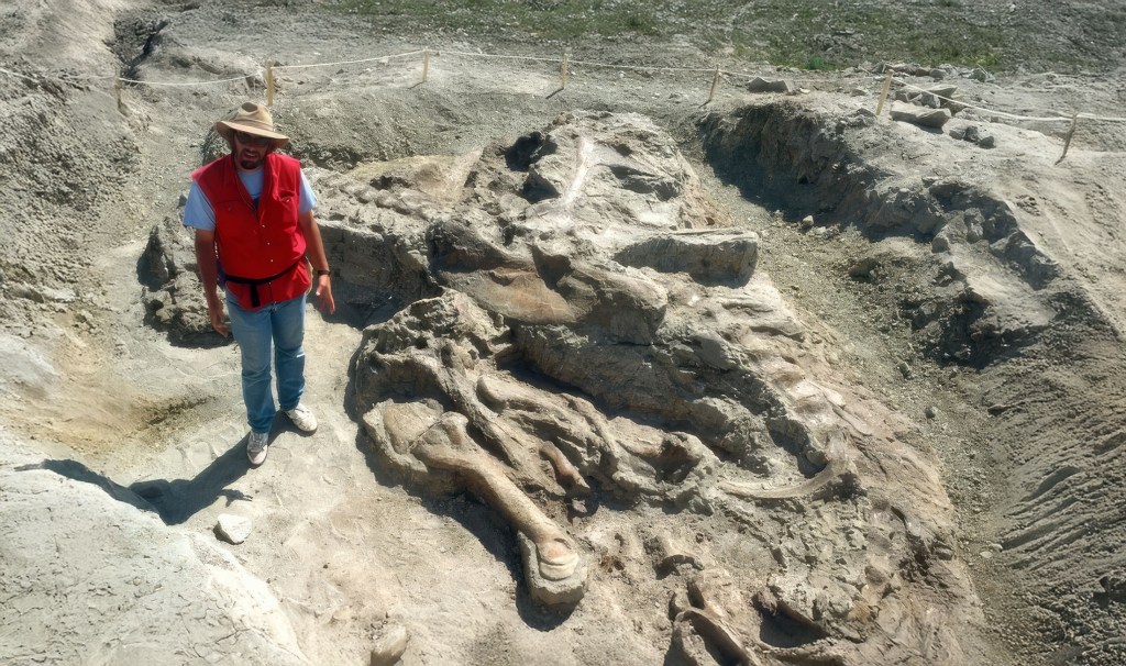
Pinnacles National Park’s open landscape of dramatic rock formations and craggy spires looks otherworldly, especially in golden hour light. But few people who visit the park, located in Central California, southeast of the San Francisco Bay Area, are aware that the rock formations were once at the center of a fierce debate in the history of California geology.  

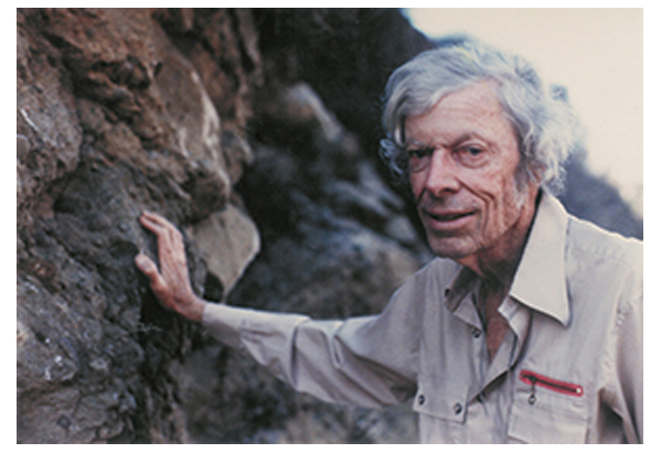
And at the center of the controversy was a young geologist named Thomas Dibblee Jr. 

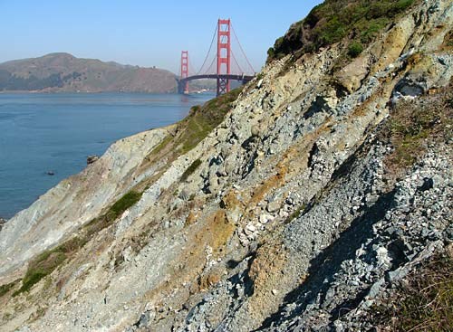
Pinnacles National Park, formerly Pinnacles National Monument, tells the story of ancient volcanic activity and the relentless geologic forces of the San Andreas Fault. This fault, a major boundary between the Pacific and North American tectonic plates, is the platform for the dramatic northward journey of the park’s volcanic remnants. Dibblee’s research illuminated how, over millions of years, the landscapes we see today were sculpted by the movements of these tectonic plates and how the shape of California as a state has changed dramatically as a result.

Thomas Dibblee Jr. (Source: Wikipedia)

The crux of Dibblee’s discovery lies in the relationship between Pinnacles National Park and a volcanic source located near present-day Neenach, close to Palmdale in Southern California. The geological narrative that Dibblee pieced together revealed that the rock formations at Pinnacles originated from volcanic eruptions that occurred approximately 23 million years ago, near what is now Neenach. Over millions of years, the relentless movement along the San Andreas Fault has transported these formations over 195 miles (314 kilometers) to their current location. At the time, very few people, geologists included, believed that was possible.

CALIFORNIA CURATED ON ETSY

Purchase stunning coffee mugs and art prints of iconic California scenes.
Check out our Etsy store.

Dibblee had to be wrong. But it turned out, he was not, and his measurements and discovery launched a passionate debate about the speed of geologic forces.

Dibblee’s findings not only shed light on the significant distances that landscapes can travel over geological timeframes but also provided a tangible connection between the theory of plate tectonics and observable geological features. The juxtaposition of Pinnacles National Park and the Neenach volcanic formation serves as a clear indicator of the San Andreas Fault’s role in shaping California’s geological, indeed it’s physical, identity.

Pinnacles National Park (NPS)

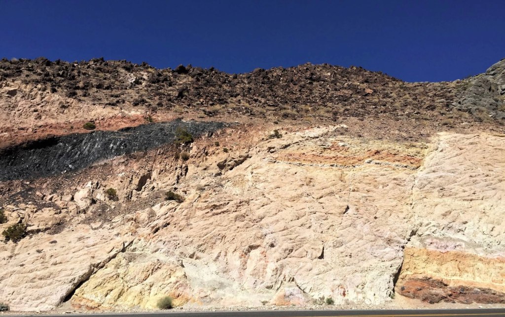
A key aspect of Dibblee’s methodology was his keen observational skills, which enabled him to recognize that the rocks at Pinnacles National Park were strikingly similar in composition and age to those near Neenach, even though these areas are separated by about 195 miles (314 kilometers) today. He noted the volcanic origins of these formations and, through detailed mapping, was able to correlate specific rock types and strata between these distant locations.

Another crucial element in Dibblee’s discovery was his understanding of the San Andreas Fault as a major geological feature capable of significant lateral movement (remember the San Andreas is a slip or sliding fault). By correlating the age and type of rocks across this fault line, Dibblee inferred that the only plausible explanation for the similarity between the rocks at Pinnacles and those near Neenach was that they had once been part of the same volcanic field, which had been split and displaced over millions of years due to the movement of the San Andreas Fault.

Rock formations at Pinnacles National Park (Brocken Inaglory)

Dibblee’s work also benefited from the broader scientific context of his time, particularly the emerging theory of plate tectonics in the mid-20th century. This theoretical framework provided a mechanism for understanding how large-scale movements of the Earth’s crust could result in the displacement of geological formations over vast distances. Dibblee’s findings at Pinnacles and Neenach became a compelling piece of evidence supporting the theory of plate tectonics, showcasing the San Andreas Fault’s role in shaping California’s landscape.

But Dibblee’s ideas were controversial at the time. Many in the scientific community were hesitant to embrace a theory that suggested such dramatic movement across the Earth’s crust, partly because it challenged existing paradigms and partly due to the limitations of the geological evidence available at the time. The prevailing theories favored more static models of the earth’s crust, with changes occurring slowly over immense periods. Dibblee’s insights into tectonic movements and the geological history of regions like the Pinnacles National Park were ahead of their time and laid the groundwork for the acceptance of plate tectonics.

This Pinnacles revelation was groundbreaking, emphasizing the dynamic and ever-changing nature of the Earth’s surface. Dibblee’s ability to piece together these monumental shifts in the Earth’s crust from his detailed maps and observations has left a lasting impact on our understanding of geological processes. His work at Pinnacles and the recognition of its journey alongside the San Andreas Fault underscores the importance of detailed geological mapping in unraveling the Earth’s complex history.

San Andreas Fault looking northwest onto the Carrizo Plain (John Wiley)

Born in 1911 in Santa Barbara, California, Dibblee’s life and work were deeply intertwined with the rugged terrains and picturesque landscapes of the Golden State, Dibblee’s journey into geology began at a young age, fostered by his natural curiosity and the geological richness of his native state.

After earning his degree from Stanford in 1936, Dibblee embarked on his professional journey with Union Oil, later moving to Richfield. It was during this period that his extensive field mapping efforts culminated in the discovery of the Russell Ranch oil field near New Cuyama. By 1952, Dibblee had meticulously mapped every sedimentary basin in California with potential for oil, cementing his legendary status as a petroleum geologist. His reputation for traversing the state’s backcountry on foot for extended weeks became a defining aspect of his character and contributed to his storied career in geology. 

Dibblee moved on to a career at the United States Geological Survey (USGS) that would span over six decades, much of it spent with the agency and then later through independent projects. His work ethic and passion for fieldwork were unparalleled; Dibblee was known for his meticulous and comprehensive approach, often spending long days in the field, mapping out California’s complex strata with precision and care.

Over his career, Dibblee mapped over 240,000 square kilometers of California’s terrain, an achievement that provided an invaluable resource for understanding the state’s geological history and structure. He mapped large swaths of the Mojave Desert, the Coast Range and the Los Padres National Forest, earning a presidential volunteer action award in 1983 from President Reagan.

His maps are celebrated for their accuracy and detail, serving as critical tools for academic research, oil exploration, environmental planning, and education. The Dibblee Geological Foundation, established to honor his work, continues to publish these maps, ensuring that his legacy lives on.

Dibblee Map

Dibblee’s insights into the geology of California were pivotal in several areas, including the understanding of the San Andreas Fault, a major fault line that has been the focus of extensive seismic research due to its potential for large earthquakes. Dibblee’s mapping efforts helped to clarify the fault’s characteristics and behavior, contributing to our understanding of earthquake risks in California and aiding in the development of safer building practices and disaster preparedness strategies.

Furthermore, Dibblee’s work shed light on the process of plate tectonics and the geological history of the western United States. His observations and mapping of sedimentary formations and fault systems in California provided empirical evidence that supported the theory of plate tectonics, a cornerstone of modern geology that explains the movement of the Earth’s lithospheric plates and the formation of various geological features.

Thomas Dibblee Jr.’s contributions to the field of geology are not just confined to his maps and scientific discoveries. He was also a mentor and inspiration to many aspiring geologists, sharing his knowledge and passion for the Earth’s history through lectures, field trips, and personal guidance. His dedication to his work and his ability to convey complex geological concepts in an accessible manner made him a respected figure among his peers and students alike. Through his dedication and pioneering work, Dibblee has left an indelible mark on the field of geology, making him a true giant in the scientific exploration of California as well as our planet.

Roadcut Revelations: Unearthing California’s Deep History Along the Highway

Roadcut in Southern California on Angeles Crest Highway (Photo: Erik Olsen)

“Man is a geologic agent,” the late California geologist Eldridge Moores.

Roadcuts in California, those slices through hills and mountainsides made during the construction of roads, are like open books to geologists. They reveal the intricate and often dramatic geological history of the state. When you drive along the highways of California, you’re likely to pass by these exposed cliffs of rock. To the everyday traveler, they might just be a part of the landscape, but to geologists, they are invaluable windows into the Earth’s past.

““Geologists on the whole are inconsistent drivers. When a roadcut presents itself, they tend to lurch and weave,” wrote the great geology (and many other topics) writer John McPhee in his excellent book Annals of the Former World. “To them, the roadcut is a portal, a fragment of a regional story, a proscenium arch that leads their imaginations into the earth and through the surrounding terrane.”

Glacier carved domes tell the story of thousands of years of glaciation in California. (Photo: Erik Olsen)

Roadcuts expose layers of rock that have been hidden from view for millions of years. Each layer, or stratum, tells a story of what the environment was like when that layer was deposited. By studying these layers, geologists can reconstruct a timeline of events that shaped the region. For example, they can identify periods of volcanic activity, times when the area was submerged under an ancient ocean, or epochs when massive glaciers were carving out the valleys.

California is especially interesting due to its active tectonic setting. It’s not just the San Andreas Fault that captivates geologists; there are numerous lesser-known faults that crisscross the state, and roadcuts can expose these hidden fractures. By studying the composition of rocks along these faults, geologists learn about the nature of past seismic activity and can make predictions about future earthquakes.

The rock composition in California varies widely, offering a rich tapestry of geological history. In the Sierra Nevada, granite roadcuts tell of a time when massive chambers of magma slowly cooled and crystallized deep beneath the Earth’s surface. Elsewhere, roadcuts through sedimentary rocks like sandstone and shale may contain fossils, giving clues about the life forms that once inhabited the region.

The San Gabriel Mountains consist of granite rocks of several kinds and a variety of other crystalline rocks, mainly schists, some of which were originally shales and sandstones but have been altered (metamorphosed) by great igneous intrusions and compression. (Photo: Erik Olsen)

These man-made artifacts also reveal the forces that have shaped California’s diverse landscapes. In roadcuts, geologists might find evidence of powerful geological processes such as metamorphism, where existing rock types are transformed into new types due to high pressure and temperature conditions. For instance, the presence of metamorphic rocks like schist and gneiss can indicate ancient collision zones where Earth’s tectonic plates have crashed together.

The value of California roadcuts is wonderfully illustrated in John McPhee’s “Assembling California.” The book is an excellent narrative that weaves the tale of California’s complex geology with the lives of the geologists who study it. Eldridge Moores, a late prominent geologist from the University of California, Davis (Moores died in 2018), played a significant role in deciphering the geological history of the region, particularly through his fieldwork involving roadcuts.

Roadcut in San Gabriel mountains. (Photo: Erik Olsen)

At the time Eldridge Moores entered the field, the theory of plate tectonics was only beginning to gain traction. In the early 1960s, the idea that continents drifted and that vast slabs of the Earth’s crust moved over the mantle was still controversial, met with skepticism by many geologists trained in older, fixist models. Moores, however, embraced the theory early, recognizing in it an explanation for the chaotic structures he saw in California’s mountain belts. As a young researcher, he studied the Troodos ophiolite in Cyprus, an exposed section of ancient oceanic crust, and realized that similar rock assemblages—serpentinized peridotites, deep-sea sediments, and basaltic lavas—were scattered across California.

“It was a very exciting time. I still get goosebumps even talking about it,” Moores told KQED in 2017. “A turning point, I think it was, in the plate tectonic revolution, that was the watershed of geology.”

With plate tectonics as a guiding framework, Moores understood that these rocks were remnants of vanished oceans, relics of seafloor that had been uplifted and accreted onto the edge of North America. His work helped reveal that much of California had arrived in pieces, a geological patchwork of island arcs, deep-sea basins, and continental fragments welded together by subduction. While others were still debating the validity of plate tectonics, Moores was already applying it, using it to decode the assembly of an entire state.

Eldridge Moores at the Cordelia fault.  (Photo: UC Davis)

Moores was renowned for his work on ophiolites, sections of the ocean floor that have been thrust up onto the continent. One of his notable discoveries was the identification of ophiolite sequences in the roadcuts along the highways of the Sierra Nevada. These discoveries were crucial in understanding the ancient tectonic movements that shaped western North America.

Through roadcuts, Moores and his colleagues were able to observe and study the juxtaposition of different rock types, providing further evidence for the theory of plate tectonics. They could literally walk along the cuts and see how different terranes—large packets of rock with a distinct geological history—were stitched together like a geological quilt, offering insight into the past locations of tectonic plates.

CALIFORNIA CURATED ON ETSY

Purchase stunning coffee mugs and art prints of iconic California species.
Check out our Etsy store.

“Nature is messy,” Moores once told McPhee. “Don’t expect it to be uniform and consistent.”

There are thousands of roadcuts across California, each exposing a fragment of the state’s chaotic geology. The Palmdale Roadcut, a striking geological feature along the San Andreas Fault, has been an invaluable resource for geologists studying the dynamics of this infamous fault line. This natural cut exposes a cross-section of the earth, revealing layers of rock and sediment that have been shifted and shaped by seismic activity over millions of years. The rock here is a chaotic mélange—fault gouge, shattered granite, and twisted layers of sedimentary rock that have been pulverized and ground together by the relentless motion of the Pacific and North American plates. By analyzing these layers, geologists can better understand the history and behavior of the San Andreas Fault, including the patterns of past earthquakes and the movements of tectonic plates. This, in turn, contributes significantly to the broader understanding of seismic risks and aids in preparing for future seismic events.

The Palmdale Road Cut on Hwy 14 in Southern California is a 90-foot slice through swirling sediments that have spent millions of years being squeezed and twisted by the San Andreas fault. Some say that this view of the fault is one of the best in all of California.
(Photo: Erik Olsen)

Another geologist, Garniss Curtis, used California roadcuts to study volcanic rocks and their embedded minerals, which allowed for the dating of geologic events with greater precision. His work on the potassium-argon dating method turned roadcuts into time machines, where the age of rocks could be determined with the help of exposed minerals.

One of California’s most well-known roadcuts, the Charlie Brown Outcrop (map), is a favorite among geologists. Located along Highway 178 near the Nevada border, it has been highlighted by geology teacher Garry Hayes, author of the acclaimed Geotripper blog. Hayes says of the roadcut (also known as the Shoshone Roadcut):

“There are really three stories told in this exposure, that of distant ash eruptions, a violent eruption close by, and earthquakes with associated mountain-building.”

Charlie Brown outcrop along highway 178 in California. (Google Maps)

These geologists, among others, have used roadcuts as a means to peel back the layers of time, revealing the processes that have operated to create the state’s diverse geologic scenery. Roadcuts have provided the evidence for groundbreaking theories and have been instrumental in mapping the geological evolution of California. The work of these scientists exemplifies the roadcut’s role as a natural laboratory, a place where Earth’s geologic history is on full display for those who know how to read the rocks.

Moreover, roadcuts are crucial for educating the next generation of geologists. They serve as natural laboratories where students can practice identifying rock types, deciphering the sequence of geological events, and understanding the dynamic forces that continue to shape the Earth.

Roadcuts in California, those slices through hills and mountainsides made during the construction of roads, are like open books to geologists. They reveal the intricate and often dramatic geological history of the state. (Photo: Erik Olsen)

In Assembling California, McPhee remarked that “geologists are like dermatologists: they study, for the most part, the outermost two per cent of the earth. They crawl around like fleas on the world’s tough hide, exploring every wrinkle and crease, and try to figure out what makes the animal move.”

Manmade creations like roadcuts greatly assist geologists in their work. In essence, roadcuts are not just incidental byproducts of infrastructure development; they are key to understanding California’s complex geological evolution. They tell stories of ancient environments, tectonic upheavals, and the slow but inexorable forces that continue to mold the landscape. For geologists in California, the roadcut is a portal into the deep past, offering a tangible connection to the processes that have made the state what it is today.

Underground Fury: The 1985 Methane Blast That Rocked Los Angeles and Rerouted Its Subways

A 1985 methane explosion in L.A.’s Fairfax district turned a Ross Dress for Less into a disaster scene.
Photo by Dean Musgrove, courtesy of the Herald-Examiner Collection – Los Angeles Public Library.

In the heart of Los Angeles, on a seemingly ordinary spring day in 1985, a sudden explosion tore through the Ross Dress for Less store at the corner of 3rd Street and Fairfax Avenue. This wasn’t an industrial accident nor was it an act of malice—it was a force of nature that had been lurking unseen beneath the city’s streets: methane gas.

The Fairfax District, a bustling area known for its shopping and historic Farmers Market, is also part of the larger Salt Lake Oil Field, a subterranean landscape rich in hydrocarbons. Over millions of years, decaying organic matter trapped in the earth’s crust had transformed into vast reservoirs of oil and methane gas. It was this methane that had stealthily migrated close to the surface, building up in closed spaces, waiting for an ignition source to set off a dramatic release.

On that day, as shoppers browsed through discounted apparel, an explosive mixture of methane, oxygen, and sewer gases found its spark. The blast shattered the storefront windows and caused a partial cave-in of the roof, turning the shop’s interior into a mangled wreck of metal debris. Twenty-three individuals were left with injuries severe enough to necessitate hospital care. In the aftermath, police cordoned off a four-block radius encompassing the bizarre spectacle of gas fires that jetted into the night sky, a haunting tableau that persisted until dawn.

The aftermath of the explosion was a scene of chaos and confusion. Emergency services sprang into action, addressing the immediate humanitarian concerns. But once the dust settled, a more profound issue loomed: the implications for the city’s ambitious underground Metro Rail project.

At the time, Los Angeles was in the throes of planning and constructing the Metro Red Line, a subway system that promised to link various parts of the sprawling city. Wilshire Boulevard, one of the busiest thoroughfares in Los Angeles, was to be a central artery in this new subterranean network. However, the explosion at Ross Dress for Less exposed the heretofore underestimated risk of tunneling through methane-rich zones.

The city of Los Angeles created a methane zone map showing shaded regions of the methane zone and methane buffer zones.

Fears quickly escalated about the potential for similar explosions occurring elsewhere, particularly along the planned subway routes. The public, already wary of the high costs and disruptions associated with the Metro line, grew increasingly concerned about the dangers of tunneling through methane pockets.

In the wake of the explosion, city officials and Metro Rail engineers faced a daunting challenge. They needed to ensure public safety without derailing the critical infrastructure project. This task required a multifaceted approach. First, there was a thorough scientific investigation. Experts from various fields, including geologists, engineers, and safety specialists, were brought in to assess the risks of methane gas in the Fairfax District and along the proposed Metro route.

In a comprehensive regulatory response, the city imposed stringent building codes and established the Methane Zone Ordinance, which required new constructions in certain areas to implement gas detection and venting systems.

But the blast also resulted in a measure of technological innovation. The Metro Rail project incorporated state-of-the-art methane detection systems and emergency ventilation procedures in its design, setting a new standard for subway safety. The process was aided to some extent by significant community engagement. Public meetings and forums were held to address community concerns, offer reassurances, and provide education on the measures being taken to prevent future incidents.

B Line train at Union Station (Wikipedia)

Despite these efforts, the fear of what lay beneath Los Angeles’ streets had a chilling effect on the Metro’s progress. The Red Line faced delays as policymakers and the public grappled with the cost and complexity of making the subway safe. It wasn’t until the early 2000s, with the introduction of advanced tunneling technologies and robust safety protocols, that the Metro expansion regained momentum.

The 1985 methane explosion, while a localized event, reverberated through time to shape the development of Los Angeles in profound ways. It brought to the forefront the invisible risks of urban growth, challenged engineers and city planners to innovate, and ultimately reaffirmed the resilience of a city determined to rise above its subterranean challenges.

1983 rendering for the planned subway station at Wilshire and Fairfax – a casualty of the Ross explosion.
\Courtesy of the Metro Transportation Library and Archive.

The dangers of methane beneath Los Angeles are far from gone. The Porter Ranch leak, also known as the Aliso Canyon gas leak, was a massive methane leak in the Santa Susana Mountains near the neighborhood of Porter Ranch in the northwest section of the San Fernando Valley.. Discovered on October 23, 2015, gas was discovered escaping from a well within the Aliso Canyon underground storage facility. On January 6, 2016, Governor Jerry Brown issued a state of emergency, and numerous media reports suggested that the methane could be dangerous to residents.  On February 11, the gas company reported that it had the leak under control, and finally  on February 18, state officials announced that the leak was permanently plugged. Still, an estimated 97,100 tonnes (95,600 long tons; 107,000 short tons) of methane and 7,300 tonnes (7,200 long tons; 8,000 short tons) of ethane were released into the atmosphere.

Today, as the Los Angeles Metro continues to expand, the lessons learned from that explosive day in 1985 continue to resonate, ensuring that safety remains at the core of the city’s march toward the future.

Hey there! If you enjoy California Curated, consider donating the price of a coffee to support its creation!

Tejon Pass is a Journey Through Time, Terrain, and Tectonics

Interstate 5 coming out of the Grapevine near Tejon Pass (Photo: Erik Olsen)

There’s a drive that I’ve done many times where I tend to look around and wonder about the place. It’s while I’m on I-5 headed north, a while after passing Santa Clarita, Magic Mountain (I always strain to see if there are people on the roller coasters), and the CalArts up on the hill (where so many Pixar legends once trained).

Perhaps you’ve done it, too. Maybe you get gas in Castaic, then you pass Pyramid Lake, and you’ve fully left the San Fernando Valley behind. Then the climb begins and the terrain changes dramatically. It’s subtle at first. The road starts to rise, winding past low ridges covered in golden grass and sun-bleached rock. Then the grade steepens. You see warning signs for trucks: “Turn off A/C to avoid overheating.” Semis tuck into the right lanes, their flashers blinking, straining against gravity. You’re ascending into the Tehachapi Mountains. The name comes from the Southern Paiute word “Tihachipia” meaning “hard climb”, which makes a ton of sense when you’re there. These mountains are part of the geologically fascinating Transverse Ranges, which we’ve written about before. Up ahead is Tejon Pass, the official name for the mountain crossing, but it’s more famously known to most drivers as the Grapevine, the steep stretch of I-5 that descends into the Central Valley.

The highway carves through steep canyon walls and hillsides sometimes bright with flowers, sometimes scarred by past wildfires. If it’s summer, the air gets drier and hotter; in winter, it might be raining or even snowing. You’re crossing one of the most weather-vulnerable stretches of highway in the state. The road is wide but unforgiving. Watch for crosswinds, or the occasional patrol car tucked into a turnout. Tejon Pass is more than just a mountainous pathway connecting the San Joaquin Valley to Los Angeles. It’s a geological and historical hotspot that tells a story of native tribes, daring transportation, seismic activity, and human ingenuity.

The weather can change quickly near Tejon Pass (Photo: Erik Olsen)

Rising to an elevation of 4,160 feet, Tejon Pass’s unique topography is a fascinating blend of rugged mountains, deep canyons, and expansive plateaus. At the summit, the land briefly levels out. There’s a moment where the mountains give you a glimpse in both directions. Behind, the tangled ridges of Southern California. Ahead, a vast, hazy bowl: the southern end of the Central Valley. You pass the Fort Tejon Historical Park turnoff, and suddenly, you’re descending.

The road plunges down in a series of long, controlled curves. Runaway truck ramps cut into the hillside like scars. Then, like stepping through a door, you’re out of the mountains. Flatness stretches to the horizon. Orchards, oil derricks, and cattle fields mark your arrival in the valley. The air feels different. Denser, warmer. You’re in Kern County now, approaching the outskirts of Bakersfield, and the Grapevine is behind you. It’s as if you crossed an invisible line, a border between two Californias.

CALIFORNIA CURATED ART ON ETSY

Purchase stunning coffee mugs and art prints of California icons.
Check out our Etsy store.

Perhaps one of the most captivating aspects of Tejon Pass is its seismic significance. The region is situated at the intersection of two major fault lines: the San Andreas Fault and the Garlock Fault. This combination has made the area a hotspot for seismic activity and has resulted in a number of substantial earthquakes over the years.

Image of the Garlock Fault created with data from NASA’s Shuttle Radar Topography Mission (SRTM)

The most significant of these occurred in 1857, with an estimated magnitude of 7.9. Known as the Fort Tejon earthquake, it caused a rupture along the San Andreas Fault, leaving a lasting imprint on the landscape. Although the area was sparsely populated at the time, the quake’s impacts were far-reaching and could be felt as far as Las Vegas. The event is a reminder of the LA region’s seismic vulnerability, spurring modern research and monitoring to understand and mitigate future risks.

Tejon Pass near Grapevine, California, in 1868

Long before European contact, Tejon Pass was a vital passageway for several Native American tribes, including the Chumash and Tataviam. The area around present-day Gorman, near the pass, was home to the Tataviam village of Kulshra’jek, which functioned as a significant trading crossroads for centuries. These Indigenous communities recognized the strategic importance of the pass, utilizing it for travel, trade, and communication across regions.

With the arrival of European settlers, the pass continued to play a vital role in California’s development. It became one of the state’s oldest continuously used roadside rest stops, a title it still holds today. The pass has borne witness to the evolution of transportation, from horse-drawn carriages to modern highways.

However, not all the tales from Tejon Pass are picturesque. The area has earned the foreboding nickname “Dead Man’s Curve.” This name references a notoriously dangerous curve on the old Ridge Route, infamous for its high number of accidents. The treacherous curve became symbolic of the broader challenges of early automotive travel through the mountains, where both engineering and human limitations were tested.

A section of the 1915 Ridge Route in Lebec, California, known as “deadman’s curve,” was abandoned when the highway was improved over the Tejon Pass. photo by George Garrigues.

The Ridge Route, completed in 1915, was California’s first paved highway directly connecting the Los Angeles Basin with the San Joaquin Valley. Engineered to traverse the challenging terrain of the Sierra Pelona Mountains, it followed a winding path from Castaic to Gorman, culminating at Tejon Pass. This innovative route was a significant milestone in California’s transportation history, facilitating automobile travel between Southern and Central California. ​

A notable segment of this route is known as “The Grapevine,” located in the northern portion descending into the Central Valley. The name originates from the Spanish term “La Cañada de las Uvas,” meaning “The Canyon of the Grapes,” a reference to the wild grapevines that early Spanish explorers, including Don Pedro Fages in 1772, observed growing abundantly in the area.

Over time, the Ridge Route underwent several significant transformations to accommodate increasing traffic and improve safety. In 1933, it was replaced by a three-lane alternate highway, later designated as U.S. Route 99. This was expanded into a four-lane expressway by 1953 . Eventually, the route evolved into the modern eight-lane beast known as the Interstate 5 Freeway, completed in 1970, which continues to serve as a vital artery for transportation in California. You will encounter lots and lots of trucks. ​

Driving Tejon Pass and the Grapevine

Today, Tejon Pass continues to serve as a crucial thoroughfare for Californians and visitors alike, with Interstate 5 traversing the landscape. The Tejon Ranch Conservancy plays a central role in protecting and interpreting this remarkable landscape. Established as part of a landmark 2008 conservation agreement, the Conservancy is tasked with stewarding over 240,000 acres of permanently protected land—making it one of the largest private conservation efforts in California history. Its mission goes beyond preservation; the Conservancy offers guided hikes, wildlife tracking programs, and educational outreach that invite the public to engage directly with the land.

Superbloom near Tejon Ranch (Tejon Ranch Conservancy)

Soon, however, you leave Tejon Pass behind and continue north on I-5, dropping into the southern end of the Central Valley. You pass through the outskirts of Buttonwillow and Lost Hills, where the landscape flattens into a broad, arid plain. It’s mile after mile of industrial agriculture, just endless rows of almonds, pistachios, and oil wells under a hazy sky. The scenery turns monotonous, and although it does have a story (mostly about moving water), it’s one we’ll save for later.

Tejon Pass is one of those places most people barrel through without a second thought. It’s just a steep stretch of I-5 between Los Angeles and the Central Valley, a name on a weather report when the Grapevine closes in winter. But if you take a moment to look beyond the guardrails and gas stations, you’ll find a landscape layered with deep history and surprising complexity. Knowing what lies beneath the pavement won’t make the climb any less steep—but it might make the ride a little more meaningful.

Why Are Dinosaur Fossils So Scarce in California?

Hadrosaur on ancient California landscape. Hadrosaurs like this AI generated one are among the very few dinosaurs whose fossils have ever been found in California.

You’ve surely seen those dramatic museum displays: fearsome T-Rex skulls, triceratops horns, towering brachiosaur skeletons – tangible reminders of a world with giant animals that roamed our planet millions of years ago. Some states are rich in the fossils of ancient dinosaurs. Montana, Wyoming, Utah all have rich fossil records. But not California. Very few dinosaur fossils have ever been found in the Golden State.

But why? We’ve got Hollywood, Silicon Valley, lots of oil, and the Giant Redwoods, but where are our prehistoric dinosaur residents hiding?

To understand this prehistoric puzzle, we have to venture back into the geologic past, and also consider some unique aspects of California’s geographical and geologic evolution.

Dinosaurs were mostly present during the Mesozoic Era, from about 252 million to 66 million years ago. The Mesozoic is divided into three periods: the Triassic, Jurassic, and Cretaceous. The dinosaurs reign likely ended with a massive meteorite impact that caused a mass extinction, wiping out the dinosaurs and up to 80% of life on Earth.

(There’s a cool California story related to this discovery.)

While dinosaur fossils are found around the globe, their distribution is far from even. Fossilization itself is a relatively rare event that depends on several specific conditions. Generally, fossilization requires rapid burial to protect the remains from scavengers and environmental factors, as well as a lack of oxygen to slow down decay. Over time, minerals gradually replace organic material, preserving the structure and creating a fossil, but only a small fraction of organisms ever undergo this process.

Jack Horner, Curator of Paleontology at Museum of the Rockies, provides scale for Tyrannosaurus rex fossils at excavation site near the Fort Peck Reservoir, Fort Peck, Mont., June 1990. (Photo: courtesy Museum of the Rockies

So, when a dinosaur died, its body needed to be quickly covered by sediment, like sand, mud, or volcanic ash. This prevented the remains from being scavenged or decomposed and allowed for the slow process of mineralization, where bones and teeth gradually turn to stone.

Even if these conditions were met, the resulting fossils had to survive millions of years of geologic processes, such as erosion, plate tectonics, and volcanic activity. To find dinosaur fossils today, the layers of rock in which they are embedded must be exposed at the Earth’s surface.

But now here’s where California’s unique geologic history comes into play. Most of the land we see today in California wasn’t even above sea level during the Mesozoic Era, instead it was submerged beneath the Pacific Ocean. Only small, scattered volcanic islands or bits of uplifted crust occasionally broke the surface, shaped by the intense movement of tectonic plates. That means there were no T. rexes or Stegosaurs ambling through Yosemite Valley…which, by the way, hadn’t even formed yet.

California’s active geology works against fossil preservation. The state sits on the boundary of tectonic plates (the Pacific and North American plates), resulting in significant geological activity including earthquakes, volcanic activity, mountain building, and erosion. These processes tend to destroy fossils rather than preserve them.

Head section of Olenellid trilobite in a Latham Shale slab. (Credit: National Park Service)

California, in the form we recognize today, is relatively new land that finally began rising out of the ocean near the end of the dinosaur age, as mountain ranges like the Sierra Nevada started to form and ancient sea basins uplifted. While these earlier conditions weren’t favorable for preserving land-dwelling dinosaur fossils, they did leave behind a rich marine fossil record, including ammonites, marine reptiles, and countless microfossils.

That said, there have been several discoveries of particular animals in California, representing animals much later in the dinosaur story. The majority of the dinosaur fossils found in California are the bones of hadrosaurs, duck-billed dinosaurs that lived during the Late Cretaceous period. These herbivorous dinosaurs thrived in what was once a coastal plain environment, and their remains have been uncovered in parts of California like the Point Loma Formation near San Diego, the Panoche Hills area near Fresno, and in Baja California.

Mosasaur artists rendering (Wikipedia)

While much of California was underwater during the Late Cretaceous, it was home to mosasaurs, large carnivorous marine reptiles that lived in oceans all over the world. These fearsome predators had long, streamlined bodies with powerful fins and jaws lined with sharp teeth. They hunted fish, ammonites, and possibly even other mosasaurs. Some species grew as big as modern whales and ruled the seas at the very end of the dinosaur age. Mosasaurs shared the world with creatures like Triceratops and Tyrannosaurus, but they vanished along with the dinosaurs during the mass extinction at the close of the Cretaceous. Today, paleontologists recognize mosasaur fossils by distinctive features on their skeletons, including unique muscle attachment scars and specialized bone knobs.

CALIFORNIA CURATED ART ON ETSY

Purchase stunning art prints of iconic California scenes.
Check out our Etsy store.

Back to hadrosaurs, however. There is the duck-billed plant-eater Augustynolophus, a member of the hadrosaur family, which recently was named the official state dinosaur of California. All known specimens of Augustynolophus have been found only in California, in particular the Moreno Formation in the San Joaquin Valley. Only two specimens have ever been found. The first fossil was uncovered in Fresno County in 1939. The second was discovered nearby in 1941 in San Benito County, according to the Natural History Museum of Los Angeles County website. Named after paleontologist William J. Morris and NHMLA patron Gretchen AugustynAugustynolophus remains one of few dinosaurs that have been discovered in the state.

Artists recreation of the hadrosaur Augustynolophus by the Natural History Museum of Los Angeles County

As mentioned above, the action of plate tectonics, the slow but powerful movements of sections of the Earth’s crust, has significantly affected California’s fossil record. Over millions of years, California has been built from pieces of the Earth’s crust that traveled here aboard tectonic plates.

Much of the rock we see at the surface today, especially along the coast and in the western mountains, arrived during the Cenozoic Era, after the age of dinosaurs. These younger rocks, while not bearing dinosaur fossils, have yielded rich caches of mammal fossils, including creatures like saber-toothed cats, mammoths, and dire wolves, which roamed California long after the dinosaurs.

In recent years, paleontologists have begun to find more dinosaur fossils in California, albeit still far fewer than in states like Utah, Montana, or Wyoming. These discoveries, often of marine animals or those who lived near the coast, are expanding our understanding the ancient Californian landscape.

Saber-toothed cat (State of California Capitol Museum)

In 2022, a remarkable fossil discovery was made during a construction project at San Pedro High School in Los Angeles. The excavation revealed a massive trove of marine fossils from the Miocene Epoch, dating back around 5 to 23 million years (so, not technically dinosaur fossils). Among the finds were the remains of ancient whales, sharks, fish, and mollusks, offering a rare glimpse into Southern California’s prehistoric past when the region was submerged under a warm, shallow sea. This discovery provided paleontologists with valuable insights into the marine ecosystems that once thrived in the area.

Among the fossils found under San Pedro High School are juvenile megalodon teeth, right, the great white shark’s ancestor; those from mako sharks, center; and from smaller sharks.
 (Wayne Bischoff / Envicom Corp.)

In addition to the marine fossils, a few terrestrial remains were also uncovered, hinting at a nearby coastline that once supported a variety of land animals. The discovery of such well-preserved fossils captured the attention of scientists and the local community alike, briefly turning the San Pedro High School campus into an unexpected center of scientific excitement. For students and residents, the find offered a cool reminder of the ancient worlds buried just beneath their everyday lives.

While California’s record of dinosaur fossils is relatively sparse, its mammal fossil record is nothing short of astonishing. Sites like the La Brea Tar Pits in Los Angeles preserve an incredible array of Ice Age mammals, from saber-toothed cats and mammoths to giant ground sloths. These fossils provide an unparalleled window into the vibrant ecosystems that thrived long after the age of dinosaurs ended, showcasing California’s rich and varied prehistoric past.

saber toothed cat
Saber-toothed cat fossil skeleton at the La Brea Tar Pits in Los Angeles (Photo: Erik Olsen)

While it might be tempting to feel a little disappointed that California doesn’t have an abundance of dinosaur fossils, that’s simply the way the landscape evolved. But there’s still plenty to celebrate. California’s unique geologic past has produced a vibrant fossil record of other ancient life — from towering prehistoric sequoias to tiny, long-lost plankton. Every fossil, big or small, offers a glimpse into the rich, complicated, and ever-changing story of this remarkable place we call California.

Serpentine is the Geological Gem of California

Serpentine (Wikipedia)

Ask anyone what the California state rock is, and I doubt whether many people would answer correctly. Is it granite, the magnificent slabby stone that creates the sheer face of Half Dome and El Capitan in Yosemite? Is it obsidian, the glinty black stone so favored by some Native American tribes that they would walk hundreds of miles to collect it and bring home to make tools and weapons?

No, the state rock of California is neither of these. The state rock of California is serpentine.

Serpentine is more than just a pretty rock—it tells a fascinating geological story. Found in many parts of California, particularly in the Coast Ranges and the Sierra Nevada foothills, serpentine is a direct link to the deep, dynamic forces that shape the planet. Because it originates from the mantle, serpentine represents a rare glimpse into Earth’s interior, a reminder that what lies beneath us is always in motion. Beyond its aesthetic appeal, serpentine plays an important role in the environment. The soils that develop from serpentine rock are famously inhospitable to many plants due to their high levels of magnesium and low levels of essential nutrients like calcium. Yet, these tough conditions have led to the evolution of specialized plants—some of which are found nowhere else on Earth. California’s serpentine landscapes, with their sparse but highly adapted plant life, are home to unique ecological communities that have fascinated scientists for decades.

serpentine
A piece of polished serpentine reveals its beauty. (gemstones.com)

Serpentine is formed through the metamorphic process, where pre-existing rocks are transformed into new types under high temperatures, pressures, and chemical processes. Serpentine is primarily composed of hydrous magnesium silicate minerals, such as antigorite, chrysotile, and lizardite (yes, lizardite). Its distinct, vibrant green color and serpent-like appearance make it easily recognizable and intriguing to rock enthusiasts and casual observers alike. It is also widely collected and used as jewelry.

Serpentine is predominantly found in the coastal ranges of California, particularly in the Klamath Mountains and the Sierra Nevada foothills. It is also present in smaller quantities throughout the state. The prevalence of Serpentine in California is a result of the state’s complex geological history, which includes the subduction of oceanic plates beneath the continental North American Plate. This tectonic activity created ideal conditions for the formation of Serpentine. The recognition and study of serpentine in California contributed to the understanding of modern plate tectonic theory.

Serpentine (Wikipedia)

While not considered a precious gemstone, Serpentine holds significant value due to its unique aesthetic and limited distribution. It is often used as an ornamental stone for jewelry, sculptures, and architectural elements. In addition, Serpentine is historically known for its use in carving, particularly by Native American tribes in California. Serpentine’s low hardness and smooth texture make it ideal for intricate carvings and designs. In recent years, Serpentine has gained popularity among collectors and as a decorative addition to gardens and landscaping.

Serpentine was designated as California’s state rock in 1965, thanks to the efforts of state Assemblyman John Knox. This choice was influenced by the rock’s unique beauty, the significant role it played in California’s geological history, and its importance in the state’s mining industry during the late 19th and early 20th centuries. Asbestos, a fibrous mineral found in some forms of Serpentine, was once highly sought after for its heat-resistant properties. However, due to its association with health risks (asbestos is a known carcinogen that has long been associated with lung cancer), the use of asbestos has significantly declined, and current appreciation of Serpentine is largely focused on its aesthetic qualities.

Serpentinite outcrop on the coastal bluffs of the Presidio (National Park Service)

However, the state almost dropped serpentine from its state rock designation due to the high relative quantity of asbestos that serpentine contains. Asbestos occurs naturally in many minerals and in many places. And in fact some serpentine rocks do host chrysotile, a form of asbestos. But geologists say chrysotile is less harmful than some other forms of asbestos and would be a danger — like scores of other rocks — only if a person were to breathe its dust repeatedly.

Fascinatingly, serpentine landscapes host a rare and diverse range of plant species adapted to its high magnesium and low calcium environment, often thriving in soils toxic to other vegetation. This peculiar combination of geology and ecology makes California’s serpentine areas not just a subject of geological interest, but also a haven for biological research, offering insights into how life adapts to extreme conditions.

One well-studied group of organisms are plants that display serpentine endemism, meaning they are specially adapted to survive in these harsh soils. A key adaptation in plants involves tolerating high levels of toxic metals and nutrient deficiencies, which can drive speciation and lead to unique ecological communities. Studies on species like Arabidopsis arenosa have shown that genetic variation plays a crucial role in these adaptations, with gene flow and mutations contributing to their survival strategies in serpentine soils​.

Serpentine rock (Wikipedia)

Native Americans in California found a variety of practical and cultural uses for serpentine, a mineral abundant in the state and prized for its unique properties. It was particularly valued for its distinctive greenish color, soft texture, and ability to be easily shaped and polished. These qualities made it a favored material for crafting tools, ornaments, and ceremonial objects. Tribes used serpentine to create beads, pendants, and pipes, all of which could be intricately carved and polished to a smooth finish.

In addition to its practical uses, serpentine held significant spiritual and healing value for some Native American groups. The rock’s cool, smooth surface and striking color were believed to possess special properties, and it was often used in rituals or as a symbol of protection and healing. The association with spiritual energy likely contributed to its use in ceremonies or as amulets meant to bring good fortune or ward off harm.

Serpentine stones available for purchase on Ebay (Ebay)

Serpentine also played a role in trade among tribes. Crafted serpentine objects, such as polished ornaments and ceremonial items, were valuable trade goods. These items could be exchanged for other resources, reflecting the mineral’s cultural and economic importance. The widespread availability of serpentine in California’s unique geological landscape made it an accessible yet valuable material for Native American communities, shaping both their daily lives and spiritual practices.

Serpentine is not just a beautiful rock; it is a symbol of California’s rich geological and cultural heritage. By understanding the origins and significance of Serpentine, we can appreciate the complex processes that have shaped our planet and the remarkable diversity of its natural resources. Furthermore, the presence of Serpentine in California is an excellent example of the interconnectedness of geology, ecology, and human history, as the unique habitats it creates support rare plant species and have inspired the artistic endeavors of numerous cultures throughout time.

The Rich Historical and Geological Past of the Alabama Hills

Mobius Arch in Alabama Hills. Lone Pine, California
The Mobius Arch in the Alabama Hills in California (Erik Olsen)

The drive from Los Angeles north along Highway 395 towards Mammoth Lakes is one of the great road trips in all of California. The drive offers breathtaking views of the Sierra Nevada mountain range, the (much older) White Mountains, the vibrantly picturesque Owens Valley, and the Mojave Desert (which, let’s face it, is kinda boring, especially if you’ve done the drive as many times as I have). The highway winds its way through a diverse range of geological and historical features, making it an ideal destination for road trippers, history buffs, and outdoor enthusiasts alike.

One of the highway’s more magnificent sights is observable when making a left turn up Whitney Portal Road in Lone Pine. Just a few miles up, you will find the magnificent Alabama Hills, a range of hills located in the Owens Valley near the main entrance to Mount Whitney. The hills are known for their unique geological formations, including massive rounded boulders and natural arches, and their rich history and cultural significance.

Scene from Iron Man with Robert Downey Jr. The Alabama Hills stood in for Afghanistan.

The hills are world famous not just for their scenic beauty and appeal to photographers. They have also appeared in more than 700 movie and television productions, including some of the most famous and iconic Westerns ever made. The first film made there was the silent 1920 western “The Round Up,” starring Roscoe “Fatty” Arbuckle.

More recently, several major films made use of the Alabama Hills as exotic backdrops. In addition to Iron Man (2008), where Tony Stark crash-lands after escaping captivity, and Gladiator (2000), where the rugged landscape serves as part of the journey for Maximus, the Alabama Hills has also appeared in:

The Lone Ranger (2013) – The dramatic landscape contributes to the film’s adventurous, untamed feel.

Django Unchained (2012) – Here, the rocky outcrops stand in for the American West, giving a distinctive backdrop to Quentin Tarantino’s Western.

Tremors (1990) – The Hills’ remote, desolate look is a perfect setting for this cult classic monster movie.

Star Trek V: The Final Frontier (1989) – Alabama Hills doubles as alien terrain in this installment of the sci-fi series.

CALIFORNIA CURATED ON ETSY

Purchase stunning art prints of iconic California scenes.
Check out our Etsy store.

Other earlier films include:

  • “Gunga Din” (1939)
  • “Rio Bravo” (1959)
  • “How the West Was Won” (1962)
  • “The Lone Ranger” (1956-1957 TV series)
  • “Gunsmoke” (1955-1975 TV series)
  • “The Great Train Robbery” (1903, silent film)

A very nice explanation (with lots of visuals) of the area’s Hollywood past can be seen at the Museum of Western Film History in Lone Pine.

Alabama Hills (Erik Olsen)

Geologically, the Alabama Hills are primarily made up of biotite monzogranite, an intrusive igneous rock, rather than metamorphic rock. This type of granite was formed from magma that cooled slowly beneath the Earth’s surface, allowing large crystals of quartz, feldspar, and biotite to develop. The landscape, featuring spherical, egg-shaped, teardrop forms, and natural arches, was sculpted over millions of years through a combination of chemical weathering and wind erosion.

California barrel cactus or desert barrel cactus Ferocactus cylindraceus at the Alabama Hills (Erik Olsen)

One of the most striking aspects of the Alabama Hills is the sharp contrast they present with the neighboring glacially carved ridges of the Sierra Nevada. There are almost 10,000 feet of vertical difference between Mount Whitney’s majestic granite peaks and the rolling boulders of the Alabama Hills. The Sierra’s jagged, ice-carved peaks seem to rise abruptly from the gentle, rounded contours of the hills. Geologically, both landforms consist of the same granitic rock, but they have been shaped by very different forces. While glaciers carved the high peaks of the Sierra Nevada, creating sharp ridges and deep valleys, the Alabama Hills experienced a slower, more gradual transformation. Erosion by wind, rain, and temperature changes slowly sculpted the monzogranite, creating the unique and surreal formations we see today.

While the geological history of the Alabama Hills is well known, its biology is equally fascinating. At first glance, the landscape may seem inhospitable to life, but a closer inspection reveals a surprisingly diverse ecosystem adapted to the harsh conditions. In recent years, new studies have shed light on the resilience and adaptation strategies of plants and animals in this region.

The Alabama Hills are home to a variety of plant species, many of which have evolved to survive in the dry, rocky soil. Sagebrush, saltbush, and other desert plants dominate the landscape, while prickly cacti add a distinct desert charm. One particularly intriguing plant is Atriplex hymenelytra, commonly known as desert holly, which has adapted to the high-salinity soil by developing silvery leaves that reflect sunlight, reducing water loss and protecting the plant from extreme temperatures.

Atriplex hymenelytra, Desert holly.

Wildlife, too, has found ways to thrive in this rugged terrain. The Alabama Hills are home to numerous bird species, reptiles, and small mammals. Species like the western fence lizard, desert cottontail, and even mountain lions are part of this surprisingly vibrant ecosystem. Birdwatchers can often spot red-tailed hawks, ravens, and sometimes even golden eagles soaring above the hills, taking advantage of the thermal updrafts created by the warm rock surfaces.

Recent studies have added to our understanding of the Alabama Hills’ unique environment. One particularly interesting research project conducted by ecologists focuses on the role of cryptobiotic soil crusts—thin layers of lichens, mosses, and bacteria that live on the surface of desert soils. These crusts play a critical role in preventing erosion and retaining moisture in arid environments like the Alabama Hills. The study revealed that these soil crusts are more widespread than previously thought, and their destruction by human activity, such as off-road vehicle use, could have significant ecological consequences.

Alabama Hills vegetation (Erik Olsen)

Cryptobiotic crusts act as a protective cover on desert soils, anchoring loose particles and reducing susceptibility to wind and water erosion. When these crusts are damaged, the soil is left vulnerable to erosion, which can lead to large-scale soil loss. This erosion depletes the land of nutrients, reduces soil fertility, and diminishes its ability to support native vegetation.

Additionally, geologists continue to study the impact of erosion and weathering on the Alabama Hills’ distinctive rock formations. Advances in remote sensing technology have allowed scientists to map the region’s geological features in more detail than ever before, providing new insights into how these formations developed and how they are likely to change in the future.

The hills were (controversially) named after the CSS Alabama, a Confederate warship that operated during the American Civil War. The name was given to the hills by a group of Confederate sympathizers who were prospecting in the area in the 1860s. Several groups have launched campaigns to change the name to erase its connection with Southern slavery.

Alabama Hills (Erik Olsen)

In addition to their geological and historical importance, the Alabama Hills are also important for their recreational opportunities. The hills offer a variety of outdoor activities such as hiking, rock climbing, and photography. The range of hills is also a popular spot for stargazers and astro-photographers, due to the relatively low light pollution in the region.

The Alabama Hills are a must-see destination for anyone interested in geology, history, or outdoor activities in California.