In California’s southeastern desert, the Salton Sea stretches across a wide, shimmering basin, a lake where there shouldn’t be one. At about 340 square miles, it’s the state’s largest lake. But it wasn’t created by natural forces. It was the result of a major engineering failure. I’ve long been fascinated with the place: its contradictions, its strangeness, its collision of nature and human ambition. It reflects so many of California’s tensions: water and drought, industry and wilderness, beauty and decay. And it was only relatively recently that I came to understand not just how the Salton Sea came to exist, but how remarkable the region’s geological past really is, and how it could play a major role in the country’s sustainable energy future.
In the early 1900s, the Imperial Valley was seen as promising farmland: its deep, silty soil ideal for agriculture, but the land was arid and desperately needed irrigation. To bring water from the Colorado River, engineers created the Imperial Canal, a massive infrastructure project meant to transform the desert into productive farmland. But the job was rushed. The canal had to pass through the Mexican border and loop back into California, and much of it ran through highly erodible soil. Maintenance was difficult, and by 1904, silt and sediment had clogged portions of the canal.
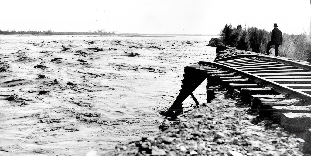
The Southern Pacific Railroad was forced to move it lines several times as the raging, unleashed Colorado River expanded the Salton Sea. (Credit: Imperial Irrigation District)
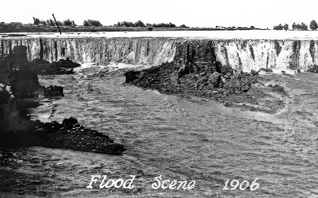
To keep water flowing, engineers hastily dug a temporary bypass channel south of the clogged area, hoping it would only be used for a few months. But they failed to build proper headgates, critical structures for controlling water flow. In 1905, an unusually heavy season of rain and snowmelt in the Rockies caused the Colorado River to swell. The torrent surged downriver and overwhelmed the temporary channel, carving it wider and deeper. Before long, the river completely abandoned its natural course and began flowing unchecked into the Salton Sink, an ancient, dry lakebed that had once held water during wetter epochs but had long since evaporated. (This has happened many times over in the region’s history).
For nearly two years, the Colorado River flowed uncontrolled into this depression, creating what is now known as the Salton Sea. Efforts to redirect the river back to its original course involved a frantic, expensive engineering campaign that included the Southern Pacific Railroad and U.S. government assistance. The breach wasn’t fully sealed until early 1907. By then, the sea had already formed: a shimmering, accidental lake nearly 35 miles long and 15 miles wide, with no natural outlet, in the middle of the California desert.
In the 1950s and early ’60s, the Salton Sea was a glamorous desert escape, drawing crowds with boating, fishing, and waterskiing. Resorts popped up along the shore, and celebrities like Frank Sinatra, Jerry Lewis, Rock Hudson, the Beach Boys, and the Marx Brothers came to visit and perform. It was billed as a new Palm Springs with water, until rising salinity and environmental decline ended the dream. There have been few if any similarly starge ecological accidents like it.
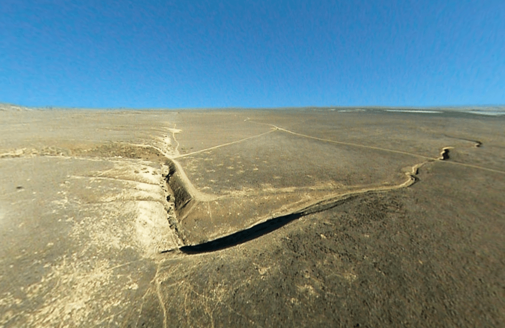
The erosive power of the floodwaters was immense. The river repeatedly scoured channels that created waterfalls, which cut back through the ground, eroding soil at a rate of about 1,200 meters per day and carving gorges 15 to 25 meters deep and more than 300 meters wide. (Credit: Imperial Irrigation District)
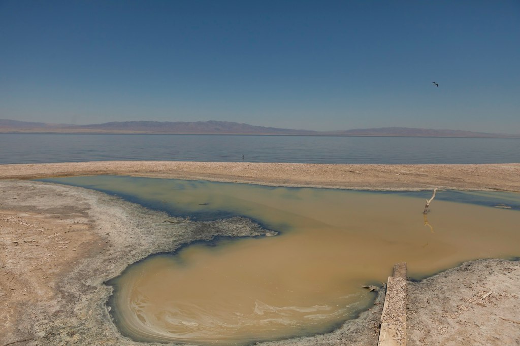
The creation of the Salton Sea was both a blessing and a curse for the people of the Imperial Valley. On the one hand, the lake provided a new source of water for irrigation, and the fertile soil around its shores proved ideal for growing crops. On the other hand, the water was highly saline, and the lake became increasingly polluted over time, posing a threat to both human health and the environment.
Recently, with most flows diverted from the Salton Sea for irrigation, it has begun to dry up and is now considered a major health hazard, as toxic dust is whipped up by heavy winds in the area. The disappearance of the Salton sea has also been killing off fish species that attract migratory birds.
The New York Times recently wrote about the struggles that farmers face as the Salton Sea disappears, and how the sea itself will likely disappear entirely at some point.
“There’s going to be collateral damage everywhere,” Frank Ruiz, a program director with California Audubon, told the Times. “Less water coming to the farmers, less water coming into the Salton Sea. That’s just the pure math.”
Salton Sea can be beautiful, if toxic (Photo: Wikipedia)
To me, the story of the Salton Sea is fascinating: a vivid example of how human intervention can radically reshape the environment. Of course, there are countless cases of humans altering the natural world, but this one feels particularly surreal: an enormous inland lake created entirely by accident, simply because a river, the Colorado, one of the most powerful in North America, was diverted from its course. It’s incredible, and incredibly strange. What makes the region even more fascinating, though, is that the human-made lake sits in a landscape already full of geological drama.
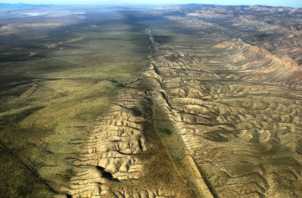
The area around the Salton Sea is located in a techtonically active region, with the San Andreas Fault running directly through it. The San Andreas Fault is a major plate boundary, where the Pacific Plate is moving north relative to the North American Plate (see our story about how fast it’s moving here). As pretty much every Californian knows, the legendary fault is responsible for the earthquakes and other tectonic activity across much of California.
If you look at a map of the area, you can see how the low lying southern portion of the Salton Sea basin goes directly into the Gulf of California. Over millions of years, the desert basin has been flooded numerous times throughout history by what is now the Gulf of California. As the fault system cuts through the region, the Pacific Plate is slowly sliding northwest, gradually pulling the Baja Peninsula away from mainland Mexico. Over millions of years, this tectonic motion is stretching and thinning the crust beneath the Imperial Valley and Salton Basin. If the process continues, geologists believe the area could eventually flood again, forming a vast inland sea, perhaps even making an island out of what is today Baja California. (We wrote about this earlier.)
Entrance to the Salton Sea Recreation Area (Wikipedia)
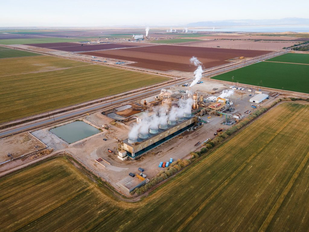
Yet even as the land shifts beneath it, the Salton Sea’s future may be shaped not just by geology, but by energy. Despite the ongoing controversy over the evaporating water body, the Salton Sea may play a crucial role in California’s renewable energy future. The region sits atop the Imperial Valley’s geothermal hotspot, where underground heat from all that tectonic activity creates ideal conditions for producing clean, reliable energy. Already home to one of the largest geothermal fields in the country, the area is now gaining attention for something even more strategic: lithium.
An aerial view of geothermal power plants among the farmland around the southern shore of the Salton Sea. (Credit: Courtesy Lawrence Berkeley National Lab)
Beneath the surface, the hot, mineral-rich brine used in geothermal energy production contains high concentrations of lithium, a critical component in electric vehicle batteries. Known as “Lithium Valley,” the Salton Sea region has become the focus of several ambitious extraction projects aiming to tap into this resource without the large environmental footprint of traditional lithium mining. Gov. Gavin Newsom called the area is “the Saudi Arabia of lithium.” Even the Los Angeles Times has weighed in, claiming that “California’s Imperial Valley will be a major player in the clean energy transition.”
Companies like Controlled Thermal Resources (CTR) and EnergySource are developing direct lithium extraction (DLE) technologies that pull lithium from brine as part of their geothermal operations. The promise is a closed-loop system that produces both renewable energy and battery-grade lithium on the same site. If it proves viable, the Salton Sea could significantly reduce U.S. dependence on foreign lithium and cement California’s role in the global shift to clean energy. That’s a big if…and one we’ll be exploring in depth in future articles.
Toxic salt ponds along the Western shoreline (Photo: EmpireFootage)
Such projects could also potentially provide significant economic investment in the region and help power California’s green energy ambitions. So for a place that looks kind of wrecked and desolate, there actually a lot going on. We promise to keep an eye on what happens. Stay tuned.
Before the late 1960s, understanding Earth’s shifting surface, particularly in a geologically active region like California, was a major scientific challenge. For most of human history, the causes of earthquakes remained an enigma—mysterious and terrifying, often attributed to supernatural forces. In Japan, for example, earthquakes were traditionally believed to be caused by Namazu, a giant catfish said to live beneath the earth and whose thrashing would shake the land. Many societies believed earthquakes were divine punishments or omens, while others considered them an essential part of creation, events necessary to form a world habitable by us humans.
The complexity of California’s landscape, its mountains, valleys, deserts, and intricate network of faults, posed difficulties for early geologists. The land appeared chaotically interwoven, with many different types of rock making up the gaping deserts and soaring peaks. As the great University of California at Davis geologist Eldridge Moores once put it, “Nature is messy. Don’t expect it to be uniform and consistent.”
An image of humans battling a Namazu (Credit: Tokyo University Library. Public Domain)
But there was no overarching explanation for how these earthly features got there. Scientists could observe and record earthquakes, but without a unifying theory, they struggled to piece together the deeper mechanisms driving these powerful events.
This frustration lingered until the late 1960s when an intellectual revolution in geology took shape. Despite the dawn of the space age and the rise of computing power, many earth scientists still clung to the belief that the continents were fixed, immovable features on the Earth’s surface. The breakthrough came with the acceptance of plate tectonics—a theory that elegantly explained not just earthquakes, but the entire dynamic nature of Earth’s surface. And for many geologists, the moment this new understanding solidified was in December 1969, at a groundbreaking conference at the Asilomar Conference Center in California that reshaped the future of the field. (Notably, Asilomar was also the site of the historic 1975 conference on recombinant DNA, where scientists gathered to establish ethical guidelines for genetic research, an event we have explored previously.) This was the moment when plate tectonics, a concept that would fundamentally reshape our view of the planet, truly took hold in the Western American geological community.
At California’s Asilomar Conference Grounds, nestled amid Monterey pines and dramatic granite formations, scientists gathered to rewrite our understanding of tectonics—and reshape how we think about Earth’s restless surface. (Erik Olsen)
For centuries, explanations for Earth’s features ranged from catastrophic events to gradual uplift and erosion, a debate that became known as uniformitarianism versus catastrophism. In California, the sheer complexity of the geology, with its links go far beyond the borders of the state, hinted at powerful forces at play. Scientists grappled with the origins of the Sierra Nevada, the formation of the Central Valley, and the persistent threat of earthquakes along the now-famous San Andreas Fault. The prevailing models, however, lacked the comprehensive framework to connect these disparate observations into a coherent narrative.
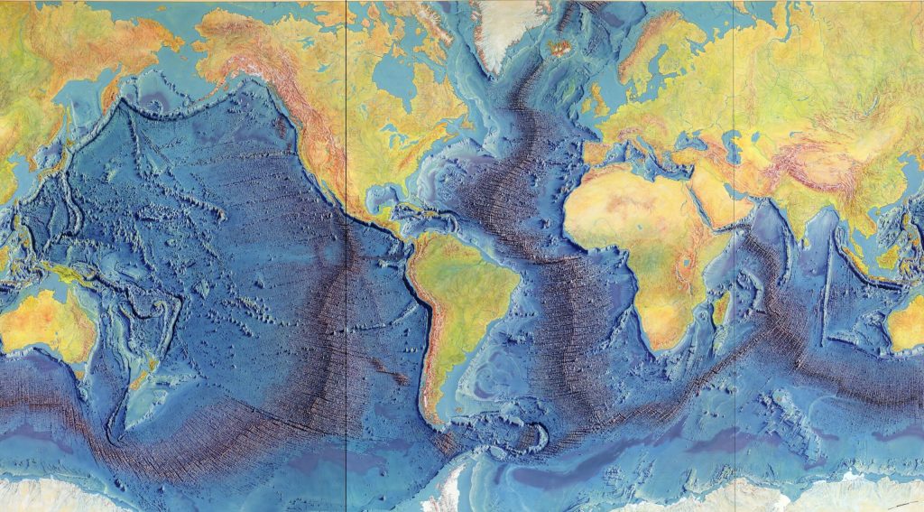
The seeds of the plate tectonic revolution had been sown earlier in the 20th century with Alfred Wegener’s theory of continental drift. Anyone looking at a world map or globe could see how the coastlines of certain continents, particularly South America and Africa, seemed to fit together like pieces of a puzzle, suggesting they were once joined. Wegener proposed that the continents were once joined together in a supercontinent called Pangaea and had gradually drifted apart over millions of years. While his ideas were initially met with skepticism, particularly regarding the mechanism that could drive such massive movements, compelling evidence from paleontology, glacial geology, and the jigsaw-like fit of continental coastlines slowly began to sway opinions. The discovery of seafloor spreading in the 1960s (itself a great story, featuring the brilliant geologist and cartographer Marie Tharp) which revealed that new oceanic crust was constantly being generated at mid-ocean ridges and that the ocean floor itself was moving like a conveyor belt, provided the crucial mechanism Wegener lacked.
Heinrich Berann’s 1977 painting of the Heezen-Tharp “World Ocean Floor” map, a landmark in cartography that showed how the earths plates in some areas are pulling apart while others collide. (Library of Congress)
It was against this backdrop of burgeoning evidence that the Geological Society of America convened one of its annual Penrose Conferences in December 1969 at the Asilomar Conference Center in Pacific Grove, California. Titled “The Meaning of the New Global Tectonics,” the event drew structural geologists from all over the world. The geological world changed overnight. A key figure in the conference was William R. Dickinson, a leading structural geologist whose work helped bridge the gap between traditional geological interpretations and the emerging plate tectonic framework. Dickinson’s research on sedimentary basins and tectonic evolution provided critical insights into how plate movements shaped the western United States, further solidifying the new theory’s acceptance.
These conferences were designed to be intimate gatherings where geologists could engage in focused discussions on cutting-edge research. The 1969 meeting proved to be a pivotal one. As UC Davis’ Moores, then a youthful figure who would become a leading voice of the “New Geology” in the West, later wrote, “the full import of the plate tectonic revolution burst on the participants like a dam failure”.
The Palmdale Road Cut on Hwy 14 in Southern California is a 90-foot slice through swirling sediments that have spent millions of years being squeezed and twisted by the San Andreas fault. Some say that this view of the fault is one of the best in all of California. (Photo: Erik Olsen)
Paper after paper presented at the conference demonstrated how the seemingly simple notion of large plates floating atop the Earth’s plastic mantle (the asthenosphere) could explain a vast array of geological phenomena. The location of volcanoes, the folding of mountains (orogeny), the distribution of earthquakes, the shape of the continents, and the history of the oceans all suddenly found a compelling and unified explanation within the framework of plate tectonics. Geologist John Tuzo Wilson famously referred to plate tectonics as ‘the dance of the continents,’ a phrase that captured the excitement and transformative nature of this intellectual breakthrough.
For Moores, the conference was a moment of profound realization. “It was a very exciting time. I still get goosebumps even talking about it,” he told the writer John McPhee. “A turning point, I think it was, in the plate tectonic revolution, that was the watershed of geology.” Moores had been contemplating the perplexing presence of ophiolite sequences – distinctive rock assemblages consisting of serpentines, gabbro/lava, and sediments – found high in the mountains of the West, including California. He suddenly grasped that these strange and “exotic” rock sequences were remnants of ancient ocean floors that had been lifted on top of the continent through the collision of tectonic plates.
Asilomar Conference Grounds Interior (Erik Olsen)
Moores reasoned that the serpentines and coarsely crystalline igneous rocks at the base of these sequences were characteristic of the rocks underlying all the world’s oceans. The “green rocks” in the middle (now the state rock of California) showed evidence of moderate pressure and temperatures, indicating they had been subjected to significant geological forces. By connecting these ophiolite sequences to the processes of plate collision and obduction (where one plate rides over another), Moores provided a powerful piece of evidence for plate tectonics and offered a new lens through which to understand the complex geological architecture of the American West.
His deduction was in line with what is now known about plate tectonics. The geological “confusion” apparent in the Rockies, the Sierra Nevada, and other western mountain chains was now understood as the result of neighboring plates bumping into each other repeatedly over vast geological timescales. The concept of terranes, foreign rock slabs or slices or sequences that have traveled vast distances and become accreted to continents, further illustrated the dynamic and assembly-like nature of California’s geological landscape.
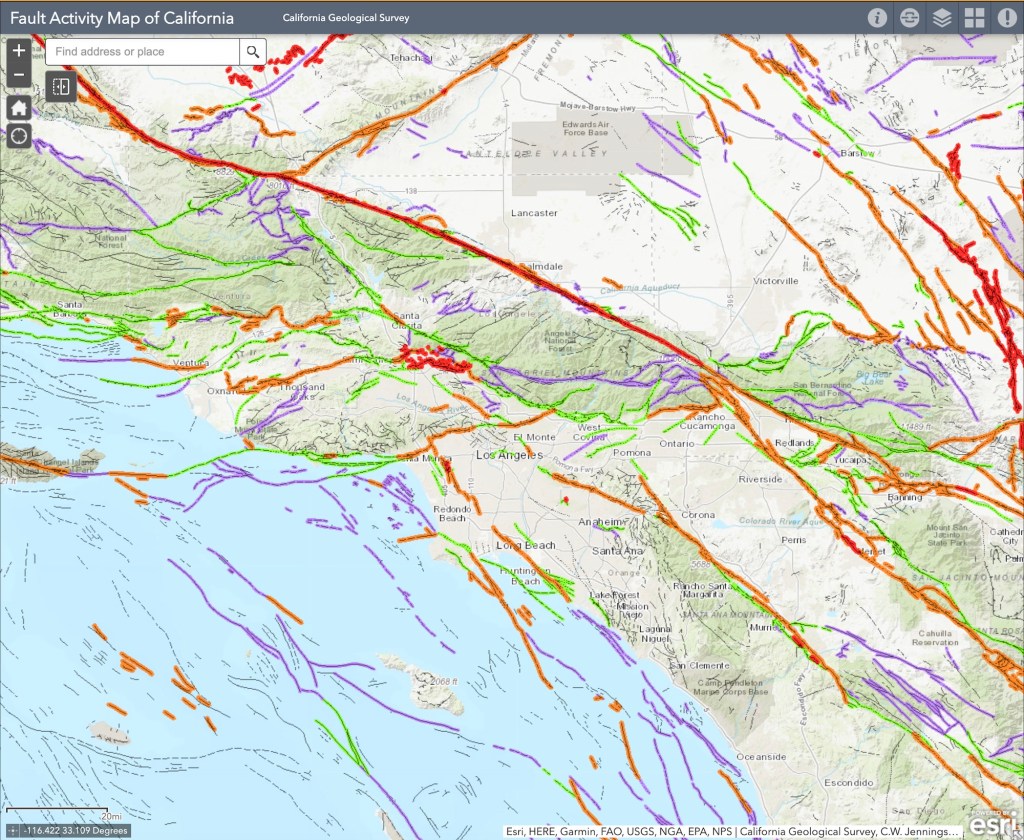
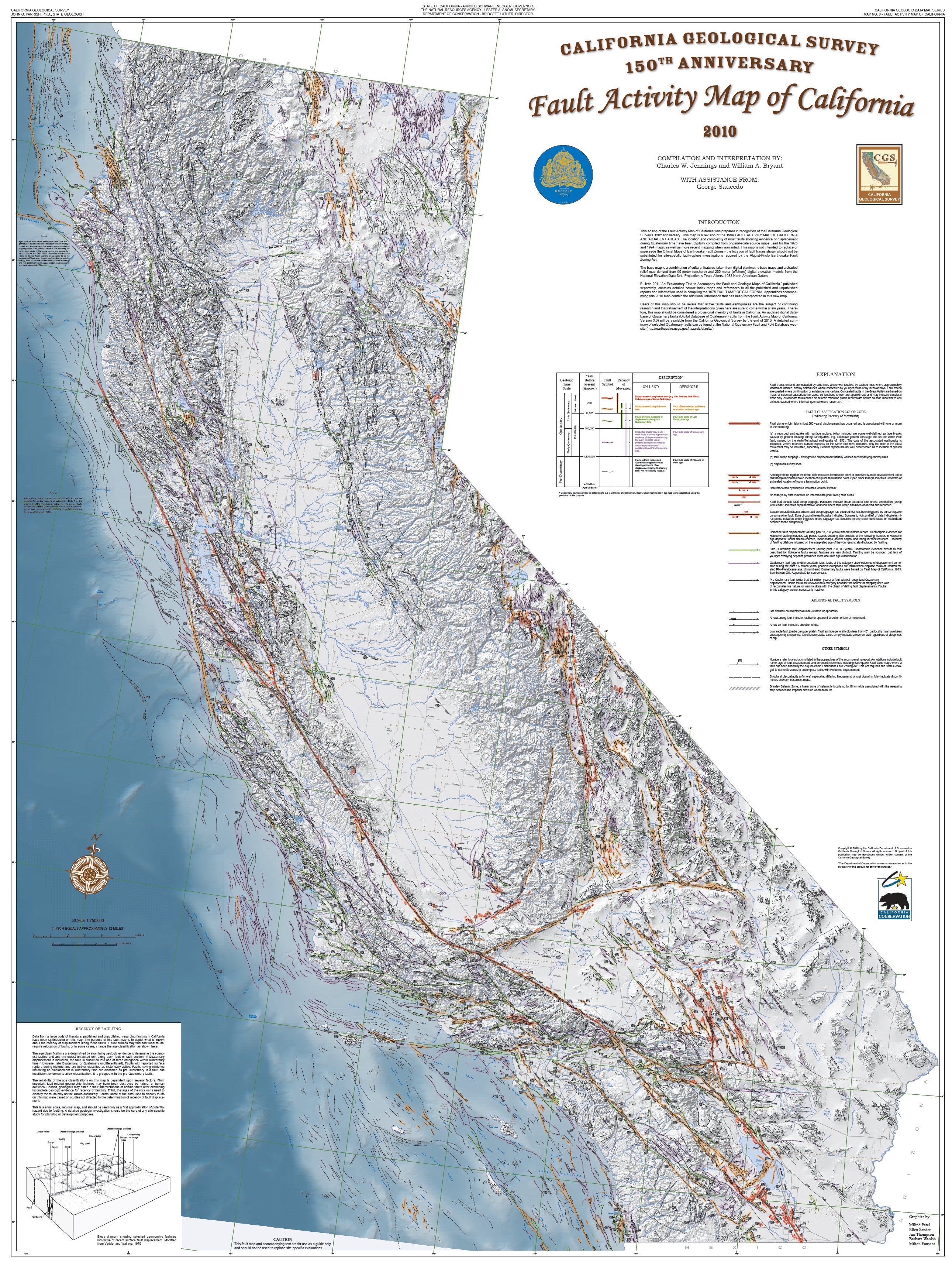
Fault Activity Map of LA Area in California (California Geological Survey) )
California, situated at the active boundary between the massive Pacific Plate and the North American Plate, became a prime natural laboratory for studying the principles of plate tectonics. The San Andreas Fault, a “right-lateral strike-slip fault” where the Pacific Plate slides northward relative to the North American Plate, is a direct consequence of this ongoing tectonic interaction. Places like Parkfield, California, lying directly on the fault, became the center of the seismic universe, offering invaluable opportunities to study the processes of locking and unlocking that precede earthquakes.
The San Andreas Fault at Wallace Creek. On January 9, 1857, the M 7.9 Fort Tejon earthquake occurred just north of the Carrizo Plain. Here, at Wallace Creek, the fault moved 30 feet (9m), forming the offset stream channel seen in the photo. (USGS)
The dramatic offsets of streams like Wallace Creek on the Carrizo Plain vividly demonstrate the horizontal movement along the fault. These offsets, where streams appear abruptly displaced, serve as clear, visual records of the fault’s slip history, showing just how much the land has shifted over time. Further proof of the movement of plates along the fault was uncovered in a remarkable investigation by Thomas Dibblee Jr., a pioneering field geologist who meticulously mapped vast regions of California. One of his most compelling discoveries was the striking geological similarity between rocks found at Pinnacles National Park and those in the Neenach Volcanic Field, located more than 195 miles to the southeast. Dibblee determined that these formations were once part of the same volcanic complex but had been separated by the gradual (but pretty damn quick in geological time) movement of the Pacific Plate along the San Andreas Fault over millions of years.
The insights gained from the plate tectonic revolution, sparked in part by that pivotal conference in Pacific Grove, continue to inform our understanding of California’s geological hazards and history. The work of scientists like Eldridge Moores and the subsequent advancements in the field have provided a robust framework for interpreting the state’s complex and ever-evolving landscape. The 1969 Penrose Conference marked not just a shift in scientific thinking but a fundamental unlocking of some of the Earth’s deep secrets, with California the place, once again, at the center of scientific advance.
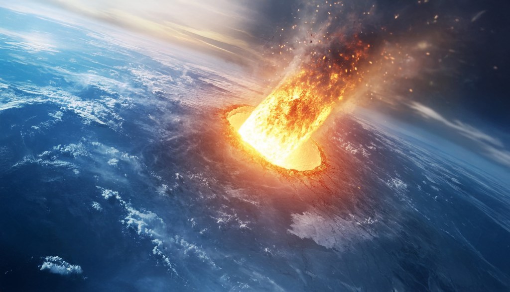
Artist’s rendering of the colossal Chicxulub meteor hurtling toward Earth, moments before impact on the Yucatán Peninsula, an event that reshaped life on our planet 66 million years ago. (Erik Olsen)
In 1977, Walter Alvarez arrived at Berkeley with rock samples from a small Italian town called Gubbio, unaware that they would help rewrite the history of life on Earth. He had spent years studying plate tectonics, but his father, Luis Alvarez, a Nobel Prize-winning physicist known for his unorthodox problem-solving at Berkeley, would propel him into a new kind of investigation, one deeply rooted in geology and Earth sciences. Their work led to one of the most significant scientific breakthroughs of the 20th century: the discovery that a massive meteorite impact was responsible for the extinction of the dinosaurs and much of life on Earth.
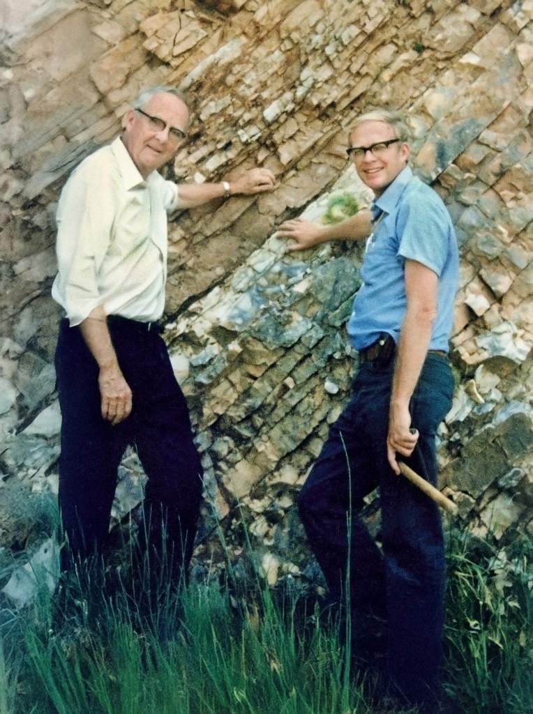
Luis and Walter Alvarez stand at the K–Pg boundary within the rock layers of a limestone outcrop near Gubbio, Italy, in 1981. This geological marker is linked to the asteroid impact that triggered the mass extinction 66 million years ago. (Lawrence Berkeley National Laboratory)
The samples Walter had collected contained a puzzling clay layer sandwiched between older and younger limestone deposits. This clay was rich in iridium—an element rare on Earth’s surface. The discovery of such an unusually high concentration of iridium in a single layer of buried rock was perplexing. Given that iridium is far more common in extraterrestrial bodies than on Earth’s surface, its presence suggested an extraordinary event—one that had no precedent in scientific understanding at the time. The implications were staggering: if this iridium had arrived all at once, it pointed to a cataclysmic event unlike anything previously considered in Earth’s history. Although some scientists had speculated about meteor impacts, solid evidence was scarce.
Alvarez determined that this layer corresponded precisely to the Cretaceous-Paleogene (K-Pg) boundary (formerly called Cretaceous–Tertiary or K–T boundary), the geological marker of the mass extinction that eradicated the non-avian dinosaurs 66 million years ago. Scientists had long debated the cause of this catastrophe, proposing theories ranging from volcanic activity to gradual climate change. But the Alvarez team would introduce a radical new idea—one that required looking beyond Earth.
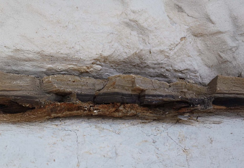
Layers of sediment at Stevns Klint, Denmark, showcasing the distinct K–Pg boundary. The dark clay layer, rich in iridium, marks the asteroid impact that led to the mass extinction of the dinosaurs 66 million years ago. (UNESCO)
Mass extinctions stand out so distinctly in the fossil record that the very structure of geological time is based on them. In 1841, geologist John Phillips divided life’s history into three chapters: the Paleozoic, or “ancient life”; the Mesozoic, or “middle life”; and the Cenozoic, or “new life.” These divisions were based on abrupt breaks in the fossil record, the most striking of which were the end-Permian extinction and the end-Cretaceous extinction, noted here. The fossils from these three eras were so different that Phillips originally believed they reflected separate acts of creation. Charles Lyell, one of the founders of modern geology, observed a “chasm” in the fossil record at the end of the Cretaceous period, where species such as belemnites, ammonites, and rudist bivalves vanished entirely. However, Lyell and later Charles Darwin dismissed these apparent sudden extinctions as mere gaps in the fossil record, preferring the idea of slow, gradual change (known as gradualism, versus catastrophism). Darwin famously compared the fossil record to a book where only scattered pages and fragments of lines had been preserved, making abrupt transitions appear more dramatic than they were.
Luis Alvarez was a physicist whose career had spanned a remarkable range of disciplines, from particle physics to aviation radar to Cold War forensics. He had a history of bold ideas, from using muon detectors to search for hidden chambers in pyramids to testing ballistic theories in the Kennedy assassination with watermelons. When Walter shared his perplexing stratigraphic findings, Luis proposed a novel method to measure how long the clay layer had taken to form: by analyzing its iridium content.
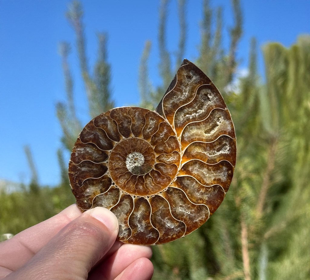
A fossilized ammonite, one of many marine species that vanished at the K–Pg boundary, marking a sharp “chasm” in the fossil record after the asteroid impact 66 million years ago. (Photo: Erik Olsen)
As discusses, Iridium is a rare element on Earth’s surface but is far more abundant in meteorites. Luis hypothesized that if the clay had accumulated slowly over thousands or millions of years, it would contain only tiny traces of iridium from cosmic dust. But if it had been deposited rapidly—perhaps by a single catastrophic event—it might show an anomalously high concentration of the element. He reached out to a Berkeley colleague, Frank Asaro, whose lab had the sophisticated equipment necessary for this kind of analysis.
Nine months after submitting their samples, Walter received a call. Asaro had found something extraordinary: the iridium levels in the clay layer were off the charts—orders of magnitude higher than expected. No one knew what to make of this. Was it a weird anomaly, or something more significant? Walter flew to Denmark to collect some late-Cretaceous sediments from a set of limestone cliffs known as Stevns Klint. At Stevns Klint, the end of the Cretaceous period shows up as a layer of clay that’s jet black and contains high amounts of organic material, including remnants of ancient marine life. When the stinky Danish samples were analyzed, they, too, revealed astronomical levels of iridium. A third set of samples, from the South Island of New Zealand, also showed an iridium “spike” right at the end of the Cretaceous. Luis, according to a colleague, reacted to the news “like a shark smelling blood”; he sensed the opportunity for a great discovery.
Stevns Klint’s towering white chalk cliffs stand as a dramatic testament to Earth’s history, preserving the thin, dark Fish Clay layer that marks the cataclysmic asteroid impact that ended the age of dinosaurs 66 million years ago. (UNESCO)
The Alvarezes batted around theories. But all the ones they could think of either didn’t fit the available data or were ruled out by further tests. Then, finally, after almost a year’s worth of dead ends, they arrived at the impact hypothesis. On an otherwise ordinary day sixty-six million years ago, an asteroid six miles wide collided with the Earth. Exploding on contact, it released energy on the order of a hundred million megatons of TNT, or more than a million of the most powerful H-bombs ever tested. Debris, including iridium from the pulverized asteroid, spread around the globe. Day turned to night, and temperatures plunged. A mass extinction ensued. Even groups that survived, like mammals and lizards, suffered dramatic die-offs in the aftermath. Who perished, and who survived, set the stage for the next 66 million years—including our own origin 300,000 years ago.
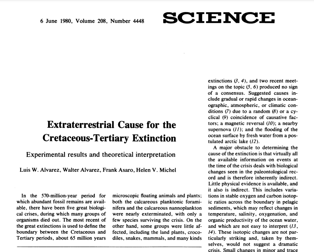
The Alvarezes wrote up the results from Gubbio and Stevns Klint and sent them, along with their proposed explanation, to Science. “I can remember working very hard to make that paper just as solid as it could possibly be,” Walter later recalled. Their paper, Extraterrestrial Cause for the Cretaceous-Tertiary Extinction, was published in June 1980. It generated enormous excitement, much of it beyond the bounds of paleontology, but it was also ridiculed by some who considered the idea far-fetched, if not ridiculous. Journals in disciplines ranging from clinical psychology to herpetology reported on the Alvarezes’ findings, and soon the idea of an end-Cretaceous asteroid was picked up by magazines like Time and Newsweek. In an essay in The New York Review of Books, the late American paleontologist Stephen Jay Gould quipped that linking dinosaurs—long an object of fascination—to a major cosmic event was “like a scheme a clever publisher might devise to ensure high readership.”
Inspired by the impact hypothesis, a group of astrophysicists led by Carl Sagan decided to try to model the effects of an all-out war and came up with the concept of “nuclear winter,” which, in turn, generated its own wave of media coverage. But as the discovery sank in among many professional paleontologists, the Alvarezes’ idea—and in many cases, the Alvarezes themselves—were met with hostility. “The apparent mass extinction is an artifact of statistics and poor understanding of the taxonomy,” one paleontologist told The New York Times. “The arrogance.”
Skepticism was immediate and intense. Paleontologists, geologists, and physicists debated the implications of the iridium anomaly. But as the search for supporting evidence intensified, the pieces of the puzzle began to fall into place. Shocked quartz, a telltale sign of high-energy impacts, was found at sites around the world. Soot deposits suggested massive wildfires had raged in the aftermath.
Artists rendering of T-rex and other dinosaurs prior to the impact of the asteroid (Erik Olsen)
In the early 1990s, conclusive evidence finally emerged. The Chicxulub crater, measuring roughly 180 kilometers across and buried under about half a mile of sediment in Mexico’s Yucatán Peninsula, was identified as the likely impact site. Although it was first detected by Mexico’s state-run oil company (PEMEX) in the 1950s during geophysical surveys, core samples taken decades later clinched the identification of Chicxulub as the long-sought impact site linked to the mass extinction that ended the Cretaceous era.
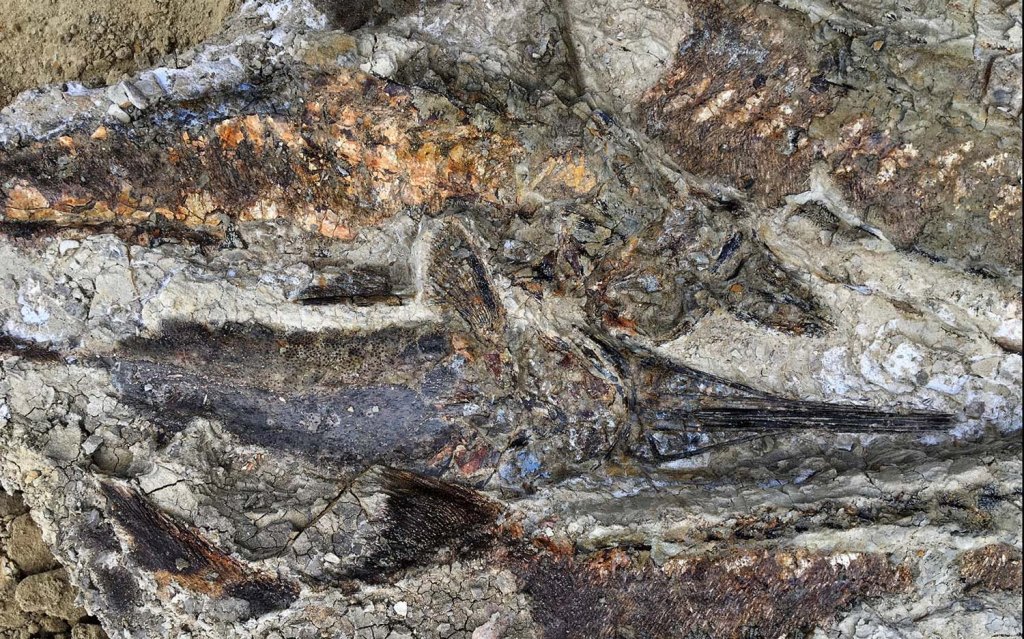
One of the more intriguing (if not astounding) recent discoveries tied to the end-Cretaceous impact is a site called Tanis, located in North Dakota’s Hell Creek Formation. Discovered in 2019 by a team led by Robert DePalma and spotlighted in a New Yorker article, Tanis preserves a remarkable snapshot of what appears to be the immediate aftermath of the asteroid strike.
Tanis fossils (Image credit: Courtesy of Robert DePalma)
The sedimentary layers at Tanis indicate large waves—often called “seiche waves”—that may have surged inland in the immediate aftermath of the impact. They also contain countless tiny glass spherules that rained down after the explosion. Known as microtektites, these blobs form when molten rock is hurled into the atmosphere by an asteroid collision and solidifies as it falls back to Earth. The site appears to hold them by the millions. In some cases, fish fossils have been found with these glass droplets lodged in their gills—a striking testament to how suddenly life was disrupted.
Although still under investigation, Tanis has drawn attention for its exceptional level of detail, potentially capturing events that took place within mere hours of the impact. The precise interpretation of this site continues to spark controversy among researchers. There is also controversy about the broader cause of the mass extinction itself: the main competing hypothesis is that the colossal “Deccan” volcanic eruptions, in what would become India, spewed enough sulfur and carbon dioxide into the atmosphere to cause a dramatic climatic shift. However, the wave-like deposits, along with the abundant glass spherules, suggest a rapid and violent disturbance consistent with a massive asteroid strike. Researchers hope to learn more about the precise sequence of disasters that followed—tidal waves, intense firestorms, and global darkness—further fleshing out the story of how the world changed so drastically, so quickly.
Glass spherules from cosmic impacts—microtektites from Tanis, tiny relics of Earth’s violent encounters with space. (Image credit: Courtesy of Robert DePalma)
All said, today the Alvarez hypothesis is widely accepted as the leading explanation for the K-Pg mass extinction. Their contributions at UC Berkeley—widely recognized as one of the world’s preeminent public institutions—not only reshaped our understanding of Earth’s history but also changed how we perceive planetary hazards. The realization that cosmic collisions have shaped life’s trajectory has led to renewed interest in asteroid detection and planetary defense.
Walter and Luis Alvarez’s discovery was a testament to the power of interdisciplinary science and the willingness to follow unconventional ideas. Their pursuit of an extraterrestrial explanation for a terrestrial mystery reshaped paleontology, geology, and astrophysics. What began with a father and son pondering an ancient Italian rock layer ended in a revelation that forever changed how we understand the history of life—and its vulnerability to forces from beyond our world.
The Legacy of One of North America’s Largest Volcanic Eruptions
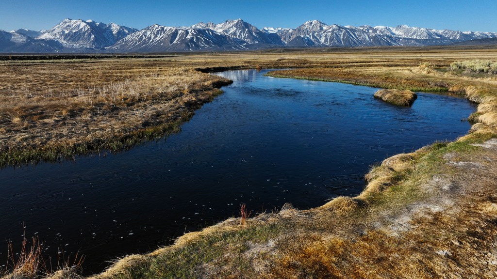
The Long Valley Caldera is one of the most active volcanic sites in the United States. Here, the Owens River flows through it, winding south through Owens Valley. (Erik Olsen)
Driving up Highway 395 toward Mammoth Lakes is one of the most breathtaking road trips in California. The highway winds through the rugged Eastern Sierra, offering stunning views of snow-capped peaks, alpine meadows, and vast chaparral plains. But beneath this dramatic landscape lurks a hidden danger—an ancient volcanic giant that still stirs beneath the surface.
The Long Valley Caldera in eastern California is an extraordinary geological feature, spanning about 20 miles in length and 11 miles in width. It owes its existence to one of the most dramatic volcanic events in Earth’s history, a supereruption that occurred approximately 760,000 years ago. This event, known as the Bishop Tuff eruption, ejected an estimated 150 cubic miles of molten rock and ash into the atmosphere, far surpassing the 1980 eruption of Mount St. Helens, which released just 0.3 cubic miles of material. The magnitude of the Bishop Tuff eruption resulted in the collapse of the ground above the magma chamber, creating a massive depression known as a caldera. In other words, it’s hard to get your head around how big this eruption was.
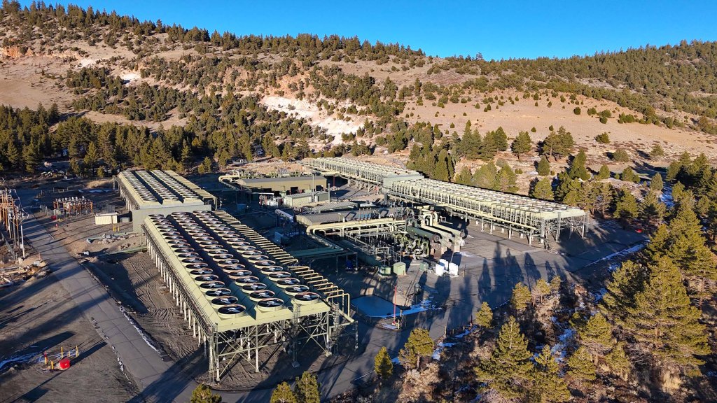
The Long Valley Caldera is a striking reminder of Earth’s immense, often hidden, volcanic power and its potential for destruction—located right here in California, near one of the nation’s most popular ski towns, Mammoth Lakes. Geothermal activity, visible in the form of hot springs, fumaroles, and hydrothermal systems, is a constant feature of the landscape. This activity has made the caldera a hub for geothermal energy production, with the Casa Diablo thermal power plant utilizing its subterranean heat to generate electricity. The energy produced at Casa Diablo is enough to power about 36,000 homes, making it an important renewable energy source for the region.
Casa Diablo Geothermal Facility, Long Valley Caldera, California (Erik Olsen)
The surface of the caldera is also marked by the Bishop Tuff, a layer of welded volcanic ash that provides a vivid record of the eruption’s intensity and the pyroclastic flows that reshaped the landscape. Pyroclastic flows are fast-moving, hot clouds of gas and volcanic material that can destroy everything in their path. Often they are considered more dangerous than the lava that pours forth from an erupting volcano. For example, pyroclastic flows killed far more people at Pompeii than lava, as the 79 AD eruption of Mount Vesuvius unleashed fast-moving clouds of superheated gas, ash, and volcanic debris that raced down the slopes at over 100 mph, reaching temperatures above 1,000°F, instantly asphyxiating and incinerating thousands, while the slower-moving lava played a minimal role in fatalities.
Geothermal features at the Long Valley Caldera commonly support microbial communities of thermophilic bacteria and algae, which thrive in the caldera’s hot springs and fumaroles. These organisms not only influence the terrain by contributing to mineral precipitation but also serve as models for studying life in extreme environments, offering analogs for early Earth and potential extraterrestrial ecosystems. Scientists are just beginning to understand how these bacteria live and thrive in deep ocean vent systems. In some areas around the Long Valley Caldera and Mono Lake, mats of thermophilic bacteria and algae thrive around the geothermal features, like the many hot tubs that dot the landscape, forming colorful, textured surfaces. These microbial communities contribute to the unique environment and can even make the ground feel crunchy underfoot, offering a tangible connection to the caldera’s dynamic, living systems.
The Owens River flows through the Long Valley Caldera near Mammoth Lakes, California (Erik Olsen)
While the caldera’s formation was sudden and catastrophic, its story stretches back millions of years. Scientific studies at the Long Valley Caldera have advanced our understanding of volcanic processes, crustal dynamics, and geothermal systems. The Long Valley Caldera sits within the Basin and Range Province, an area of North America characterized by extensional tectonics, where the Earth’s crust is being pulled apart, allowing magma to rise to the surface.
Using seismic tomography, researchers have mapped the magma chamber beneath the caldera, revealing a layered structure with a partially molten zone capped by solidified magma. This configuration, as highlighted in a 2023 study published in Science Advances, helps explain the periodic episodes of unrest observed in the caldera and provides a basis for assessing potential future activity. Before the eruption, the region experienced significant volcanic activity, with lava flows and smaller eruptions setting the stage for what was to come. Even after the formation of the caldera, volcanic activity continued in the area. Rhyolitic lava flows emerged within the caldera, and the nearby Mono-Inyo Craters volcanic chain has seen eruptions as recently as 600 years ago, underscoring the region’s enduring geological vitality.
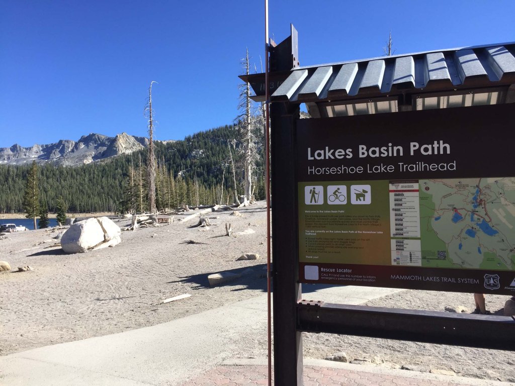
Horseshoe Lake in the Mammoth Lakes area, where underground carbon dioxide emissions have caused widespread tree die-off (Photo: Erik Olsen)
Another place where the region’s volcanic activity can be experienced firsthand is Horseshoe Lake, where carbon dioxide continuously seeps from the ground, suffocating tree roots and causing a vast die-off of trees. The result is a barren, almost ghostly landscape of skeletal trunks and lifeless ground, a stark reminder that Long Valley’s volcanic system is still active beneath the surface. The area is not just eerie but also hazardous—high concentrations of CO₂ can accumulate in low-lying areas, posing a serious risk to humans and animals. Signs around the site warn visitors of the danger, as pockets of odorless, colorless gas can be lethal if inhaled in high enough doses.
Hot Springs geological site near Mammoth Lakes, California. (Erik Olsen)
The caldera has not been entirely quiet since its dramatic birth. Ground deformation studies, using GPS and InSAR technology (satellites), have tracked uplift in the caldera’s floor, offering critical data on magma movement and hydrothermal activity. In a 2016 study published in Geophysical Research Letters, researchers linked changes in uplift patterns to deeper magmatic processes, reinforcing the importance of continuous monitoring. In 1980, a series of magnitude 6 earthquakes occurred along its southern margin, drawing the attention of volcanologists from USGS. These earthquakes were accompanied by noticeable uplift in the caldera’s floor, a sign of magma movement beneath the surface. Since then, the region has experienced periodic episodes of ground deformation and seismic activity, reminding scientists that the volcanic system beneath Long Valley is far from dormant.
Recent research has provided valuable insights into the caldera’s potential for future activity. While there is currently no indication of an imminent eruption, the area is closely monitored by the United States Geological Survey (USGS). This surveillance includes the measurement of ground deformation, gas emissions, and seismic activity, all of which serve as indicators of changes within the magma chamber. The 1980s unrest heightened awareness of the need for vigilance, particularly in regions where volcanic hazards could affect human populations.
Mono Lake is home to thermophilic (heat-loving) and extremophilic (extreme-condition-loving) bacteria. These microorganisms thrive in the lake’s unusual environment, characterized by high alkalinity, high salinity, and elevated levels of carbonate. (Erik Olsen)
As a result of these studies, the town of Mammoth Lakes took proactive measures to ensure public safety. Local authorities constructed an emergency evacuation route to serve as an escape in the event of a volcanic eruption or other natural disaster stemming from the Long Valley Caldera. After local businesses and residents expressed concerns that the original name implied danger, it was changed to Mammoth Scenic Loop to emphasize the area’s beauty and appeal. The United States Geological Survey (USGS) also intensified its monitoring efforts, implementing a color-coded alert system to communicate volcanic activity risks.
Beyond its scientific significance, the Long Valley Caldera is a destination for outdoor enthusiasts and other researchers. Numerous hot springs dot the landscape and are immensely popular among tourists and residents. Mammoth Lakes is one of California’s top recreational spots, providing amazing opportunities to hike and fish during the summer and excellent skiing in the winter months. For geologists, the caldera serves as a natural laboratory, providing an opportunity to study volcanic processes in a setting shaped by one of the most powerful eruptions in recent geological history.
The eastern Sierra reflected in Little Alkali Lake near the Long Valley Caldera (Erik Olsen)
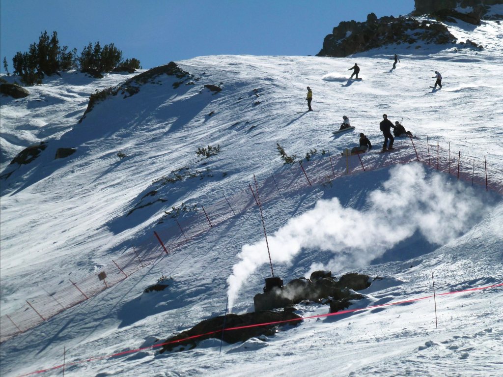
Of course, there remain certain dangers to all this volcanic activity. On April 6, 2006, three members of the Mammoth Mountain ski patrol tragically lost their lives after falling into a volcanic fumarole near the summit. The incident happened while they were conducting safety operations to secure a snow-covered geothermal vent following an unprecedented snowfall. If you’ve ever skied Mammoth before, there is a distinct sulphurous smell around the Christmas Bowl ski run at Chair 3 near McCoy Station.
Steam from an active fumarole near McCoy Station on Mammoth Mountain in 2012. (Flickr)
Standing at the center of the Long Valley Caldera, surrounded by the remnants of a prehistoric supereruption, offers a profound sense of scale and wonder. The vastness of the caldera, framed by the Sierra Nevada and dotted with geothermal vents, creates a landscape that feels alive yet ancient. It’s amazing place to be, both during the day and at night when the stars spread out across the gaping Sierra sky. The ground beneath your feet, shaped by cataclysmic forces, whispers of Earth’s power and the quiet persistence of geological time. Yet beneath the surface, the processes that shaped it continue to evolve, as magma slowly shifts and geothermal systems release heat from the planet’s interior. As research continues and technology advances, the Long Valley Caldera will undoubtedly yield further insights into the intricate workings of our planet’s volcanic systems.
Rare earth metals are now essential to the global economy, powering everything from smartphones and electric vehicles to wind turbines and defense systems. As China continues to dominate the market—producing more than 70% of the world’s supply—the urgency to find reliable alternatives has grown. The United States is locked in a high-stakes race to secure new sources of rare earth elements, along with other critical minerals like lithium and nickel, which are key to the clean energy transition. At the center of this effort is a storied mine in California that not only helped launch the rare earth industry decades ago but now stands as America’s most promising hope for rebuilding a domestic supply chain.
Mining shaped California’s growth, from the 1849 Gold Rush to key industries like mercury, silver, copper, tungsten, and boron. While some have declined, others, like the Rio Tinto U.S. Borax Mine in Boron, California, remain major global suppliers, while rare earth element extraction continues to be an important industry.
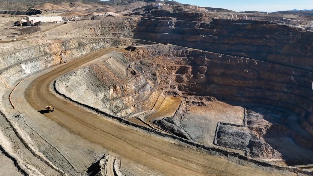
MP Materials’ Mountain Pass rare earths mine in California is a remarkable example of industrial resurgence and the strategic importance of critical metals in the modern era. Located in Mountain Pass in the remote Californian desert near the Nevada border (it’s easily viewable from Interstate 15), this mine, initially developed in the mid-20th century, has seen dramatic shifts in fortune, technology, and geopolitics, reflecting the complex role rare earth elements (REEs) play in global industries.
The rock at Mountain Pass contains an average of 7 to 8 percent rare earth elements—a remarkably high concentration by industry standards. This richness is a key factor in the mine’s potential. However, extracting these valuable elements from the surrounding material remains a challenge.
Discovered in 1949 while prospectors searched for uranium, the Mountain Pass deposit instead revealed bastnaesite, an ore rich in rare earth elements like neodymium, europium, and dysprosium. These elements are indispensable to modern technologies, powering innovations across consumer electronics, environmental solutions, and advanced military systems.
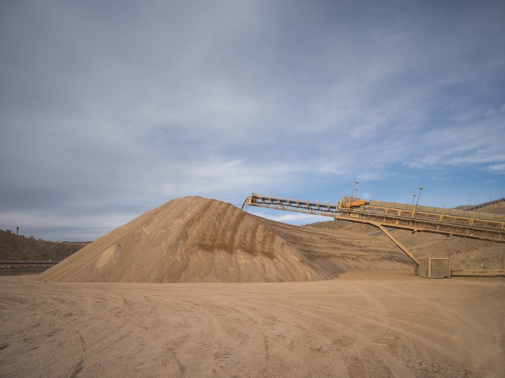
A computer-controlled arm deposits the raw crushed ore into a mound at the MP Materials mine and ore processing site in Mountain Pass, CA. (Courtesy: MP Materials)
Smartphones, for instance, are packed with rare earth elements that enable their functionality. Europium and gadolinium enhance the brightness and color of their screens. Lanthanum and praseodymium contribute to the efficiency of their circuits, while terbium and dysprosium enable the compact, high-performance speakers. Beyond smartphones, rare earth elements are essential to electric vehicles and renewable energy technologies, particularly in the production of permanent magnets. Thanks to their distinctive atomic structure, rare earth elements can produce magnetic fields far stronger than those generated by other magnetizable materials like iron. This exceptional capability arises from their partially filled 4f electron shell, which is shielded by outer electrons. This configuration not only gives them unique magnetic properties but also results in complex electronic arrangements and a tendency for unpaired electrons with similar spins. These characteristics make rare earth elements indispensable for creating the most advanced and powerful commercial magnets, as well as for applications in cutting-edge electronics.
Permanent magnets are among the most significant uses of rare earths, as they convert motion into electricity and vice versa. In the 1980s, scientists discovered that adding small amounts of rare earth metals like neodymium and dysprosium to iron and boron created incredibly powerful magnets. These magnets are ubiquitous in modern technology: tiny ones make your phone vibrate, medium-sized ones power the wheels of electric cars, and massive ones in wind turbines transform the motion of air into electricity. A single wind turbine can require up to 500 pounds of rare earth metals, highlighting their critical role in reducing greenhouse gas emissions.
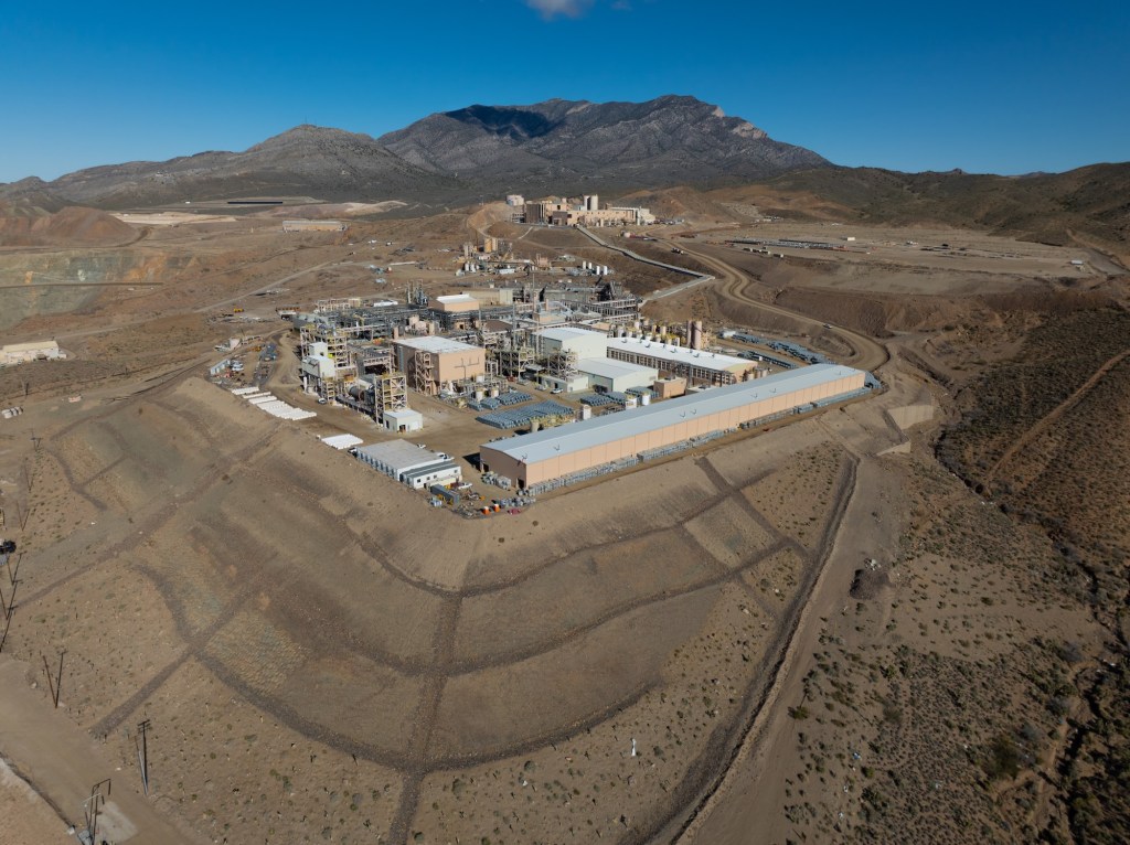
MP Materials Processing Facility in Mountain Pass, California (Courtesy: MP Materials)
Additionally, rare earths play a significant role in environmental applications. Cerium is used in catalytic converters to reduce vehicle emissions, while lanthanum enhances the efficiency of water purification systems. Rare earth-based phosphors are employed in energy-efficient lighting, such as LED bulbs, which are central to reducing global energy consumption.
The importance of these elements underpins the strategic value of deposits like Mountain Pass, making the extraction and refinement of rare earths a critical aspect of both technological progress and national security. In the military domain, rare earths are integral to cutting-edge systems. They are used in the production of advanced lasers, radar systems, night vision equipment, missile guidance systems, and jet engines. According the the Department of Defense, for example, the F-35 Lightning II aircraft requires more than 900 pounds of rare earth elements. Alloys containing rare earth elements also strengthen armored vehicles, while lanthanum aids in camera lenses and night vision optics, giving military forces a strategic advantage.
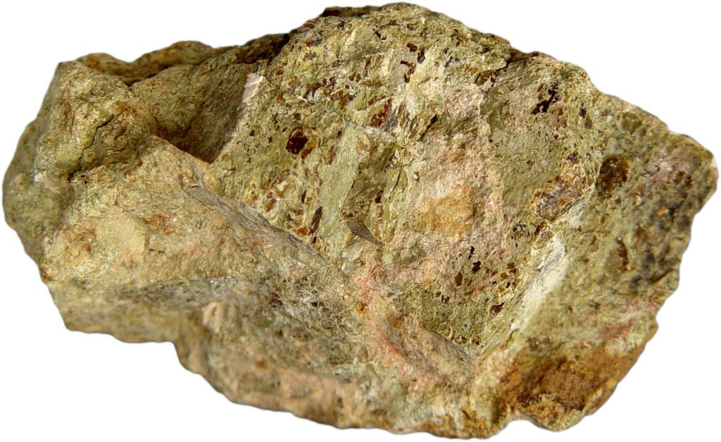
Bastnaesite concentrate. Bastnaesite is a mineral that plays a crucial role in the production of rare earth metals. (Courtesy of MP Materials)
To fully appreciate the significance of rare earth elements and their crucial role in the United State’s economic future, it’s essential to explore the history of Mountain Pass, one of the most important rare earth mines in the world. This storied site not only played a pivotal role in meeting the surging demand for these elements but also serves as a case study in the challenges of balancing industrial ambition with environmental responsibility.
The Molybdenum Corporation of America, later renamed Molycorp, initially capitalized on the booming demand for europium in color televisions during the 1960s. In 1952, the company acquired the Mountain Pass site, recognizing its rich deposits of rare earth minerals. As the first major player in rare earths in the United States, it began operations at Mountain Pass, establishing a foothold in the burgeoning industry. Over the ensuing decades, Mountain Pass became the world’s premier source of rare earths, serving a growing market for advanced materials.
By the 1990s, however, the mine faced significant challenges. Environmental damage caused by leaks of heavy metals andradioactive wastewater led to regulatory scrutiny and costly fines, culminating in the mine’s closure. During its dormancy, global rare earth production shifted overwhelmingly to China, which gained near-monopoly control over the market. By the time Molycorp attempted to revive the site in the early 2000s, it struggled against operational inefficiencies, low rare earth prices, and fierce Chinese competition. Molycorp eventually declared bankruptcy, leaving the mine idle once again.
MP Materials Mine Facility (Photo: Erik Olsen)
In 2017, MP Materials, led by investors including Michael Rosenthal and Jim Litinsky, acquired the shuttered Mountain Pass mine after recognizing its untapped potential. Initially, they anticipated an established mining or strategic buyer would emerge. Faced with the risk of losing the mine’s permit and seeing it permanently closed through reclamation, they made the bold decision to operate it themselves. To restart operations, MP Materials partnered with Shenghe Resources, a Chinese state-backed company that provided critical early funding and became the company’s primary customer. Through this arrangement, MP shipped raw rare earth concentrate to China for processing, laying the foundation for a business model that was heavily reliant on the Chinese supply chain.
Over the next several years, Mountain Pass far exceeded expectations. By 2022, it was producing 42,000 metric tons of rare earth oxides—three times the best output achieved under its previous owner, Molycorp—and accounted for about 15% of global production. In 2024, the mine hit a U.S. production record with over 45,000 metric tons of REO in concentrate. But even as the mine’s output surged, MP Materials’ ties to China remained central to its operations. Shenghe not only purchased the bulk of that concentrate but also maintained an 8% ownership stake. In 2024, roughly 80% of MP’s revenue came from this relationship. That changed in 2025, when China imposed steep tariffs and new export restrictions. MP responded by halting all shipments to China, shifting instead to processing much of its output domestically and selling to U.S.-aligned markets like Japan and South Korea. It has since invested nearly $1 billion to build out a full domestic supply chain and launched a joint venture with Saudi Arabia’s Ma’aden, marking a decisive pivot away from reliance on China.
The processing of rare earth elements, particularly for high-value applications like magnets, involves a complex, multi-step value chain. It begins with extraction, where ores containing rare earths are mined, followed by beneficiation, a process that concentrates the ore to increase its rare earth content. Next, separation and refining isolate individual rare earth oxides through solvent extraction or other chemical methods. These refined oxides then undergo metallization, where they are reduced into their metallic form, making them suitable for further industrial use. The metals are then alloyed with other elements to enhance their properties, and finally, the material is shaped into high-performance magnets essential for applications in electric vehicles, wind turbines, and advanced electronics. Each of these steps presents significant technical, economic, and environmental challenges, making rare earth processing one of the most intricate and strategically important supply chains in modern technology.
Bastnaesite ore (Wikipedia)
Despite MP Materials’ success and efforts to ramp up facets of processing at its Mountain Pass mine in California, a critical portion of the rare earth refining process—metallization, alloying, and magnet manufacturing—remains dependent on other countries, including China and Japan. These procedures are both intricate and environmentally taxing, and California’s stringent regulatory framework, designed to prioritize environmental protections, has made domestic processing particularly challenging. Across the rare earths industry, this dependence on Chinese facilities exposes a significant vulnerability in the rare earth supply chain, leaving the United States and other countries reliant on foreign infrastructure to produce critical materials essential for technologies such as electric vehicles and advanced military systems.
However, to address the dependency on foreign processing, MP Materials is investing heavily in building a fully domestic rare earth supply chain. At its Mountain Pass mine in California, the company is enhancing its processing and separation capabilities to refine rare earth elements on-site. Meanwhile, at its new Independence facility in Fort Worth, Texas, MP Materials has begun producingneodymium-praseodymium (NdPr) metal and trialing sintered neodymium-iron-boron (NdFeB) magnets. This facility marks the first domestic production of these critical materials in decades, with the capability to produce 1,000 metric tons of magnets annually, amounting to the production of roughly half a million EV motors.
“This is our ultimate goal,” says Matt Sloustcher, EVP of Corporate Affairs for MP Materials. “To handle the entire separation and refining process on-site—but that ramp-up takes time.”
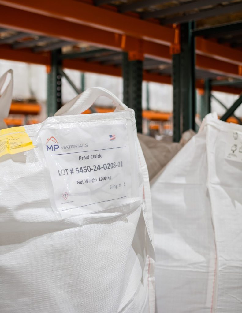
Individual slings of PrNd Oxide, the primary product produced at MP Materials. (Courtesy: MP Materials)
MP Materials asserts that the new U.S.-based rare earth supply chain it is developing will be a “zero discharge” facility, recycling all water used on-site and disposing of dry waste in lined landfills. That will make it a far more environmentally sustainable than its counterparts in Asia, where rare earth mining and processing have led to severe pollution and ecological damage. The company says it is making progress. MP Materials’ Sloustcher pointed California Curated to a Life Cycle Assessment (LCA) study published in the American Chemical Society which “found that NdFeB magnets produced from Mountain Pass ore have about one-third the environmental footprint of those from Bayan Obo, China’s largest rare earth mine.”
“With record-setting upstream and midstream production at Mountain Pass and both metal and magnet production underway at Independence , we have reached a significant turning point for MP and U.S. competitiveness in a vital sector,” said James Litinsky, Founder, Chairman, and CEO of MP Materials in a company release.
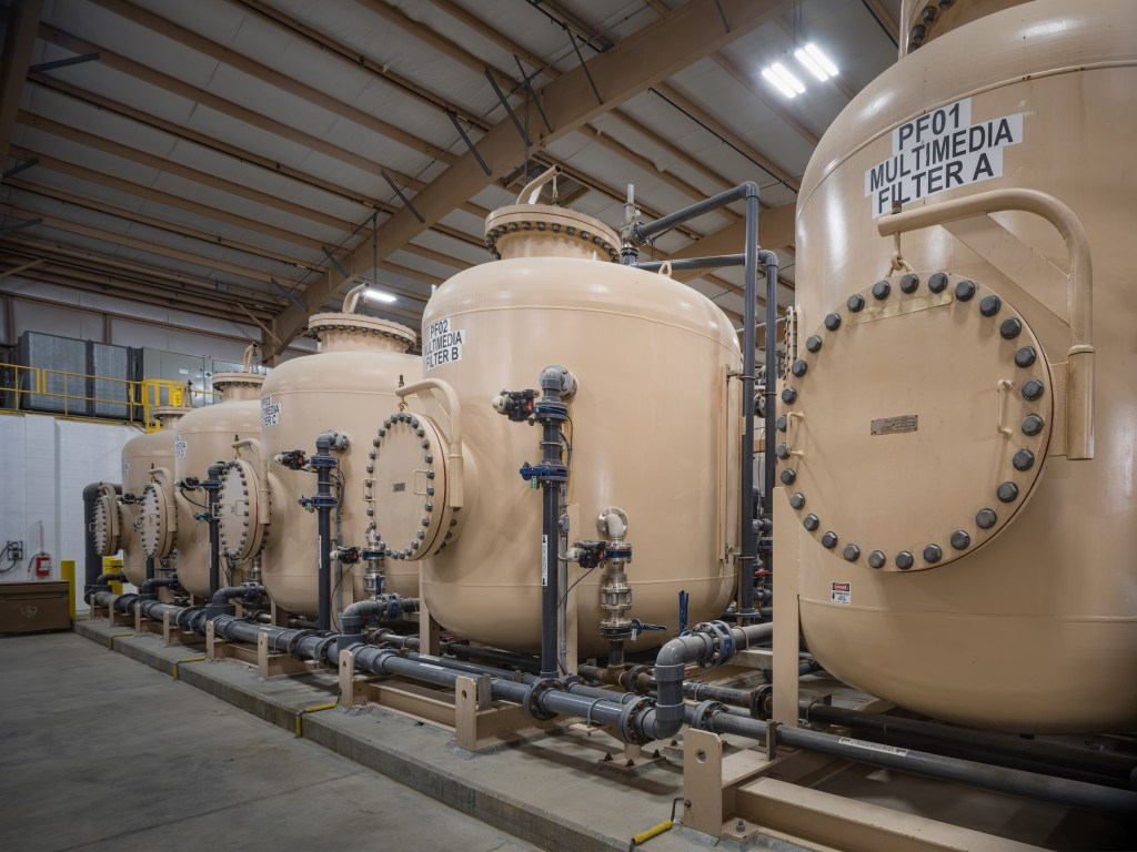
Interior view of the Water Treatment Plant at the MP Materials mine and ore processing site in Mountain Pass, CA. (Courtesy: MP Materials)
MP Materials has also partnered with General Motors to produce rare earth magnets for electric vehicles, signaling its commitment to integrating domestic production into key industries. The push for domestic EV production is not just about economic security but also about environmental sustainability, as reducing the carbon footprint of mining, processing, and transportation aligns with the broader goal of clean energy independence.
The resurgence of the Mountain Pass mine aligns with a broader initiative by the U.S. government to secure domestic supplies of critical minerals. Recognizing Mountain Pass as a strategic asset, the Department of Defense awarded MP Materials a $35 million contract in February 2022 to design and build a facility for processing heavy rare earth elements at the mine’s California site Additionally, the Department of Energy has been actively supporting projects to strengthen the domestic supply chain for critical minerals, including rare earth elements, through various funding initiatives.
Mountain Pass’s operations, however, highlight the challenges inherent in mining rare earths. The extraction process involves significant environmental risks, particularly in managing wastewater and tailings ponds. MP Materials claims to prioritize sustainable practices, yet its long-term ability to minimize environmental impact while scaling production remains under scrutiny. The mine’s bastnaesite ore, with rare earth concentrations of 7–8%, is among the richest globally, making it economically competitive. Still, as mentioned above, processing bastnaesite to isolate pure rare earth elements involves complex chemical treatments, underscoring why global production remains concentrated in a few countries.
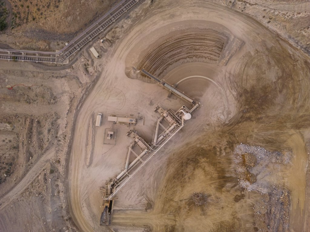
Overhead view of the Crusher at the MP Materials mine and ore processing site in Mountain Pass, CA. (Courtesy: MP Materials)
Today, Mountain Pass is not only a critical supplier but also a symbol of U.S. efforts to reduce dependency on Chinese rare earth exports as well as other minerals such as lithium and copper vital to a transition to clean energy technology. As demand for REEs surges with advancements in green energy and technology, the increasing mine’s output supports the production of permanent magnets used in electric motors, wind turbines, and countless other applications. This resurgence in domestic rare earth production offers hope for a revitalized U.S.-based supply chain, reducing dependence on foreign sources and ensuring a more stable, sustainable future for critical mineral access.
However, significant obstacles remain, including the environmental challenges of mining, the high costs of refining and processing, and the need to develop advanced manufacturing infrastructure. Overcoming these barriers will require coordinated efforts from industry, government, and researchers to make domestic production both economically viable and environmentally responsible, ensuring a truly climate-friendly future. With the global race for critical minerals intensifying, MP Materials’ success demonstrates the potential—and challenges—of revitalizing domestic mining infrastructure in an era of heightened resource competition.
…and they shall beat their swords into plowshares, and their spears into pruning hooks: nation shall not lift up sword against nation, neither shall they learn war any more. Micah 4:3
Fake rendering of an atomic bomb exploding near road in Mojave Desert.
In the early 1960s, the U.S. government seriously considered using nuclear bombs to solve a civil engineering challenge: building a highway bypass through the rugged terrain of California’s Mojave Desert. Dubbed Project Carryall, the plan would have involved detonating a series of nuclear devices to blast a path for a stretch of highway and railroad intended to reroute Route 66 and ease congestion. The idea sounds absurd today, but at the time, the U.S. was actively exploring ways to use nuclear energy for peaceful purposes.
Project Carryall was part of a broader initiative known as Operation Plowshare, launched by the Atomic Energy Commission (AEC) to explore the potential of using nuclear explosions in constructive ways. Proposed ambitious projects included using nuclear explosions for excavation, mining, and infrastructure development. Ideas included creating artificial harbors, digging new canals like the “Pan-Atomic Canal,” stimulating natural gas production through underground detonations, and creating tunnels or underground reservoirs.
The idea was conceived in 1951 as a way of “beating atomic arms into plowshares.” The underlying logic was that controlled nuclear blasts could do the work of traditional excavation on a much larger and faster scale. Proponents of the project, including argued that using nuclear bombs could reduce the time and cost involved in these types of infrastructure projects, providing a technological leap forward.
Edward Teller, a key figure in the development of the hydrogen bomb, was actively involved in promoting Project Carryall as part of his broader support for Operation Plowshare. His earlier contributions to the successful creation of the H-bomb in 1952 helped cement his reputation as a leading nuclear physicist, and he saw projects like Carryall as a way to repurpose atomic energy for large-scale civil engineering projects.
Teller was a highly controversial figure due to his staunch advocacy for the use of nuclear technology, both in weapons development and peaceful applications like Project Carryall. His role in the hydrogen bomb’s creation, along with his support for large-scale nuclear projects, earned him both admiration and criticism, particularly after he testified against Robert Oppenheimer, which many viewed as a betrayal of his fellow scientists. Teller, who died in 2003, went to his grave convinced that nuclear geo-engineering was a missed opportunity.
Schematic and map of Project Carryall in the California Desert
The proposal for Project Carryall specifically targeted the construction of a new transportation corridor in Southern California. By the early 1960s, Route 66 had become notorious for traffic bottlenecks, particularly as postwar car ownership and travel boomed. To bypass the tight curves and mountainous terrain of the Cajon Pass area, engineers envisioned a straighter, more efficient route through the Bristol Mountains. The task of carving out such a path would have been an immense undertaking with traditional methods. Enter the nuclear option. Maybe we could dig with the bomb.
A feasibility study conducted by the Atchison, Topeka, and Santa Fe Railway (ATSF) sought assistance from the U.S. Atomic Energy Commission citing the Bristol Mountains as the ideal location for the project. Collaborating with the Commission’s San Francisco office and the Lawrence Radiation Laboratory (now the Lawrence Berkeley National Laboratory and a Department of Energy-funded U.C. Berkeley offshoot), the study concluded that a nuclear-excavated bypass was not only “technically feasible” but also significantly cheaper than traditional excavation methods.
Public domain, via Atomic Skies
Project Carryall aimed to carve a path through the Bristol Mountains, about 11 miles north of Amboy, California, a popular stop along Route 66, using 22 nuclear devices with yields ranging from 20 to 200 kilotons. Engineers planned to drill holes along a 10,940-foot section of the mountainside, each 36 inches in diameter and between 343 to 783 feet deep, reinforced with corrugated metal to house the nuclear explosives. These detonations, which would have been fired in two groups of 11 simultaneously, were expected to remove around 68 million cubic yards of earth, creating a cut up to 360 feet deep and between 600 and 1,300 feet wide. The total yield of the explosions, 1,730 kilotons, was equivalent to about 115 times the explosive power of Little Boy, the atomic bomb dropped on Hiroshima. The blasts would have essentially carved the path through the mountains in seconds.
Project Storax Sedan shallow underground nuclear test by the United States, used for a cratering experiment. 6 July 1962, Nevada Test Site Yield: 104 kt. The main purpose of the detonation was to asses the non military dimension of a nuclear explosion.
Citing data from 1962’s Project Sedan, the Atomic Energy Commission estimated that work in the area could safely resume just four days after the nuclear detonation. This projection was highlighted in a 2011 report by the Desert Research Institute, affiliated with the University of Nevada, Reno, which examined the feasibility and safety of such operations during the era of nuclear excavation projects. The Sedan nuclear test displaced around 12 million tons of earth with a single 104-kiloton blast. This test created a massive crater and sent radioactive debris into the atmosphere.
The projected combined costs for the railroad tunnel and highway in Project Carryall were estimated at $21.8 million, equivalent to roughly $216.96 million today. The nuclear excavation method was expected to cost $13.8 million (about $137.34 million in 2023 dollars), excluding the price of the nuclear devices themselves. Traditional excavation was estimated at $50 million, or approximately $497.61 million today. Although the cost of the nuclear devices was classified, it was assumed to be less than the gap between conventional and nuclear methods, making the nuclear approach seem more cost-effective at the time.
Mid-20th century scientists envisioned a new Panama Canal blasted down to sea level with thermonuclear explosives. (Lawrence Livermore National Laboratory)
As wild as this plan seems today, it wasn’t entirely out of place in the context of its time. The Cold War era was marked by an optimistic belief in the power of technology, particularly nuclear technology, to solve big problems. With Operation Plowshare, the U.S. government was looking for ways to demonstrate the peaceful uses of nuclear energy. Proponents of Project Carryall framed the use of nuclear devices for highway construction as a sign of progress, imagining a future where atomic energy could help reshape the American landscape in new and innovative ways.
However, there were significant hurdles to the project’s realization, many of them environmental and logistical. Although the AEC touted the precision of the nuclear blasts, the potential consequences of radiation were harder to dismiss. The detonation of nearly two dozen nuclear devices in the middle of California’s desert would likely have released dangerous levels of radioactive fallout, contaminating the land, air, and possibly even water supplies for nearby communities. Engineers also anticipated “occasional rock missiles” projected as far as 4,000 feet (1,200 m) from the blasts. While the nearby town of Amboy was not expected to experience significant effects, there was greater concern about the impact on a natural gas pipeline in the vicinity, which would require pre-blast testing to assess potential risks. Further, concerns about the safety of workers, residents, and wildlife made it increasingly difficult to justify the project.
Project Carryall was abandoned due to a combination of environmental, political, and logistical concerns. As public awareness of the dangers of nuclear fallout grew, the potential for radioactive contamination became a significant issue, especially with the predicted large dust cloud and the risk to nearby natural gas pipelines. The signing of the Limited Test Ban Treaty in 1963, which prohibited nuclear tests that produced radioactive debris across borders, further complicated the project’s prospects. Moreover, the environmental movement was gaining traction during the 1960s, leading to increased opposition to nuclear excavation. Traditional construction methods, though more costly and time-consuming, were ultimately deemed safer and more politically feasible. By the mid-1960s, the California Highway Division (Now Caltrans) withdrew from the project, and nuclear excavation was abandoned in favor of conventional approaches. The highway bypass was eventually constructed using traditional methods, without the need for nuclear blasts.
Project Carryall Marker sign in Ludlow, California
While it never came to fruition, Project Carryall remains a striking example of the U.S. government’s audacious postwar optimism and the belief that nuclear technology could solve even the most mundane problems. It serves as a reminder of the tension between technological ambition and environmental responsibility—a lesson that resonates even more today. The story of Project Carryall is one of the stranger chapters in the history of America’s nuclear age, but it highlights how far we’ve come in understanding the limits and dangers of nuclear energy beyond warfare.
Today, the Carryall project is memorialized by a roadside marker in Ludlow, the nearest town to the west of the site.
Ansel Adams, with his iconic black-and-white photographs of Yosemite and the Sierra Nevada, likely never realized that his lens was capturing not just breathtaking landscapes but one of geology’s most fascinating phenomena—the Sierra Batholith, a colossal formation of granite that lies at the heart of the mountains he immortalized. The Sierra Batholith is a massive granite body that reveals the tale of ancient volcanic activity in California, showcasing nature and time as master artists, and the slow tectonic forces that have shaped the Earth’s crust over millions of years.
Discussing the Sierra batholith, the writer John McPhee wrote: “It lies inside the Sierra like a big zeppelin. Geologists in their field boots mapping outcrops may not have been able to find a bottom, but geophysicists can, or think they can, and they say it is six miles down. If so, the batholith weighs a quadrillion tons, and its volume is at least a hundred and fifty thousand cubic miles.”
The Sierra Batholith is unique because it represents a massive, exposed section of the Earth’s continental crust formed deep underground during the Mesozoic era, between 85 and 220 million years ago. Unlike typical mountain ranges that form through surface processes, the Sierra Batholith was created as molten rock, or magma, cooled and solidified far beneath the Earth’s surface.
A batholith is a gargantuan underground rock formation made up mostly of intrusive igneous rock, predominantly granite.” Intrusive” in this context doesn’t mean the rock is barging into conversations—it refers to rock that formed beneath the Earth’s surface as molten magma slowly cooled and solidified. The Sierra Nevada batholith is a titan among batholiths, covering an area of about 40,000 square kilometers (16,000 sq. miles).
How did this underground monolith come into being? Picture the Earth’s crust as a sort of geological lasagna, consisting of multiple layers of rock. When the Pacific Plate and the North American Plate crashed into one another—intense pressure and heat accumulated deep within the Earth. The result is the formation of magma, which then cooled and solidified slowly below the Earth’s crust. The slow cooling allowed minerals to crystallize, creating a texture in the rock that’s coarse and beautifully patterned—not unlike granite countertops for your kitchen, but on a monumental scale.
The Sierra Nevada Batholith was only revealed after vertical miles of Earth’s crust above it eroded away. Stretching from just north of Lake Tahoe to Tehachapi Pass, this massive formation resembles an air mattress—450 miles long, 60 miles wide, and about eight to nine miles thick, with six miles still buried underground and two to three miles towering above the surrounding landscape. The sheer size, scale, and immense mass are awe-inspiring—and it’s all right here in California.
This creation process was far from uniform—the batholith is actually not a single mass, per se, but a cluster of blobs of molten rock fused at the edges. These blobs, called plutons, are clustered together like cobblestones in a street or the uneven domes of a bubble wrap sheet. What we now see are the rounded tops of about 20 oval-shaped plutons, each around 10 by 20 miles in size. Chemically, each blob varies slightly. Granite, made mostly of silica, which forms 60 to 80 percent of its mass, gets its whitish hue from silica, with black flecks of feldspar and hornblende, sometimes tinged with reddish iron oxide. The slower the cooling, the more time quartz crystals had to form.
One of the largest and youngest plutons in the Sierra is called the Whitney Intrusive Suite, and it is the foundation of the nation’s tallest peak outside of Alaska, Mt. Whitney.
A geologic map of Yosemite National Park showing the many intrusions that make up this part of the Sierra Nevada Batholith.
Natural forces like wind, water, and glaciers have gradually eroded the Earth’s surface, exposing the underlying granite. Imagine the work of an infinitely patient sculptor, slowly chipping away at a block of marble year after year, century after century. Except here, the sculptor is Mother Nature, and the time frame is geological, spanning epochs rather than mere decades or centuries.
One fascinating facet of this story is how glaciers have been among the most dramatic artists in nature’s magnificent art gallery. Their slow, relentless movement sculpted features like Yosemite Valley, one of the most breathtaking landscapes on Earth.
Half Dome in Yosemite, a granite giant of the Sierra Batholith, showcases millions of years of cooling magma and erosion. (Erik Olsen)
But the Sierra Nevada batholith isn’t just a stationary slab of rock—it’s also a dynamic part of California’s ecosystem. The granite affects the way water moves or stagnates in the region, influencing local hydrology and, by extension, water supply. When the snow in the Sierra Nevada mountains melts, it feeds rivers and lakes, many of which are essential to California’s agricultural and urban areas. Imagine the batholith as a silent but vital cog in the wheel of California’s complex water system.
One excellent resource to learn more about the Sierra and the Sierra batholith is Kim Stanley Robinson‘s The High Sierra: A Love Story. The book is an evocative blend of memoir, natural history, and environmental meditation, centered around the Sierra Nevada mountains, a region Robinson has deeply cherished for decades. Robinson, widely regarded as one of today’s greatest science fiction writers, has authored numerous books on topics ranging from space exploration to climate change. Yet one of his deepest passions is hiking in the Sierra.
Half Dome, carved from the granite of the Sierra Batholith, offers a glimpse into Earth’s deep history, where ancient magma chambers solidified beneath the surface and were gradually revealed through uplift and erosion. (Erik Olsen)
In the book, he explores the geologic grandeur, ecological richness, and personal significance of this mountain range, offering readers a vivid portrayal of its granite peaks, alpine meadows, and glacial valleys. Robinson intertwines his own hiking experiences with reflections on the Sierra’s geological formation, the indigenous histories of the land, and the environmental challenges it faces today. His narrative is as much an ode to the beauty and solitude of the Sierra as it is a call for greater environmental stewardship, showcasing his talent for combining science with a profound emotional connection to the natural world. (If you haven’t yet read one of his books, you should. Start with Red Mars.)
Sierra Nevada from Lone Pine (Erik Olsen)
If you’re the adventurous type with a penchant for rock climbing or hiking, the Sierra Nevada batholith serves as both your playground and your classroom. Whether you’re scaling the granite walls of El Capitan or hiking the trails near Lake Tahoe, you’re traversing a landscape that’s millions of years old. Each crevice, each outcrop, and each boulder tells a tale of geological drama spanning eons.


