Images from the most powerful astronomical discovery machine ever created, and built in California
A breathtaking zoomed-in glimpse of the cosmos: this first image from the Vera C. Rubin Observatory reveals a deep field crowded with galaxies, offering just a taste of the observatory’s power to map the universe in unprecedented detail. (Credit: NSF–DOE Vera C. Rubin Observatory)
I woke up this morning to watch a much-anticipated press conference about the release of the first images from the Vera Rubin Telescope and Observatory. It left me flabbergasted: not just for what we saw today, but for what is still to come. The images weren’t just beautiful; they hinted at a decade of discovery that could reshape what we know about the cosmos.I just finished watching and have to catch my breath. What lies ahead is very, very exciting.
The first images released today mark the observatory’s “first light,” the ceremonial debut of a new telescope. These images are the result of decades of effort by a vast and diverse global team who together helped build one of the most advanced scientific instruments ever constructed. In the presser, Željko Ivezić, Director of the Rubin Observatory and the guy who revealed the first images, called it “the greatest astronomical discovery machine ever built.”
This image combines 678 separate images taken by NSF–DOE Vera C. Rubin Observatory in just over seven hours of observing time. Combining many images in this way clearly reveals otherwise faint or invisible details, such as the clouds of gas and dust that comprise the Trifid nebula (top) and the Lagoon nebula, which are several thousand light-years away from Earth. (Credit: NSF–DOE Vera C. Rubin Observatory)
The images shown today are a mere hors d’oeuvre of what’s to come, and you could tell by the enthusiasm and giddiness of the scientists involved how excited they are about what lies ahead. Here’s a clip of Željko Ivezić as the presser ended. It made me laugh.
So, that first image you can see above. Check out the detail. What would normally be perceived as black, empty space to us star-gazing earthlings shows anything but. It shows that in each tiny patch of sky, if you look deep enough, galaxies and stars are out there blazing. If you know the famous Hubble Deep Field image, later expanded by NASA’s James Webb Space Telescope, you may already be aware that there is no such thing as empty sky. The universe contains so much stuff, it is truly impossible for our brains (or at least my brain) to comprehend. Vera Rubin will improve our understanding of what’s out there and what we’ve seen before by orders of magnitude.
This image captures a small section of NSF–DOE Vera C. Rubin Observatory’s view of the Virgo Cluster, revealing both the grand scale and the faint details of this dynamic region of the cosmos. Bright stars from our own Milky Way shine in the foreground, while a sea of distant reddish galaxies speckle the background. (Credit: NSF–DOE Vera C. Rubin Observatory)
I’ve been following the Rubin Observatory for years, ever since I first spoke with engineers at the SLAC National Accelerator Laboratory about the digital camera they were building for a potential story for an episode of the PBS show NOVA that I produced (sadly, the production timeline ultimately didn’t work out). SLAC is one of California’s leading scientific institutions, known for groundbreaking work across fields from particle physics to astrophysics. (We wrote about it a while back.)
The night sky seen from inside the Vera Rubin Observatory (Credit: NSF–DOE Vera C. Rubin Observatory)
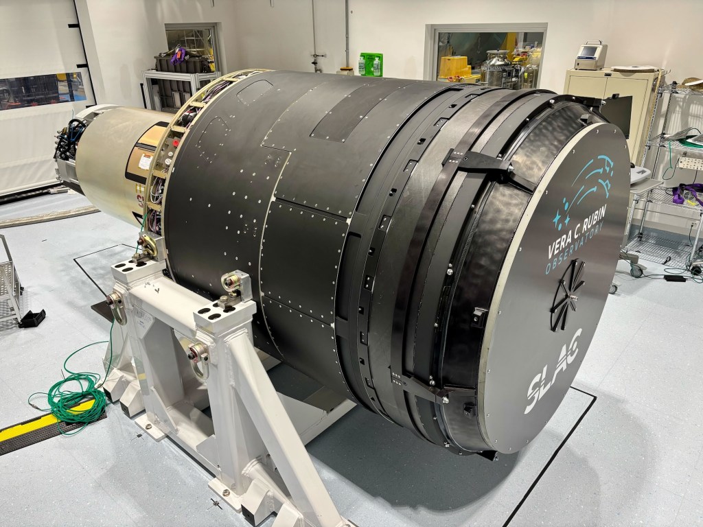
Now fully assembled atop Chile’s Cerro Pachón, the Vera C. Rubin Observatory is beginning its incredible and ambitious mission. Today’s presser focused on unveiling the first images captured by its groundbreaking camera, offering an early glimpse of the observatory’s vast potential. At the heart of the facility is SLAC’s creation: the world’s largest digital camera, a 3.2-gigapixel behemoth developed by the U.S. Department of Energy.
This extraordinary instrument is the central engine of the Legacy Survey of Space and Time (LSST), a decade-long sky survey designed to study dark energy, dark matter, and the changing night sky with unprecedented precision and frequency. We are essentially creating a decade-long time-lapse of the universe in detail that has never been captured before, revealing the dynamic cosmos in ways previously impossible. Over the course of ten years, it will catalog 37 billion individual astronomical objects, returning to observe each one every three nights to monitor changes, movements, and events across the sky. I want to learn more about how Artificial Intelligence and machine learning are being brought to bear to help scientists understand what they are seeing.
The camera, over 5 feet tall and weighing about three tons, took more than a decade to build. Its focal plane is 64 cm wide-roughly the size of a small coffee table-and consists of 189 custom-designed charge-coupled devices (CCDs) stitched together in a highly precise mosaic. These sensors operate at cryogenic temperatures to reduce noise and can detect the faintest cosmic light, comparable to spotting a candle from thousands of miles away.
The LSST Camera was moved from the summit clean room and attached to the camera rotator for the first time in February 2025. (Credit: RubinObs/NOIRLab/SLAC/DOE/NSF/AURA)
Rubin’s camera captures a massive 3.5-degree field of view-more than most telescopes can map in a single shot. That’s about seven times the area of the full moon. Each image takes just 15 seconds to capture and only two seconds to download. A single Rubin image contains roughly as much data as all the words The New York Times has published since 1851. The observatory will generate about 20 terabytes of raw data every night, which will be transmitted via a high-speed 600 Gbps link to processing centers in California, France, and the UK. The data will then be routed through SLAC’s U.S. Data Facility for full analysis.
The complete focal plane of the future LSST Camera is more than 2 feet wide and contains 189 individual sensors that will produce 3,200-megapixel images. Crews at SLAC have now taken the first images with it. Explore them in full resolution using the links at the bottom of the press release. (Credit: Jacqueline Orrell/SLAC National Accelerator Laboratory)
The images produced will be staggering in both detail and scale. Each exposure will be sharp enough to reveal distant galaxies, supernovae, near-Earth asteroids, and other transient cosmic phenomena in real time. By revisiting the same patches of sky repeatedly, the Rubin Observatory will produce an evolving map of the dynamic universe-something no previous observatory has achieved at this scale.
What sets Rubin apart from even the giants like Hubble or James Webb is its speed, scope, and focus on change over time. Where Hubble peers deeply at narrow regions of space and Webb focuses on the early universe in infrared, Rubin will cast a wide and persistent net, watching the night sky for what moves, vanishes, appears, or explodes. It’s designed not just to look, but to watch. Just imaging the kind of stuff we will see!
The LSST Camera’s imaging sensors are grouped into units called “rafts.” Twenty-one square rafts, each with nine sensors, will capture science images, while four smaller rafts with three sensors each handle focus and telescope alignment. (Credit: Farrin Abbott/SLAC National Accelerator Laboratory)
This means discoveries won’t just be about what is out there, but what happens out there. Astronomers expect Rubin to vastly expand our knowledge of dark matter by observing how mass distorts space through gravitational lensing. It will also help map dark energy by charting the expansion of the universe with unprecedented precision. Meanwhile, its real-time scanning will act as a planetary defense system, spotting potentially hazardous asteroids headed toward Earth.
But the magic lies in the possibility of the unexpected. Rubin may detect rare cosmic collisions, unknown types of supernovae, or entirely new classes of astronomical phenomena. Over ten years, it’s expected to generate more than 60 petabytes of data-more than any other optical astronomy project to date. Scientists across the globe are already preparing for the data deluge, building machine learning tools to help sift through the torrent of discovery.
And none of it would be possible without SLAC’s camera. A triumph of optics, engineering, and digital sensor technology, the camera is arguably one of the most complex and capable scientific instruments ever built. I don’t care if you’re a Canon or a Sony person, this is way beyond all that. It’s a monument to what happens when curiosity meets collaboration, with California’s innovation engine powering the view.
As first light filters through the Rubin Observatory’s massive mirror and into SLAC’s camera, we are entering a new era of astronomy-one where the universe is not just observed, but filmed, in exquisite, evolving detail. This camera won’t just capture stars. It will reveal how the universe dances.
I recently took two scuba diving trips out to the Channel Islands to investigate and help remove ghost lobster traps: abandoned or lost gear that poses a serious threat to marine life. While out there, I also had a chance to explore the marine protected areas surrounding Anacapa and Santa Cruz Islands, getting a firsthand look at how these underwater reserves are helping to restore ocean health and marine life (another story on that coming). Diving in the Channel Islands is a great way for certified divers to experience the incredible biodiversity of California’s coastal waters, even if the water is cold as hell.
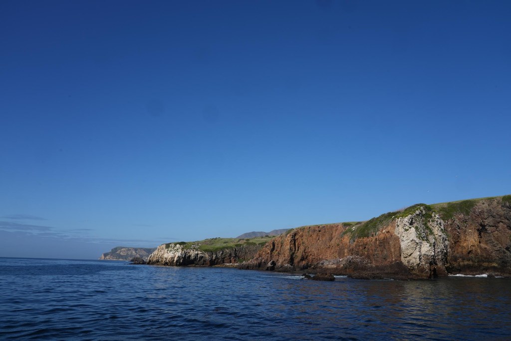
The Channel Islands are actually relatively close to the California mainland, just 12 miles from Ventura in the case of Anacapa. But the wild and windswept chain feels like a world apart. On a clear day, you can see them from Ventura or Santa Barbara, but oddly, few people actually visit. Compared to other national parks, they remain relatively unknown, which only adds to their quiet allure. Sometimes called the “Galápagos of North America,” these eight islands are a refuge for wildlife and a place where evolution unfolds before your eyes.
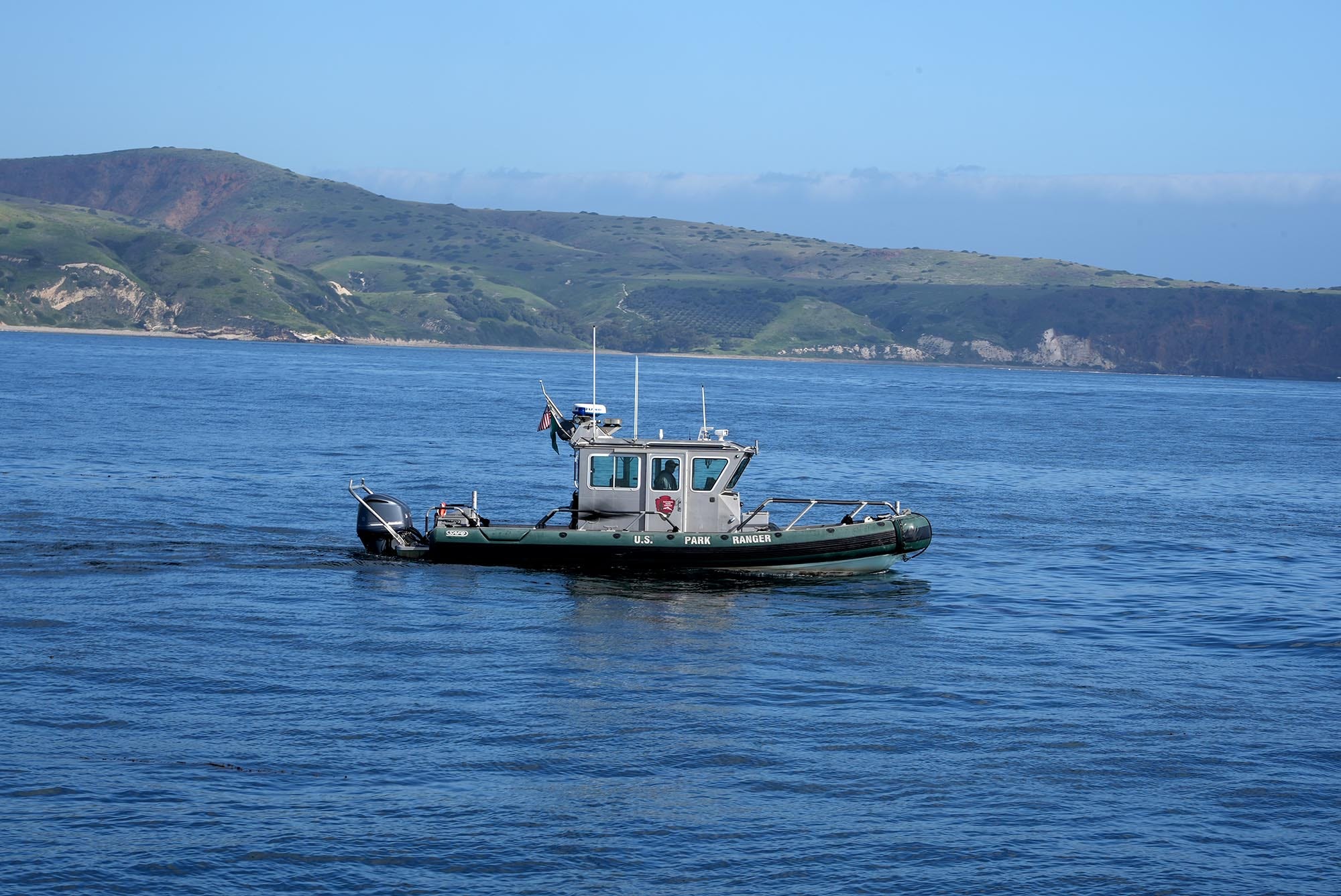
U.S. Park Service rangers patrol the marine protected area off of Anacapa Island in California’s Channel Islands (Photo: Erik Olsen)
(Here’s a cool bit of history: there are eight Channel Islands today, but 20,000 years ago, during the last ice age when sea levels were much lower, four of them—San Miguel, Santa Rosa, Santa Cruz, and Anacapa—were connected as a single landmass called Santarosae.)
For scientists and nature lovers, the Channel Islands are more than just scenic, they’re a natural laboratory. Each island has its own shape, size, and ecological personality, shaped by millions of years of isolation. That makes them an ideal setting for the study of island biogeography, the branch of biology that looks at how species evolve and interact in isolated environments. What happens here offers insight into how life changes and adapts not just on islands, but across the planet.
Sea lions on the Channel Islands (NPS)
Island biogeography is anchored in the theory proposed by E.O. Wilson and Robert MacArthur in the 1960s. Their theory, focusing on the balance between immigration and extinction of species on islands, is brilliantly exemplified in the Channel Islands.
The Channel Islands’ rich mosaic of habitats, from windswept cliffs and rocky shores to chaparral-covered hillsides and dense offshore kelp forests, provides an ideal setting for studying how species adapt to varied and changing conditions. Each island functions like a separate ecological experiment, shaped by isolation, resource limits, and time. Evolution has had free rein here, tweaking species in subtle ways and, occasionally, producing striking changes.
One of the most significant studies conducted in the Channel Islands focused on the island fox (Urocyon littoralis), a species found nowhere else on Earth. Research led by the late evolutionary biologist Robert Wayne at UCLA and others showed that the fox populations on each of the six islands they inhabit have evolved in isolation, with distinct genetic lineages and physical traits. This makes them a remarkable example of rapid evolution and adaptive divergence, core processes in island biogeography.
Genetic analyses revealed that each island’s fox population carries unique genetic markers, shaped by long-term separation and adaptation to local environments. These differences aren’t just genetic, they’re physical and behavioral too. Foxes on smaller islands, for instance, tend to be smaller in body size, likely an evolutionary response to limited resources, a phenomenon known as insular dwarfism. Variations in diet, foraging behavior, and even coat coloration have been documented, offering scientists an unparalleled opportunity to study evolutionary processes in a real-world, relatively contained setting.
Excavation of pygmy mammoth bones on the Channel Islands (Photo: National Park Service)
This phenomenon of insular dwarfism isn’t unique to the island fox. One of the most striking examples from the Channel Islands is the pygmy mammoth (Mammuthus exilis), whose fossilized remains were discovered on Santa Rosa Island. Evolving from the much larger Columbian mammoth, these ancient giants shrank to about half their original size after becoming isolated on the islands during the last Ice Age. Limited food, reduced predation, and restricted space drove their dramatic transformation, a powerful illustration of how isolation and environmental pressures can reshape even the largest of species.
Furthermore, the Channel Islands have been instrumental in studying plant species’ colonization and adaptation. Due to their isolation, the islands host a variety of endemic plant species. Research by Kaius Helenurm, including genetic studies on species such as the Santa Cruz Island buckwheat (Eriogonum arborescens) and island mallow (Malva assurgentiflora), has shown how these plants have adapted to the islands’ unique environmental pressures and limited gene flow.
Island mallow (Malva assurgentiflora), a vibrant flowering plant found only on the Channel Islands, thrives in the harsh coastal environment—its striking blooms a testament to the power of isolation and adaptation. (Photo: Curtis Clark)
The islands have been a scientific boon to researchers over the decades because they are not only home to many diverse and endemic species, but their proximity to the urban centers and the universities of California make them amazingly accessible. It’s been suggested that if Darwin had landed on the Channel Islands, he arguably could have come up with the theory of natural selection off of California, rather than happening upon the Galapagos. A 2019 book about the islands, titled North America’s Galapagos: The Historic Channel Islands Biological Surveyrecounts the story of a group of researchers, naturalists, adventurers, cooks, and scientifically curious teenagers who came together on the islands in the late 1930s to embark upon a series of ambitious scientific expeditions never before attempted.
The Channel Islands are renowned for their high levels of endemism — species that are found nowhere else in the world. This is a hallmark of island biogeography, as isolated landmasses often lead to the development of unique species. Darwin’s On the Origin of Species was one of the first extensive efforts to describe this phenomenon. For example, as mentioned above, the Channel Islands are home to the island fox (Urocyon littoralis), a small carnivore found only here. Each island has its own subspecies of the fox, differing slightly in size and genetics, a striking example of adaptive radiation, where a single species gives rise to multiple different forms in response to isolation and environmental pressures. That said, the foxes are also incredibly cute, but can be rather annoying if you are camping on the islands because they will ransack your food stores if you do not keep them tightly closed.
Island Fox on Santa Cruz Island (photo: Erik Olsen)
Bird life on the Channel Islands also reveals remarkable diversity and endemism. Much like the finches of the Galápagos, these islands are home to distinct avian species shaped by isolation and adaptation. The Santa Cruz Island Scrub Jay, for instance, is noticeably larger and more vividly colored than its mainland relatives, a reflection of its unique island habitat. Also, jays in pine forests tend to have longer, shallower bills, while those in oak woodlands have shorter, deeper bills. Evolutionary adaptations right out of the Darwinian playbook. Likewise, the San Clemente House Finch has evolved traits suited to its specific environment, illustrating how even common species can diverge dramatically when given time and separation.
The Island Scrub-Jay (Aphelocoma insularis), found only on Santa Cruz Island, is larger and more vividly colored than its mainland cousin—an unmistakable symbol of how isolation shapes evolution. (Photo: National Park Service)
The impacts of invasive species on island ecosystems, another critical aspect of island biogeography, are also evident in the Channel Islands. The islands have been an superb laboratory for the practice of conservation and human-driven species recovery. For example, efforts to remove invasive species, like pigs and rats, and the subsequent recovery of native species, like the island fox, provide real-time insights into ecological restoration and the resilience of island ecosystems.
These efforts at conservation and species recovery extend beyond the island fox. In 1997, the U.S. Fish and Wildlife Service identified that 13 plant species native to the northern Channel Islands in California were in dire need of protection under the Endangered Species Act. This need arose due to several decades of habitat degradation, primarily attributed to extensive sheep grazing. These conservation efforts have yielded good news. For instance, the island bedstraw (Galium buxifolium) expanded from 19 known sites with approximately 500–600 individuals in 1997 to 42 sites with over 15,700 individuals. Similarly, the Santa Cruz Island dudleya (Dudleya nesiotica) population stabilized at around 120,000 plants. As a result of these recoveries, both species were removed from the federal endangered species list in 2023, coinciding with the 50th anniversary of the Endangered Species Act.
Santa Cruz Island Dudleya (Photo: National Park Service)
Conservation efforts at the Channel Islands extend beneath the waves, where marine protected areas (MPAs) have played a crucial role in restoring the rich biodiversity of the underwater world. I’ve seen the rich abundance of sea life firsthand on several dives at the Channel Islands, where the biodiversity feels noticeably greater than at many mainland dive sites in Southern California.
The Channel Islands Marine Protected Areas (MPAs), established in 2003, were among the first of their kind in California. The MPAs around Anacapa, Santa Cruz, and other islands act as refuges where fishing and other extractive activities are limited or prohibited, allowing marine ecosystems to recover and thrive. Over the past two decades, scientists have documented increases in the size and abundance of key species such as kelp bass, lobsters, and sheephead, alongside the resurgence of lush kelp forests that anchor a vibrant web of marine life. These protections have not only benefited wildlife but have also created living laboratories for researchers to study ecological resilience, predator-prey dynamics, and the long-term impacts of marine conservation, all taking place in the context of island biogeography.
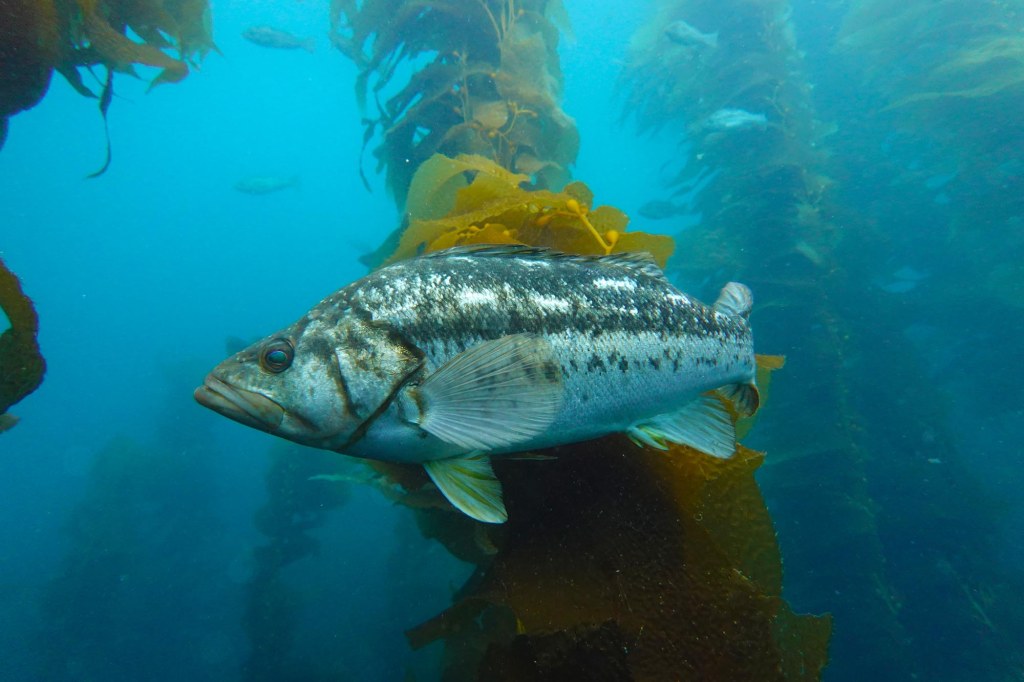
Kelp bass in the kelp forest at the Channel Islands (Photo: Erik Olsen)
What makes all of this possible is the remarkable decision to keep these islands protected and undeveloped. Unlike much of the California coast, the Channel Islands were set aside, managed by the National Park Service and NOAA as both a national park and a marine sanctuary. These protections have preserved not just the landscapes, but the evolutionary stories still unfolding in real time. It’s a rare and precious thing to have a living laboratory of biodiversity right in our backyard, and a powerful reminder of why preserving wild places matters.
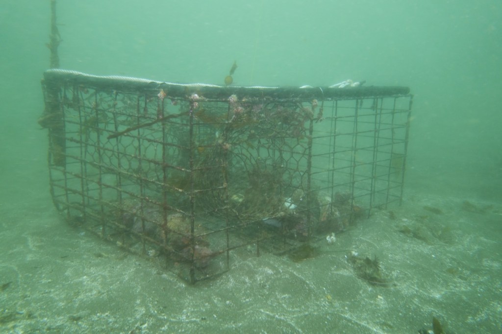
Ghost lobster trap off Santa Cruz Island in California’s Channel Islands (Photo: Erik Olsen)
Lobster is delicious. Let’s just get that out of the way. Yes, I’m sure there are some who either don’t enjoy the taste of this prolific crustacean, or who are allergic, but for my part, lobster (with a small vial of melted butter) is ambrosia from the sea.
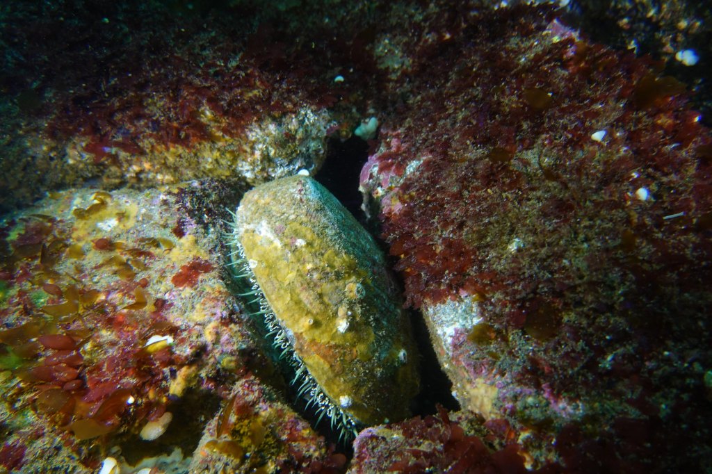
But beyond its place on the plate, the California spiny lobster plays a vital ecological role: hunting sea urchins, hiding in rocky reefs, and helping to keep kelp forests in balance. Its value extends far beyond what it fetches at market. But beneath the surface, particularly around the Channel Islands lurks a growing problem that doesn’t just threaten lobsters. It threatens the entire marine ecosystem: ghost traps.
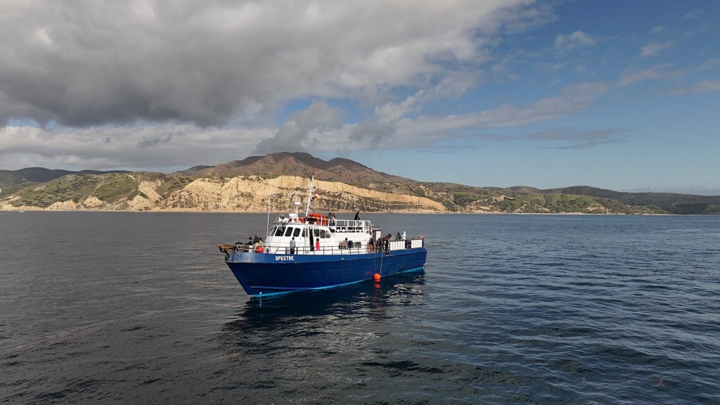
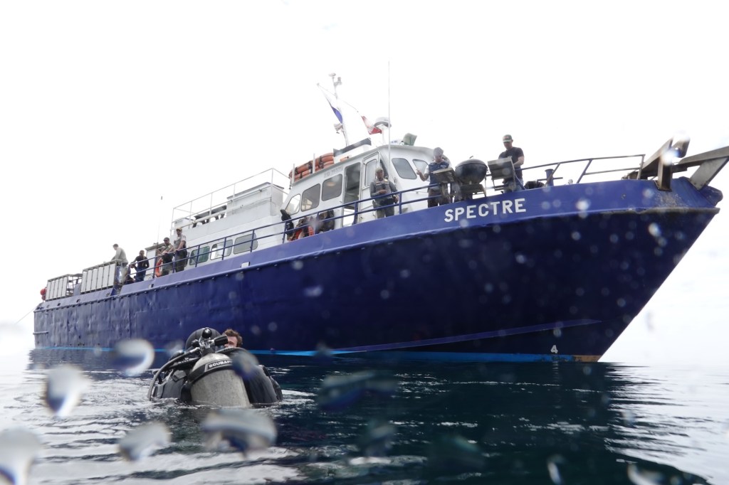
Dive ship Spectre off of Anacapa Island in California’s Channel Islands (Photo: Erik Olsen)
In Southern California, lobster fishing is both a cultural tradition and a thriving industry, worth an estimated $44 million annually to California’s economy from commercial landings as well as recreational fishing, tourism, and seafood markets.
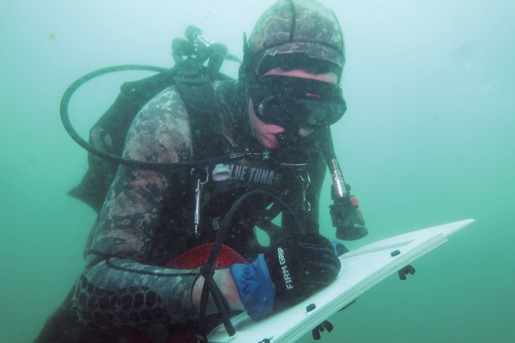
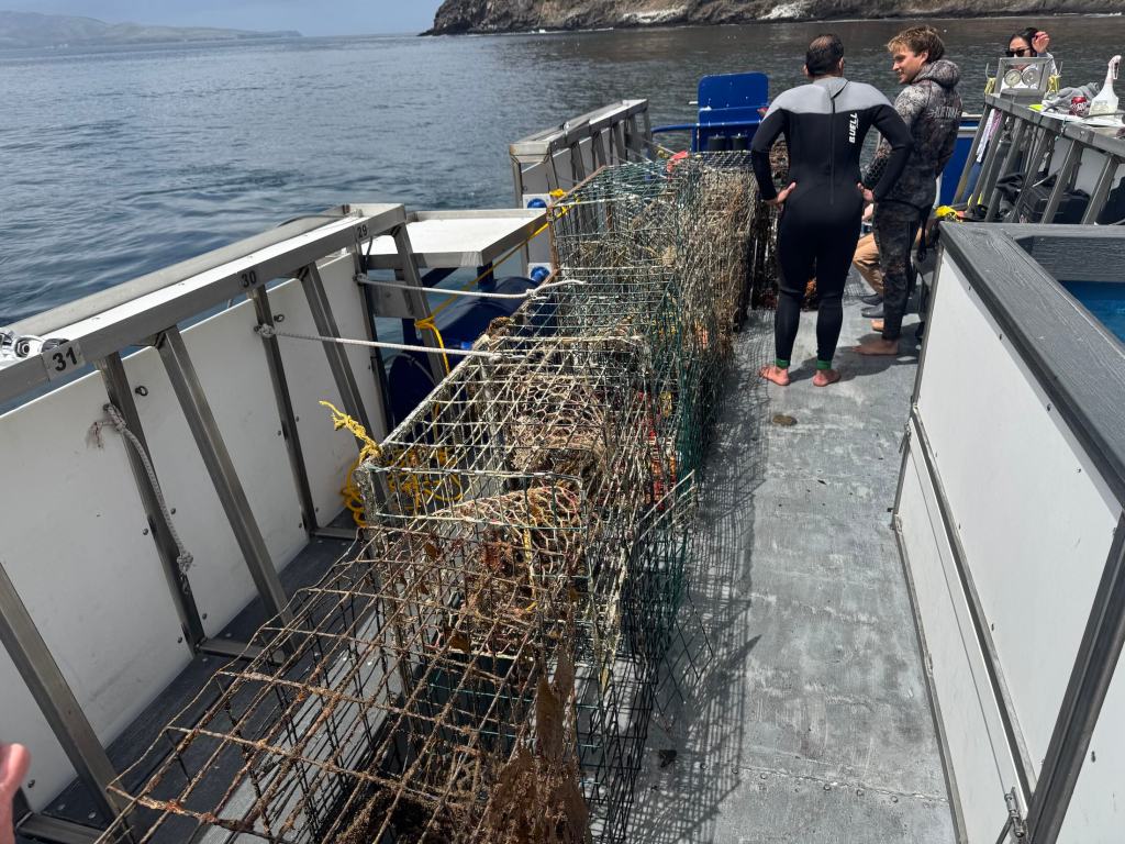
In late April, I traveled to the Channel Islands with my colleague Tod Mesirow to see the problem of ghost lobster traps firsthand. We were aboard the Spectre dive ship and pulled out of Ventura Harbor on an overcast morning, the sky a uniform gray that blurred the line between sea and cloud. The swell was gentle, but the air carried a sense of anticipati on. We were invited by the Benioff Ocean Science Laboratory, which is conducting research and outreach in the area. Our visit took us to Anacapa and Santa Cruz Islands, where I would be diving to observe the traps littering the sea floor. Tod, meanwhile, remained topside, capturing footage and speaking with marine scientists. Even before entering the water, we could see the toll: frayed lines tangled in kelp, buoys adrift, and entire areas where dive teams had marked clusters of lost gear.
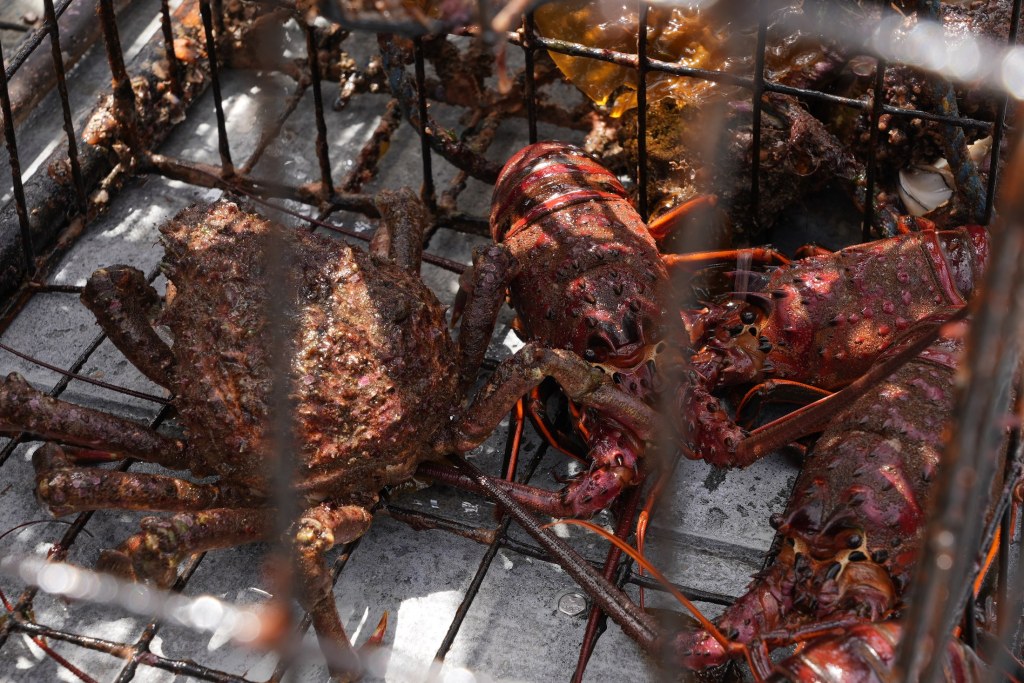
California spiny lobsters alive when the ghost trap was recovered (Photo: Erik Olsen)
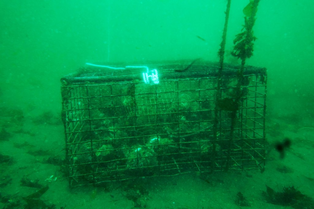
Ghost traps are lobster pots that have been lost or abandoned at sea. Made of durable metal mesh and often outfitted with bait containers and strong ropes, these traps are built to last. And they do. For years. Sometimes decades. The problem is, even when their human operators are long gone, these traps keep fishing.
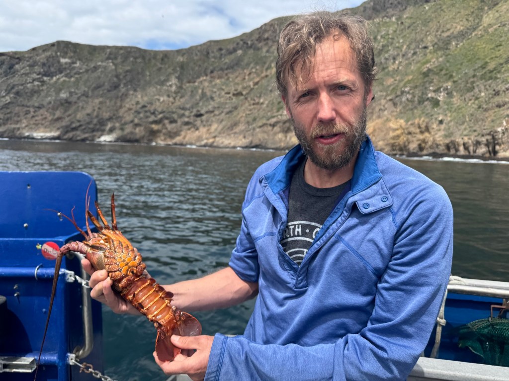
“It’s not uncommon to find multiple animals dead inside a single trap,” said Douglas McCauley, a marine science professor at UC Santa Barbara and director of the Benioff Ocean Science Laboratory who was onboard with us and leading the project. “It’s heartbreaking. These traps are still doing exactly what they were built to do, just without anyone coming back to check them.”
Douglas McCauley, director of the Benioff Ocean Science Laboratory at the University of California Santa Barbara holding a lobster caught in a ghost trap off the coast of the Channel Islands (Photo: Erik Olsen)
Around the Channel Islands National Marine Sanctuary, where fishing pressure is high and waters can be rough, thousands of traps are lost every season. Currents, storms, or boat propellers can sever buoys from their lines, leaving the traps invisible and unrecoverable. Yet they keep doing what they were designed to do: lure lobsters and other sea creatures inside, where they die and become bait for the next unfortunate animal. It’s a vicious cycle known as “ghost fishing.”
“They call them ghost traps because, like a ghost sailing ship, they keep doing their thing. They keep fishing.” said McCauley.
Statewide, the numbers are staggering. Approximately 6,500 traps are reported lost off the California coast each fishing season, according to The California Department of Fish and Wildlife. The folks at the Benioff Ocean Science Laboratory said as many as 6,000 may lie off the coast of the Channel Islands alone. Ocean Divers removing marine debris have found traps stacked three and four high in underwater ravines—rusting, tangled, but still deadly. These ghost traps don’t just catch lobsters; they also trap protected species like sheephead, cabezon, octopuses, and even the occasional sea turtle or diving seabird.
Diver and Project Scientist Chase Brewster of the Benioff Ocean Science Laboratory collecting data on ghost lobster traps near California’s Channel Islands (Photo: Erik Olsen)
Nowhere is this more evident than around the Channel Islands. These rugged islands are home to some of California’s richest kelp forests and underwater canyons. The islands and their surrounding waters are home to over 2,000 plant and animal species, with 145 of them being unique to the islands and found nowhere else on Earth. In fact, the Channel Islands are often referred to as North America’s Galapagos for the immense diversity of species here.
The islands are also the site of the state’s most productive spiny lobster fisheries. Every fall, hundreds of commercial and recreational fishers flood the area, setting thousands of traps in a race to catch California spiny lobsters (Panulirus interruptus). But rough swells and heavy gear mean traps go missing. Boats sometimes cut the lines of traps, making them near impossible to retrieve from the surface. And because this region is a patchwork of state waters, federal waters, and marine protected areas (MPAs), cleanup and regulation are anything but straightforward.
California Spiny Lobster off Anacapa Island (Photo: Erik Olsen)
The traps are often difficult to locate, partly because of their remote placement and the notoriously rough waters around the Channel Islands. But the Benioff Ocean Science Laboratory has a powerful asset: side scan sonar. From the ship, they can scan and map the seafloor, where the ghost traps often appear as dark, rectangular shapes against the sand. Once spotted, the team uses GPS to log their exact location.
“It’s creates a picture made of sound on the seafloor and you see these large lego blocks staring at you in bright yellow on the screen and those are your lobster traps,” sayd McCauley. “There’s nothing else except a ghost trap that looks like that.”
Plunging into the frigid waters off Santa Cruz Island was a jolt to the system. Visibility was limited, just 10 to 15 feet, but I followed two scientists from the Benioff Ocean Science Laboratory down to a depth of 45 feet. Their task: to attach a rope to the trap so it could be hauled up by the boat’s winch.
Dive ship Spectre off the coast of Santa Cruz Island in California’s Channel Islands (Photo: Erik Olsen)
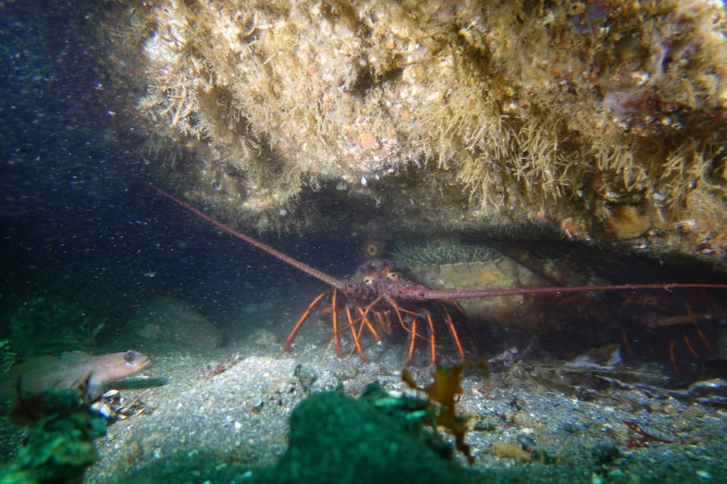
The water was thick with suspended particles, the light dimming quickly as we dropped lower. My 7mm wetsuit was just barely enough to stave off the cold. On the seafloor, the ghost trap emerged, a large rectangular cage resting dark and ominous in the sand. And it was teeming with life. Fish darted around its edges, lobsters clambered along the frame, and inside, several animals moved about, trapped and slowly dying. It was easy to see how a single trap could wreak quiet havoc for years.
California law technically requires all lobster traps to include biodegradable “escape panels” with zinc hinges that degrade over time, eventually allowing trapped animals to escape. But enforcement is tricky, and the panels don’t always work as intended. In practice, many traps, especially older or illegally modified ones, keep fishing long after they should have stopped. That’s what we were out here to find.
A baby octopus caught in a ghost trap in the waters off California’s Channel Islands (Photo: Erik Olsen)
Complicating matters is the fact that once a trap goes missing, there’s no easy way to retrieve it. Fishers are not legally allowed to touch traps that aren’t theirs, even if they’re obviously abandoned. And while a few small nonprofits and volunteer dive teams conduct periodic ghost gear removal missions, they can’t keep pace with the scale of the problem.
“At this fishery, we can’t get them all,” says McCauley. “But by going through and getting some species out and getting them back in the water, we’re making a difference. But in the process, we’re coming up with new ideas, new technologies, new research methods, which we think could play a role in and actually stopping this problem in the first instance.”
Once abundant along California’s coast, this large abalone spotted off Santa Cruz Island is a rare sight today—a quiet reminder of how overfishing, disease, and environmental change have decimated their populations. (Photo: Erik Olsen)
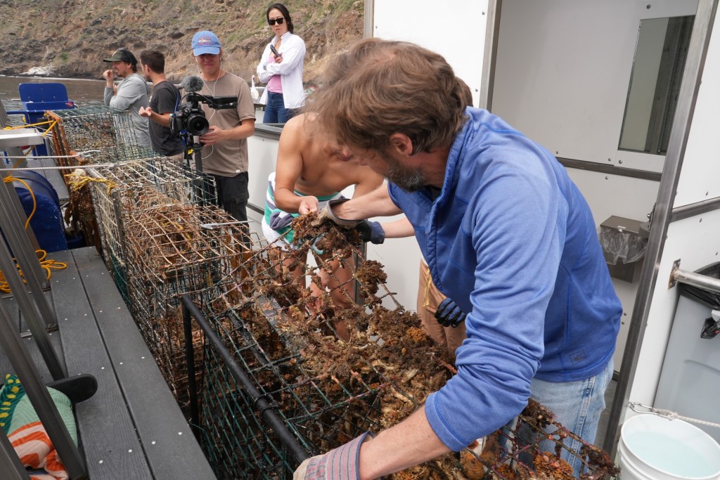
Back topside, the recovery team aboard the Spectre used a powerful hydraulic winch to haul the trap onto the deck. After climbing out of the cold water, still shivering, I joined the others to get a closer look. The trap was heavy and foul-smelling, but what stood out most was what was inside: lobsters, maybe ten or more. Some had perished, but many were alive and thrashed their tails when lifted by the scientists. Females could be identified by their broader, flatter tail fins—adapted to hold eggs. The team carefully measured each one before tossing them back into the sea, the lobsters flipping backward through the air and disappearing into the depths.
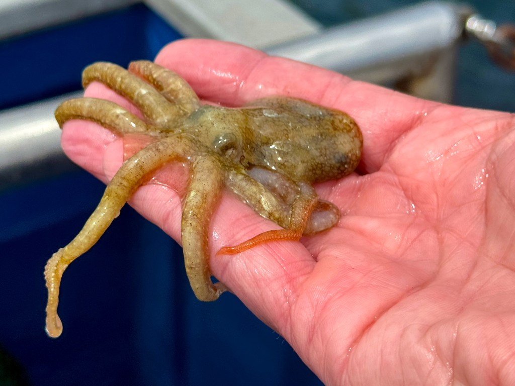
There were other animals, too. Large, rounded crabs known as Sheep crabs, common to these waters, scuttled at the bottom of the trap. Sea snails were clustered along the mesh, and in one cage, there were dozens of them, clinging and crawling with slow purpose. Even baby octopuses made appearances, slithering out onto the deck like confused aliens. I picked one up gently, marveling at its strange, intelligent eyes and soft, shifting forms, before tossing it back into the sea in hopes it would have another chance at life.
Ghost lobster trap lies on the seafloor off of Santa Cruz Island in California’s Channel Islands (Photo: Erik Olsen)
By then, the day had brightened and the sun had come out, easing the chill that lingered after the dive. The traps would be taken back to Ventura, where they’d likely be documented and disposed of. But this day wasn’t just about saving individual animals or pulling traps off the seafloor—it was about data. The Benioff team wants to understand just how big of a problem ghost traps really are. It’s not just about the number of traps lost each season, but the broader ecological toll: how many animals get caught, how many die, and how these traps alter the underwater food web. Every recovered trap adds a piece to the puzzle. This trip was about science as much as rescue.
State agencies, including the California Department of Fish and Wildlife (CDFW), have started pilot programs aimed at tackling ghost gear. In 2023, CDFW launched a limited recovery permit program that allows fishers to collect derelict traps at the end of the season, provided they notify the state. But participation is voluntary and poorly funded.
Elsewhere, states like Maine and Florida have created large-scale, state-funded programs to identify and remove ghost traps, often employing fishers in the off-season. California, despite having the nation’s fourth-largest lobster fishery, has yet to make a similar investment.
Ghost lobster traps recovered from the seafloor off the coast of California’s Channel Islands (Photo: Erik Olsen)
Some solutions are already within reach. Mandating GPS-equipped buoys for commercial traps could help track and retrieve gear before it’s lost. More robust escape hatch designs, made from materials that dissolve in weeks rather than months, would shorten the lifespan of a lost trap. And expanding retrieval programs with funding from fishing license fees or federal grants could make a big dent in ghost gear accumulation.
But even more powerful than regulation may be public awareness. Ghost traps are out of sight, but their damage is far from invisible. Every trap left behind in the Channel Islands’ waters becomes another threat to biodiversity, another source of plastic and metal waste, and another reminder that marine stewardship doesn’t stop when the fishing season ends.
Key to the whole effort is data:
“Every one of the animals that we put back in the water today, we’ll be taking a measure,” says McCauley. “After a little bit of crunching in the lab, we’ll be able to say, oh, actually, you know, every single trap undercuts the fishery by x percent for every single year that we don’t solve the problem.”
Doug McCauley with a lobster trap retrieved from the seafloor off the coast of California’s Channel Islands (Photo: Erik Olsen)
As we headed back toward Ventura, Tod and I talked with Douglas McCauley and Project Scientist Neil Nathan from the Benioff Ocean Science Laboratory. The team had collected a total of 13 traps that day alone, and 34 over the several days they’d been out. There was a sense of satisfaction on board, quiet but real. Each trap removed was a small win for the ecosystem, a little less pressure on an already strained marine environment.
“I would call today an incredible success, ” said Neil Nathan. “Feeling great about the number of traps we collected.”
California has long been a leader in ocean conservation. If it wants to stay that way, it needs to take ghost fishing seriously, not just around the Channel Islands, but up and down the coast. After all, we owe it to the lobsters, yes, but also to the underwater forests, reef communities, and countless species whose lives are tangled in the nets we leave behind.
We wrote a piece a while back about the three winters Albert Einstein spent in Pasadena, a little-known chapter in the life of a man who changed how we understand the universe. It was our way of showing how Einstein, often seen as a figure of European academia and global science, formed a real affection for California and for Pasadena in particular. It’s easy to picture him walking the streets here, lost in thought or sharing a laugh with Charlie Chaplin. The idea of those two geniuses, one transforming physics and the other revolutionizing comedy, striking up a friendship is something worth imagining.
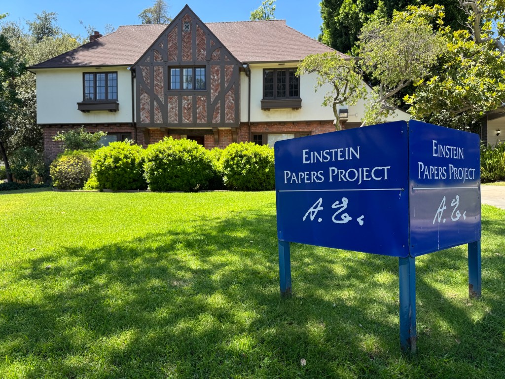
But Einstein’s connection to Pasadena didn’t end there. It lives on in a small, nondescript building near the Caltech campus, where a group of researchers continues to study and preserve the legacy he left behind.
The Einstein Papers Project (EPP) at Caltech is one of the most ambitious and influential scientific archival efforts of the modern era. It’s not just about preserving Albert Einstein’s work—it’s about opening a window into the mind of one of the most brilliant thinkers in history. Since the late 1970s, a dedicated team of scholars has been working to collect, translate, and annotate every significant document Einstein left behind. While the project is headquartered at the California Institute of Technology, it collaborates closely with Princeton University Press and the Hebrew University of Jerusalem, which houses the original manuscripts.
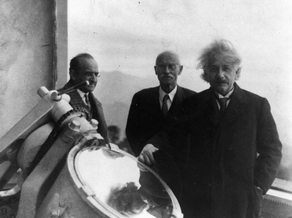
Einstein at the Santa Barbara home of Caltech trustee Ben Meyer on Feb. 6, 1933. (The Caltech Archives)
The idea began with Harvard physicist and historian Gerald Holton, who saw early on that Einstein’s vast output—scientific papers, personal letters, philosophical musings—deserved a meticulously curated collection. That vision became the Einstein Papers Project, which has since grown into a decades-long effort to publish The Collected Papers of Albert Einstein, now spanning over 15 volumes (and counting). The project’s goal is as bold as Einstein himself: to assemble a comprehensive record of his life and work, from his earliest student notebooks to the letters he wrote in the final years of his life.
Albert Einstein and Charlie Chaplin during the premiere of the film ‘City Lights’. (Wikipedia)
Rather than being stored in a traditional library, these documents are carefully edited and presented in both print and online editions. And what a treasure trove it is. You’ll find the famous 1905 “miracle year” papers that revolutionized physics, laying the foundation for both quantum mechanics (which Einstein famously derided) and special relativity. You’ll also find handwritten drafts, scribbled calculations, and long chains of correspondence—sometimes with world leaders, sometimes with lifelong friends. These documents don’t just chart the course of scientific discovery; they reveal the very human process behind it: doubt, revision, flashes of inspiration, and stubborn persistence.
At the Mount Wilson Observatory with the Austrian mathematician Walther Mayer, left, and Charles St. John of the observatory staff. (The Caltech Archives)
Some of the most fascinating material involves Einstein’s attempts at a unified field theory, an ambitious effort to merge gravity and electromagnetism into one grand framework. He never quite got there, but his notebooks show a mind constantly working, refining, rethinking—sometimes over decades.
But the project also captures Einstein the person: the political thinker, the pacifist, the refugee, the cultural icon. His letters reflect a deep concern with justice and human rights, from anti-Semitism in Europe to segregation in the United States. He corresponded with Sigmund Freud about the roots of violence, with Mahatma Gandhi about nonviolent resistance, and with presidents and schoolchildren alike. The archive gives us access to the full spectrum of who he was, not just a scientist, but a citizen of the world.
The Einstein Papers Project home near Caltech in Pasadena (Photo: Erik Olsen)
One of the most exciting developments has been the digitization of the archive. Thanks to a collaboration with Princeton University Press, a large portion of the Collected Papers is now freely available online through the Digital Einstein Papers website. Students, teachers, historians, and science nerds around the globe can now browse through Einstein’s original documents, many of them translated and annotated by experts. The most recent release, Volume 17, spans June 1929 to November 1930, capturing Einstein’s life primarily in Berlin as he travels across Europe for scientific conferences and to accept honorary degrees. The volume ends just before his departure for the United States. Princeton has a nice story on the significance of that particular volume by EPP Editor Josh Eisenthal.
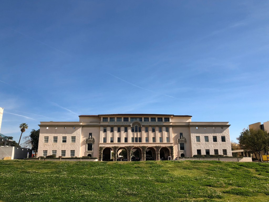
The California Institute of Technology, CalTech (Photo: Erik Olsen)
For scholars, the project is a goldmine. It’s not just about Einstein—it’s about the entire intellectual climate of the 20th century. His collaborations and rivalries, his responses to global upheaval, and his reflections on science, faith, and ethics all provide insight into a remarkable era of discovery and change. His writings also show a playful, curious side—his love of music, his wit, and his habit of thinking in visual metaphors.
Caltech’s role in all this goes beyond simple stewardship. The Einstein Papers Project is a reflection of the institute’s broader mission: to explore the frontiers of science and human understanding. For decades, Caltech has been a breeding ground for great minds. As of January 23, 2025, there are 80 Nobel laureates who have been affiliated with Caltech, making it the institution with the highest number of Nobelists per capita in America. By preserving and sharing Einstein’s legacy, Caltech helps keep alive a conversation about curiosity, responsibility, and the enduring power of ideas.
Before the late 1960s, understanding Earth’s shifting surface, particularly in a geologically active region like California, was a major scientific challenge. For most of human history, the causes of earthquakes remained an enigma—mysterious and terrifying, often attributed to supernatural forces. In Japan, for example, earthquakes were traditionally believed to be caused by Namazu, a giant catfish said to live beneath the earth and whose thrashing would shake the land. Many societies believed earthquakes were divine punishments or omens, while others considered them an essential part of creation, events necessary to form a world habitable by us humans.
The complexity of California’s landscape, its mountains, valleys, deserts, and intricate network of faults, posed difficulties for early geologists. The land appeared chaotically interwoven, with many different types of rock making up the gaping deserts and soaring peaks. As the great University of California at Davis geologist Eldridge Moores once put it, “Nature is messy. Don’t expect it to be uniform and consistent.”
An image of humans battling a Namazu (Credit: Tokyo University Library. Public Domain)
But there was no overarching explanation for how these earthly features got there. Scientists could observe and record earthquakes, but without a unifying theory, they struggled to piece together the deeper mechanisms driving these powerful events.
This frustration lingered until the late 1960s when an intellectual revolution in geology took shape. Despite the dawn of the space age and the rise of computing power, many earth scientists still clung to the belief that the continents were fixed, immovable features on the Earth’s surface. The breakthrough came with the acceptance of plate tectonics—a theory that elegantly explained not just earthquakes, but the entire dynamic nature of Earth’s surface. And for many geologists, the moment this new understanding solidified was in December 1969, at a groundbreaking conference at the Asilomar Conference Center in California that reshaped the future of the field. (Notably, Asilomar was also the site of the historic 1975 conference on recombinant DNA, where scientists gathered to establish ethical guidelines for genetic research, an event we have explored previously.) This was the moment when plate tectonics, a concept that would fundamentally reshape our view of the planet, truly took hold in the Western American geological community.
At California’s Asilomar Conference Grounds, nestled amid Monterey pines and dramatic granite formations, scientists gathered to rewrite our understanding of tectonics—and reshape how we think about Earth’s restless surface. (Erik Olsen)
For centuries, explanations for Earth’s features ranged from catastrophic events to gradual uplift and erosion, a debate that became known as uniformitarianism versus catastrophism. In California, the sheer complexity of the geology, with its links go far beyond the borders of the state, hinted at powerful forces at play. Scientists grappled with the origins of the Sierra Nevada, the formation of the Central Valley, and the persistent threat of earthquakes along the now-famous San Andreas Fault. The prevailing models, however, lacked the comprehensive framework to connect these disparate observations into a coherent narrative.
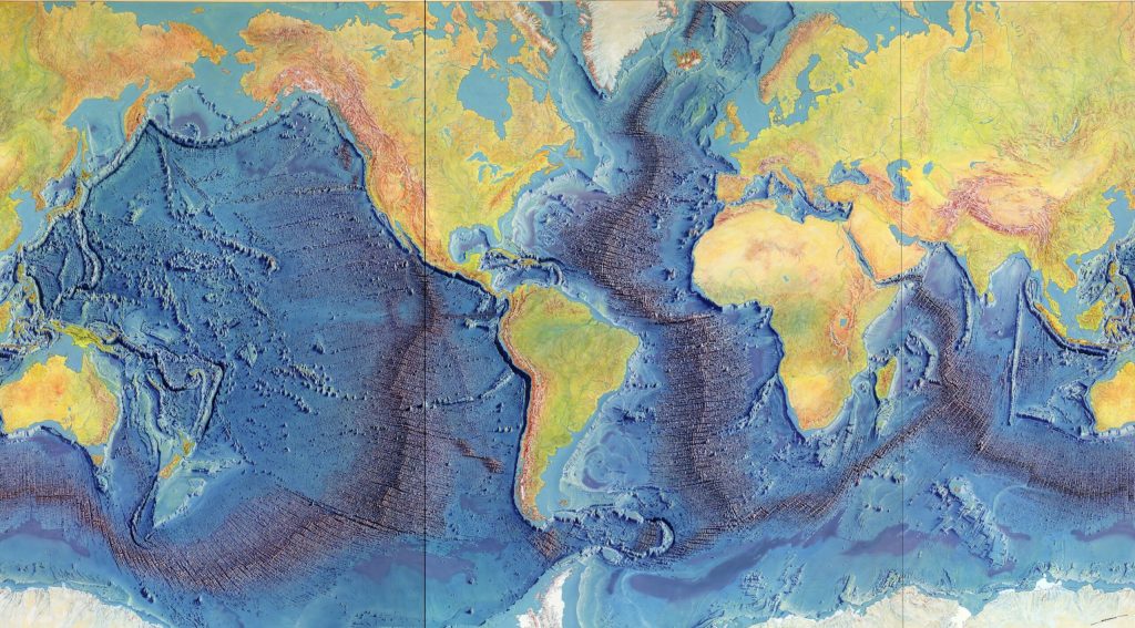
The seeds of the plate tectonic revolution had been sown earlier in the 20th century with Alfred Wegener’s theory of continental drift. Anyone looking at a world map or globe could see how the coastlines of certain continents, particularly South America and Africa, seemed to fit together like pieces of a puzzle, suggesting they were once joined. Wegener proposed that the continents were once joined together in a supercontinent called Pangaea and had gradually drifted apart over millions of years. While his ideas were initially met with skepticism, particularly regarding the mechanism that could drive such massive movements, compelling evidence from paleontology, glacial geology, and the jigsaw-like fit of continental coastlines slowly began to sway opinions. The discovery of seafloor spreading in the 1960s (itself a great story, featuring the brilliant geologist and cartographer Marie Tharp) which revealed that new oceanic crust was constantly being generated at mid-ocean ridges and that the ocean floor itself was moving like a conveyor belt, provided the crucial mechanism Wegener lacked.
Heinrich Berann’s 1977 painting of the Heezen-Tharp “World Ocean Floor” map, a landmark in cartography that showed how the earths plates in some areas are pulling apart while others collide. (Library of Congress)
It was against this backdrop of burgeoning evidence that the Geological Society of America convened one of its annual Penrose Conferences in December 1969 at the Asilomar Conference Center in Pacific Grove, California. Titled “The Meaning of the New Global Tectonics,” the event drew structural geologists from all over the world. The geological world changed overnight. A key figure in the conference was William R. Dickinson, a leading structural geologist whose work helped bridge the gap between traditional geological interpretations and the emerging plate tectonic framework. Dickinson’s research on sedimentary basins and tectonic evolution provided critical insights into how plate movements shaped the western United States, further solidifying the new theory’s acceptance.
These conferences were designed to be intimate gatherings where geologists could engage in focused discussions on cutting-edge research. The 1969 meeting proved to be a pivotal one. As UC Davis’ Moores, then a youthful figure who would become a leading voice of the “New Geology” in the West, later wrote, “the full import of the plate tectonic revolution burst on the participants like a dam failure”.
The Palmdale Road Cut on Hwy 14 in Southern California is a 90-foot slice through swirling sediments that have spent millions of years being squeezed and twisted by the San Andreas fault. Some say that this view of the fault is one of the best in all of California. (Photo: Erik Olsen)
Paper after paper presented at the conference demonstrated how the seemingly simple notion of large plates floating atop the Earth’s plastic mantle (the asthenosphere) could explain a vast array of geological phenomena. The location of volcanoes, the folding of mountains (orogeny), the distribution of earthquakes, the shape of the continents, and the history of the oceans all suddenly found a compelling and unified explanation within the framework of plate tectonics. Geologist John Tuzo Wilson famously referred to plate tectonics as ‘the dance of the continents,’ a phrase that captured the excitement and transformative nature of this intellectual breakthrough.
For Moores, the conference was a moment of profound realization. “It was a very exciting time. I still get goosebumps even talking about it,” he told the writer John McPhee. “A turning point, I think it was, in the plate tectonic revolution, that was the watershed of geology.” Moores had been contemplating the perplexing presence of ophiolite sequences – distinctive rock assemblages consisting of serpentines, gabbro/lava, and sediments – found high in the mountains of the West, including California. He suddenly grasped that these strange and “exotic” rock sequences were remnants of ancient ocean floors that had been lifted on top of the continent through the collision of tectonic plates.
Asilomar Conference Grounds Interior (Erik Olsen)
Moores reasoned that the serpentines and coarsely crystalline igneous rocks at the base of these sequences were characteristic of the rocks underlying all the world’s oceans. The “green rocks” in the middle (now the state rock of California) showed evidence of moderate pressure and temperatures, indicating they had been subjected to significant geological forces. By connecting these ophiolite sequences to the processes of plate collision and obduction (where one plate rides over another), Moores provided a powerful piece of evidence for plate tectonics and offered a new lens through which to understand the complex geological architecture of the American West.
His deduction was in line with what is now known about plate tectonics. The geological “confusion” apparent in the Rockies, the Sierra Nevada, and other western mountain chains was now understood as the result of neighboring plates bumping into each other repeatedly over vast geological timescales. The concept of terranes, foreign rock slabs or slices or sequences that have traveled vast distances and become accreted to continents, further illustrated the dynamic and assembly-like nature of California’s geological landscape.
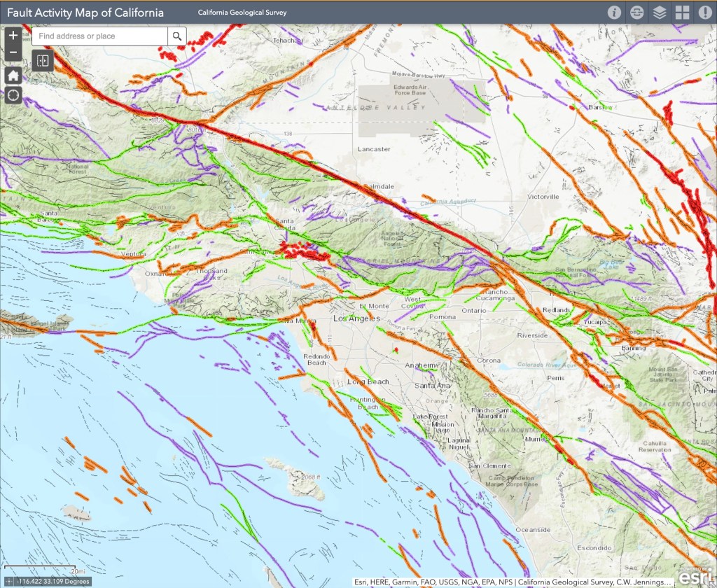
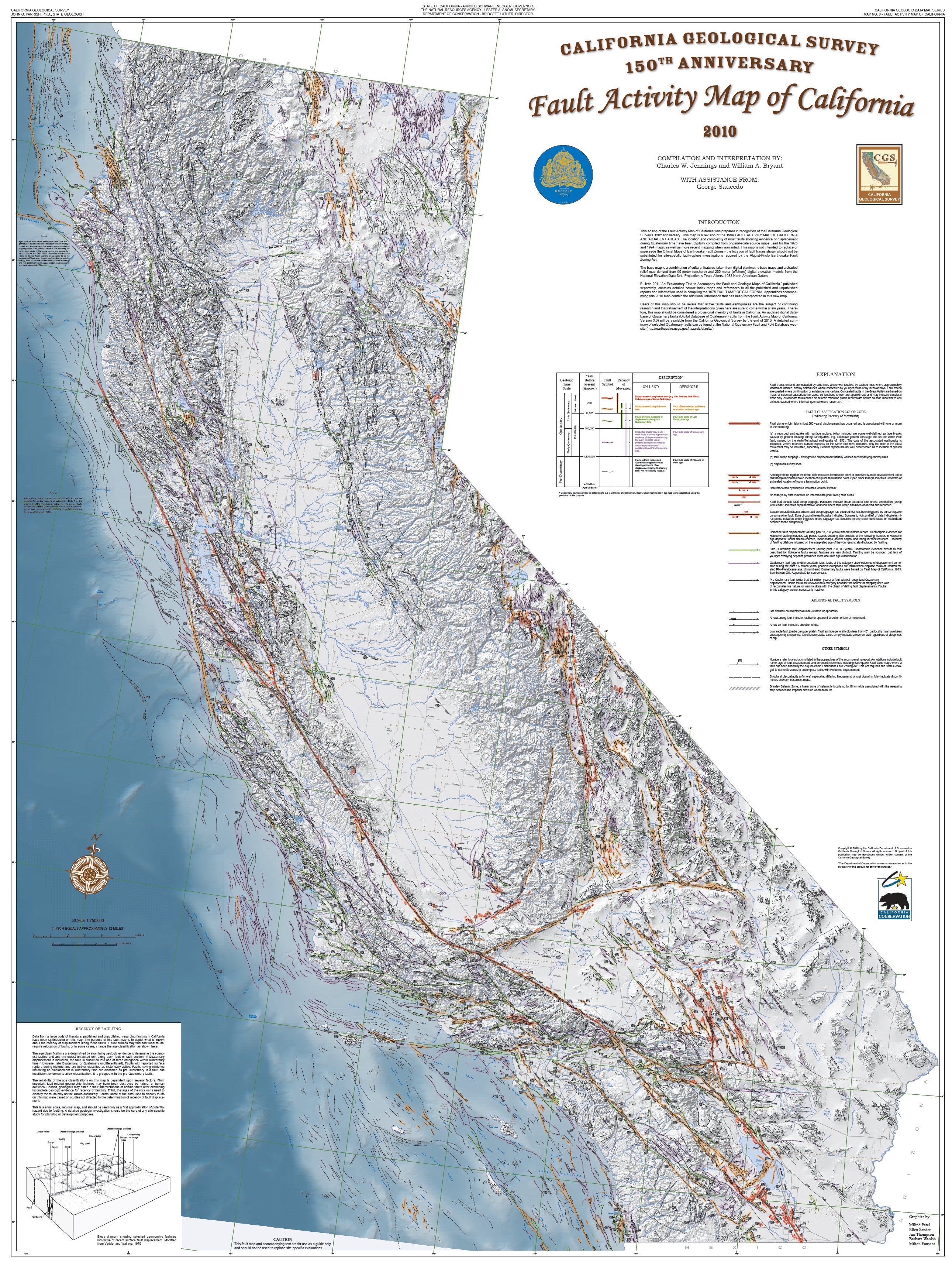
Fault Activity Map of LA Area in California (California Geological Survey) )
California, situated at the active boundary between the massive Pacific Plate and the North American Plate, became a prime natural laboratory for studying the principles of plate tectonics. The San Andreas Fault, a “right-lateral strike-slip fault” where the Pacific Plate slides northward relative to the North American Plate, is a direct consequence of this ongoing tectonic interaction. Places like Parkfield, California, lying directly on the fault, became the center of the seismic universe, offering invaluable opportunities to study the processes of locking and unlocking that precede earthquakes.
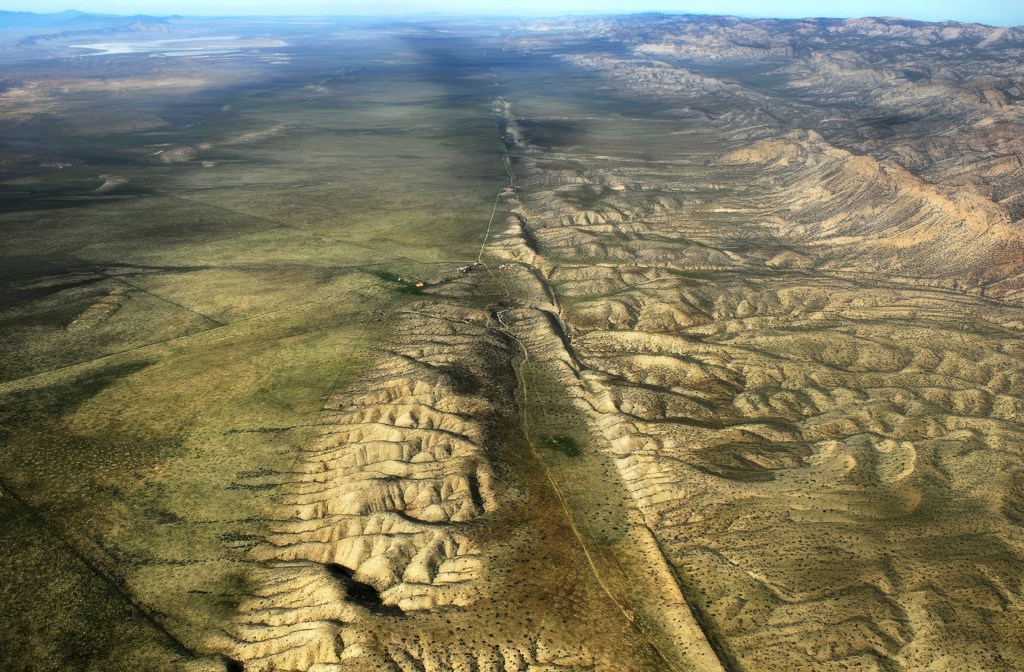
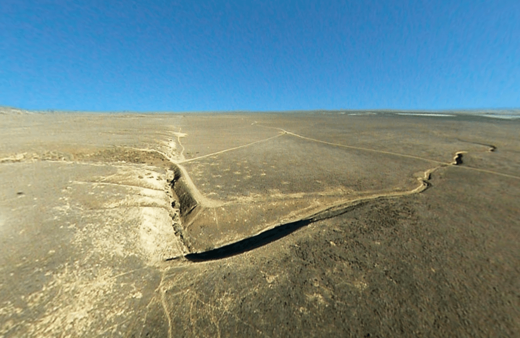
The San Andreas Fault at Wallace Creek. On January 9, 1857, the M 7.9 Fort Tejon earthquake occurred just north of the Carrizo Plain. Here, at Wallace Creek, the fault moved 30 feet (9m), forming the offset stream channel seen in the photo. (USGS)
The dramatic offsets of streams like Wallace Creek on the Carrizo Plain vividly demonstrate the horizontal movement along the fault. These offsets, where streams appear abruptly displaced, serve as clear, visual records of the fault’s slip history, showing just how much the land has shifted over time. Further proof of the movement of plates along the fault was uncovered in a remarkable investigation by Thomas Dibblee Jr., a pioneering field geologist who meticulously mapped vast regions of California. One of his most compelling discoveries was the striking geological similarity between rocks found at Pinnacles National Park and those in the Neenach Volcanic Field, located more than 195 miles to the southeast. Dibblee determined that these formations were once part of the same volcanic complex but had been separated by the gradual (but pretty damn quick in geological time) movement of the Pacific Plate along the San Andreas Fault over millions of years.
The insights gained from the plate tectonic revolution, sparked in part by that pivotal conference in Pacific Grove, continue to inform our understanding of California’s geological hazards and history. The work of scientists like Eldridge Moores and the subsequent advancements in the field have provided a robust framework for interpreting the state’s complex and ever-evolving landscape. The 1969 Penrose Conference marked not just a shift in scientific thinking but a fundamental unlocking of some of the Earth’s deep secrets, with California the place, once again, at the center of scientific advance.
Rare earth metals are now essential to the global economy, powering everything from smartphones and electric vehicles to wind turbines and defense systems. As China continues to dominate the market—producing more than 70% of the world’s supply—the urgency to find reliable alternatives has grown. The United States is locked in a high-stakes race to secure new sources of rare earth elements, along with other critical minerals like lithium and nickel, which are key to the clean energy transition. At the center of this effort is a storied mine in California that not only helped launch the rare earth industry decades ago but now stands as America’s most promising hope for rebuilding a domestic supply chain.
Mining shaped California’s growth, from the 1849 Gold Rush to key industries like mercury, silver, copper, tungsten, and boron. While some have declined, others, like the Rio Tinto U.S. Borax Mine in Boron, California, remain major global suppliers, while rare earth element extraction continues to be an important industry.
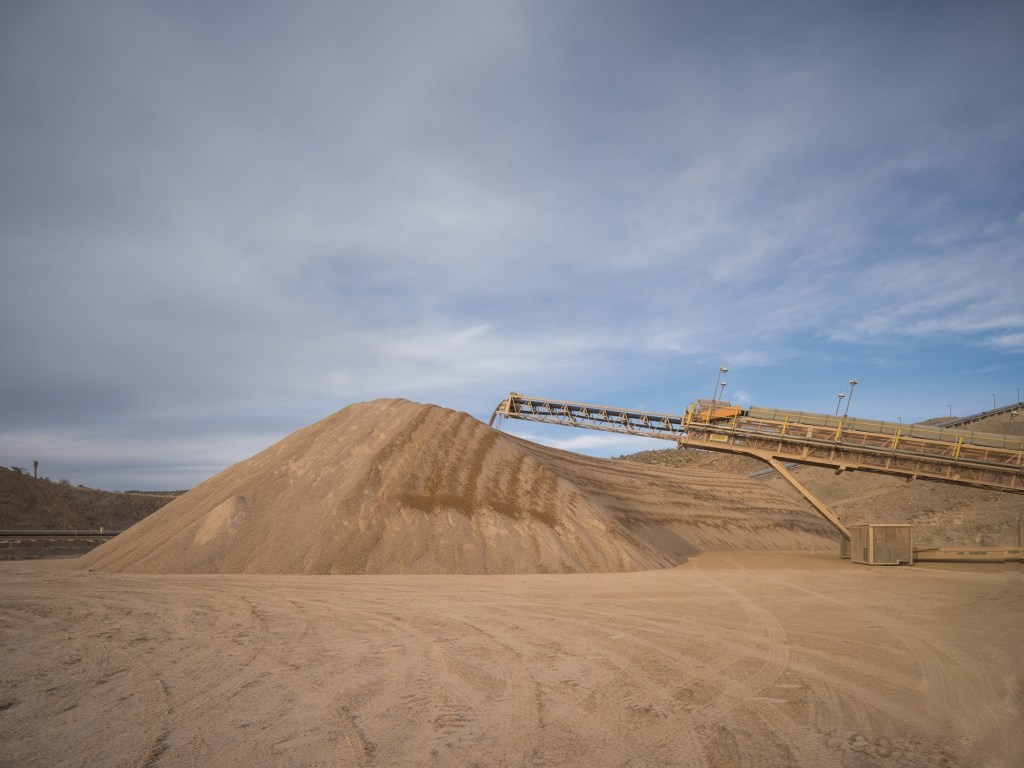
MP Materials’ Mountain Pass rare earths mine in California is a remarkable example of industrial resurgence and the strategic importance of critical metals in the modern era. Located in Mountain Pass in the remote Californian desert near the Nevada border (it’s easily viewable from Interstate 15), this mine, initially developed in the mid-20th century, has seen dramatic shifts in fortune, technology, and geopolitics, reflecting the complex role rare earth elements (REEs) play in global industries.
The rock at Mountain Pass contains an average of 7 to 8 percent rare earth elements—a remarkably high concentration by industry standards. This richness is a key factor in the mine’s potential. However, extracting these valuable elements from the surrounding material remains a challenge.
Discovered in 1949 while prospectors searched for uranium, the Mountain Pass deposit instead revealed bastnaesite, an ore rich in rare earth elements like neodymium, europium, and dysprosium. These elements are indispensable to modern technologies, powering innovations across consumer electronics, environmental solutions, and advanced military systems.
A computer-controlled arm deposits the raw crushed ore into a mound at the MP Materials mine and ore processing site in Mountain Pass, CA. (Courtesy: MP Materials)
Smartphones, for instance, are packed with rare earth elements that enable their functionality. Europium and gadolinium enhance the brightness and color of their screens. Lanthanum and praseodymium contribute to the efficiency of their circuits, while terbium and dysprosium enable the compact, high-performance speakers. Beyond smartphones, rare earth elements are essential to electric vehicles and renewable energy technologies, particularly in the production of permanent magnets. Thanks to their distinctive atomic structure, rare earth elements can produce magnetic fields far stronger than those generated by other magnetizable materials like iron. This exceptional capability arises from their partially filled 4f electron shell, which is shielded by outer electrons. This configuration not only gives them unique magnetic properties but also results in complex electronic arrangements and a tendency for unpaired electrons with similar spins. These characteristics make rare earth elements indispensable for creating the most advanced and powerful commercial magnets, as well as for applications in cutting-edge electronics.
Permanent magnets are among the most significant uses of rare earths, as they convert motion into electricity and vice versa. In the 1980s, scientists discovered that adding small amounts of rare earth metals like neodymium and dysprosium to iron and boron created incredibly powerful magnets. These magnets are ubiquitous in modern technology: tiny ones make your phone vibrate, medium-sized ones power the wheels of electric cars, and massive ones in wind turbines transform the motion of air into electricity. A single wind turbine can require up to 500 pounds of rare earth metals, highlighting their critical role in reducing greenhouse gas emissions.
MP Materials Processing Facility in Mountain Pass, California (Courtesy: MP Materials)
Additionally, rare earths play a significant role in environmental applications. Cerium is used in catalytic converters to reduce vehicle emissions, while lanthanum enhances the efficiency of water purification systems. Rare earth-based phosphors are employed in energy-efficient lighting, such as LED bulbs, which are central to reducing global energy consumption.
The importance of these elements underpins the strategic value of deposits like Mountain Pass, making the extraction and refinement of rare earths a critical aspect of both technological progress and national security. In the military domain, rare earths are integral to cutting-edge systems. They are used in the production of advanced lasers, radar systems, night vision equipment, missile guidance systems, and jet engines. According the the Department of Defense, for example, the F-35 Lightning II aircraft requires more than 900 pounds of rare earth elements. Alloys containing rare earth elements also strengthen armored vehicles, while lanthanum aids in camera lenses and night vision optics, giving military forces a strategic advantage.
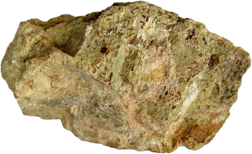
Bastnaesite concentrate. Bastnaesite is a mineral that plays a crucial role in the production of rare earth metals. (Courtesy of MP Materials)
To fully appreciate the significance of rare earth elements and their crucial role in the United State’s economic future, it’s essential to explore the history of Mountain Pass, one of the most important rare earth mines in the world. This storied site not only played a pivotal role in meeting the surging demand for these elements but also serves as a case study in the challenges of balancing industrial ambition with environmental responsibility.
The Molybdenum Corporation of America, later renamed Molycorp, initially capitalized on the booming demand for europium in color televisions during the 1960s. In 1952, the company acquired the Mountain Pass site, recognizing its rich deposits of rare earth minerals. As the first major player in rare earths in the United States, it began operations at Mountain Pass, establishing a foothold in the burgeoning industry. Over the ensuing decades, Mountain Pass became the world’s premier source of rare earths, serving a growing market for advanced materials.
By the 1990s, however, the mine faced significant challenges. Environmental damage caused by leaks of heavy metals andradioactive wastewater led to regulatory scrutiny and costly fines, culminating in the mine’s closure. During its dormancy, global rare earth production shifted overwhelmingly to China, which gained near-monopoly control over the market. By the time Molycorp attempted to revive the site in the early 2000s, it struggled against operational inefficiencies, low rare earth prices, and fierce Chinese competition. Molycorp eventually declared bankruptcy, leaving the mine idle once again.
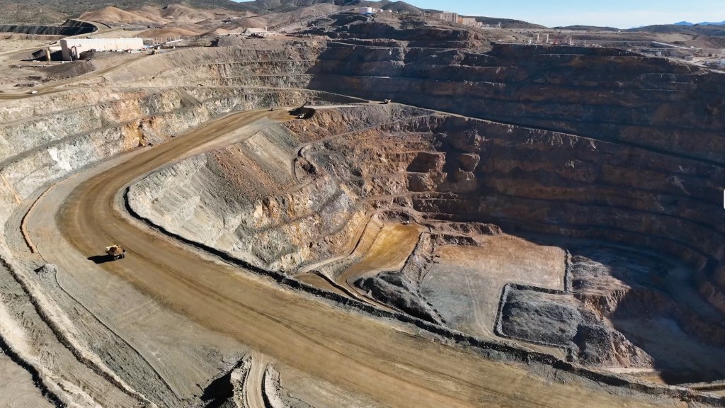
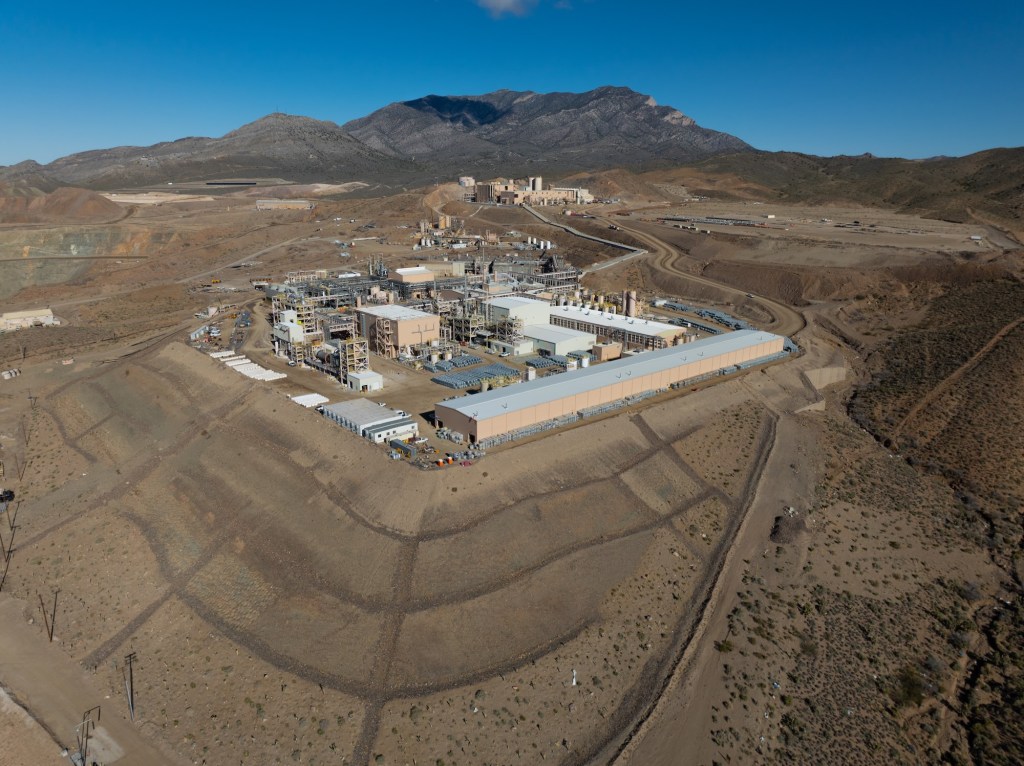
MP Materials Mine Facility (Photo: Erik Olsen)
In 2017, MP Materials, led by investors including Michael Rosenthal and Jim Litinsky, acquired the shuttered Mountain Pass mine after recognizing its untapped potential. Initially, they anticipated an established mining or strategic buyer would emerge. Faced with the risk of losing the mine’s permit and seeing it permanently closed through reclamation, they made the bold decision to operate it themselves. To restart operations, MP Materials partnered with Shenghe Resources, a Chinese state-backed company that provided critical early funding and became the company’s primary customer. Through this arrangement, MP shipped raw rare earth concentrate to China for processing, laying the foundation for a business model that was heavily reliant on the Chinese supply chain.
Over the next several years, Mountain Pass far exceeded expectations. By 2022, it was producing 42,000 metric tons of rare earth oxides—three times the best output achieved under its previous owner, Molycorp—and accounted for about 15% of global production. In 2024, the mine hit a U.S. production record with over 45,000 metric tons of REO in concentrate. But even as the mine’s output surged, MP Materials’ ties to China remained central to its operations. Shenghe not only purchased the bulk of that concentrate but also maintained an 8% ownership stake. In 2024, roughly 80% of MP’s revenue came from this relationship. That changed in 2025, when China imposed steep tariffs and new export restrictions. MP responded by halting all shipments to China, shifting instead to processing much of its output domestically and selling to U.S.-aligned markets like Japan and South Korea. It has since invested nearly $1 billion to build out a full domestic supply chain and launched a joint venture with Saudi Arabia’s Ma’aden, marking a decisive pivot away from reliance on China.
The processing of rare earth elements, particularly for high-value applications like magnets, involves a complex, multi-step value chain. It begins with extraction, where ores containing rare earths are mined, followed by beneficiation, a process that concentrates the ore to increase its rare earth content. Next, separation and refining isolate individual rare earth oxides through solvent extraction or other chemical methods. These refined oxides then undergo metallization, where they are reduced into their metallic form, making them suitable for further industrial use. The metals are then alloyed with other elements to enhance their properties, and finally, the material is shaped into high-performance magnets essential for applications in electric vehicles, wind turbines, and advanced electronics. Each of these steps presents significant technical, economic, and environmental challenges, making rare earth processing one of the most intricate and strategically important supply chains in modern technology.
Bastnaesite ore (Wikipedia)
Despite MP Materials’ success and efforts to ramp up facets of processing at its Mountain Pass mine in California, a critical portion of the rare earth refining process—metallization, alloying, and magnet manufacturing—remains dependent on other countries, including China and Japan. These procedures are both intricate and environmentally taxing, and California’s stringent regulatory framework, designed to prioritize environmental protections, has made domestic processing particularly challenging. Across the rare earths industry, this dependence on Chinese facilities exposes a significant vulnerability in the rare earth supply chain, leaving the United States and other countries reliant on foreign infrastructure to produce critical materials essential for technologies such as electric vehicles and advanced military systems.
However, to address the dependency on foreign processing, MP Materials is investing heavily in building a fully domestic rare earth supply chain. At its Mountain Pass mine in California, the company is enhancing its processing and separation capabilities to refine rare earth elements on-site. Meanwhile, at its new Independence facility in Fort Worth, Texas, MP Materials has begun producingneodymium-praseodymium (NdPr) metal and trialing sintered neodymium-iron-boron (NdFeB) magnets. This facility marks the first domestic production of these critical materials in decades, with the capability to produce 1,000 metric tons of magnets annually, amounting to the production of roughly half a million EV motors.
“This is our ultimate goal,” says Matt Sloustcher, EVP of Corporate Affairs for MP Materials. “To handle the entire separation and refining process on-site—but that ramp-up takes time.”
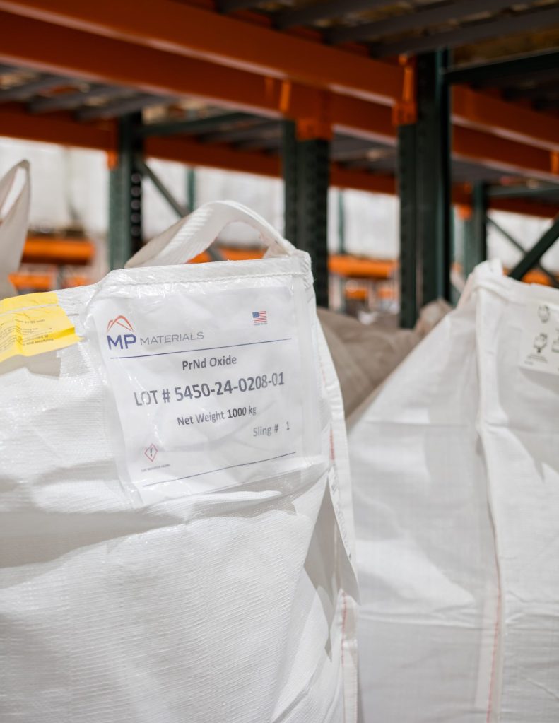
Individual slings of PrNd Oxide, the primary product produced at MP Materials. (Courtesy: MP Materials)
MP Materials asserts that the new U.S.-based rare earth supply chain it is developing will be a “zero discharge” facility, recycling all water used on-site and disposing of dry waste in lined landfills. That will make it a far more environmentally sustainable than its counterparts in Asia, where rare earth mining and processing have led to severe pollution and ecological damage. The company says it is making progress. MP Materials’ Sloustcher pointed California Curated to a Life Cycle Assessment (LCA) study published in the American Chemical Society which “found that NdFeB magnets produced from Mountain Pass ore have about one-third the environmental footprint of those from Bayan Obo, China’s largest rare earth mine.”
“With record-setting upstream and midstream production at Mountain Pass and both metal and magnet production underway at Independence , we have reached a significant turning point for MP and U.S. competitiveness in a vital sector,” said James Litinsky, Founder, Chairman, and CEO of MP Materials in a company release.
Interior view of the Water Treatment Plant at the MP Materials mine and ore processing site in Mountain Pass, CA. (Courtesy: MP Materials)
MP Materials has also partnered with General Motors to produce rare earth magnets for electric vehicles, signaling its commitment to integrating domestic production into key industries. The push for domestic EV production is not just about economic security but also about environmental sustainability, as reducing the carbon footprint of mining, processing, and transportation aligns with the broader goal of clean energy independence.
The resurgence of the Mountain Pass mine aligns with a broader initiative by the U.S. government to secure domestic supplies of critical minerals. Recognizing Mountain Pass as a strategic asset, the Department of Defense awarded MP Materials a $35 million contract in February 2022 to design and build a facility for processing heavy rare earth elements at the mine’s California site Additionally, the Department of Energy has been actively supporting projects to strengthen the domestic supply chain for critical minerals, including rare earth elements, through various funding initiatives.
Mountain Pass’s operations, however, highlight the challenges inherent in mining rare earths. The extraction process involves significant environmental risks, particularly in managing wastewater and tailings ponds. MP Materials claims to prioritize sustainable practices, yet its long-term ability to minimize environmental impact while scaling production remains under scrutiny. The mine’s bastnaesite ore, with rare earth concentrations of 7–8%, is among the richest globally, making it economically competitive. Still, as mentioned above, processing bastnaesite to isolate pure rare earth elements involves complex chemical treatments, underscoring why global production remains concentrated in a few countries.
Overhead view of the Crusher at the MP Materials mine and ore processing site in Mountain Pass, CA. (Courtesy: MP Materials)
Today, Mountain Pass is not only a critical supplier but also a symbol of U.S. efforts to reduce dependency on Chinese rare earth exports as well as other minerals such as lithium and copper vital to a transition to clean energy technology. As demand for REEs surges with advancements in green energy and technology, the increasing mine’s output supports the production of permanent magnets used in electric motors, wind turbines, and countless other applications. This resurgence in domestic rare earth production offers hope for a revitalized U.S.-based supply chain, reducing dependence on foreign sources and ensuring a more stable, sustainable future for critical mineral access.
However, significant obstacles remain, including the environmental challenges of mining, the high costs of refining and processing, and the need to develop advanced manufacturing infrastructure. Overcoming these barriers will require coordinated efforts from industry, government, and researchers to make domestic production both economically viable and environmentally responsible, ensuring a truly climate-friendly future. With the global race for critical minerals intensifying, MP Materials’ success demonstrates the potential—and challenges—of revitalizing domestic mining infrastructure in an era of heightened resource competition.
Walter Munk, often referred to as the “Einstein of the Oceans,” was one of the most influential oceanographers of the 20th century. Over a career that spanned more than 70 years, Munk fundamentally altered how we think about the oceans, contributing to our understanding of everything from wave prediction during World War II to deep-sea drilling in California. His work at the Scripps Institution of Oceanography in La Jolla, California, was groundbreaking and continues to influence scientific thinking to this day.
Walter Heinrich Munk was born in Vienna, Austria, on October 19, 1917. At 14, he moved to New York, where he later pursued physics at Columbia University. He became a U.S. citizen in 1939 and earned a bachelor’s degree in physics from the California Institute of Technology the same year, followed by a master’s in geophysics in 1940. Munk then attended the Scripps Institution of Oceanography and completed his Ph.D. in oceanography from the University of California in 1947.
Dr. Walter Munk in 1952. (Scripps Institution of Oceanography Archives/UC San Diego Libraries)
In the early 1940s, Munk’s career took a defining turn when the United States entered World War II. At the time, predicting ocean conditions was largely guesswork, and this posed a significant challenge for military operations. Munk, a PhD student at Scripps at the time, was recruited by the U.S. Army to solve a problem that could make or break military strategy—accurate wave prediction for amphibious landings.
One of his most famous contributions during the war came in 1944, ahead of the Allied invasion of Normandy. Alongside fellow oceanographer Harald Sverdrup, Munk developed a method to predict the size and timing of ocean waves, ensuring that troops could land safely during the D-Day invasion. Using their model, the Allied forces delayed the invasion by one day, a move that proved crucial in reducing casualties and securing the beachhead. This same wave prediction work was used again in the Pacific theater, particularly for landings on islands like Iwo Jima and Eniwetok. Munk’s contributions not only helped win the war but also laid the foundation for modern oceanography. Wave forecasting is now a standard tool for naval operations, shipping, and even recreational surfers.
Landing craft pass supporting warships in the Battle of Eniwetok, 19 February 1944. (U.S. Army)
After the war, Munk returned to Scripps, a place that would remain central to his career. Established in 1903, Scripps had been growing into a major center for oceanographic research, and Munk’s work helped elevate it to new heights. Located in La Jolla, just north of San Diego, Scripps was perfectly positioned on the California coastline to be at the forefront of oceanographic studies. Scripps is one of the premier oceanographic institutions in the world.
During the post-war years, Munk helped pioneer several new areas of research, from the study of tides and currents to the mysteries of the deep sea. California, with its rich marine ecosystems and coastal access, became the perfect laboratory. In La Jolla, Munk studied the Southern California Current and waves that originated across the Pacific, bringing new understanding to local coastal erosion and long-term climate patterns like El Niño. His research had a direct impact on California’s relationship with its coastline, from naval operations to public policy concerning marine environments.
Walter Munk in 1963 with a tide capsule.The capsule was dropped to the seafloor to measure deep-sea tides before such measurements became feasible by satellite.Credit Ansel Adams, University of California
While Munk’s contributions to wave forecasting may be his most widely recognized work, one of his boldest projects came in the 1960s with Project Mohole. It was an ambitious scientific initiative to drill into the Earth’s mantle, the layer beneath the Earth’s crust. The project was named after the Mohorovičić Discontinuity (named after the pioneering Croatian seismologist Andrija Mohorovičić), the boundary between the Earth’s crust and mantle. The boundary is often referred to as the “Moho”. The goal was revolutionary: to retrieve a sample from the Earth’s mantle, a feat never before attempted.
The idea was to drill through the ocean floor, where the Earth’s crust is thinner than on land, and reach the mantle, providing geologists with direct insights into the composition and dynamics of our planet. The project was largely conceived by American geologists and oceanographers, including Munk, who saw this as an opportunity to leapfrog the Soviet Union in the ongoing Cold War race for scientific supremacy.
The Glomar Challenger, launched in 1968, was the drill ship for NSF’s Deep Sea Drilling Project. (Public Domain)
California was again the backdrop for this audacious project. The drilling took place off the coast of Guadalupe Island, about 200 miles from the Mexican coast, and Scripps played a key role in organizing and coordinating the scientific work. The project succeeded in drilling deeper into the ocean floor than ever before, reaching 600 feet into the seabed. However, funding issues and technical challenges caused the U.S. Congress to abandon the project before the mantle could be reached. Despite its early end, Project Mohole is considered a precursor to modern deep-sea drilling efforts, and it helped pave the way for initiatives like the Integrated Ocean Drilling Program, which continues to explore the ocean’s depths today. For example, techniques for dynamic positioning for ships at sea were largely developed for the Mohole Project.
Munk’s work was deeply tied to California, a state whose coastlines and oceanography provided a wealth of data and opportunities for study. Scripps itself is perched on a stunning bluff overlooking the Pacific Ocean, a setting that greatly inspired Munk and his colleagues. Throughout his career, Munk worked on understanding the coastal dynamics of California, from studying the erosion patterns of beaches to analyzing how global warming might impact the state’s famous coastal cliffs.
Scripps Institution of Oceanography
His legacy continues to shape how California manages its vast coastline. The methodologies and insights he developed in wave prediction are now used in environmental and civil engineering projects that protect harbors, beaches, and coastal infrastructure from wave damage. As climate change accelerates the rate of sea level rise, Munk’s work on tides, ocean currents, and wave dynamics is more relevant than ever for California’s future.
Walter Munk’s contributions to oceanography stretched well beyond his wartime work and Project Mohole. He was instrumental in shaping how we understand everything from deep-sea currents to climate patterns, earning him numerous awards and accolades. His work at Scripps set the stage for the institution’s current status as a world leader in oceanographic research.
One of the most notable examples of this work was an experiment led by Munk to determine whether acoustics could be used to measure ocean temperatures on a global scale, offering insights into the effects of global warming. In 1991, Munk’s team transmitted low-frequency underwater acoustic signals from a remote site near Heard Island in the southern Indian Ocean. This location was strategically chosen because sound waves could travel along direct paths to listening stations in both the Pacific and Atlantic Oceans. The experiment proved successful, with signals detected as far away as Bermuda, New Zealand, and the U.S. West Coast. The time it took for the sound to travel was influenced by the temperature of the water, confirming the premise of the study.
Walter Munk in 2010 after winning the Crafoord Prize. (Crafoord Prize)
Munk passed away in 2019 at the age of 101, but his influence lives on. His approach to science—marked by curiosity, boldness, and a willingness to take on complex, high-risk projects—remains an inspiration for generations of scientists. He was a giant not only in oceanography but also in shaping California’s role in global scientific innovation. As the state faces the challenges of a changing climate, Munk’s legacy as the “Einstein of the Oceans” continues to be felt along its shores and beyond.


